
 Worksheets
Earth Science CSA Review 24/25
Total questions: 45
Worksheet time: 33mins

Which state had the most earthquakes over the six years?
Alaska
California
Hawaii
Nevada
Washington
Which state had the least earthquakes over the six years?
Alaska
California
Hawaii
Nevada
Washington
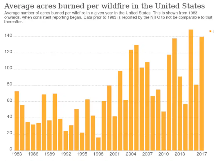
Which year had the least wildfires?
1998
2001
2003
2011
2012
Which year had the most wildfires?
1998
2001
2003
2011
2012
Why is it beneficial to be able to predict when and where natural hazards will occur?
So plans can be made to lessen their harmful effects.
To prevent them from happening.
To lessen the power of them.
So people can watch them happen.

Where would you choose to build a house to avoid an earthquake?
A
B
C
D
Where would you NOT want to build a house?
A
B
C
D
Why is it important to predict natural hazards?
It's not
To better prepare for them
So they can be stopped
So people can watch it
How do scientists use historical data to predict natural hazards?
It's not
They use the data to predict natural hazards.
They are able to see places that have had a natural hazard and predict that they are more likely to have them again.
How do scientists use historical data to predict natural hazards?
They don't
They can look at the weather conditions that were present before past hazards, and when the conditions are present again then a hazard is likely to happen.
They can look at the past data to predict when a hazard is likely to happen again.
The movement of sediment from one place to another.
weathering
erosion
deposition
The breaking down of rock into smaller pieces called sediment.
weathering
erosion
deposition
The driveway is long and winding because it bends around a huge old oak tree. The pavement near the tree bulges upward and has many more cracks than the other sections of the driveway.
weathering
erosion
deposition
There is a long meter-deep scar in the soil where a section of the riverbank has slipped into the water and is being washed down the river.
weathering
erosion
deposition
Over time, the Earth's rocks get broken down into smaller pieces. This is called _________________.
weathering
erosion
deposition
When weathered rock is carried away to another location, it is called __________________________
weathering
erosion
deposition
The continents are still moving today.
true
false
What explanation did Wegener give for fossils of the same plants and animals being found on continents far away from each other?
the ocean used to be dry
the continents had once been joined
land bridges
the plants and animals swam across the oceans
What are two main pieces of evidence for Wegener's theory of continental drift?
some continents look like they fit together like a jigsaw puzzle
fossils of the same species are found on different continents
the oceans have mountains under them
land bridges currently covered by ocean
magma oozes up where the sea-floor spreads apart

The letters on the map represent sectors of the ocean floor. The seafloor is spreading at a rate of 3-5 cm per year at the mid-Atlantic ridge.
In which sectors, is the newest rock located?
AB
BC
CD
AD
Draw two arrows to represent a divergent boundary at a red line.

Draw two arrows to represent a convergent boundary at a pink line.

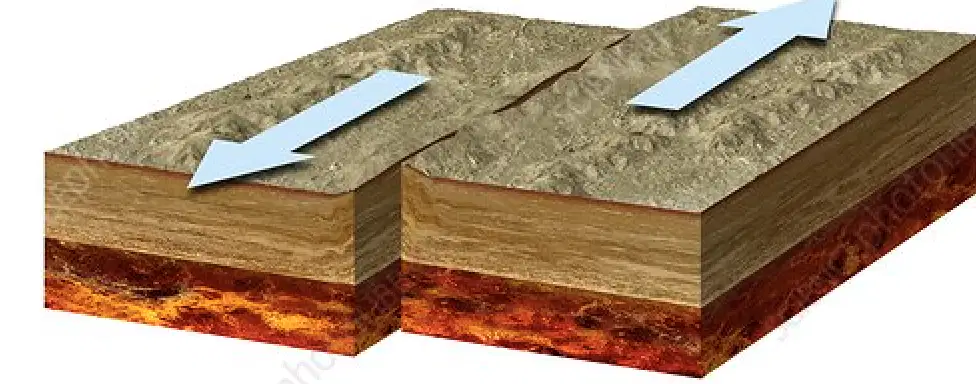
What boundary is shown in the image?
Divergent Boundary
Convergent Boundary
Transform Boundary
What if formed at this type of boundary?
Mountains
Valley
Earthquake

What boundary is shown in the image?
Divergent Boundary
Convergent Boundary
Transform Boundary
What is formed at this type of boundary?
Valley
Mountain
Earthquake
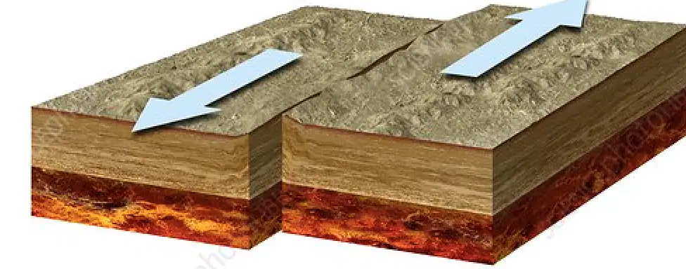
What boundary is shown in the image?
Divergent Boundary
Convergent Boundary
Transform Boundary
What is formed at this type of boundary?
Mountains
Valley
Earthquake

Where is the oldest crust?
A
B
C
D
Where is the newest crust?
A
B
C
D
At a convergent boundary the plates ___________
Move apart
Move together
Slide past eachother
At a divergent boundary the plates ___________
Move apart
Move together
Slide past eachother
At a transform boundary _____________ happen
mountains
earthquakes
mid-ocean ridges
Which shows a convergent boundary?
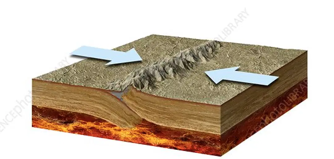
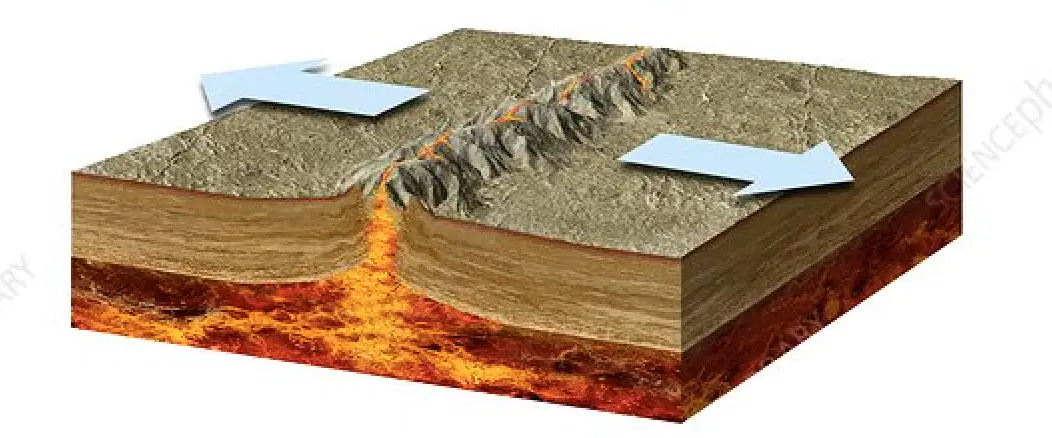
Which shows a divergent boundary?
Which shows a transform boundary?

What are the three types of Evidence that supports Alfred Wegener's Theory?
Fossils, Fish, and Land
Sedimentary, Magma, and Climate
Fossils, Land forms, and Climate
Climate, Land forms, and Metamorphic rock

What evidence did Wegener use to support his theory?
Continents and fossils fitting together/matching-up like puzzle pieces
glacier scars and other climate evidence from temperature
mountain ranges and rocks line up across continents
all of the above

According to the continental drift hypothesis, the presence of similar fossils in South America and Africa supports which scientific idea?
Animals easily and frequently travel from Africa to South America.
Species of animals probably traveled between continents on natural rafts (such as trees destroyed in tsunamis).
Land bridges once existed that connected the continents.
South America and Africa were once connected together.

What fossils were found on Africa and South America? (Select all that apply)
Mesosaurus
Cynognathus
Lystrosaurus
Glossopteris
What fossils were found on three or more continents? (Select all that apply)
Mesosaurus
Cynognathus
Lystrosaurus
Glossopteris
What fossils were found on Antartica and India? (Select all that apply)
Mesosaurus
Cynognathus
Lystrosaurus
Glossopteris
The type of plate boundary that forms mountains .....
How is the Grand Canyon formed?
Tectonic plates slide past each other creating the canyon.
Tectonic plates moved together creating the canyon.
Weathering and erosion from a river flowing.
It was manmade by digging.
How are caves formed?
Caves are formed by humans breaking a hole in a mountain.
Caves are made by groundwater breaking down rock and moving minerals that forms the cave.
Caves are made by groundwater bringing the rocks together.
Caves are made from erosion breaking down rocks.

