Worksheets
Ch. 5 Review
Total questions: 32
Worksheet time: 31mins
Convection currents occur when ______________________ energy transfers between a fluid.
potential
kinetic
thermal/heat
electric
Heat flow (convection current) in the ocean and the atmosphere is...
cool flows down - warm flows up
cool flows up - warm flows down
cool flows up - warm flows up
cool flows down - warm flows down
Convection currents occur in...
fluids
solids
______________is created by unequal heating of the Earth's surface.
conduction
radiation
wind
river movement
Ocean currents are created by
Dense cold water sinking
Dense cold water rising
Less dense water sinking
Less dense warmer water rising and more dense cold water sinking
When air is heated it becomes...
More dense
Less dense
Heavier
Moist
When air moves into the upper atmosphere it becomes...
Cool and heavy
Cool and light
Warm and heavy
Warm and light
Air sinking down toward the Earth's surface causes a...
High Pressure area
Low Pressure area
Air rising up above the Earth's surface causes a...
High pressure area
Low pressure area
Winds flow from...
High pressure to low pressure
Low pressure to high pressure
Due to the Coriolis effect and the Earth rotating counterclockwise, air (wind) will deflect....
clockwise in the northern hemisphere & counterclockwise in the southern hemisphere
counterclockwise in the northern hemisphere & clockwise in the southern hemisphere


Near which two cities are the low pressure systems located?
Seattle & San Francisco
Chicago & Seattle
Dallas & Houston
Chicago & Nashville

Near which city is the high pressure system located?
Seattle
Minneapolis
Dallas
Chicago

Which two cities are most likely to experience clear, dry weather?
Seattle & San Francisco
Chicago & Minneapolis
Chicago & Nashville
Dallas & Houston
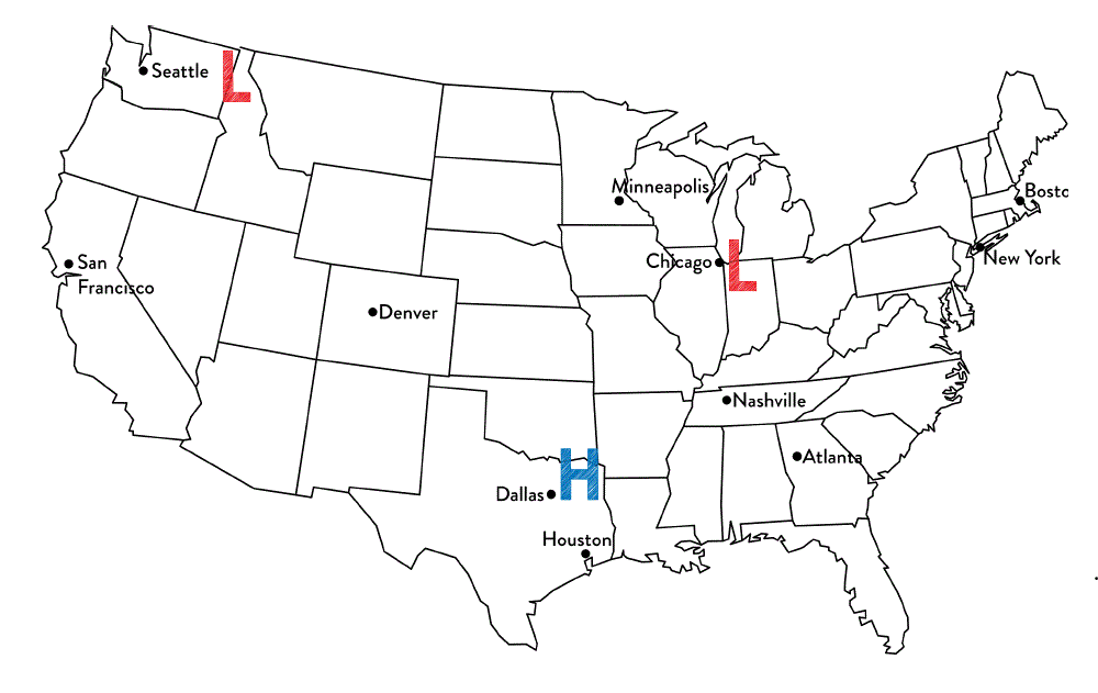
Tim said that Chicago is most likely to experience rainy weather. Jennifer thinks that Dallas is most likely to experience rainy weather.
Which student is correct?
Tim because Chicago is the closest to a low pressure system and they produce precipitation.
Jennifer because high pressure systems produce precipitation
Both students are correct because all systems produce precipitation
Neither of the students are correct because the cities are not close enough to the system.

Why does city "B" have clear skies?
It is in North America
There is not a front moving through city "B"
Clouds do not form in the West
It is located near a high pressure system

Which location is most likely experiencing warmer temperatures and higher humidity?
Location A
Location B
Location C
Location D

What type of weather is Denver most likely experiencing? Notice the type of front that has just passed through.
High humidity, cooler temperatures
Low humidity, cooler temperatures
Rainy, cold weather
Rainy, humid weather

Cold ocean currents generally come from

Which city on the map will have an increase in temperature over the next 24 hours?
Atlanta
Denver
St. Louis
Billings
Select 2 other names for a hurricane.
typhoon
cyclone
blizzard
earthquake
The scale used to measure the size of hurricanes is called the __________.
Saffir-Simpson Scale
Cal-Ripkin Scale
Richter Scale
Bart-Simpson Scale
In the northern hemisphere of the earth hurricanes circle __________.
clockwise
counter-clockwise
up and down
front to back
In the southern hemisphere of the earth hurricanes circle __________.
clockwise
counter-clockwise
up and down
front to back

Where do Hurricanes form?
NEAR the Equator
Away from the Equator
NEAR the North/South Poles