
 Worksheets
Weather And Climate Flash Cards/Quiz
Total questions: 74
Worksheet time: 37mins
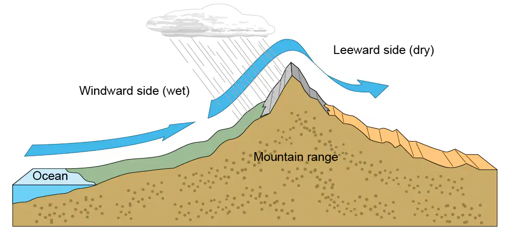
A redirection of wind when it is forced upward to travel over the top of the mountain and then down the other side
strong eastward winds in the stratosphere which blow horizontally around the earth
Jet streams blow
tool used to measure temperature; measures in degrees Fahrenheit or Celsius
Example.
"Room temperature" is 20 degrees Celsius
The main difference between a thermostat and a thermometer is that a thermostat regulates temperature, while a thermometer only measures it
an overall increase in average global temperatures due to the greenhouse effect (the increasing amount of carbon dioxide in Earth's atmosphere trapping more heat)
An energetic ocean wave in deep water caused by an underwater earthquake, its height increasing as it approaches land.
tool used to measure atmospheric pressure
A barometer reads higher pressure. This indicates
Lower temperatures and less precipitation.
What the standard air pressure in the atmosphere?
1 atm
5 atm
10 atm
Acid rain has higher or lower ph?
In acid rain
sulfur dioxide dissolves in the water droplets of clouds to make sulfuric acid
sulfuric acid dissolves in the water droplets of clouds to make sulfur dioxide
the phenomenon in which desert-like conditions appear on the leeward side of a mountain or mountain range.
Death Valley is the results of the
rain shadow effect
areas where air is turbulent and unstable; signified on a weather map by a black line
on a weather map
Troughs (on a Weather Map)
Katie wants to measure the amount of moisture in the air. She does not want the water in the air to ruin her hair. What instrument should she use?
hygrometer
anemometer
rain gauge
wind vane
Ms. Fayall observes that the wind is blowing more today than yesterday. Which tool could she use to measure the wind speed?
Anemometer
Wind vane
Rain guage
Thermometer
a measure of the amount of water vapor in the air
boundaries of an advancing mass of warm air; signified on a weather map by a red line with red semicircles
A phenomenon in which the surface temperature of the Pacific Ocean near the Equator becomes warmer than normal, which changes weather patterns around the world. One major effect is dry weather in Asia when they would normally be in the monsoon season.
substances used for insulation, aerosols, and refrigeration; they break apart ozone molecules
tool used to determine the amount and type of precipitation over a certain area using radio waves
lines on a weather map connecting two areas of similar barometric pressure
the region between the Tropic of Cancer (23.5 degrees north latitude) and the Tropic of Capricorn (23.5 degrees south latitude); warm temperatures; high rainfall
a measure of an area's short-term atmospheric conditions
When a warm air mass gets stuck between two cold air masses and lifted away from the Earth's surface. Causes dropping temperatures and rain; signified on a weather map by purple lines with purple triangles and semicircles next to each other.
occluded front
a weather map which includes pressure patterns, fronts, wind direction, and speed
synoptic map
The horizontal lines of the grid system that measure distance above and below the Equator
A redirection of wind when it is forced upward to travel over the top of the mountain and then down the other side
the region between 66.5 degrees north and south latitudes and the poles; cool summers and extremely cold winters; low rainfall
Tropical
Temperate
Polar
Desert
tool used to collect atmospheric data from a point high above the ground; the balloon is filled with helium or hydrogen and carries an attached probe into the atmosphere until the balloon bursts, dropping the probe
The areas between the Tropics of Cancer and Capricorn(23.5 degrees N and S) and the Arctic and Antarctic Circles (66.5 degrees N and S)
Temperate Zones
gases which, when present in elevated quantities in Earth's atmosphere, trap solar radiation and cause the planet to warm
A cycle of weather and ocean conditions in the Equatorial Pacific, that vary between normal, El Niño, and La Niña years
the side of the mountain facing opposite from the incoming wind
temperature boundary in the ocean that divides warmer surface waters from cold deep water
tool used to measure humidity in the air
Hygrometer / Psychrometer
anemoter
the side of a mountain facing the incoming wind
the amount of heat needed to raise the temperature of 1 mass unit of the material by 1 degree
a weather model, usually in text or map format, which uses data collected from weather balloons, satellites, ships, aircraft, and weather stations around the world to determine the likelihood of thunderstorm conditions developing
Computer Forecast Models
the trapping of the sun's heat in the atmosphere due to the increased presence of gases in the atmosphere; light is allowed to pass through, but heat is trapped, similar to the glass walls of a greenhouse
devices in Earth's orbit which collect weather data and allow scientists to quickly monitor atmospheric conditions
the part of a system in which some (or all) of the system's output is used as input for future operations
feedback loop
the part of a system in which some (or all) of the system's output is used as input for future operations
Example.
body temperature regulation - the body temperature is achieved and then measured for future changes needed
feedback loop
A curving of the flow of wind or water caused by Earth's rotation; to the right in the northern hemisphere, to the left in the southern hemisphere.
Partially solid water that falls to the earth as water and ice pellets.
tool used to determine the direction of the wind
wind vane
wind sock

multi-level clouds; impressive, towering appearance; indicate thunderstorms and severe weather
ultraviolet rays that can damage cells; can cause skin cancer and premature skin aging
Ultraviolet rays can cause skin cancer and premature skin aging.
UVB Rays
A wall that keeps water from flooding an area; often built of rock, dirt or sand.
tool used to measure wind speed
Rotating air from a thunderstorm that produces high wind speeds; typically lasting only 5 - 10 minutes.
a weather model which uses several models at one time in order to determine the models’ validity; if all the models predict the same weather conditions, they are likely correct
phenomenon in which strong trade winds cause significant upwelling along the eastern Pacific coast (South America) causing the surface temperature of the Pacific Ocean near the Equator along South America to become cooler than normal and changes weather patterns around the world; one major effect is a strong monsoon season in Asia
a molecule containing three oxygen atoms; absorbs some of the sun's rays to protect Earth's surface
Fronts that forms when a cold air mass and a warm air mass meet; brings lingering precipitation
the force exerted on an area due to the weight of the air in the atmosphere above
The formation of clouds and fog followed by days of precipitation indicates the formation of which type of front?
occluded
cold
stationary
warm
A weatherman on the local news is describing a cold front reaching and pushing up warm air later in the day. Which of the following is the weatherman most likely explaining?
Select all answers that apply.
an increase in air pressure
the development of thunderstorm clouds
the likelihood of rain
the development of clear, calm skies
One effect of mountains on climate is uneven rainfall. Which side of a mountain range generally has a rain shadow?
the leeward side
the weathered side
the glacial side
the windward side
The wind blows over the mountains toward the leeward side, which is generally drier. The mountains keep the clouds from reaching the leeward side, producing a rain shadow (region with less rain) there.
Which of the following human activities is least likely to alter the environment?
spilling oil in the ocean
dumping waste into the rivers and streams
overwatering the lawn
emitting pollution into the atmosphere
Overwatering a lawn can cause erosion, decrease water as a resource, and eventually decrease a number of organisms in that specific area. However, the overall negative impact is not as detrimental as the other answer choices.
Why are polar regions on Earth colder, on the average, than temperate regions?
ocean currents
ice caps at the poles
angle of the Sun's rays
limited vegetation at the poles
The more direct the Sun's rays are, the warmer that part of the Earth will be. The Sun's rays in polar regions are indirect, striking at an angle. These rays spread over a larger area and transfer less heat per area.
In the United States, automobiles are one of several primary producers of carbon dioxide that is emitted into the atmosphere. Imagine cars could run on each of the following fuels. Of the following, which fuel has the greatest potential to minimize the amount of carbon dioxide produced and emitted by automobiles?
Kerosene
Coal
Electricity from power plants
Diesel fuel
Since power plants can also operate with non-carbon based fuels, such as nuclear power and wind, electric cars have the greatest potential for minimizing carbon dioxide emissions.
Kerosene produces carbon dioxide as a byproduct of combustion.
The uneven heating of the Earth results in which of the following?
The melting of polar ice caps.
Large ice sheets found between 66.5 degrees north latitude and 66.5 degrees south latitude.
Deserts commonly found near the equator.
Deserts commonly found near the Tropic of Cancer and Tropic of Capricorn.
Deserts are commonly found near the Tropic of Cancer and Tropic of Capricorn, due to warm, moist air losing its moisture before reaching the Tropics.
Which of the following is not a human activity that would contribute to the formation of acid rain?
cooking with a natural gas stove
using a dam to generate hydroelectric power
burning coal to make electricity
using diesel fuel in combine harvesters
Which of the following would be the most effective strategy to reduce greenhouse gases?
increasing the number of smokestacks to reduce emission per stack
developing greater irrigation for crops
reducing the use of fossil fuels
adding lime to lakes that are highly acidic
Why might a meteorologist rely on satellites in his weather predictions?
to locate cold air fronts
to track the formation of cumulonimbus clouds
to locate cellular towers during a thunderstorm
to identify hazardous landforms
Satellites are commonly used to quickly track the formation of cumulonimbus clouds, which produce severe weather.

