
 Worksheets
1st 9 weeks Test Study Guide- Science
Total questions: 64
Worksheet time: 33mins
The process of breaking down rocks into smaller pieces by wind, water, or ice is called _______________________.
weathering
condensation
evaporation
melting
The movement of rock or soil from one place to another by water, wind, or ice is called _______________________.
erosion
condensation
photosynthesis
evaporation
When eroded materials settle in a new location, the process is called _______________________.
deposition
erosion
weathering
condensation
A sudden movement of rock and soil down a slope is called a _______________________.
landslide
earthquake
volcano
flood
Small pieces of rock or soil that have been broken down by weathering are called _______________________.
sediment
lava
crystals
fossils
Large masses of ice that move slowly over land and shape the landscape are called _______________________.
glaciers
volcanoes
deserts
lakes
Streams and ______________________ carve valleys and transport sediment over time.
rivers
mountains
clouds
forests
Lesson 2: The Rock Cycle
Igneous
Process: Igneous rocks form when _________.
magma or lava cools and solidifies
sediments are compacted and cemented
rocks are changed by heat and pressure
minerals dissolve in water and crystallize
Lesson 2: The Rock Cycle
Igneous
Source of Energy:
Heat from Earth's interior
Sunlight
Wind energy
Chemical reactions at the surface
Lesson 2: The Rock Cycle
Which of the following best describes the characteristics (appearance, texture, etc) of igneous rocks?
Formed from cooled magma or lava, often with a crystalline texture
Formed from layers of sediment, usually with visible fossils
Formed under high pressure and temperature, often with banded or foliated appearance
Formed from organic material, usually soft and crumbly
Sedimentary: Process: (How it forms) ________________________________
By weathering, erosion, deposition, compaction and cementation of sediments
By cooling and solidification of magma
By intense heat and pressure
By evaporation of water only
Sedimentary: Source of Energy: ________________________________
Sun
Wind
Earth's interior
gravity
Sedimentary: Characteristics: (appearance, texture, etc) include which of the following?
Layered appearance and may contain fossils
Glassy texture and no layers
Crystalline texture and formed from cooling magma
Metallic luster and high density
Metamorphic: Process: (How it forms) ________________________________
Forms from existing rocks changed by heat and pressure
Forms from cooling and solidification of magma
Forms from accumulation of sediments
Forms from evaporation of water
Metamorphic: Source of Energy: ________________________________
Heat and pressure from earth's interior
Sunlight causing weathering and erosion
Wind energy
Chemical reactions changing the rock
Metamorphic: Characteristics: (appearance, texture, etc) are typically:
foliated or non-foliated with crystalline texture
always glassy and vesicular
mainly composed of fossils
always layered with pebbles
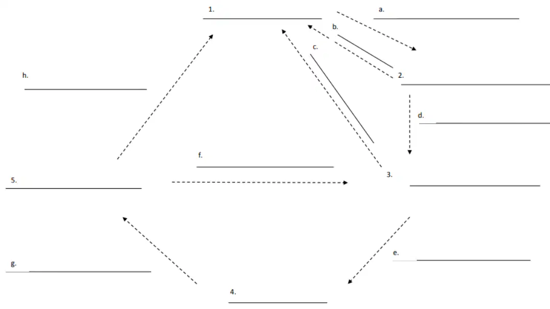
Fill in the blank in the Rock Cycle Diagram at position 1: ____________
Sediment
Sedimentary Rock
Metamorphic Rock
Lava
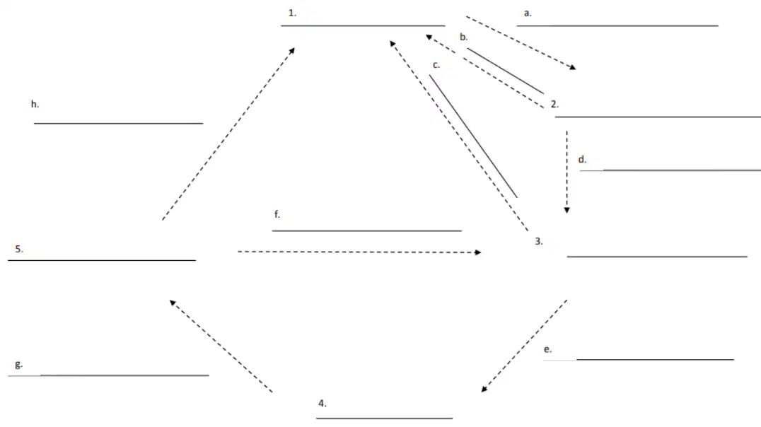
Fill in the blank in the Rock Cycle Diagram at position 2: ____________
Sedimentary Rock
Igneous Rock
Metamorphic Rock
Lava
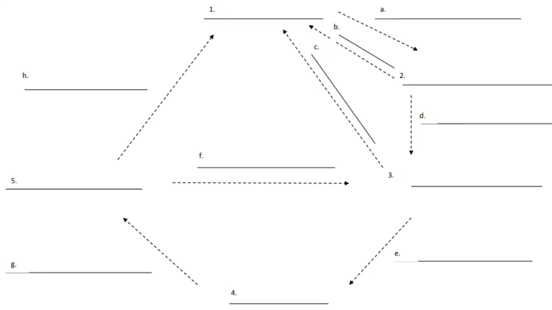
Fill in the blank in the Rock Cycle Diagram at position 3: ____________
Metamorphic Rock
Sedimentary Rock
Igneous Rock
Lava

Fill in the blank in the Rock Cycle Diagram at position 4: ____________
Sedimentary rock
Magma/lava
Weathering
Erosion
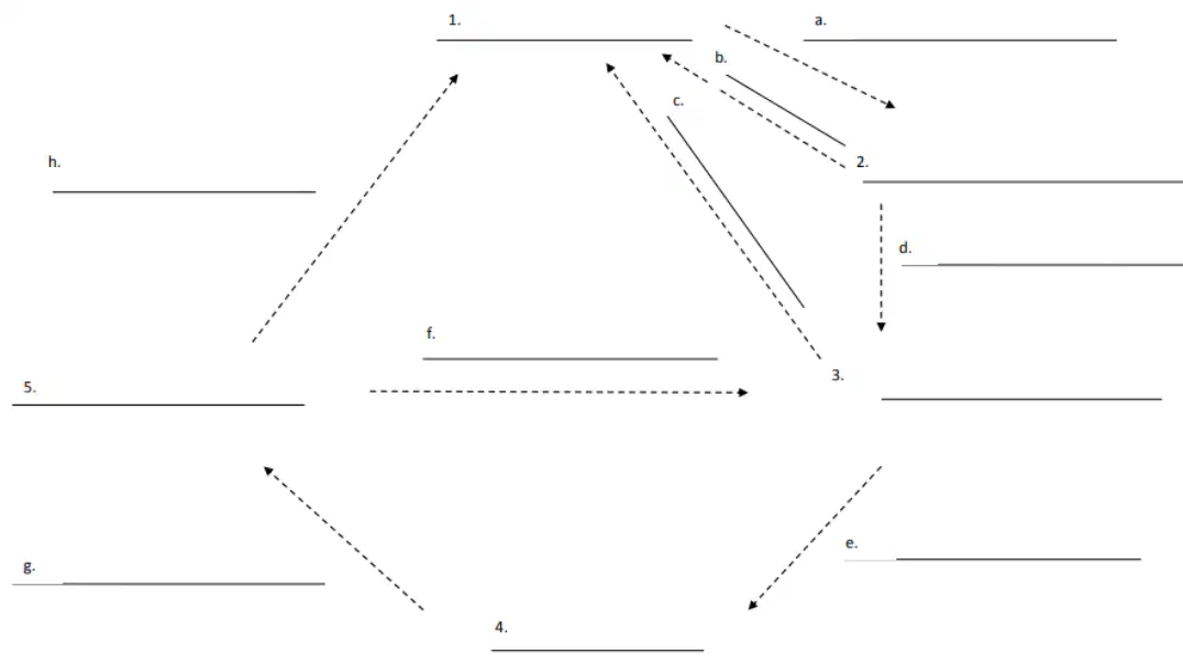
Fill in the blank in the Rock Cycle Diagram at position 5: ____________
Lava/Pressure
Sedimentary Rock
Metamorphic Rock
Igneous Rock
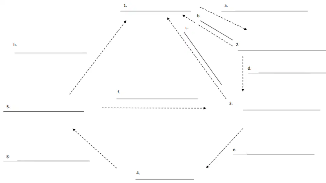
Fill in the blank in the Rock Cycle Diagram at position (a): ____________
layering, pressure, hardening
Melting
Compaction and Cementation
Cooling and Hardening

Fill in the blank in the Rock Cycle Diagram at position (b): ____________
Melting
weathering
cementation
Cooling and Hardening
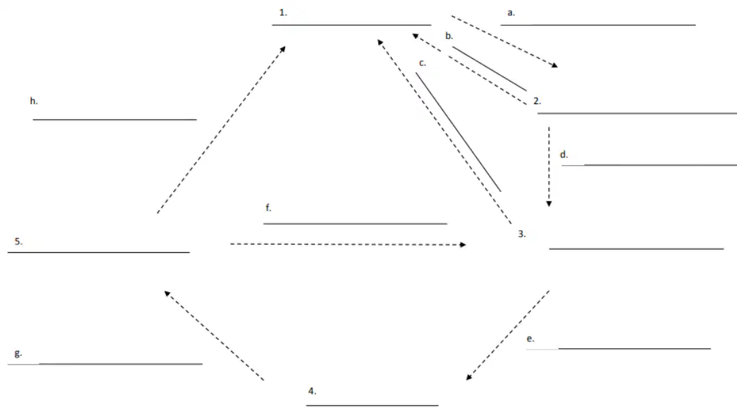
Fill in the blank in the Rock Cycle Diagram at position (c): ____________
weathering
Melting
cooling
Compaction and Cementation
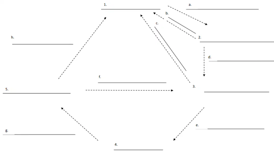
Fill in the blank in the Rock Cycle Diagram at position (d): ____________
great pressure and heat
Erosion
Compaction
Weathering
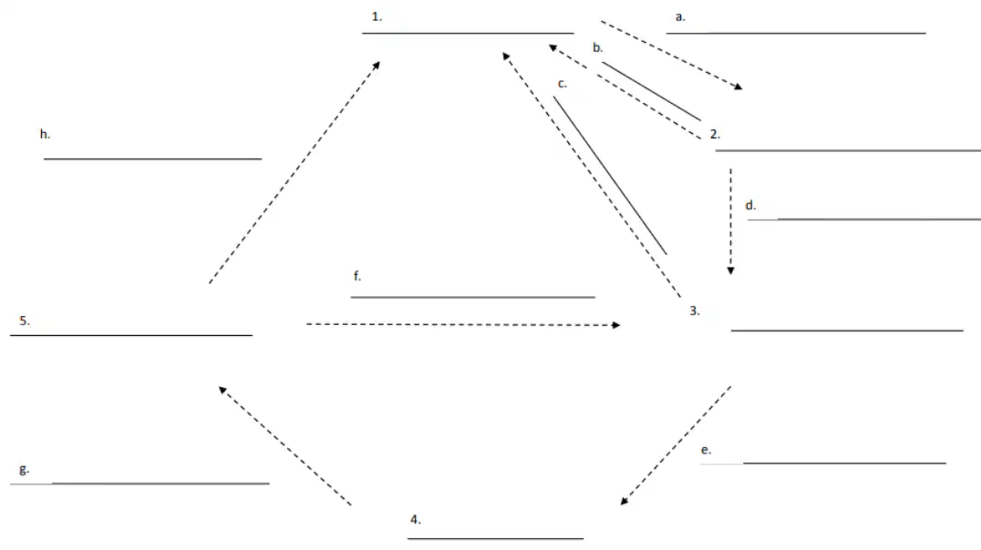
Fill in the blank in the Rock Cycle Diagram at position (e): ____________
pressure and heat
Erosion
Melting
Compaction
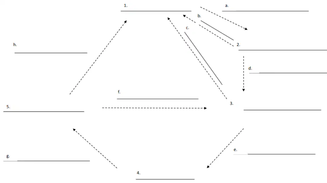
Fill in the blank in the Rock Cycle Diagram at position (f): ____________
Great pressure and heat
Melting
Compaction
Weathering
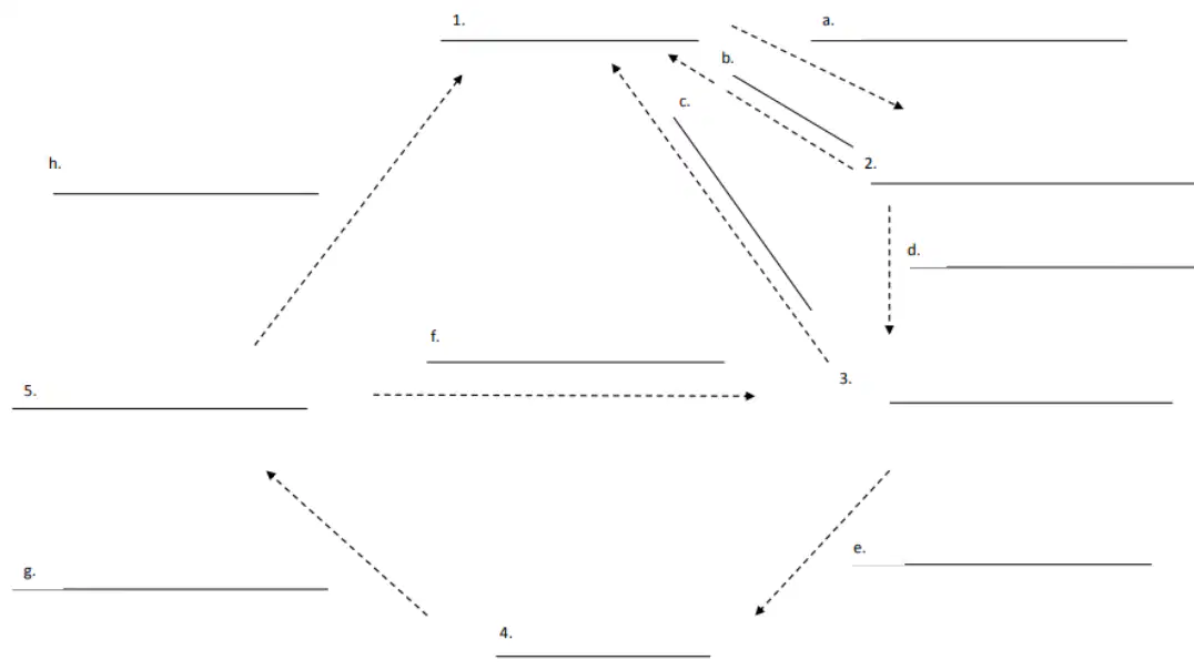
Fill in the blank in the Rock Cycle Diagram at position (g): ____________
Cooling and hardening
Melting
Erosion
Compaction
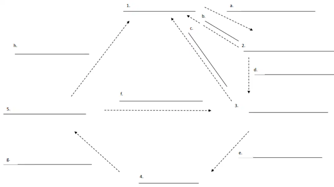
Fill in the blank in the Rock Cycle Diagram at position (h): ____________
Weathering
Melting
Erosion
Compaction
A volcanic hotspot is a location where magma rises through the mantle and can form which of the following?
Islands and volcanoes
Earthquakes only
Glaciers
Deserts
Sea-floor spreading adds which of the following to the surface of the earth?
New oceanic crust
Mountains
Rivers
Atmosphere
The age of rocks expected to be at a mid-ocean ridge is:
very young
very old
intermediate
ancient
Volcanic activity and earthquakes typically occur at:
tectonic plate boundaries
the center of continents
polar ice caps
deserts
A fault-block mountain range is created by which type of tectonic-plate boundary?
Divergent boundary
Convergent boundary
Transform boundary
Subduction zone
The theory of Pangaea states that:
all the continents were once joined together in a single landmass.
the Earth has always had the same continents as today.
continents have never moved from their current positions.
Pangaea was a large ocean that covered the Earth.
Define the following term: Delta
A landform at the mouth of a river where it splits into several outlets, formed from the deposition of sediment carried by the river.
A steep-sided valley formed by river erosion.
A narrow strip of land connecting two larger land areas.
A large body of saltwater surrounded by land.
Define the following term: Sediment
Particles of rock, minerals, or organic material that are transported and deposited by wind, water, or ice.
A type of volcanic rock formed from cooled lava.
A layer of soil that is rich in nutrients and supports plant growth.
A chemical compound found in ocean water.
Define the following term: Theory of Plate Tectonics
The scientific theory that explains the movement of Earth's lithospheric plates and the processes that occur at their boundaries.
A theory that describes the formation of stars in the universe.
The hypothesis that all continents were once joined in a single landmass.
A theory explaining the water cycle on Earth.
Define the following term: Mid Ocean Ridge
An underwater mountain range formed by plate tectonics where new oceanic crust is created.
A deep trench formed by the subduction of one tectonic plate under another.
A flat, featureless area of the deep ocean floor.
A coastal landform created by wave erosion.
Define the following term: Deep Ocean Trench
A deep, narrow depression in the ocean floor caused by the subduction of one tectonic plate beneath another.
A flat, shallow area of the ocean floor formed by sediment accumulation.
A large underwater mountain range formed by tectonic activity.
A circular coral reef structure found in shallow tropical waters.
Define the following term: Convection Current
The movement of fluid caused by differences in temperature and density, which transfers heat within the Earth's mantle.
A type of seismic wave that travels through the Earth's core.
The process by which rocks are broken down by chemical reactions.
The movement of tectonic plates due to gravitational forces.
Define the following term: Divergent Boundary
A tectonic plate boundary where two plates move away from each other, resulting in the formation of new crust.
A tectonic plate boundary where two plates slide past each other horizontally.
A tectonic plate boundary where two plates collide and one is forced beneath the other.
A boundary where two plates remain stationary and do not interact.
Define the following term: Convergent Boundary
A tectonic plate boundary where two plates move toward each other, often causing one plate to be forced below the other.
A tectonic plate boundary where two plates move away from each other, creating new crust.
A boundary where two tectonic plates slide past each other horizontally.
A region where the Earth's crust is stable and not affected by plate movement.
Define the following term: Transform Boundary
A tectonic plate boundary where two plates slide past each other horizontally.
A tectonic plate boundary where two plates move toward each other and collide.
A tectonic plate boundary where two plates move away from each other.
A boundary where one plate is forced under another plate.

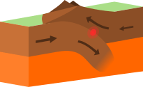
What type of plate boundary is this?
Plate
Divergent
Convergent
Transform

On average, the Americas move about one inch further away from Europe each year. The picture shows how Europe and America are moving.
Divergent
Sliding
Subduction
Convergent

F
G
H
J
Which of the following best describes a transform plate boundary?
Plates remain stationary
Plates slide past each other horizontally
Plates move toward each other
Plates move away from each other
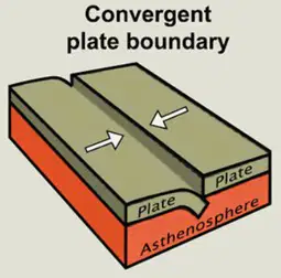
What geological formations are formed at convergent boundaries

What geological formations are formed at Divergent boundaries
Mid-ocean ridges and rift valleys, sea floor spreading
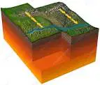
What geological formations are formed at Transform Boundaries
Volcanoes, mid ocean trenches

What natural force is most likely responsible for the formation of the narrow passage through the cliffs in the picture?
Blowing wind eroded the soil
Flowing water eroded the soil
Ocean waves deposited soil
Gravity moved and deposited soil
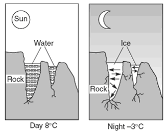
Which statement best explains why this process results in weathering?
Chemical weathering example
Physical weathering is caused by
True or False: Subduction is when one tectonic plate submerges or sinks under another plate
True
False

The San Andreas fault is a famous _______________ boundary
Convergent
Divergent
Transform
Continental
How does fossil evidence support Wegener’s hypothesis of continental drift?
Similar fossils found on far apart landmasses suggest that the continents were once a single land mass.
Fossil evidence suggests that the continents have always been in their current positions.
No similarities exist between fossils on different continents.
Plant and animal fossils show evidence of changes in earth’s polarity.

A student is developing a model of two tectonic plate boundaries.
The model is incomplete. Which set of information identifies the labels the student should use to complete the model and describes a process shown in the model?
A.
Label X: divergent plate boundary
Label Y: convergent plate boundary
Description: New crust is being formed at location X.
Label X: convergent plate boundary
Label Y: divergent plate boundary
Description: New crust is being formed at location Y
Label X: divergent plate boundary
Label X: divergent plate boundary
Label Y: convergent plate boundary
Description: Crust is being recycled by Earth’s mantle at location X.
Label X: convergent plate boundary
Label Y: divergent plate boundary
Description: Crust is being recycled by Earth’s mantle at location Y.
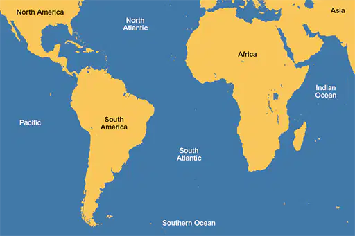
Fossils of the same reptile species on South America and Africa tells us what?
Continents were once connected
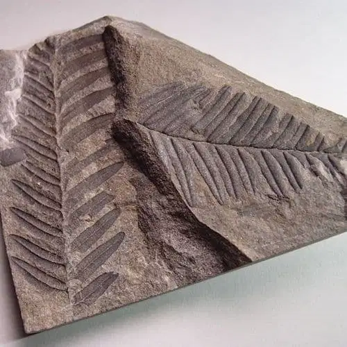
Fossils of tropical plants found on Antarctica is evidence that

Fossils of marine animals on mountaintops is evidence that

Similar plant fossils on India and Africa is evidence that
Plate movement caused continents to drift apart

