Worksheets
Unit 6: Weather, Convection & Hurricanes
Total questions: 62
Worksheet time: 58mins
Which explanation accurately describes convection within the ocean?
Earth's mantle heats water at the bottom of the ocean, causing the water to rise toward the surface. The air at the surface cools the water, causing the water to sink
Water near the ocean' surface is heated by air, causing it to sink toward the bottom of the ocean. As the water cools it sinks, causing it to rise back toward the surface
Water near the equator is warmer because of direct sunlight. Water near the poles is cold and dense. Warm water moves toward the poles and cold water moves toward the equator
The sun heats the surface of the water. The deeper the water, the colder it becomes. Warm water sinks and cold water rises
Energy from the sun creates pressure and temperatures differences on Earth's surface, which produce winds. These winds provide energy for the production of-
waves and ocean currents
water cycle and radiation
conduction and water cycle
ocean currents and conduction
What causes ocean waves to move ashore?
Evaporation of ocean water
Temperature of the coastline
Density of ocean water
Wind across the world
The power that drives convection within the atmosphere and oceans is-
air
wind
sun
conduction
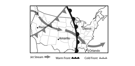
The Jet Stream is a global pattern of atmospheric movement that influences patterns in local weather. Based on the information provided in the weather map, which city shown most recently experienced a temperature rise?
Amarillo
Detroit
Orlando
Reno

The Jet Stream is a global pattern of atmospheric movement that influences patterns in local weather. Based on the information provided in the weather map, which city shown will likely see a drop in temperature in the near future?
Albany
Bismarck
Nashville
San Diego

The Jet Stream is a global pattern of atmospheric movement that influences patterns in local weather. Rain and even severe thunderstorms are often associated with the passage of a cold front. Based on this information, and that provided in the weather map, which city shown will most likely experience precipitation in the next few days?
Albany
Bismarck
Nashville
San Diego
Most of the water vapor in the atmosphere comes from evaporation of water from oceans. Most of this evaporation occurs where there is the greatest solar radiation, which is -
along the coast of Europe.
around islands in the Pacific.
near the Equator.
at both of the poles.

The circulation of warm and cold matter is called...
Convection
Wind
Evaporates
Rises
Which of the following factors contributes most to formation of hurricanes?
gravitational pull of the moon and sun
toxic chemicals in the atmosphere by industry
Glaciers melting in polar regions
solar radiation heating the oceans by equator

This is the calmest part of a hurricane.
eye wall
rain bands
eye
eye and rain bands
Where does the hurricane Start?
Over Cold Water
Over Antarctica
Over Warm Water
Overseas
Condition of the air that is influenced by heat and water.
Convection
Climate
Wind
Hurricane
How fast do winds have to be before it is considered a hurricane?
50 mph
75 mph
100 mph
40 mph
Hurricanes are the result of heat energy and water evaporated from which of the following.
natural springs in Texas
reservoirs heated by industry
oceans in tropics
large lake in Africa
This phenomenon that forces winds to spin.
Rain bands
Eye
Eye Wall
Coriolis effect
The strongest winds of hurricane come from?
The eye wall
The rain band
The eye
The center





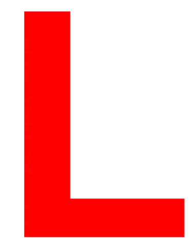


What does the "L" on a weather map mean
low pressure
lonely pressure
lumpy pressure
lucky pressure


Which lettered location is most likely experiencing clear sunny skies?
Location A
Location B
Location E
Location ?

When this symbol is present on a weather map, it represents
a cold air mass has taken over a warm air mass
a warm air mass has taken over a cold air mass
a cold air mass and warm air mass meet but neither have enough force to move each other
two cold fronts have collided and a warm air mass is pushing it upwards

What do the lines represent?
Pressure
Boundries
Patterns
Fronts

When this symbol is present on a weather map, it represents a/an _____
cold front
warm front
stationary front
occluded front
What causes El Nino?
Happens when the Pacific Ocean warms up affecting weather patterns worldwide.
Happens when Atlantic ocean cools down and causes severe weather in all oceans.
Happens in the Pacific ocean when the water cools down and circulates fast.
Happens when the Indian ocean mixes cold and warm currents.
True or false?
La Nina is characterized by cooler-than-average sea surface temperatures, in
the central and eastern Pacific ocean.
What regions are affected by El Nino?
Southern United States
Peru and Western South America
Central and Eastern Pacific ocean
Australia and Indonesia
What regions are affected by la Nina?
Africa
Latin America
South and South-East Africa
America
True or False?
El Nino occurs every 2 to 7 years
True or false?
La Nina occurs every 3 to 5 years