
Font size
 Worksheets
Geography IGCSE – Paper 11 MJ 2024 (Worksheet Extraction)
Total questions: 61
Worksheet time: 31mins
Suggest why birth rates are high in LEDCs such as Bolivia, Lesotho and Niger (4). Select all reasons that apply.
Lack of availability or affordability of contraception and family planning
Less education about contraception/family planning and about problems caused by high birth rates
Religious intolerance of contraception or abortion
High infant mortality leading families to have more children
High GDP per capita encourages smaller families
Describe the problems experienced by people living in urban areas with a high population density, such as Yaoundé. (5). Select all that apply.
Pressure on or cannot afford health services
Limited access to or unaffordable education
Expensive, cramped housing or squatter settlements/homelessness
Traffic congestion and jams
Abundant clean water supply
Give three advantages of living in the rural-urban fringe. (3). Select all advantages that apply.
Low-cost land
Good air quality and less air pollution
Close to green spaces or allotments
Easy to commute daily with less congestion
Higher noise pollution
Describe the impacts of urban sprawl on the natural environment. (4). Select all impacts that apply.
Loss of vegetation and deforestation
Loss of habitat with wildlife displaced
Reduction of biodiversity; ecosystems and food chains destroyed
Air and water pollution leading to soil degradation
Increase in species population diversity
Describe the causes and effects of one named type of pollution likely to be experienced by the people living in the area shown in Fig. 2.2. (5). The figure shows a water canal dividing two parts of a street with many cars and homes. Select all causes or effects that apply to water pollution in this setting.
Sewage discharge into the canal
Industrial/factory waste entering the waterway
Oil spills and runoff from vehicles near the street
Agricultural runoff carrying fertilizers into the canal
Waterborne diseases affecting residents
Select all statements that explain why equatorial and hot desert climates have different amounts of rainfall (4).
Equatorial air is humid while desert air is dry.
Equatorial areas have rising air while deserts have descending air.
Desert regions have more sources of water leading to more evaporation.
Equatorial areas are less likely to be affected by dry winds.
Deserts are more likely to be close to cold currents, which have less capacity to hold moisture.
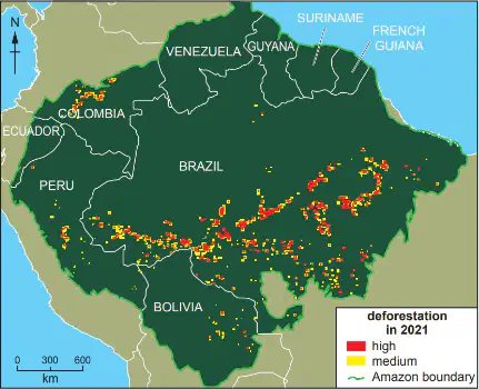
Using the map of deforestation in the Amazon rainforest, select all statements that help explain the distribution of recent deforestation (5).
Deforestation clusters along major roads and railways.
Areas distant from urban centers show more deforestation because wood is not in demand.
Different countries have different policies and attitudes toward the Amazon.
Conservation areas and indigenous reserves limit deforestation in some zones.
Government restrictions and approval requirements vary, preventing clearing in some parts.
Select all reasons why deposition occurs where a river enters the sea (4).
The river is carrying a large/heavy load.
The amount of energy increases as it meets calm seawater.
The speed slows down in calm seawater.
Flocculation occurs due to higher salinity/presence of salt water.
It becomes impossible for the river to carry its load.
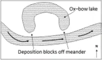
Select all statements that correctly describe how an oxbow lake is formed. You may use a labeled diagram (5).
Erosion occurs on outer bends while deposition occurs on inner bends.
The neck of the meander narrows.
During time of flood the river breaks through the neck.
The cut-off meander is sealed by deposition, forming an oxbow lake.
The river flows straight on and the meander separates.
Select all reasons why many dairies are located in rural areas (5).
Raw materials such as milk are available nearby as cows, sheep, and goats graze near farms.
Transport costs are higher in rural areas.
Milk is perishable and can be delivered to the dairy before it goes off.
Land is lower cost and there is plenty of space to build a dairy.
Dairies can be near raw materials even if far from markets because processed products can be transported widely.
Explain why there is a relationship between HDI and average number of years of education. (3)
Education is used as part of the HDI calculation.
High HDI countries have better quality/more schools and teachers.
In low HDI countries, children often work from an early age due to lack of legislation preventing child employment.
HDI excludes education so school years are unrelated.
In high HDI countries, boys and girls are treated equally and can attend school.
Compare the usefulness of HDI and the total GNP (Gross National Product) of a country as indicators of its level of development. (4)
HDI is a composite index that includes education and health indicators.
GNP values are directly comparable between countries even when currency values vary.
HDI is measured on a 0 to 1 scale, enabling useful comparison between countries.
A high GNP does not always mean a high quality of life or standard of living.
Total GNP does not consider population size.
Suggest reasons why the percentage of women employed in the tertiary sector in cities in India has changed between 1984 and 2018. (5)
Women and girls have become more qualified and skilled.
Gender equality/emancipation has enabled women to get jobs in banks and offices.
Growth of the tertiary/service sector has increased opportunities.
Fewer women migrated to cities during this period.
Smaller families mean women have more time to work.
Describe the problems which overpopulation may cause to the natural environment. (3)
Deforestation and loss of vegetation.
Reduction of biodiversity and disruption of ecosystems/food chains.
Atmospheric pollution, including greenhouse gases and acid rain.
Overpopulation reduces soil erosion by increasing plant cover.
Water pollution and reduced aquifer levels.
Explain how birth rates are being reduced in many LEDCs. (5)
Greater availability and use of contraception/family planning.
Legal access to abortion.
Later marriage means many people have children later in life.
Rising infant mortality increases desired family size.
Government anti‑natal policies such as a one‑child policy.
Describe four different problems faced by people living in large urban areas in LEDCs. (4)
Difficulty finding affordable housing; cramped squatter settlements/homelessness.
Traffic congestion and jams.
Abundant, easy access to clean water for all residents.
Air pollution from smog and car exhausts.
Poor sanitation and waterborne diseases.
Explain why urban areas are attractive to migrants from rural areas in LEDCs (5). Select all reasons that apply.
Employment is available with higher pay and better jobs
Better availability of hospitals and health care
Better access to water supply and sanitation
Urban areas have a higher risk of drought than rural areas
Access to public transport
Describe three different characteristics of a coral reef (3). Select all statements that correctly describe coral reefs.
They consist of living creatures such as polyps and zooxanthellae
They are composed primarily of calcium carbonate
They are typically found in deep, dark freshwater lakes
They include many different species and function as an ecosystem
They often have small holes in their structure and can be fragile
Describe the conditions that are required for the development of a coral reef (4). Select all conditions that are necessary.
Sunlight is needed; coral cannot grow where there is no light
Water temperatures between 18 – 27 ∘C
Water shallower than 60 – 70 metres
Water free from sediment and pollution (clear, clean)
Freshwater conditions are required
Explain how coral reefs and mangroves can benefit people living on the coast (5). Select all benefits that apply.
Protection of the coast from erosion, storms, flooding, and tsunamis
Provide food through fishing and catching crabs and shellfish
Tourism encourages economic development and earns revenue
Remove carbon from the atmosphere (carbon sinks), reducing global warming
They increase coastal erosion, damaging roads and housing
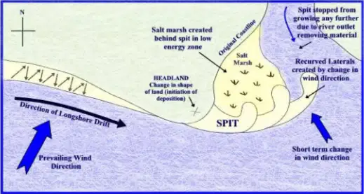
Explain how a spit is formed in a coastal area. Include a labeled diagram (7). Based on the diagram showing a coastline with prevailing wind direction, longshore drift moving beach material in a zigzag pattern, deposition at a change in the coastline, and a recurved end forming near a salt marsh, select all processes that contribute to spit formation.
Longshore drift transports material along the coast
Prevailing winds determine the angle of wave swash
Backwash returns at right angles to the shore, creating zigzag movement
Deposition occurs where the coastline changes, building out a spit
Strong offshore winds prevent longshore drift and stop spit formation
Explain why transpiration varies from time to time (2). Select all factors that can cause transpiration to change.
Temperature, sunshine, and light intensity
The amount of precipitation or water in the soil
Type of plants and the number or type of leaves
Wind speed that moves air away from the leaf surface, increasing the concentration gradient
Calm air always increases transpiration regardless of other conditions
Explain why overland flow varies from place to place (2) (Overland flow is water that runs across the land after rainfall). Select all factors that influence overland flow.
Amount, density, and type of plant cover or deforestation
Relief and angle of slope
Areas of bare rock
Differences in rainfall (more or less)
Soil infiltration rates
Explain how rivers, such as those shown in Figs. 4.2 and 4.3, erode their banks and bed. (5) Select all processes that apply.
Hydraulic action removing unconsolidated materials from banks and bed
Abrasion by transported load wearing the bed and banks
Corrosion/solution chemically dissolving rock such as limestone
Deposition building up sediment on the bed
Evaporation increasing atmospheric moisture over the channel
Some parts of South Africa experience tropical storms. Describe the problems this may create for farmers. (4) Select all impacts that apply.
Flooding of farmland and crops
Waterlogging of soils
Damage to or blocking of roads preventing transport of produce
Loss of livestock and farm animals
Fertilisers and topsoil washed away, leading to declining soil fertility
Explain how agricultural output can be increased. (5) Select all methods that apply.
Applying fertilisers or manure
Practising crop rotation
Irrigating fields
Mechanising farm operations
Terracing slopes to slow runoff and reduce erosion
Describe the impacts of air pollution. (4) Select all effects that apply.
Breathing difficulties such as asthma or emphysema
Reduced visibility and the formation of smog
Irritation and problems for skin and eyes
Global warming and climate change
Birth defects in humans and animals
Explain why increasing numbers of old dependents may cause problems for LEDCs, such as India. (5) Select all reasons that apply.
Reduction in the size of the workforce and economic activity
Higher dependency ratio placing strain on economically active people
Greater spending on health care and care homes for the elderly
Workers needing to pay higher taxes
Increased need for immigration to meet labour demand
Describe the location of industrial zones within urban areas. (4) Select all locations that apply.
Close to railway lines
Close to roads or motorways
Near the port or river
Around or near the CBD in the inner city
Around the edge of the city on the rural–urban fringe
Select the statements that correctly describe high-order services compared with low-order services. You should refer to examples. (5)
They are found mainly in cities while low-order services are found in most settlements.
They have a smaller sphere of influence than low-order services.
They require a larger threshold population.
They are used less frequently (for example, monthly rather than daily).
They typically sell more expensive comparison goods rather than convenience goods.
Select the features of an ideal location to place a wind vane. (3)
On a high point such as a roof.
In the open, not close to trees.
Where wind flow is not affected or blocked.
Inside a building to protect it from weather.
Where people are unlikely to tamper with it.
Select the actions you would take to use traditional instruments to measure and record wind direction and wind speed for one month. (5)
Use a weather vane to determine wind direction.
Refer to compass points to note the direction the arrow points.
Use an anemometer to measure wind speed.
Observe and record the figure shown on the instrument’s dial.
Record measurements at the same time each day.
Select the attractions of living along a coastline. (4)
Opportunities for fishing and related livelihoods.
Access to port and harbour trade activities.
Scenic beauty such as cliffs, beaches, and sea views.
Fresh air and cooler temperatures with a quiet, peaceful environment.
High likelihood of frequent earthquakes.
Select the processes that explain how longshore drift formed the Homer Spit. (5)
Prevailing winds approach the coast at an angle.
Waves and swash move sediment at the same angle set by the wind.
Backwash carries sediment straight back at right angles to the shoreline.
Beach materials move in a zigzag pattern along the coast.
Deposition occurs where the angle of the coast changes.
Select ways the tourist industry benefits people living in areas where tourism has developed. Do not write about employment. (4)
Improved roads and airports are constructed.
Tourist spending leads to a multiplier effect in the local economy.
Taxes raised from tourists support public services.
Investment improves water and electricity supply networks.
Tourism reduces investment in schools and hospitals.
During periods with few tourists, select the problems a country dependent on tourism may face. (5)
Unemployment or not enough seasonal work.
Irregular or low income and a decrease in the economy (e.g., GNP/GNI).
Businesses have to close or go bankrupt.
Severe traffic congestion due to overcrowded streets.
Workers must regularly work long hours.
During periods with many tourists, select the problems a country dependent on tourism may face. (5)
Overcrowded streets and shops.
Traffic congestion causing delays for locals.
Atmospheric and water pollution.
Water scarcity or rationing with priority given to tourists.
Inflation and price increases for goods such as food.
A temperate climate is never extremely hot or extremely cold and has moderate rainfall spread across the year. Explain how mixed farmers may benefit from a temperate climate. (3)
Moderate rainfall reduces the need for irrigation for crops and animals
Stable temperatures lessen stress on crops and livestock
High yields allow increased output and profit
Animals must be kept indoors due to cold extremes
Pasture grows well so there is less need for artificial feed
Describe how the relief of the land influences the way land is used for agriculture. (4)
Flat land is suitable for cultivation and can be easily mechanised
Steep slopes are more suited to grazing than to arable farming
Higher land has colder temperatures which may limit crops
Aspect affects sunshine; south-facing slopes in northern hemisphere favour ripening of vines
Slopes are never susceptible to soil erosion
Suggest reasons why a farmer in Queensland is likely to grow many different crops on the farm. (5)
Risk is spread because if one crop fails, others may succeed
Different market demands can be met by diversifying crops
Income can be received at different times through the year
Only flat land can be used, so diversification is limited
Different parts of the farm suit different crops, allowing crop rotation and maintaining soil fertility
Explain two different reasons why there may be small areas of high population density within large areas that are sparsely populated. (4)
Settlements near rivers or oases offer water supply in arid regions
Mining or oil drilling creates employment hubs
Valley floors in mountainous areas provide flatter land for settlement
Dry-point sites in marshy areas offer firmer ground
Remote areas far from transport routes
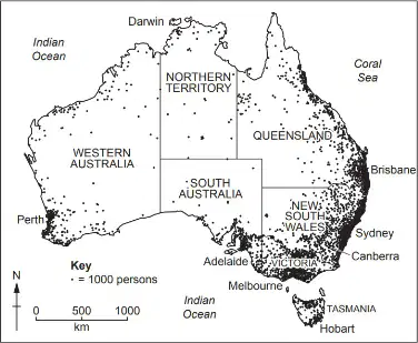
Using evidence from Figs. 1.2, 1.3 and 1.4 only, explain the reasons for the distribution of population in Australia. (5)
People concentrate where rainfall and water sources are available
Agriculture and irrigation are more productive in wetter areas
Mining regions attract workers and lead to roads and railways that reduce isolation
Coastal areas have tourism and employment opportunities that draw people
Most people choose deserts to avoid flood risk
The migration of people from rural areas may result in rural depopulation. Describe the problems caused for rural areas by rural depopulation. (4)
Closure or reduction of local services such as schools and clinics
Ageing population and labour shortages in farming and rural industries
Decline of the local economy and fewer jobs
Improved access to services due to lower demand
Underuse or abandonment of land and facilities
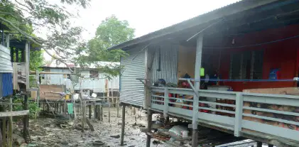
Using evidence from Figs. 2.2 and 2.3 only, identify the problems of living in the squatter settlement shown. Select all that apply (5 marks).
Homes built of flimsy materials easily damaged in storms
Waste and stagnant water present near homes indicating poor sanitation
Limited space and privacy inside small dwellings
Access to homes is difficult due to narrow, raised walkways
High-rise apartment blocks provide safe, serviced housing
Describe the likely changes to the characteristics of the river as it flows from X to Y when a tributary joins the main river. Select all that apply (4 marks).
Width increases
Depth increases
Cross-sectional area increases
Wetted perimeter increases
Gradient becomes steeper
As the river flows from X to Y, which changes are expected along its course? Select all that apply (4 marks).
Velocity increases
Gradient decreases (becomes less steep)
Average particle size in the river’s load decreases
Channel becomes more meandering
Erosion increases and deposition decreases
Suggest why flooding of the River Vltava may occur. Select all that apply (5 marks).
Prolonged heavy rainfall leading to saturated soils
Urbanisation creating impermeable surfaces that reduce infiltration
Snow and ice melting in the drainage basin
Deforestation reducing interception and increasing runoff
Construction of high levees that greatly increase channel capacity
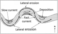
Match each stage in the formation of an oxbow lake to its description (7 marks).
Erosion on outer bends of a meander
Hydraulic action and abrasion remove material on the outer bank
Deposition on inner bends
Sediment builds up on the inner bank forming point bars
Meander neck narrows
Outer and inner bank processes bring the two loops closer together
Neck is cut through during a flood
River breaks through the neck creating a cutoff
New straighter river course forms and the old meander is sealed by deposition
Deposition isolates the former meander, forming the oxbow lake
Y is labelled on a convergent (destructive) plate boundary. Explain why plate movements cause volcanoes to erupt at Y. (3)
Plates converge; the denser plate subducts and melts to produce magma
Intense friction at the subduction zone generates heat that aids melting
Pressure from magma forces it up through cracks to erupt
Plates slide past each other smoothly with no sticking so magma cannot form
Z is labelled on a conservative plate boundary. Describe the processes which may result in earthquakes in the region around Z. (4)
Plates slide past each other at different speeds alongside one another
Friction causes plates to lock and pressure builds
When pressure is overcome, plates jolt and energy is released
Seismic waves spread vibrations to the surface
A subducting plate melts to form magma that triggers earthquakes at Z
Describe the problems caused for people by volcanic eruptions. (5)
Loss of life and injury
Ash clouds and toxic fumes cause health problems
Homes and property are damaged or destroyed
Immediate improvement in soil fertility reduces impacts on people
Air travel is disrupted by widespread ash clouds
Describe and explain the relationship between the level of development of a country and its employment structure. (5) (Note: Max 3 on each description/explanation.)
As development increases, the share of primary employment decreases
MEDCs have high tertiary and quaternary employment
Secondary employment rises and then falls as development increases
Mechanisation increases reliance on primary labour
Increasing wealth and demand for services raise tertiary employment
Explain why many people living in rural areas in LEDCs do not have enough water. (3)
Drought and high evaporation
Long distance from water sources or lack of reservoirs and wells
Abundant modern treatment plants provide free safe water to rural communities
Water sources are polluted; treatment or imported bottled water is unaffordable
Describe the problems caused by water shortages in rural areas of LEDCs. (4)
Crops fail or have low yields; irrigation water is lacking
Farm animals die
People suffer dehydration and water-borne diseases due to lack of safe drinking water
Improved sanitation reduces disease immediately
People migrate away or conflict occurs over scarce water
Select two advantages and two disadvantages for LEDCs when large numbers of people move away from them. Select all that apply. (4)
Remittances sent back to families
Less pressure on employment
Loss of skills/brain drain
Fewer people paying taxes
More food produced
Select reasons why many workers and their families move away from LEDCs such as the Philippines. Select all that apply. (5)
Difficulty finding employment
To obtain better education/training
High pay in the home country
To obtain better healthcare
To escape war/conflict or an unstable government
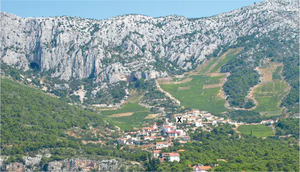
Describe the site and situation of settlement X shown in the photograph. Select all the features that apply. (3)
In a valley with gentle lower slopes
At the base of steep cliffs in the mountains
On a coastal plain next to the sea
In shelter
Far from farmland and forest
Suggest reasons why the settlement at X has remained small and not grown into an urban area. Select all that apply and develop your choices. (4)
Limited flat land to build on because of steep slopes
Isolation from main roads and transport routes
Presence of large factories providing many jobs
Cold winters and blocked roads make building and travel difficult
Abundant employment opportunities nearby
Select reasons why many people aged 65 and over would like to live in a rural area. Select all that apply. (5)
Quiet and peaceful, less stressed
More open space and closer to nature
Higher crime rates
Less air pollution
Need to commute to work daily
Explain why many people still live in areas where earthquakes occur. Select all that apply. (4)
Poverty prevents them from moving
Emotional attachment to place and family ties
Close to work and schools
Unaware of danger or prepared to take risks
Government bans building in safe areas
Explain the advantages of living close to a volcano such as Mount Vesuvius. Select all that apply. (5)
Fertile soils give high crop yields
Tourism provides jobs and income
Geothermal energy and hot water as renewable power
Scenic beauty attracts residents and tourists
Frequent lava flows destroy homes

