Search Header Logo
Earth Science SOL Review Sheet #8	:  Weathering and Erosion

Earth Science SOL Review Sheet #8 : Weathering and Erosion

Assessment

Presentation

Science

9th - 12th Grade

Practice Problem

Medium

NGSS
MS-ESS2-2, MS-ESS2-4, MS-ESS2-1

+1

Standards-aligned

Created by

Tracy Andrews

Used 7+ times

FREE Resource

4 Slides • 22 Questions

1

Earth Science SOL Review Sheet #8 : 

Weathering and Erosion

2

·   Permeability is a measure of the ability of a rock or sediment to transmit water or other liquids.

·   Water does not pass through impermeable materials.

·   Geological processes, such as erosion, and human activities, such as waste disposal, can pollute water supplies.

·   The three major regional watershed systems in Virginia lead to the Chesapeake Bay, the North Carolina Sounds, and the Gulf of Mexico.

·   Interpret a simple groundwater diagram showing the zone of aeration, the zone of saturation, the water table, and an aquifer.

·   Interpret a simple hydrologic cycle diagram, including evaporation, condensation, precipitation, and runoff.

·   Locate the major watershed systems on a map (Chesapeake Bay, Gulf of Mexico, and North Carolina Sounds).

 ·   Weathering is the process by which rocks are broken down chemically and physically by the action of water, air, and organisms.

·   Erosion is the process by which Earth materials are transported by moving water, ice, or wind.

·   Deposition is the process by which Earth materials carried by wind, water, or ice settle out and are deposited.

·   Soil is loose rock fragments and clay derived from weathered rock mixed with organic material.

·   Karst topography includes features like caves and sinkholes.

·   Karst topography forms when limestone is slowly dissolved away by slightly acidic groundwater.

·   Where limestone is abundant in the Valley and Ridge province of Virginia, karst topography is common.

Essential Knowledge and Skills

3

Let's practice some terms you need to know.

Vocabulary

media

4

Multiple Choice

When a rock's composition is altered and broken down by acids in the environment

1
Chemical weathering
2
Erosion
3
Physical weathering
4
Sedimentation

5

Multiple Choice

The process by which products of erosion are laid down

1
Weathering
2
Erosion
3
Deposition
4
Sedimentation

6

Multiple Choice

The process by which Earth materials are carried away and are deposited by wind, water, gravity, or ice

1

Erosion

2

Compaction

3

Transportation

4

Weathering

7

Multiple Choice

Water located underground in the zone of saturation

1
Surface water
2
Aquifer
3
Rainwater
4
Groundwater

8

Multiple Choice

A landscape that develops from the action of groundwater in areas of easily soluble rocks characterized by caves, underground drainage, and sinkholes

1
Desert landscape
2
Glacial landscape
3
Volcanic landscape
4
Karst topography

9

Multiple Choice

The rate at which a fluid can move through a material

1
Viscosity
2
Density
3
Permeability
4
Fluidity

10

Multiple Choice

Natural processes that takes big rocks and turn them into small rocks or sediments (rain, wind ice-wedging etc.)

1

Volcanic activity

2

Physical Weathering

3

Metamorphism

4

Sedimentation

11

Multiple Choice

Particles of rock or organic materials that have been carried along and deposited by water, wind, or glaciers; small pieces of rock, shell, and other material that are broken down by the processes of weathering

1
Sediment
2
Granite
3
Clay
4
Soil

12

Multiple Choice

Funnel-shaped depressions that result from the dissolution of limestone along cracks

1
depressions
2
potholes
3
craters
4
sinkholes

13

Multiple Choice

All of the land or area that drains into a specific river system

1
River basin
2
Floodplain
3
Watershed
4
Delta

14

Multiple Choice

The upper surface of a zone of saturation

1
permeable layer
2
aquifer boundary
3
groundwater level
4
water table

15

Multiple Choice

Breaking down of rocks and other material at the Earth’s surface

1
Erosion
2
Sedimentation
3
Volcanism
4
Weathering

16

Multiple Choice

The underground region where the pores are filled mostly with air

1
Phreatic zone
2

Zone of saturation

3

Zone of aeration

4
Aquifer

17

Multiple Choice

The underground region where all of the pores are filled with water

1

Zone of saturation

2
Aquifer
3
Water table
4

Zone of aeration

18

Now, let's practice some SOL-type questions.

SOL Review

media

19

Multiple Choice

Question image

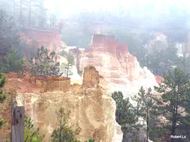
The photograph shows an eroded plateau found in the southwestern United States. The landscape was developed by the processes of–

1

crustal uplift and stream erosion

2

crustal folding and stream erosion

3

crustal uplift and glacial erosion

4

crustal folding and glacial erosion

20

Multiple Choice

Which of the following Virginia provinces has the most karst topography?

1

Coastal Plain

2

Blue Ridge

3

Piedmont

4

Valley and Ridge

21

Multiple Choice

Question image

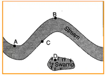
The map shows the area surrounding a meandering stream. At which point is erosion greatest?

1

Point A

2

Point B

3

Point C

4

Point D

22

Multiple Choice

Question image

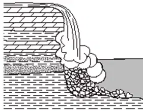
The cross section below shows sedimentary rocks being eroded by water at a waterfall. The sedimentary rock layers are being weathered and eroded at different rates primarily because the rock layers-

1

formed during different time periods

2

contain different fossils

3

have different compositions

4

are horizontal

23

Multiple Choice

Question image

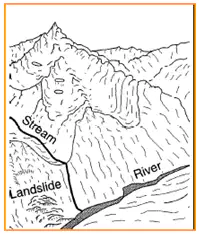
The diagram shows a glacial landscape. Which evidence suggests that ice created this landscape?

1

U-shaped valleys

2

many stream valleys

3

sorted sediment on the valley floor

4

the landslide near the valley floor

24

Multiple Choice

Question image

The diagram below shows granite bedrock with cracks. Water has seeped into the cracks and frozen. The arrows represent the directions in which the cracks have widened due to weathering. Which statement best describes the physical weathering shown by the diagram?

1

This type of weathering occurs only in bedrock composed of granite.

2

The cracks become wider because of chemical reactions between water and the rock.

3

This type of weathering is common in regions of primarily warm and humid climates.

4

Enlargement of the cracks occurs because water expands when it freezes.

25

Multiple Choice

Which stream-drainage pattern most likely developed on the surface of a newly formed volcanic mountain?

1
2
3
4

26

Multiple Choice

Question image

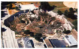
This huge hole is in Florida. It occurred when the surface suddenly collapsed because the land beneath it was being secretly eroded by groundwater. What do we call this?

1

crater

2

sinkhole

3

karsthole

4

pothole

Earth Science SOL Review Sheet #8 : 

Weathering and Erosion

Show answer

Auto Play

Slide 1 / 26

SLIDE