Understanding Ocean Exploration and Robotics
Interactive Video
•
Science, Biology, Geography
•
9th - 12th Grade
•
Practice Problem
•
Medium

Sophia Harris
Used 6+ times
FREE Resource
Read more
10 questions
Show all answers
1.
MULTIPLE CHOICE QUESTION
30 sec • 1 pt
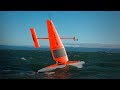
What is the primary propulsion method for the unmanned surface vehicle discussed in the video?
Nuclear power
Wind power
Diesel engines
Solar power
2.
MULTIPLE CHOICE QUESTION
30 sec • 1 pt
Why is ocean data considered scarce compared to land data?
There are fewer sensors available in the ocean
Land data is not as important as ocean data
Oceans are easier to study than land
Oceans are smaller than land areas
3.
MULTIPLE CHOICE QUESTION
30 sec • 1 pt
What is one of the main limitations of using satellites for ocean data collection?
They cannot cover large areas
They can only see through a small portion of the ocean surface
They provide data only during the day
They are too expensive to operate
4.
MULTIPLE CHOICE QUESTION
30 sec • 1 pt
What percentage of global CO2 is absorbed by the oceans?
20%
40%
10%
30%
5.
MULTIPLE CHOICE QUESTION
30 sec • 1 pt
What inspired the development of the ocean drone's wing concept?
Solar-powered vehicles
Wind-powered land yacht speed record
Aviation technology
Submarine design
6.
MULTIPLE CHOICE QUESTION
30 sec • 1 pt
What is the primary function of the ocean drones in the Bering Sea?
To measure ocean temperature
To track whale migrations
To assess the size of the pollock fish stock
To map the ocean floor
7.
MULTIPLE CHOICE QUESTION
30 sec • 1 pt
What technology do the ocean drones use to survey the fishing grounds?
Radar
Sonar
Infrared sensors
Lidar
Access all questions and much more by creating a free account
Create resources
Host any resource
Get auto-graded reports
Continue with Google

Continue with Email
Continue with Classlink
Continue with Clever
or continue with
Microsoft
%20(1).png)
Apple
Others
Already have an account?
