
 Worksheets
Earth Science Test Review
Total questions: 53
Worksheet time: 48mins
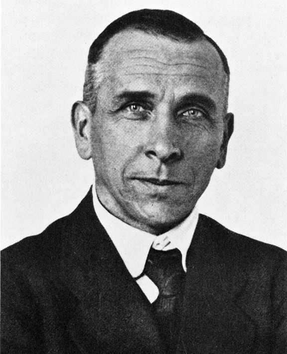
Who is the person credited with developing the theory of continental drift?
Harry Hess
Galileo
Alfred Wegener
Newton
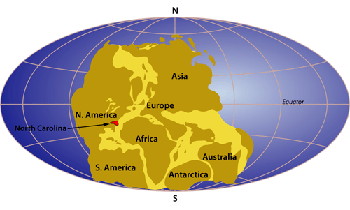
What is this a picture of?
plate tectonics
continental drift
pangea
glacier scaring
What does the theory of continental drift state?
The continents were once joined in a super-continent and have moved over time
Continents are stationary and do not move
The Earth is broken into lithospheric plates that move due to convection currents
none of the above
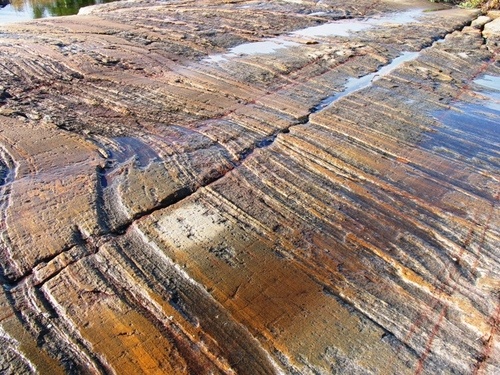
This is a picture of glacier scars found in Africa. What are these evidence for?
Africa has always been near the equator
Africa was once in an area of the Earth that had a very cold climate
The continents have not moved
sea floor spreading
What evidence did Wegener use in his theory?
Continents and fossils fitting together/matching-up like puzzle pieces
glacier scars and evidence from temperature
mountain ranges and coal deposits line up across continents
all of the above
Why did no one believe Wegener's thoery?
He could not explain HOW the continents moved
He didn't have evidence
His data was wrong
He didn't use the right technology to gather data
What was Wegener able to PROVE before his death?
The mid ocean ridge existed
convection currents cause plate movement
Greenland was moving away from Europe a tiny bit each year
Africa and South America were connected
The OLDEST seafloor is located?
Closest to the mid-ocean ridge
Farthest from the mid-ocean ridge
What kinds of evidence were used to prove that the seafloor spread?
Pillow lava, age of rocks, WWII shipwrecks
Age of rocks, magnetic seafloor stripes, WWII ship logs
Pillow Lava, magnetic seafloor stripes, age of rocks, SONAR
What technology was used during WWII to detect enemy submarines and produce the first map of the seafloor?
Sonar
Radar
GPS
Why do plates move?
Convection currents in the mantle cause plates to move.
The outer core spins
The inner core is magnetic
The plates are floating on an ocean
How are ridges formed?
Two plates collide with one another.
Two plates sink below Earth's surface.
Two plates slide beside each other.
Two plates move away from one another.
Which of the following explains how mountains are formed?
Plates collide at divergent boundaries causing the crust to push upward.
Plates collide at convergent boundaries causing the crust to push upward.
Plates slide past each other at transform boundaries causing the crust to push upward.
Plates collide at convergent boundaries causing the mantle to push upward
Why does oceanic crust sub-duct under continental crust?
The oceanic crust is more dense.
The oceanic crust is less dense.
The oceanic crust is hotter.
The oceanic crust is cooler.
When the sea floor spreads apart, ridges are formed because....
sediments are deposited where the sea floor spreads
as the plates pull apart, magma moves to the surface
ocean water pushes down on the surrounding sea floor
underwater earthquakes lift the sea floor into long ridges
The THICKEST sea floor is located?
Closest to the mid-ocean ridge
Farthest from the mid-ocean ridge
What is an earthquake?
A sudden movement of the Earth's crust caused by a release of stress accumulated along geological faults or by volcanic activity.
a. energy that builds up inside a volcanic mountain
a. energy being released when erosion occurs
a. molten rock pushing up through Earth's surface.

If plates move in the direction show in the picture, what will likely occur?
Mountain Formation
Earthquakes
Trench formation
Volcanic island formation

What type of plate boundary is shown in the picture?
convergent
divergent
transform

What type of boundary does the picture show and what does it form?
divergent; mountains
divergent; mid ocean ridge
convergent; mid ocean ridge
transform; earthquake

The map shows tectonic plate boundaries. The Himalayan Mountains are marked with an X. Which statement explains how the Himalayan mountains were formed?
Plate 1 and 4 Collided
Plate 1 and 2 Collided
Plate 1 and 4 Spread Apart
Plate 1 and 2 Spread Apart
Mount St. Helens is located near the boundary of the North American plate (continental) and the Juan de Fuca plate (oceanic). Which statement describes the plate movement for the formation of this volcano
The Juan de Fuca plate moves under the North American plate.
The Juan de Fuca plate moves away from the North American plate.
The North American plate slides past the Juan de Fuca plate
The North AMerican plate moves under the Juan de Fuca plate

Which land form is a fan-shaped deposit of sediment near the mouth of a river?
valley
basin
delta
mountain
When one tectonic plate __________ under another at a convergent boundary it sinks back in the mantle.
subducts
falls
sinks
A _____ will form on the ocean floor when becomes dense and sinks back towards the manrle
Earthquake
Rift Zone
Valley
Trench

Heat transfers within the Earth
Conduction
Convection Current
Ocean Current
Radiation

Plates sliding past each other in opposite directions
Convergent
Divergent
Subduction
Transform

Which was NOT evidence of Wegener?
Seafloor spreading
fossils
puzzle piece
glacier evidence
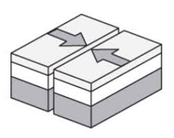
Name the boundary
convergent boundary
divergent boundary
transform boundary
sergent boundary
A collision between two pieces of continental crust at a converging boundary produces a
mid ocean ridge
deep ocean trench
rift valley
mountain range
The Himalayas in Asia are an example of what type of plate boundary?
divergent
continent-to-continent convergent
ocean-to-continent convergent
transform
When an oceanic plate and a continental plate collide, which one will subduct?
oceanic
continental
neither
A continental rift valley can be formed from stretching continental crust at...
transform plate boundaries
convergent plate boundaries
divergent plate boundaries
all plate boundaries
What geologic feature/event would you most likely to find at a divergent boundary between two pieces of oceanic crust?
Rift Valley
Mid-Ocean Ridge
Island Arc
Flat land
What geologic feature/event would you most likely to find at a divergent boundary between two pieces of continental crust?
Mid-Ocean Ridge
Mountain
Rift Valley
Island Arc
What geologic feature/event would you most likely to find at a convergent boundary between two pieces of continental crust?
Volcano
Mountain
Rift
Island Arc
What would you be most likely to find at a convergent boundary between two pieces of oceanic crust?
Mountains
Rift
Mid-Ocean Ridge
Island Arc
What would you be most likely to find at a convergent boundary between a continental and oceanic plate?
Folded Mountains
Volcanic Mountains and trenches
Mid-Ocean Ridge
Rift valleys
When two continental plates converge (collide) what type of crustal feature is formed?
Mid Ocean Ridge
Subduction Zone
Rift Valley
Folded Mountains

What is the elevation of point B?
800 ft
850 ft
900 ft
1000 ft

In which direction is Mill River flowing?
Southeast
Southwest
Northeast
Northwest
What do contour lines that are farther apart represent?
waterfall
steep area
gentle slope
river
It is steep on a topographic map where __________.
lines are closest together
a river flows into a lake
contours bend
contours are far apart

If sea level always equals (0), and the contour interval is 10 feet how tall is this mountain?
30 ft
40 ft
50 ft
60 ft

Match the topographic map to its profile picture.


What is the contour interval of the topographic map below?
400 m
200 m
100 m
80 m

If we were in a plane, Path B --> C is about the same distance as path E --> N. But, which path is the easier walk?
B --> C is the easier walk
E --> N is the easier walk
B --> C and E --> N are the same walking distance

What would be the most likely way this coastline would change over time?
A fire could destroy the vegetation
The waves could erode the beach
The beach would grow due to deposition
The beach will disappear due to plate tectonics

These images compare the same stretch of coastline. What is a possible reason for the change?
A fire destroyed the beach and surrounding area
Overtime, water eroded away much of the land
A major catastrophe such as a hurricane or tsunami destroyed the area
The beach and land went through a sever drought

A satellite image of an area in Florida shows a river with slight bends along its length. A second satellite image taken of the same area 10 years later shows the same river with a different course. What is the best explanation for the difference in the shape of the river's course between the two satellite images?
Wind blew waves across the water surface, eroding away the bank on one side of the river until the river's course changed its shape
Regular freezing and thawing of the river split the soil along the river banks, changing the shape of the river
Water eroded the banks of the river and deposited the eroded soil on opposite banks, causing the river to form tighter bends
Acid rain chemically weathered the banks along the river, forcing the river to wind back and forth

The image below represents a satellite view. What type of land features are pictured in this image?
canyons
hills
rivers
volcanoes

What is the map symbol (darker lines)?
roads
index contour
contour interval
waves

What is the difference in elevation between Point X and Point Y?
120 m
240 m
360 m
340 m

