wayground logo

Free Printable Worksheets

Font size

S
M
L
XL
Worksheets

Topographic Maps

Total questions: 134

Worksheet time: 3hrs 47mins

Name
Class
Date
1.
Determine the contour interval:
a)
5 m
b)
10 m
c)
15 m
d)
20 m
2.

Maps that show shape and elevation of the Earth's surface

a)

physical map

b)

topographic map

c)

road map

d)

historical map

3.

the height above sea level

a)

key

b)

scale

c)

elevation

d)

contour lines

4.

The curved lines on a topographic map

a)

contour lines

b)

longitude lines

c)

latitude lines

d)

map scale

5.

What does this picture represent?

a)

A depression

b)

hilltop

c)

gentle slope

d)

steep slope

6.

What does this picture represent?

a)

steep slope

b)

gentle slope

c)

a depression

d)

a hilltop

7.
Find the contour interval:
a)
10 ft
b)
20 ft
c)
25 ft
d)
100 ft
8.
Which direction is the river flowing?
a)
north
b)
south
c)
east 
d)
west
9.
The bold lines that appear on the map every 5th contour line with the exact elevation written on it is the ______________________
a)
Index Contour line
b)
Contour interval
c)
Relief
d)
Slope
10.
How many mountain tops does this map have?
a)
one
b)
two
c)
three
d)
four
11.

What is the elevation of point c?

a)

800 ft

b)

850 ft

c)

1500 ft

d)

1000 ft

12.
Which direction is the river flowing?
a)
north
b)
south
c)
east 
d)
west
13.

If sea level always equals (0), and the contour interval is 10 feet how tall is this mountain?

a)

30 ft

b)

40 ft

c)

50 ft

d)

60 ft

14.

Which side is steeper?

a)

The left side of the hill

b)

The right side of the hill

15.

What is the contour interval?

a)

1 ft

b)

5 ft

c)

10 ft

d)

60 ft

16.
Topographic maps provide information about the size, shape, and 
a)
elevation
b)
dimension 
c)
average 
17.
Each contour line is used to connect points that have the same elevation, therefore, they 
a)
Always cross
b)
Never cross 
18.
Lines on a topographic map that connect lines of equal elevation:
a)
contour lines
b)
contour interval
c)
index contour
d)
contour loops 
19.
What is the elevation of point B?
a)
800 ft
b)
850 ft
c)
900 ft
d)
1000 ft
20.

In which direction is Mill River flowing?

a)

Southeast

b)

Southwest

c)

Northeast

d)

Northwest

21.
What is the elevation of Y?
a)
Between 120-140 meters
b)
Between 100-120 meters
c)
Between 140-160 meters
d)
Between 80-100 meters
22.
The distance from D to E is...
a)
A little over 2 km
b)
A little over 3 km
c)
A little over 4 km
d)
A little over 5 km
23.
What is the elevation of the peak of the small island on the left side?
a)
About 20 meters
b)
About 40 meters
c)
About 60 meters
d)
About 200 meters
24.
What is the elevation of A?
a)
10 meters
b)
20 meters
c)
40 meters
d)
120 meters
25.
What feature is formed at B?
a)
river
b)
rift valley
c)
sink hole
d)
mountain
26.
If we were in a plane, Path B --> C is about the same distance as path E --> N. But, which path is the easier walk? 
a)
B --> C is the easier walk
b)
E --> N is the easier walk
c)
B --> C and E --> N are the same walking distance
27.
What feature is at the arrow?
a)
volcano
b)
mountain
c)
cliff
d)
river
28.
What do contour lines that are farther apart represent?
a)
waterfall
b)
steep area
c)
gentle slope
d)
river
29.
What is the difference in elevation between Point X and Point Y?
a)
120 m
b)
240 m
c)
360 m
d)
340 m
30.
Provided is a topographic map of a hill with contour lines drawn showing elevation in meters.
The steepest slope on this hill can be found on the side that is facing which direction?
a)
Southwest
b)
Northeast
c)
Northwest
d)
Southeast
31.
Look at the arrow.  What could this feature be?
a)
depression
b)
volcano
c)
sinkhole
d)
any of these are possible
32.
In which direction is Mill River flowing?
a)
Southeast
b)
Southwest
c)
Northeast
d)
Northwest
33.
What is the elevation of Y?
a)
Between 120-140 meters
b)
Between 100-120 meters
c)
Between 140-160 meters
d)
Between 80-100 meters
34.
What is the highest elevation on this map?
a)
Over 320 meters
b)
Over 450 meters
c)
Over 220 meters
d)
Over 380 meters
35.

What is the contour interval for this map?

a)

500

b)

100

c)

20

d)

1000

36.

What is the contour interval?

a)

100

b)

10

c)

20

d)

50

37.
Determine the contour interval:
a)
5 m
b)
10 m
c)
15 m
d)
20 m
38.
Which direction is the river flowing?
a)
north
b)
south
c)
east 
d)
west
39.
In which direction is Mill River flowing?
a)
Southeast
b)
Southwest
c)
Northeast
d)
Northwest
40.
What is the map symbol (darker lines)?
a)
roads
b)
index contour
c)
contour interval
d)
waves
41.
It is steep on a topographic map where __________.
a)
lines are closest together
b)
a river flows into a lake
c)
contours bend
d)
contours are far apart
42.
What is the elevation of A?
a)
10 meters
b)
20 meters
c)
40 meters
d)
120 meters
43.
What is the map symbol (darker lines)?
a)
roads
b)
index contour
c)
contour interval
d)
waves
44.
Determine the contour interval
a)
10 m
b)
20 m
c)
50 m
d)
100 m
45.
What is this symbol?
a)
mountain
b)
depression or sinkhole
c)
cave
d)
railroad central
46.
What does this image represent?
a)
mountain
b)
depression or sinkhole
c)
beaches
d)
cave
47.
Lines on a topographic map that connect lines of equal elevation:
a)
contour lines
b)
contour interval
c)
index contour
d)
contour loops 
48.
When you move from one contour line to another, the elevation
a)
stays the same
b)
goes up or down
c)
disappears
d)
is below sea level
49.
On a topographic map of a mountain, you walk a longer distance to get to the top when the contour lines are
a)
spread out
b)
close together
c)
going down
d)
going up
50.
Water flows fastest when
a)
there is a steep slope
b)
there is a gentle slope
c)
there is a long distance
d)
it has to move around boulders
51.
A mountaineer is planning an expedition. He wants to follow the easiest possible path, which means he needs to find the most gentle slope up the mountain. Which route should the mountaineer choose?
a)
Route A
b)
Route B
c)
 Route C
d)
Route D
52.
Determine the contour interval
a)
10 m
b)
20 m
c)
50 m
d)
100 m
53.
Determine the contour interval:
a)
5 m
b)
10 m
c)
15 m
d)
20 m
54.
What do close contour lines represent on a map?
a)
waterfall
b)
steep area
c)
gradual area
d)
river
55.

What is the contour interval?

a)

500

b)

20

c)

100

d)

1000

56.

What are the contour intervals of the map?

a)

100

b)

55

c)

50

d)

150

57.

How many mountains are in this picture?

a)

1

b)

2

c)

3

d)

4

58.

What is the approximate elevation of Hu?

a)

3000

b)

2000

c)

2500

d)

500

59.

What are the contour line intervals?

a)

100

b)

200

c)

1000

d)

2000

60.

A topographic map is a

a)

map that shows the Earth's decline over time

b)

map that shows the location of trees, bushes and flowers

c)

map that shows the changes in elevation of the Earth surface

d)

map that shows the location of buildings and houses

61.

Index contours are marked by a

a)

number representing the gradient

b)

number representing the distance between two points

c)

number representing the maps total elevation

d)

number representing the elevation at that line

62.

The further the lines = STEEPER slope

a)

true

b)

false

63.

What does this symbol on a topographic map mean?

a)

depression (going down)

b)

hilltop

c)

train tracks

d)

valley

64.

Which side of the hill would be hardest to climb?

a)

South side

b)

East side

c)

North side

d)

West side

65.

What feature do these V-shaped contour lines represent?

a)

cliff

b)

peak

c)

hill

d)

river

66.
What is the elevation of point B?
a)
800 ft
b)
850 ft
c)
900 ft
d)
1000 ft
67.
Which of the following pairs is correctly matched?
a)
6 and F
b)
1 and A
c)
1 and B
d)
2 and C
68.
Find the contour interval:
a)
5 ft
b)
10 ft
c)
20 ft
d)
25 ft
69.
Which topographic map matches formation C?
a)
1
b)
2
c)
3
d)
4
70.
Based on the map below, which location has a greater elevation, A or B?
a)
Location A is higher.
b)
Location B is higher.
c)
Locations A and B are at the same elevation.
d)
It is impossible to determine which location is higher.
71.

The picture shows the Marble Canyon, a section of the Grand Canyon. What formed this canyon?

a)

the rushing movement of water from a river over millions of years, showing evidence of one way Earth's landscape has naturally evolved

b)

the subduction of plate boundaries, showing how the movement of plate boundaries is the only way that Earth's landscape evolves over time

c)

the movement of ice along Earth's surface, showing that Earth's surface did not change until ice was present

d)

the rapid evaporation of the river over a short period of time, showing how adaptive Earth's surface is when the environment changes

72.
Which best describes how deltas are formed?
a)
Slow moving water picks up sediment and deposits it at the mouth of the river when the river speeds up.
b)
Fast moving water picks up sediment and deposits it at the mouth of the river when the river slows down.
c)
Slow moving water picks up sediment and deposits it at the base of the mountain when the slope is steeper.
d)
Fast moving water picks up sediment and deposits it at the base of the mountain when the slope is gentle.
73.
What would be the most likely way this coastline would change over time?
a)
A fire could destroy the vegetation
b)
The waves could erode the beach
c)
The beach would grow due to deposition
d)
The beach will disappear due to plate tectonics
74.
The image below represents a satellite view. What type of land features are pictured in this image?
a)
canyons
b)
hills
c)
rivers
d)
volcanoes
75.
Which point on the map would be the flattest area?
a)
A
b)
B
c)
C
d)
D
76.
Look at the following image and explain how the land formation was created.
a)
This shows that the sea level is slowly increasing due to precipitation being greater than the rate of evaporation.
b)
This shows that the sea level is slowly decreasing due to the precipitation  being less than the rate of evaporation.
c)
This shows a delta forming because the rate of deposition is greater than the rate of erosion.
d)
This shows an alluvial fan formed because deposition is less than the rate of erosion.
77.
Deltas are built up by -
a)
deposition
b)
leaching
c)
abrasion
d)
erosion
78.
Name this boundary
a)
Convergent
b)
Divergent
c)
Transform
d)
Sergent
79.
Name the boundary
a)
divergent
b)
convergent
c)
transform
d)
sergent
80.
Name the boundary
a)
convergent
b)
transform
c)
divergent
d)
sergent
81.
Which of the following is associated with transform boundary?
a)
volcanoes
b)
mountains
c)
trenches
d)
earthquakes and fault line
82.
Which of the following land formation occurs at a divergent continental/continental boundary?
a)
mid-ocean ridge
b)
deep ocean trench
c)
Pacific hot spot
d)
rift valley
83.
Mountains form from....
a)
Plates sliding past one another
b)
collision of plates
c)
plates moving away from each other
d)
none of these
84.

Describe the most likely relationship between these mountains and nearby tectonic plates.

a)

The mountains are probably formed by earthquakes

b)

The mountains are probably formed by the movement of glaciers

c)

The mountains are probably located near the edge of 2 tectonic plates.

d)

The mountains are probably formed by running water.

85.

Is there a pattern to the locations of earthquakes and volcanoes around the globe?

a)

No, earthquakes and volcanoes are random.

b)

Yes, earthquakes and volcanoes usually occur near the boundaries of tectonic plates.

c)

yes, earthquakes and volcanoes usually occur in the middle of tectonic plates.

d)

No, earthquakes and volcanoes usually occur under water.

86.

Most earthquakes tend to occur at which location?

a)

The central regions of very large continents

b)

Groups of islands farthest from any continents

c)

The boundaries between continents and oceans

d)

The steep slopes of the very oldest mountains

87.

A map is provided that presents information on a certain region of the Earth. Based on the information on the map, at which location are mountains most likely to form?

a)

A

b)

B

c)

C

d)

D

88.

A map is provided that shows the location of the Aleutian Islands in comparison to some of Earth’s tectonic plates is provided. Based on the information provided, which of the following is most likely a feature of the Aleutian Islands?

a)

The climate is getting older.

b)

They were formed by volcanic activity.

c)

These islands are the oldest on Earth.

Earthquakes do not occur there

89.

A force caused the continents to drift apart over time. Once scientists figured out what that force was, the theory of plate tectonics was born! The image above shows what Geologists think the Earth looked like millions of years ago. What name was given to this land mass.

a)

Plate Tectonics

b)

Oceana

c)

Pangea

d)

North America

90.

A force caused the continents to drift apart over time. Once scientists figured out what that force was, the theory of plate tectonics was born! The image above shows what Geologists think the Earth looked like millions of years ago. What name was given to this land mass.

a)

Plate Tectonics

b)

Oceana

c)

Pangea

d)

North America

91.

Peru and Chile are part of South America, which sits on the South American tectonic plate. The Nazca plate is moving toward the South American plate. It is pushed downward, which causes it to slide under the South American plate. Based on this information, what feature could we expect to see off the coast of Peru and Chile?

a)

new Continent formation

b)

Poor fishing conditions

c)

Deep ocean trench

d)

Severe tropical storms

92.

Tectonic plates float on top of the ________

a)

Crust

b)

Mantle

c)

Inner Core

d)

Outer Core

93.

We live in an area without many earthquakes because _____

a)

We live near a major fault line

b)

We live near the boundary of 2 tectonic plates

c)

We live near the middle of the North American Plate

d)

We live near the Pacific Plate

94.

Look at the drawing shown. What likely happens when two continental plates collide?

a)

An ocean trench forms.

b)

Earthquakes occur.

c)

Sea-floor spreading occurs.

d)

Folded mountains form.

95.

Look at the picture. Which event is most likely to occur at the location shown based on the movement of the plates?

a)

volcanic eruption

b)

mountain building

c)

earthquake

d)

new crust formation

96.

Which of the following answers lists events that result from the motion of tectonic plates?

a)

hurricanes and tropical depressions

b)

ocean currents

c)

high tides and low tides

d)

earthquakes and mountain building

97.

Which of the following statements describes a tectonic plate?

a)

a continent or an ocean

b)

the outermost compositional layer of Earth

c)

a block of the lithosphere that moves around on top of the asthenosphere

d)

the structural layer of Earth that is made of the crust and the rigid, upper part of the mantle

98.

Look at the picture. Which event is most likely to occur at the location shown based on the movement of the plates?

a)

volcanic eruption

b)

mountain building

c)

earthquake

d)

new crust formation

99.

What is an elongated valley formed by the depression between two faults

a)

mountain formation

b)

volcano

c)

rift valley

d)

earthquake

100.

An illustration of the major tectonic plates is provided. Which of the labeled plates in the illustration is the Eurasian Plate?

a)

A

b)

B

c)

C

d)

D

101.

The interaction of tectonic plate boundaries is associated with which of the following events?

a)

Hurricanes

b)

Tropical Storms

c)

Earthquakes

d)

Tornados

102.

At which type of plate boundary will a trench most likely form?

a)
b)
c)
d)
103.

An illustration of the major tectonic plates is provided below. Which of the labeled plates is the North American Plate?

a)

Plate A

b)

Plate B

c)

Plate C

d)

Plate D

105.

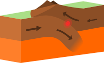
An ocean basin will form in what location, relative to the major tectonic plates?

a)

At plate boundaries where friction occurs

b)

In the center of the largest plates

c)

On a plate pushed up by another plate

d)

Where two plates pull apart
105.

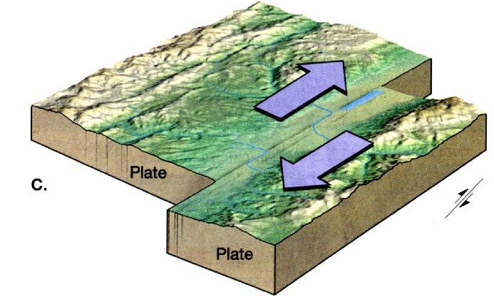
An ocean basin will form in what location, relative to the major tectonic plates?

a)

At plate boundaries where friction occurs

b)

In the center of the largest plates

c)

On a plate pushed up by another plate

d)

Where two plates pull apart
106.
Name the boundary
a)
divergent
b)
convergent
c)
transform
d)
sergent
107.
Sand Andreas Fault formed at this type of boundary-
a)
Transform Boundary
b)
Convergent Boundary
c)
Divergent Boundary
d)
Hot Spot
108.
Name the boundary
a)
divergent
b)
convergent
c)
transform
d)
sergent
109.
This is an example of -
a)
convergent
b)
divergent
c)
transform
110.
This is an example of -
a)
convergent
b)
divergent
c)
transform
111.
This is an example of -
a)
convergent
b)
divergent
c)
transform
112.
This is an example of -
a)
convergent
b)
divergent
c)
transform
113.
This image represents this type of boundary
a)
divergent
b)
transform
c)
convergent
d)
tectonic
114.
The movement of plates at a divergent boundary
a)
move towards each other
b)
slide past each other
c)
move up and down
d)
move away from each other
115.
The movement of plates at a divergent boundary
a)
move towards each other
b)
slide past each other
c)
move up and down
d)
move away from each other
116.
 A land feature that is produced at a convergent boundary is
a)
a valley
b)
an ocean
c)
a canyon
d)
a volcano
117.
This layer of Earth is the thickest part
a)
crust
b)
outer core
c)
mantle
d)
inner core
118.
What are the two types of crust
a)
continental and oceanic
b)
ocean and upper
c)
lower and upper
d)
pizza and subway
119.
What is the name of the area where one crust slides underneath another
a)
no flex zone
b)
subduction zone
c)
transverse zone
d)
school zone
120.
Sea floor spreading happens at what type of boundary
a)
Divergent
b)
Convergent
c)
Transform
d)
Mountainous
121.
This image is of...
a)
Transform Boundary
b)
Convergent Boundary
c)
Divergent Boundary
122.
When two tectonic plates converge, one being an oceanic plate and the other a continental plate, what is generated above sea level?
a)
mountain ranges 
b)
landslides
c)
tsunamis
123.
Earth's crust is constantly being recycled.  New crust is formed when molten rock comes to the surface and is cooled.
a)
True
b)
False
124.
A deep valley that forms along a subduction zone-
a)
an earthquake
b)
a volcano
c)
a trench
125.
What type of event will occur at this boundary?
a)
Earthquake
b)
Volcano Eruption
c)
Tornado
d)
Mountain Building
126.
What type of plate boundary is this?
a)
Plate
b)
Divergent
c)
Convergent
d)
Transform
127.
What type of plate boundary is this?
a)
Transform
b)
Convergent
c)
Divergent
d)
Plate
128.
The Great Rift Valley in Africa and the Mid-Ocean Ridge were all created by this boundary
a)
Divergent
b)
Convergent
c)
Reform
d)
Transform
129.
The area where two tectonic plates meet.
a)
mantle
b)
focus
c)
plate boundary
d)
convection
130.
Most volcanoes and earthquakes occur...
a)
along the coast
b)
along tectonic plate boundaries
c)
in the Arctic
d)
in the ocean
131.
This landform can occur at a divergent plate boundary.
a)
ocean trench
b)
mid-ocean ridge
c)
tall mountains
d)
transform fault
132.

What was Alfred Wegener's theory called?

a)

one earth

b)

jigsaw puzzle moves

c)

continental drift

d)

none of the above

133.

What is the name given to the one "Super continent"?

a)

Pangaea

b)

Superuno

c)

eine Welt

d)

Derosen

134.

Under sea mountain ranges are called:

a)

deep sea trench

b)

aquatic ranges

c)

mid-ocean ridges

d)

salty hills