
 Worksheets
Climate
Total questions: 80
Worksheet time: 52mins

Objects in the NORTHERN Hemisphere deflect to which direction due to the Coriolis Effect?
Left
Up
Down
Right
Objects in the SOUTHERN Hemisphere deflect to which direction due to the Coriolis Effect?
Left
Up
Down
Right
The driving force of the Water Cycle is?
The troposphere
The Sun
The oxygen
The clouds
Which winds were crucial to sailors because it helped them get their items across the ocean to sell?
Trade Winds
Prevailing winds
Westerlies
Jet Stream
Westerlies blow in which direction?
West to East
North to South
South to North
East to West
Easterlies blow in which direction?
East to West
North to South
South to North
West to East
Narrow bands of strong winds that blow near the top of the troposphere are referred to as what?
Jet Streams
Cirrus Clouds
Easterlies
Sea Breeze
The windless, rainy zone near the equator is called the what?
Doldrums
Easterlies
Tropics
Jet Stream
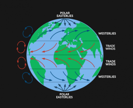
what is the coriolis effect?
change in location of warm and cold surface water every 2-7 years
tendency of objects moving large distances on Earth’s surface to bend to the right in the northern hemisphere & to the left in the southern hemisphere
winds in northern Indian ocean that blow from the southwest in the summer & from the northeast in winter
two layers of horizontal winds moving in opposite directions
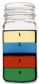
______ causes deep ocean currents
The Coriolis Effect
gravity
wind
density differences
Which of the following best explains the concept of salinity?
It's how much matter is found in an object.
It's how much space an object takes up.
It's how much salt is in a substance.
It's how much water is in salt.
_______are daily changes in ocean water.
Waters
Tides
Colors
Earths


Which location is warmer: Los Angeles or N'Djamera?
Los Angeles
N'Djamera
The reason why it is so hot near the equator is ___.
the sun heats the lava under that area
the area near the equator gets lots of indirect sunlight
the area near the equator gets lots of direct sunlight
the light near that area is shy


What factor is influencing the temperature of these two cities
Latitude
Altitude
Distance from Large Body of Water
Ocean Currents
Fill in the blank: The higher the altitude, the ______ the temperature.
warmer
colder
An El Nino event occurs when the tropical ocean surface waters are warmer in which ocean?
Atlantic
Indian
Pacific
Arctic
How could La Niña affect weather during the summer in Georgia?
It could decrease wind.
It could increase rainfall.
It could decrease rainfall.
It could increase temperatures.

Which climograph has the most precipitation during the winter?
A
B
C
D

When is there the most precipitation & highest temperatures?
February
July
September
December

Is the Earth heated evenly?
Yes
No

The Coriolis Effect causes which two things to curve sideways?
weather and climate
wind and ocean currents
rain and snow
temperatures

Cities that are closer to large bodies of water tend to have _____________ temperatures
more extreme temperature changes
less extreme temperature changes
4 distinct seasons
more sunshine

What is the name of the ocean currents that are caused by a difference in temperature?
hot water
surface currents
convection currents
hurricanes
Surface currents are mainly driven by _________________.
sun
wind
temperature
narwhals
Cause of Deep currents
Thermohaline circulation
Coriolis effect
Which would sink to the bottom of the ocean?
water with high salt content
water with high temperature
water with low density
water with low salt content
________ and _______ affect the ocean's density and cause the Global Conveyor Belt to travel
gravity and the Coriolis Effect
temperature and salinity
wind and climate
temperature and the Coriolis Effect

Winds occur because hot air rises and cool air sinks in a process called...
conduction
convection
radiation
magnetism
Cool, dense air ___.
RISES
SINKS
Warm, less-dense air from areas like the Equator form areas of _______ pressure.
HIGHER
LOWER

area of slow moving winds located between the prevailing westerlies and trade winds around 30° latitude in both hemisphere
doldrums
horse latitudes
trade winds

What landform causes the rain shadow effect?
Mountains
Lakes
Plains
Valleys

Review the image and answer the following question.
In the western United States, most rain shadows occur on what side of the mountain ranges?
The west side of the mountain
The Southern Part of a mountain
The Northern part of a mountain
The Eastern part of a mountain

Which statement is true about air's capacity to hold water?
As air rises higher up the mountain, its capacity to hold water vapor decreases
As air rises higher up the mountain, its capacity to hold water vapor increases
As you go to the top of a mountain, what happens to the air temperature?
nothing
it decreases
it increases
it fluctuates between warm and cold

What is a rain shadow?
A region that receives high precipitation due to topography
A region that receives low precipitation due to topography
Most moisture falls on the _________ side.
leeward
windward
rain shadow
altitude
1. Some mountains located near the Earth's Equator have snow-covered peaks.
2. Icecaps exist at the Earth's poles.

The curved paths of the planetary winds are a result of
Because of the Earth's rotation, ocean currents run
in straight lines
up and down
in circular motions
out
The coldest regions on earth are the ________________.
Poles
Tropics
deserts
rain forests
The warm, low latitude regions near the Equator both north and south are called the -
Poles
Tundra
Tropics
Arctic
Intensity of temperature depends on
latitude
longitude
altitude vegetation
altitude vegetation

What are these circles on the above image?
longitudes
latitudes
hemispheres
grids

You hike up a mountain that is very rainy and has a lot of trees on it. What side of the mountain are you on?
windward side
leeward side

Which temperature zone gets the MOST direct energy from the sun?
tropical
polar

Seattle, Washington is located on the windward side of the Cascade Mountains and Spokane, Washington is located on the leeward side. Which location is COLDER with MORE RAIN?
Spokane because it's on the leeward side
Seattle because it's on the windward side

Miami, Florida gets more rain than Sabha, Libya. Why?
because it is close to the ocean
because it is NOT close to an ocean

The lower the elevation the __________ the temperature.
Cooler
Hotter
______________________ carry warm waters away from the equator that distribute mild humid climates across the Earth's surface.
Sea birds
Rubber ducks
Ocean currents
Mountains
__________________ carry climate-impacting air conditions (warm, cool, humid, dry) from one region to another region.
Winds
Peninsulas
Longitudes
Sea birds
The closer you are to the ocean the:
more moderate the climate
climate will be hotter in summer and colder in winter
more variety of vegetation and climate you will find
more extreme the weather
Prevailing winds around the equator cause warm, moist air to rise, forming clouds and causing high rainfall.
True
False
Why are temperature variations usually not as great on Ocean City as they are in western Maryland?
western Maryland has a higher elevation.
western Maryland is more heavily wooded.
Ocean City has a more southerly latitude.
Ocean City is surrounded by a large body of water.


Which of these IS NOT a name for a Global Wind Belt?
Trade Winds
Horse Latitudes
Jet Stream
Polar Easterlies
Prevailing Westerlies

