Wayground logo

Free Printable Worksheets

Font size

S
M
L
XL
Worksheets

U6- Weather and Climate TEST

Total questions: 103

Worksheet time: 2hrs 31mins

Name
Class
Date
1.
Surface currents are a result of
a)
Global Wind Patterns
b)
Earth's Rotation
c)
Density
d)
All of the above
2.

_______ causes the Coriolis Effect

a)

Earth's rotation

b)

gravity

c)

wind

d)

density

3.
Which of these is NOT a factor that determines the climate of a place?
a)
latitude
b)
wind patterns
c)
longitude
d)
elevation
4.
Which sentence best describes the relationship between elevation and air temperatures?
a)
 LOWER elevation = COLDER temperatures
b)
HIGHER elevation = COLDER temperatures
c)
HIGHER elevations = WARMER temperatures
d)
There is no relationship
5.

The seasons are caused by___________?

a)

The amount the Earth's axis is tilted toward the sun

b)

Changing distance between the poles and sun

c)

Changes in the moon

d)

The Earth's rotation on its axis

6.
In which position is it Spring in the Northern Hemisphere?
a)
1
b)
2
c)
3
d)
4
7.

What does "latitude" refer to?

a)

the distance away from the Equator

b)

how much rain a place gets

c)

how high up a mountain a place is

d)

the number of seasons a place gets

8.

The Coriolis Effect causes which two things to curve sideways?

a)

weather and climate

b)

wind and ocean currents

c)

rain and snow

d)

temperatures

9.

Cities that are closer to large bodies of water tend to have _____________ temperatures

a)

more extreme temperature changes

b)

less extreme temperature changes

c)

4 distinct seasons

d)

more sunshine

10.
The sun's rays are least direct
a)
near the poles
b)
near the equator
c)
at high altitude
d)
far from the ocean
11.
Increased carbon dioxide may cause global warming by trapping more ____________ in the atmosphere.
a)
water
b)
gases
c)
heat
d)
water vapor
12.

Melting Arctic sea ice causes oceans to warm because...

a)

water has a higher specific heat than ice

b)

water has a higher albedo

c)

water has a lower specific heat than ice

d)

water has a lower albedo

13.

Which reason best explains why the west coast of South America is a desert?

a)

it is at 30oS latitude

b)

warm ocean currents by the coast

c)

the rainshadow effect

d)

melting glaciers in the Andes mountains

14.

Solar energy is most direct at ____ in December.

a)

the south pole

b)

the tropic of capricorn (23.5S)

c)

the equator

d)

the tropic of cancer (23.5N)

15.
What is the best explanation for these two statements?
1. Some mountains located near the Earth's Equator have snow-covered peaks. 
2. Icecaps exist at the Earth's poles.
a)
High elevation and high latitude have a similar effect on climate. 
b)
Both mountain and polar regions have arid climates.
c)
Mountain and polar regions receive more energy from the Sun than other regions.
d)
An increase in snowfall and an increase in temperature have a similar effect on climate. 
16.
A city located near the center of a large continent has colder winters and warmer summers than a city at the same elevation and latitude located on the continent's coast. Which statement best explains the difference between the cities climates? 
a)
Windspeeds are greater over land than over oceans. 
b)
Air masses originate only over land. 
c)
Land has a lower specific heat than water.
d)
Water changes temperature more rapidly than land. 
17.
At which latitudes do currents of dry, sinking air cause the dry conditions of Earth's major deserts?
a)
0° and 30°N
b)
60°N and 60°S
c)
30°N and 30°S
d)
60°S and 90°S
18.
Which statement best explains why a desert often forms on the leeward side of a mountain? 
a)
Sinking air compresses and warms.
b)
Sinking air expands and warms.
c)
Rising air compresses and warms.
d)
Rising air expands and warms. 
19.
The planetary winds on Earth are indicated by the curving arrows in the diagram. 
The curved paths of the planetary winds are a result of 
a)
changes in humidity.
b)
changes in temperature.
c)
Earth's rotation on its axis
d)
Earth's gravitational force
20.

The diagram shows an imaginary continent on Earth surrounded by water. The arrows indicate the direction of the prevailing winds. Two large mountain regions are also indicated. Points A, B, C, and H are located at sea level; C, D, and F are in the hills of the mountains; G is high in the mountain. THIS DIAGRAM IS FOR THE NEXT 4 QUESTIONS


Which location probably has the greatest annual rainfall?

a)

A

b)

F

c)

C

d)

D

21.
Which physical characteristics would cause location G to have a colder yearly climate than any other location?
a)
the nearness of location G to a large ocean
b)
the location of G with respect to the prevailing winds
c)
the elevation of location G above sea level
d)
the distance of location G to the equator
22.
Which location probably has the greatest range in temperature during the year? 
a)
A
b)
B
c)
H
d)
D
23.

The first diagram shows an imaginary continent on Earth surrounded by water. The arrows indicate the direction of the prevailing winds. Two large mountain regions are also indicated. Points A, B, C, and H are located at sea level; C, D, and F are in the hills of the mountains; G is high in the mountain.

Which graph shows best represents the average monthly temperature that would be recorded during one year at location E?

a)

1

b)

2

c)

3

d)

4

24.

If an area has a very cold climate, it is most likely that the area

a)

is close to the equator.

b)

will support tropical plants.

c)

does not get much sunlight.

d)

is close to the ocean.

25.

The equator tends to contain regions with hot climates. However, the Rwenzori Mountains, which are located close to the equator, are covered in ice caps.

Why is the climate of the Rwenzori Mountains not hot?

a)

Regions away from the ocean are cooler.

b)

Clouds form a cold blanket over the mountains.

c)

The mountains block radiation from the Sun.

d)

Temperatures decrease with elevation.

26.

In which of the following ways can mountains influence climate?

a)

Mountains have a higher elevation than surrounding areas. Because these areas are closer to the sun, they enjoy a warmer climate.

b)

Mountains have no affect on the climate of an area.

c)

Mountains cause air to rise. The rising air cools, resulting in condensation and precipitation.

d)

Mountains interfere with moving air. The air moves up the mountain, and circles back down, eventually causing tornadoes.

27.

Which of the following best explains why the latitude of a region influences its climate?

a)

The latitude of a region determines its proximity to the ocean.

b)

The latitude of a region determines the land forms present in the area.

c)

The latitude of a region determines how much sunlight the area receives.

d)

The latitude of a region determines its elevation above sea level.

28.

Which of the following factors would affect the weather patterns of a region?

a)

nearby bodies of water

b)

altitude

c)

latitude

d)

all of these

29.

What part of the climate do global winds affect?

a)

Temperature

b)

Precipitation

30.

What part of the climate does topography, or the shape of the land, affect?

a)

Temperature

b)

Precipitation

31.

Prevailing winds in the United States go from ____ to ______.

a)

east to west

b)

north to south

c)

west to east

d)

south to north

32.

Identify the factor that influence the temperature of these two areas

a)

Latitude

b)

Elevation

c)

Distance from Large Bodies of Water

d)

Ocean Currents

33.

What factor is influencing the temperature of these two cities

a)

Latitude

b)

Elevation

c)

Distance from Large Body of Water

d)

Ocean Currents

34.

Which BEST describes why latitudes closest to the equator have warmer climates?

a)

they are at lower elevations

b)

they receive high angle sunlight

c)

they are nearer to ocean currents

d)

they get more winds that carry energy in the form of heat

35.
Winds that blow from the west are called ____.
a)
Easterlies
b)
Polars
c)
Westerlies
d)
Temperates
36.
The sun’s rays are least direct __________.
a)
near the poles.      
b)
in July.
c)
near the equator.
d)
far from the ocean.
37.
Two factors to determine climate are
a)
precipitation and temperature
b)
hurricanes and tornadoes
c)
humidity and pressure
38.

Why is the Equator warmest?

a)

Because it is closest to the sun.

b)

Because it receives the most direct sunlight

c)

Because no clouds form here.

d)

Because it is far from the sun

39.

Any changes to the overall climate of the Earth over several years is ___________ _____________.

a)

greenhouse gasses

b)

climate change

c)

carbon dioxide

d)

nitrous oxide

40.

What does this graph tell us?

a)

This graph tells us that the earth is in a cooling trend

b)

This graph tells us that the CO2 in the atmosphere is falling right now

c)

This graphs shows us that when the CO2 levels go up, the earth's temperature goes up.

d)

This graph shows us the Keeling Curve

41.
Which of the following are greenhouse gases?
a)
Carbon dioxide
b)
Methane
c)
Water vapor
d)
All answers are correct
42.

Where do MARITIME air masses form?

a)

Over water

b)

Over land

43.

Where do CONTINENTAL air masses form?

a)

Over water

b)

Over land

44.

Which type of air mass brings WARM and DRY weather?

a)

Maritime Polar (mP)

b)

Maritime Tropical (mT)

c)

Continental Polar (cP)

d)

Continental Tropical (cT)

45.

Which type of air mass brings WARM and WET weather?

a)

Maritime Polar (mP)

b)

Maritime Tropical (mT)

c)

Continental Polar (cP)

d)

Continental Tropical (cT)

46.

Which type of air mass bring COLD and DRY weather?

a)

Maritime Polar (mP)

b)

Maritime Tropical (mT)

c)

Continental Polar (cP)

d)

Continental Tropical (cT)

47.

Which air mass would be classified as Maritime Polar (mP)?

a)

purple

b)

green

c)

blue

d)

yellow

e)

red

48.

Which air mass would be classified as Maritime Tropical (mT)?

a)

purple

b)

green

c)

blue

d)

yellow

e)

red

49.

Which air mass would be classified as Continental Tropical (cT)?

a)

purple

b)

green

c)

blue

d)

yellow

e)

red

50.

Which air mass would bring warm and wet weather?

a)

purple

b)

green

c)

blue

d)

yellow

e)

red

51.

Which air mass is higher in humidity?

a)

purple

b)

blue

52.

Which air mass is warmer?

a)

red

b)

yellow

53.
Albedo can best be described as...
a)
the temperature at the equator
b)
the amount of solar radiation absorbed
c)
the amount of solar radiation reflected
d)
the air pressure during El Nino
54.
What has the highest albedo?
a)
the oceans
b)
 glacial ice
c)
the ground
d)
roads
55.

What heats faster, land or water?

a)

Land

b)

Water

56.
If the ice caps continue to melt, then there is less albedo at the poles.  This process will continue to melt more ice and have less albedo.  This is an example of a...
a)
fruit loops
b)
loop di loop
c)
negative feedback loop
d)
positive feedback loop
57.

Does this dark asphalt road reflect or absorb light?

a)

Reflect

b)

Absorb

58.
Which graph best shows the general effect that differences in elevation above sea level have on the average annual temperature?
a)
1
b)
2
c)
3
d)
4
59.

Which of the following best describes the tilt of the earth when it is summer in the southern hemisphere?

a)

The northern hemisphere is tilted toward the sun

b)

The northern hemisphere is tilted away from the sun

c)

The southern hemisphere is tilted toward the sun

d)

The southern hemisphere is tilted away from the sun

60.
In the southern hemisphere, a hurricane rotates
a)
Clockwise
b)
Counter-Clockwise
c)
Depends if Atlantic or Pacific Ocean
61.
With high pressure, you have ______ at the surface and ______ aloft.
a)
Convergence, convergence
b)
Divergence, divergence
c)
Convergence, divergence
d)
Divergence, convergence
62.
A severe thunderstorm ______ means severe weather is occuring.
a)
Watch
b)
Warning
c)
Advisory
d)
Outlook
63.
Warm fronts tend to produce ______ rain because they are ______.
a)
Heavy, steep
b)
Heavy, shallow
c)
Light, steep
d)
Light, shallow
64.
The ________ ranks tornadoes and is based on ________.
a)
Fujita, damage
b)
Fujita, wind speed
c)
Saffir-Simpson, damage
d)
Saffir-Simpson, wind speed
65.
Which stage of a thunderstorm is downdraft dominant?
a)
Cumulus
b)
Mature
c)
Dissipating 
d)
All of them
66.
How will the weather in Tennessee change when the front moves through?
a)
Temps will rise, winds from the Northeast
b)
Temps will fall, winds from the Northeast
c)
Temps will rise, winds from the South
d)
Temps will fall, winds from the South
67.
What hemisphere is this in?
a)
Northern
b)
Southern 
c)
Not Enough info
68.
what weather do you expect in a high pressure system
a)
Clear skies, sinking air
b)
Clear skies, rising air
c)
Rain, sinking air
d)
Rain, rising air
69.
What is a not a requirement for a hurricane to form?
a)
Warm water
b)
Converging air
c)
lots of wind shear
70.

Which of the following is associated with the picture?

a)

high pressure

b)

low pressure

71.

Which of the following is associated with the picture?

a)

surface convergence

b)

surface divergence

72.

Which of the following is associated with the picture?

a)

surface convergence

b)

surface divergence

73.

Which of the following is associated with the picture?

a)

high pressure

b)

low pressure

74.

Which of the following is associated with the picture?

a)

clockwise rotation

(in Northern Hemisphere)

b)

counterclockwise rotation

(in the Northern Hemisphere)

75.

high pressure: clockwise &

a)

outward

b)

inward

76.

lighter, rising air

a)

high pressure

b)

low pressure

77.

heavier, sinking air

a)

high pressure

b)

low pressure

78.

If the air pressure reading is falling

a)

a storm is approaching

b)

the weather is improving

79.
If the air is "saturated", that means:
a)
the air is full of water
b)
the air is partially full of water
c)
it's amount of water vapor in the atmosphere right now
d)
how much liquid water it potentially can hold
80.
Water vapor is one of the components of the air in the atmosphere.  What change causes the vapor in the air to form clouds?
a)
A.  As air rises in the atmosphere, it becomes warmer and cannot hold as much water. 
b)
B. As air cools, water vapor in the air condenses to liquid or solid state. 
c)
C. Air rises, the water becomes heavier and changes form.
81.
As the air temperature increases, the air's capacity for water vapor: 
a)
increases
b)
decreases
c)
remains the same
d)
is unrelated to air temperature and can either increase or decrease
82.
The temperature to which air must be cooled in order to become saturated is the: 
a)
Relative Humidity
b)
Mixing Ratio
c)
Dew Point Temperature
d)
Wet-bulb Temperature
83.
What is relative humidity?
a)
humidity that is related to other humidity
b)
condensation
c)
clouds
d)
the amount of water in the air compared to the amount of water the air can hold - a ratio
84.
If the air is only holding one-third as much moisture as it can possibly hold, what is the relative humidity?
a)
50%
b)
25%
c)
33%
d)
67%
85.
What will happen if the relative humidity is 100%, and the temperature begins falling?
a)
The air will be sticky and uncomfortable
b)
Dew will form
c)
The temperature will rise
d)
The atmospheric pressure will fall
86.
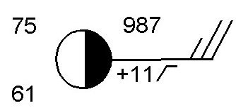
What is the dew point at this station?
a)
75 degrees
b)
61 degrees
c)
987 degrees
d)
11 degrees
87.
What is the temperature at this station
a)
75 degrees
b)
61 degrees
c)
987 degrees
d)
11 degrees
88.
What is the wind direction at this station?
a)
Wind is blowing from the north
b)
Wind is blowing to the East
c)
Wind is blowing from the East
d)
Wind is blowing to the North
89.

What type of cloud cover is present?

a)

Clear skies

b)

Full cloud coverage

c)

Partly cloudy

90.
After a cold front passes through, what type of weather will there be?   
a)
Rainy or stormy, and cloudy
b)
Clear, dry, and sunny
91.
What type of weather is associated with areas of low pressure?
a)
Low pressure = humid, because there is room in the air for moisture to get in 
b)
Low pressure = dry, because there is not room in the air for moisture to get in
92.
What type of weather is associate with areas of high pressure?
a)
High pressure = dry, because there is not room in the air for moisture to get in
b)
High pressure = humid, because there is room in the air for moisture to get in 
93.
What direction is the cold front moving?
a)
Northwest
b)
Southeast
c)
Northeast
d)
Southwest
94.
This symbol represents
a)
a cold front
b)
an occluded front 
c)
a stationary front
d)
a warm front
95.
Our weather generally moves in this direction...
a)
West to East
b)
East to West
c)
North to South
d)
South to North
96.
a)
High Pressure
b)
Warm Front
c)
Cold Front
d)
Mountains
97.
a)
Warm Front
b)
High Air Pressure
c)
Cold Front
d)
High Temperatures
98.

According to this map, a COLD FRONT is heading to NYS! What does this mean for the weather forecast?

a)

temperatures drop quickly and then steadily keep dropping

b)

temperatures rise quickly and the sun comes out

c)

temperatures drop quickly and then rise quickly after

99.

A front is

a)

where warm air is cooling at earth's surface

b)

a boundary where hot and cold air are separating

c)

a boundary where two different air masses meet

d)

where cold air is rising and forming rain clouds

100.

What type of front is the starred city experiencing?

a)

cold front

b)

warm front

101.

Which location would have warmer, more humid weather?

a)

A

b)

B

102.
Choose the best forecast for Los Angeles on Saturday.
a)
cooler temperatures
b)
warmer temperatures 
c)
low pressure
d)
snow
103.

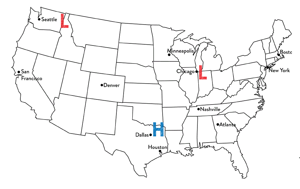
Tim said that Chicago is most likely to experience rainy weather. Jennifer thinks that Dallas is most likely to experience rainy weather.

Which student is correct?

a)

Tim because Chicago is the closest to a low pressure system and they produce precipitation.

b)

Jennifer because high pressure systems produce precipitation

c)

Both students are correct because all systems produce precipitation

d)

Neither of the students are correct because the cities are not close enough to the system.