
 Worksheets
7th GRADE UNIT 1 ASSESSMENT REVIEW
Total questions: 100
Worksheet time: 2hrs 48mins
The movement of the tectonic plates is caused by
the rotation of the Earth.
convection currents in the Asthenosphere
the gravity of the iron-nickel core.
the Moho discontinuity.
In some areas of the world, like California and Japan, earthquakes are a common occurrence. How can this best be explained?
The strong ocean currents are undermining both areas causing earthquakes.
Both areas are located near the edge of the Pacific Ocean, the unstable sand causes earthquakes.
Both areas are subjected to strong ocean wind and waves that causes earthquakes.
Both areas are on the boundary of active plates, the motion of the plates causes earthquakes.
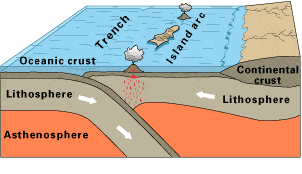
Observe this diagram of a plate boundary. One statement BEST describes what is happening. It is that
the oceanic crust is melting.
the denser ceanic crust is subducting under the less dense oceanic crust
volcanic islands are forming.
the tectonic plates are moving away from each other.
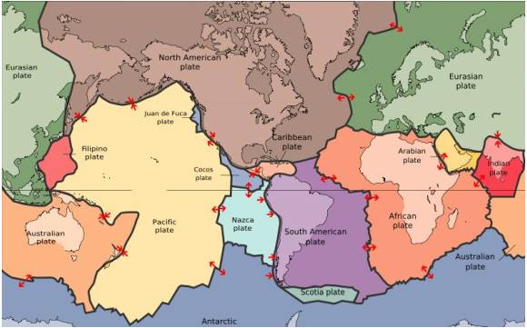
The map in the picture shows tectonic plate boundaries. This map would be useful in predicting the location of future
droughts
hurricanes
earthquakes
tornadoes
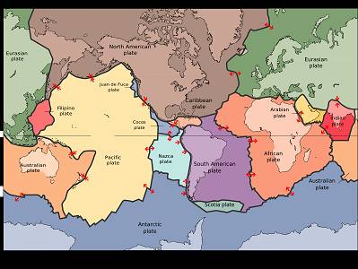
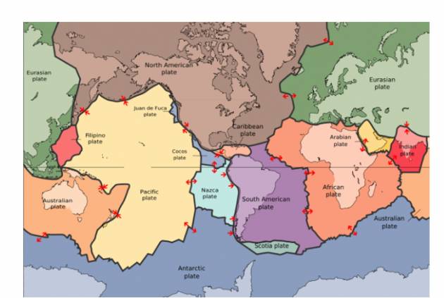
Where are earthquakes MOST LIKELY to occur?
close to the equator
close to the center of tectonic plates
at divergent or convergent plate boundaries
at transform plate boundaries
The 2004 Indian Ocean tsunami was caused by a shift in two plates that pushed one section of the sea floor under another section of the sea floor by 5 meters. What type of boundary is this?
divergent
convergent
transform
metamorphic
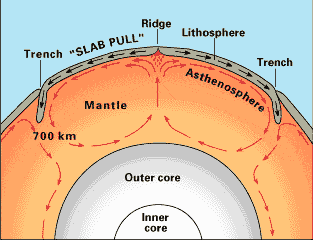
What is the source of energy that drives plate movement?
the subducton of the sea floor
the different densities of the oceanic and crustal plates
convection currents in the asthenosphere
the friction force between the plates that move past each other
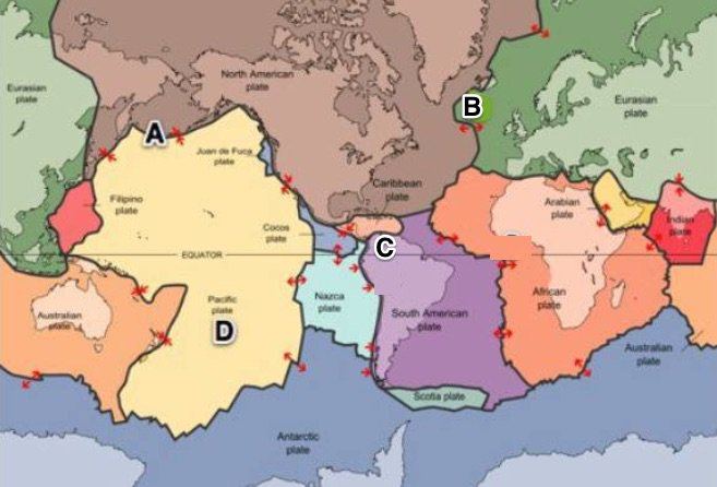
Where would sea floor spreading most likely occur?
At convergent boundaries (oceanic vs. oceanic)
At convergent boundaries (oceanic vs. continental)
At divergent plate boundaries (oceanic vs. oceanic)
At transform plate boundaries
The idea that continents were once part of a single landmass that broke apart and
moved
Continental Drift
Tectonic Plates
Transform
The land mass where all of the continents were once together in one large continent is called ________________.
Laurasia.
Pangaea.
Eurasia.
Gondwana.
The fact that similar fossils are found on both sides of the ocean is evidence of
magnetic reversal.
global positioning.
continental drift.
oceanic drift.
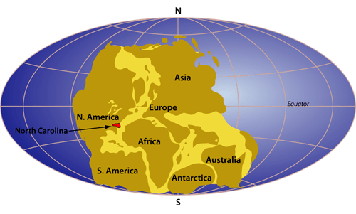
The three types of plate boundaries are
Convergent, divergent, change
Divergent, allegiant, insurgent
Convergent, divergent, transform
Push, pull, slide
Earth's plates meet at ____________.
plate tectonics
plate boundaries
continental drift
oceans
Plates slide past each other at _________________ boundaries.
divergent
convergent
transform
universal

What evidence of an ancient organism was used to support the theory that the continents used to be joined?
Same rocks were found on different continents
Glacial grooves were found on different continents
Fossilized evidence of the same organism found on different continents
Africa and South America look like puzzle pieces that fit together


Originally the Continental drift theory was not well received by other scientist. Why?
There was a competing theory at the time that was more believable.
There was no data showing the continents ever moved.
The scientists did not know the force responsible for moving the continents.
The scientist presenting the data was unreliable.

What volcano structure is number 1?
Ash cloud
Main vent
Secondary vent
Magma chamber
What volcano structure is number 2?
Ash cloud
Main vent
Secondary vent
Magma chamber
What volcano structure is number 3?
Ash cloud
Crater
Secondary vent
Magma chamber
What volcano structure is number 4?
Ash cloud
Crater
Secondary vent
Main vent
What volcano structure is number 5?
magma chamber
Crater
Secondary vent
Main vent


Which is a NEGATIVE consequence of volcanic activity?
Tourism
Ash accumulated in roofs
Mining activity
Geothermal energy


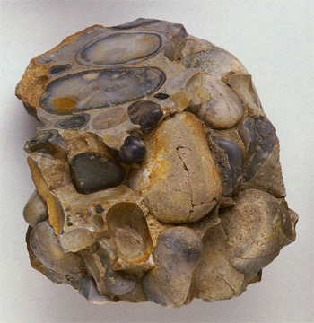
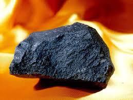

Which rocks are made by heat and pressure?
IGNEOUS
SEDIMENTARY
METAMORPHIC

What type of rock is made of tiny fragments of rocks?
SEDIMENTARY
IGNEOUS
METAMORPHIC
How many main kinds of rocks are on earth?
one
two
three
too many to count
I am the main type of rock that is created from hot lava that cools. What type of rock am I?
metamorphic
sedimentary
igneous
I am the main type of rock that is created from layers of sediment. What type of rock am I?
metamorphic
sedimentary
igneous
What must happen to a metamorphic rock before it becomes a sedimentary rock?
It must be broken down into sediment
It must be melted into magma
Its minerals must dissolve in water
It must be exposed to high temperature and pressure

Compaction and cementation are two common processes associated with:
Extrusive igneous rocks
Intrusive igneous rocks
Sedimentary rocks
Metamorphic rocks

This is the continuous process of rock changing from one type to another.
Igneous rocks
Sedimentary rocks
Metamorphic rocks
Rock Cycle
Which of the following lists the steps an igneous rock undergoes in order to become a sedimentary rock, in the correct order?
Deposition, erosion, melting, cooling
Erosion, weathering, eruption, cooling
Dissolving, deposition, cooling, fracture
Weathering, erosion, deposition, cementation

According to the diagram, what process is shown by letter A?
extrusion
erosion
crystallization
intrusion
According to the diagram, what process is shown by letter B?
compaction & cementation
weather & erosion
heat & pressure
melting
What is climate?
the condition of the atmosphere at any given time and place
cloud cover and temperature
precipitation and humidity at a given time and place
weather conditions in an area over a long period of time
Climate is affected by many factors including:
latitude, elevation, and proximity to bodies of water
tides and currents
wind
snow and sleet
At which latitude would you expect to find the warmest air temperatures?
23.5° S
0°
66.5°N
66.5°S
At which latitude would you expect to find the coldest air temperatures?
66.5°N
0°
23.5° S
23.5°N
These areas is located between 66.5°N and the North Pole and 66.5°S and the South Pole. It has low temperatures and very little precipitation.
Polar Climate Zones
Temperate Climate Zones
Tropical Climate Zones
The Arctic Climate Zones
What is elevation?
the depth of the ocean
the height of the atmosphere
the depth of a lake
the height above sea level
What climate zone is located near the equator where the sun is directly overhead all year?
polar
tropical
desert
temperate

Which zones are polar zones?
Zones A and B
Zones A and E
Zones E and D
Zones A, E, and C


The higher a place is above sea level, the _____ its climate.
cooler
warmer
The temperature of an inland city is usually hotter in the summer and cooler in the winter.
True
False
The temperature of an ocean current affects the ___________ of the land nearby.
climate
latitude
elevation
global winds
Areas closer to the _________ receive more direct sunlight.
North Pole
equator
temperate zone
______ temperature affects the movement of global winds.
Ground
Air
Mountain

What is the cause of rising surface temperatures of the Pacific Ocean, drier weather in the Northwestern United States, and flooding on the Pacific coast of South America?
El Niño
La Niña
the Gulf Stream
the jet stream

Which weather conditions are associated with El Niño?
decreased temperature, increased precipitation
increased temperature, decreased precipitation
increased temperature, increased precipitation
decreased temperature, decreased precipitation

Which lists some effects of El Niño?
warmer temperatures and less rain
cooler temperatures and less rain
cooler temperatures and more rai
warmer temperatures and more rain

Cooler Pacific ocean and less rain on the western coasts of South America and North America are impacts of which of the following weather phenomena?
El Niño
La Niña
the Gulf Stream
The Jet Stream

Which of the following best explains the relationship between an El Niño event and the tradewinds?
When the tradewinds increase in strength, El Niño occurs.
When the tradewinds decrease in strength, El Niño occurs.
Scientists do no understand what causes El Niño to occurs.
When the tradewinds blow west to east, El Niño occurs.

What causes La Niña?
cooling of water in the Atlantic Ocean off the coast of South America
cooling water in the Pacific Ocean off the coast of South America
cooling water off the Atlantic coast of the US
warm water in the Pacific Ocean off the coast of South America
A gradual increase in the average temperature of Earth's atmosphere:
Global Warming
Greenhouse Gas
El Niño
Climate
Gases in the atmosphere that trap heat; carbon dioxide (CO2) is a major one:
Greenhouse Gas
Global Warming
Sunspot
CFCs

Which zone is the tropical zone?
Zone B
Zone C
Zone D
Zone E
Possible human solutions for limiting global warming and climate change are...
being more energy-efficient
using renewable sources of energy
removing carbon from fossil fuel emissions
all of the above
Which of the following have been changed or altered due to climate change ?
droughts
flooding
melting of polar ice caps
all of the above

