
 Worksheets
Freshwater
Total questions: 92
Worksheet time: 2hrs 6mins
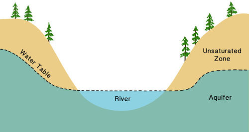
What is the best definition of a water table?
The level to which a river rises when it floods
The boundary between the land and the ocean
The top of the saturated zone in an aquifer
The bottom of the saturated zone in an aquifer
The top of the unsaturated zone in an aquifer
What is infiltration?
The process by which water sinks into the ground
The zone where there are still air spaces left between the particles.
The process by which water vapor turns into liquid water and forms fog or clouds.
The process by which water does not sink into the ground, but rather travels along the surface.

What process transforms the water vapor in the atmosphere to the liquid water in a cloud?
evaporation
infiltration
precipitation
transpiration
condensation

What process causes liquid water to evaporate from plant leaves and enter the atmosphere as water vapor?
evaporation
infiltration
precipitation
transpiration
condensation

Which soil would have the greatest permeability rate after a rainstorm?
sand (0.02 cm)
silt (0.002 cm)
clay (0.0002 cm)

These containers have the same volume of beads which are representing soil particles. What is the relative porosity and permeability of each?
The container on the left has the higher permeability and porosity
The container on the right has the higher permeability and porosity
The container on the left has the higher permeability, but they both have the same porosity
The container on the right has the higher permeability, but they both have the same porosity
Which surface would have the most runoff from it after a rainstorm?


Which surface would be impermeable?
Which of the following IS NOT true about groundwater?
Groundwater is the largest freshwater source on Earth.
Groundwater is freshwater beneath Earth’s surface.
Groundwater is the largest liquid freshwater source for humans.
Groundwater can maintain streamflow during times of drought.
Groundwater is thus a form of _________that _______________ streams during periods when rain does not fall.
storage, sustains
precipitation, dehydrates
saltwater, dries up
mineral, lithifies
Which of the following implies the same thing as the word "aquifer"?
zone of saturation
zone of aeration
zone of soil moisture
zone of twilight
The zone of soil moisture is considered to be groundwater.
True
False
Which of the following are wells used for? CHOOSE ALL THAT APPLY!
Wells are used to determine the height of the water table.
Wells are used to obtain water for crop irrigation.
Wells are used to obtain water for human consumption.
Wells are used to create barriers between aquifers, called aquatards.
What does the quantity of groundwater that can be stored depend upon?
It depends upon the porosity of the underground rock.
It depends upon the pH of the groundwater.
It depends upon the underground depth of the storage system.
It depends upon the temperature of the underground rock.
A place where the water table intersects the ground surface and where a natural flow of groundwater results is called:
a spring.
a geyser.
an aquatard.
a fissure.

According to the Karst map, in which of the following states would sinkholes be extremely rare?
North Dakota
Texas
Florida
Missouri
Identify which of the following are required to make a major cavern system. CHOOSE ALL THAT ARE NECESSARY.
Groundwater is often mildly acidic as it contains a weak solution of carbonic acid.
The acidic nature of groundwater will dissolve the calcite in limestone.
Caverns are formed by dissolving rock beneath the Earth’s surface.
Plate subduction can create caverns as one plate dives under another.
Geologically, groundwater is important as an agent of:
erosion
deposition
lithification
subduction
Which of the following is a hydrological problem currently facing the High Plains of the United States?
over-pumping of the Ogallala aquifer
compaction of the San Joaquin valley
mass amounts of human contamination seeping into the aquifer
flooding of Lake Mead
Which of the following depicts an artesian well?


In the diagram, the area labeled A is called the __________.
zone of infiltration
recharge zone
zone of saturation
zone of permeability
Much of the water that falls on the ground as precipitation __________.
enters the ground through the process of infiltration
evaporates back into the atmosphere
becomes runoff and finds its way back to the ocean
forms small pools

Water is able to flow more easily through the aquifer because its material has a ___________.
low permeability
low porosity
high porosity
high permeability


What do we call the highlands that separate watersheds?
Drainage basins
Estuaries
Divides
Meanders
How does a stream's discharge relate to a its carrying capacity?
There is no relationship
There is an inverse relationship
As discharge increases, carrying capacity decreases.
As discharge increases, the carrying capacity increases.
What is the lowest base level to which a stream can erode?
Sea level
Apogee
Zenith
Aquiclude
What is a fan-shaped deposit of sediments left when a stream’s slope suddenly becomes flat?
delta
alluvial fan
flood plain
isthmus
Why are wetlands important?
Improve water quality
provide habitats for wildlife
provide protection from storm damage
all of the above
none of the above
What do we call the process by which precipitation falls and becomes groundwater?
evaporation
condensation
discharge
infiltration
What factors affect a material’s porosity?
Grain size and shape
presence of cement
how well sorted the sediment is
all of the above
none of the above
What do we call explosive hot springs that erupt at regular intervals?
mud flats
geysers
hot fountains
aquifers
What causes a cone of depression around a well?
excessive recharge of the aquifer
abandonment of the well
overpumping/overuse of the well
excessive discharge at a stream

The part of the water cycle that includes rain, snow, and hail
Condensation
Evaporation
Precipitation
Transpiration

The part of the water cycle that involves plants releasing water to the atmosphere.
Condensation
Evaporation
Precipitation
Transpiration

The part of the water cycle that involves release of latent heat to the atmosphere.
condensation
evaporation
precipitation
transpiration

Water that runs across the surface after a rain is called
infiltration
evaporation
runoff
groundwater
Open space in a soil layer is called its
Permeability
Porosity
Aeration ability
Infiltration is best in places with
slopes with dense vegetation
slopes with little vegetation
flat areas with little vegetation
flat areas with grass
Which of the following is NOT a tributary of the Missouri River?
The Jefferson River
The Madison River
The Yellowstone River
The Mississippi River

What do you call an area of land drained by a river or stream?
the divide
the headwaters
the mouth
the watershed

Which of the following rivers has the largest watershed in America?
Columbia River
Mississippi River`
Colorado River
Missouri River

Which term is used to describe the smallest type of stream load?
dissolved load
suspended load
bed load
mother lode

Discharge is a measure of a stream's
area over time
speed over time
velocity over time
volume over time
What three things are needed to calculate a stream's discharge
length, width, and depth
width, depth, and volume
length, width, and volume
width, depth, and velocity
Natural levees can be found
along the edge of the banks of a river
in the middle of a flood plain
at the far edge of a flood plain
near the shore of a river

The amount of dissolved materials in a stream is expressed in
parts per hundred
parts per thousand
parts per million
parts per billion

The largest river in the world by discharge is
The Amazon
The Congo
The Mississippi
The Nile
Which of the following soil types has the worst porosity
sand
clay
silt
sandy loam

Which of the following types of stream load moves by saltation?
bedload
dissolved load
suspended load
surface load
What is a floodplain?
The area near a river that floods when water levels get to be too high.
The area near a river that looks boring or dull.
The process of water levels going over a river or stream bank.
Water gathering on the surface of the Earth because it doesn't seep into the ground.
The gradual movement or removal of sediment from a location by water is called...
erosion
runoff
slope
tributary
With a steeper slope, we would expect to see...
less erosion
more erosion
the same amount of erosion
no erosion at all
Which of these are traits of a stream’s floodplain? Select all that apply
It is nutrient poor
Is broader and deeper than its channel
Is where the stream deposits much of its sediment load
its elevation is usually higher than the river bed
What is weathering?
The movement of sediment
The breaking of sediment
The dropping of sediment
Small pieces of rock that have been weathered from a larger rock are known as...
sand
sediment
soil
Which of these is an example of erosion?
Light shinning onto a mountain
Rain breaking down rock
Wind blowing away sediment
All of the above
How do plants in the soil affect how fast erosion happens?
It doesn't affect erosion.
It slows down erosion.
It speeds up erosion.
Water, wind, and ice are examples of ________?
physical weathering
chemical weathering
biological weathering
movement weathering
What determines the size of sediment a river can carry?
river width
river speed
number of meanders
height of the levee
How is a flood plain created?
A stream cuts a new channel during a flood.A stream cuts a new channel during a flood.
A river overflows its banks and deposits sediment.
As it enters the ocean, a river slows down and drops its sediment.
A stream leaves a steep mountain valley, enters a flatter plain, and drops its sediment.

???
Tributary
Delta
Source
Streams
Rivers always flow __________
in a straight line
down hill
south
east to west
What is the process of sediments being placed in a new locations?
Deposition
Erosion
Weathering
Compaction
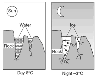
Which statement best explains why this process results in weathering?

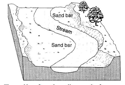
Madison creates the model shown of a stream bed. She wants to demonstrate how natural processes can change the surface of Earth through deposition and erosion. She pours water on her model and makes observations. In which situation will more deposition than erosion occur in Madison's stream bed model?
More deposition will occur if the slope of the stream increases.
More deposition will occur if sediment in the stream decreases.
More deposition will occur if sediment in the stream increases.
More deposition will occur if the speed of the stream water decreases.
How does erosion compare to physical weathering?
Both break down materials.
Erosion breaks down materials, and weathering carries them from place to place.
Weathering breaks down materials, and erosion carries them from place to place.
Both move materials from place to place.

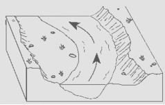
The white part in the river represents...
deposition due to slow water movement
deposition due to fast water movement
erosion due to slow water movement
erosion due to fast water movement
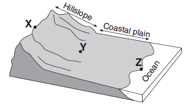
Compared to the stream velocity between point X and point Y, the stream velocity between point Y and point Z is most likely
greater, since the slope of the land decreases
greater, since the slope of the land increases
less, since the slope of the land decreases
less, since the slope of the land decreases

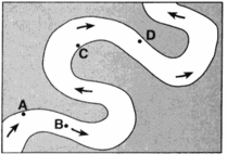
Erosion is most likely greatest at locations
A and B
B and C
C and D
D and A
Sediment is deposited in a river delta because the
velocity of the river decreases
force of gravity decreases
volume of the river increases
gradient of the river increases
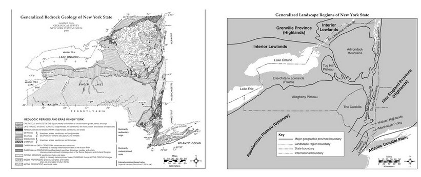
Which two cities are located in the Interior Lowlands?
Elmira and Binghamton
Riverhead and New York City
Massena and Old Forge
Buffalo and Watertown
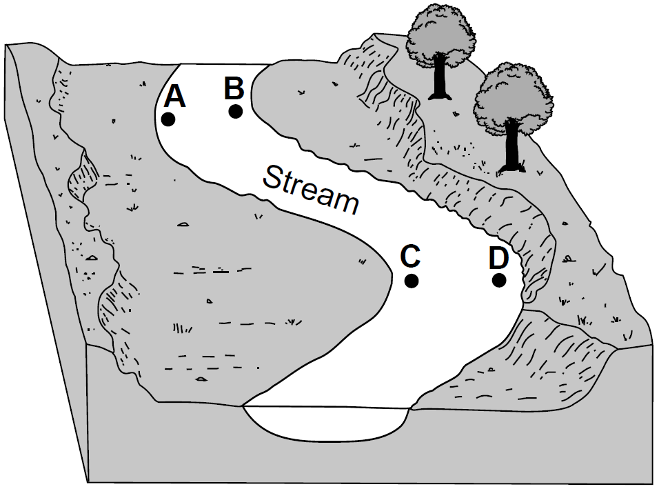
At which two locations would the stream most likely be the deepest?
A and B
B and C
C and D
D and A

