
NEW
Font size
 Worksheets
Quarter 3 review - weather, minerals and rocks, weathering
Total questions: 80
Worksheet time: 40mins
Which type of climate has the greatest amount of rock
weathering caused by frost action?
a wet climate in which temperatures remain
below freezing
a wet climate in which temperatures alternate
from below freezing to above freezing
a dry climate in which temperatures remain
below freezing
a dry climate in which temperatures alternate
from below freezing to above freezing
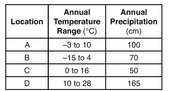
The table shows general climate conditions of
four different locations, A, B, C, and D.
In which location is chemical weathering probably
greatest, based on these climate conditions?
A
B
C
D
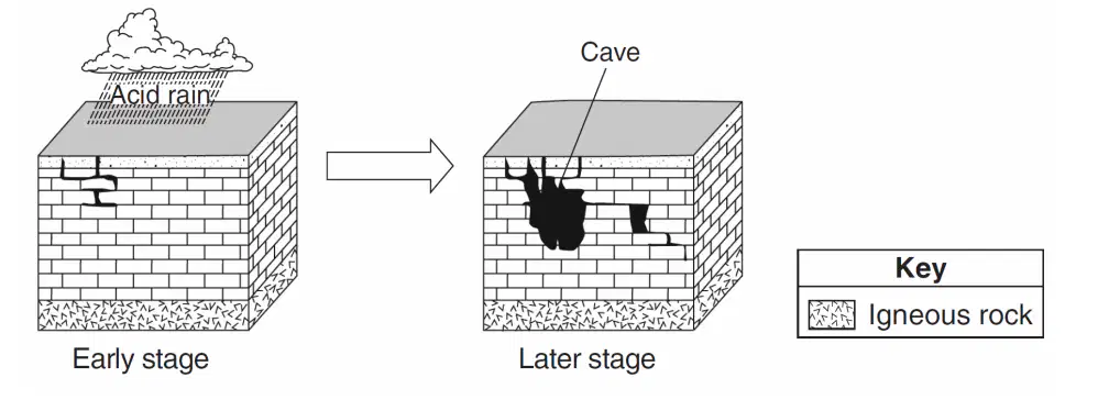
The two block diagrams below represent the formation of caves.
Which types of weathering and erosion are primarily responsible for the formation of caves?
chemical weathering and groundwater flow
chemical weathering and runoff
physical weathering and groundwater flow
physical weathering and runoff
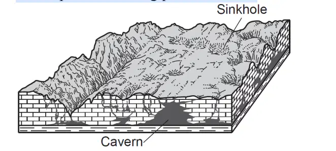
The block diagram below represents a landscape
where caverns and sinkholes have gradually
developed over a long period of time.
Why did these caverns and sinkholes form?
The bedrock chemically reacted with acidic
groundwater.
This type of bedrock contained large amounts of
oxygen and silicon.
Glacial deposits altered the shape of the bedrock.
Crustal uplift formed gaps in the bedrock.
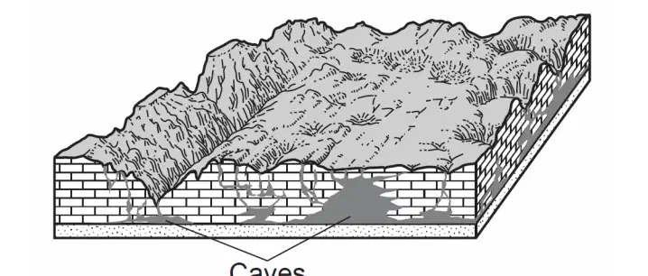
The block diagram below represents caves that
developed in a region over time.
Which type of weathering was primarily responsible
for the development of these caves?
physical weathering of sandstone
physical weathering of limestone
chemical weathering of sandstone
chemical weathering of limestone
Which rock weathers most rapidly when exposed to
acid rain?
quartzite
granite
basalt
limestone
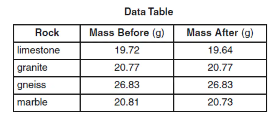
The weathering of four different rock samples with different masses was studied. Each rock sample was placed in a separate beaker containing 500 milliliters of a dilute acid for 10 minutes.
Bubbling was observed in some of the beakers. The data table beloW shows the mass of each sample, in grams, before placement in the acid and after removal from the acid.
Which table correctly shows the classification of the rock samples based on the amount of weathering during this experiment?


The weathering of four different rock samples with different masses was studied. Each rock sample was placed in a separate beaker containing 500 milliliters of a dilute acid for 10 minutes.
Bubbling was observed in some of the beakers. The data table beloW shows the mass of each sample, in grams, before placement in the acid and after removal from the acid.
Which Earth process is being modeled in this experiment?
physical weathering in the hydrosphere
physical weathering in the mesosphere
chemical weathering in the hydrosphere
chemical weathering in the mesosphere
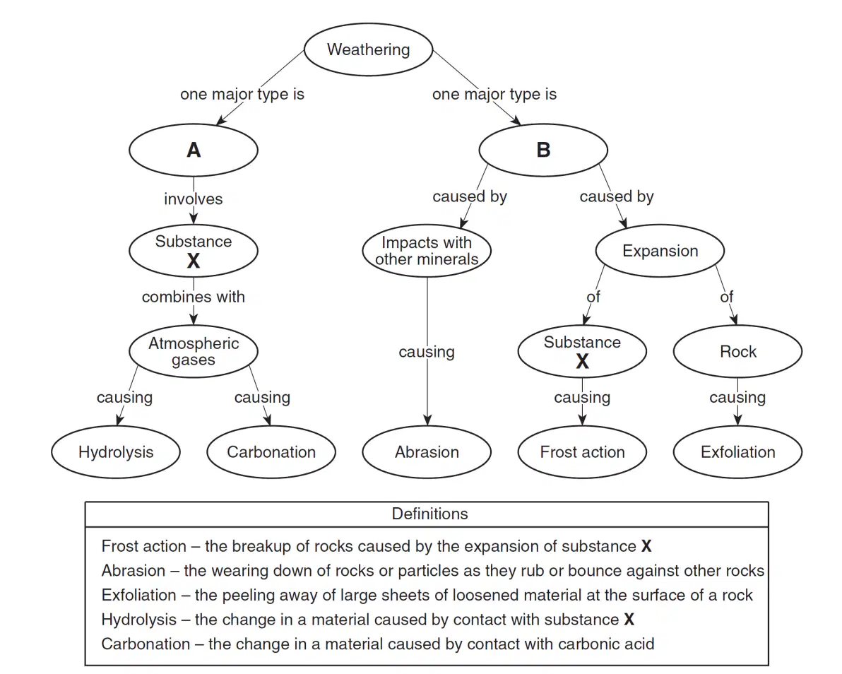
Base your answer on the flowchart below, which shows a general overview of the processes and substances involved in the weathering of rocks at Earth's surface. Letter X represents an important substance involved in both major types of weathering, labeled A and B on the flowchart.
Some weathering processes are defined below the flowchart.Which weathering process is most common in a hot, dry environment?
abrasion
carbonation
frost action
hydrolysis
Base your answer on the flowchart below, which shows a general overview of the processes and substances involved in the weathering of rocks at Earth's surface. Letter X represents an important substance involved in both major types of weathering, labeled A and B on the flowchart.
Some weathering processes are defined below the flowchart. Which substance is represented by X on both sides of the flowchart?
potassium feldspar
air
hydrochloric acid
water
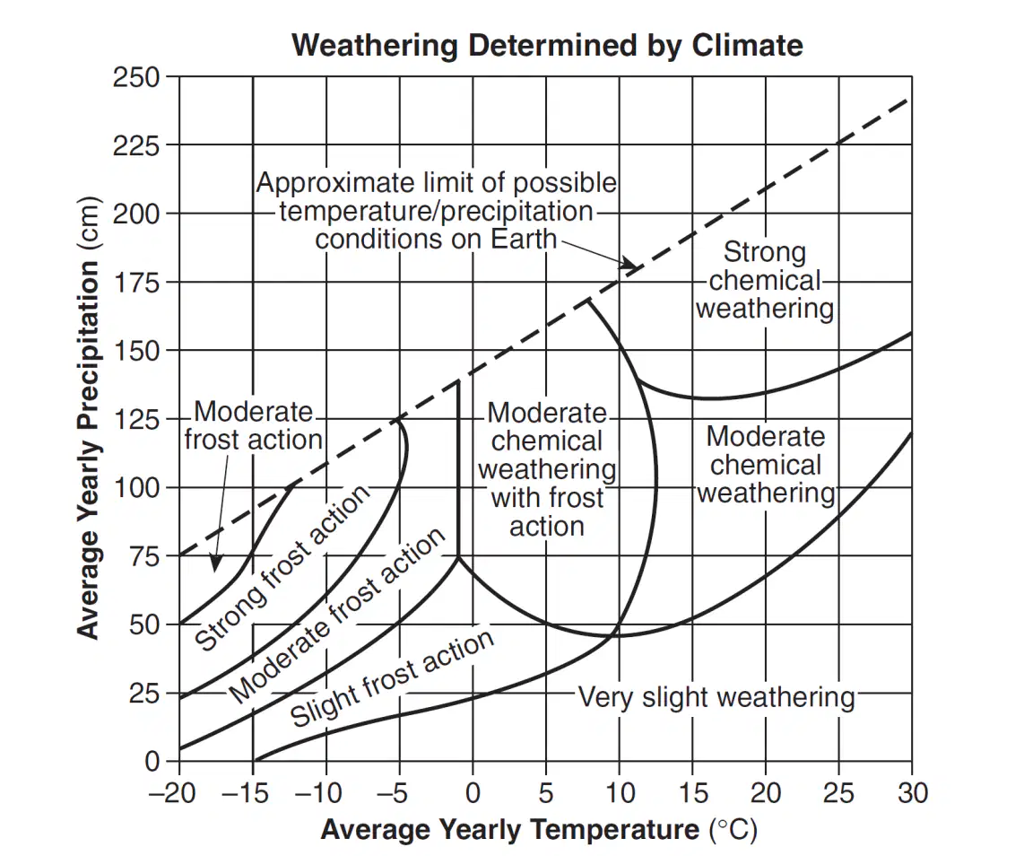
Base your answer to the following question on the graph below, which shows the effect that average yearly precipitation and temperature have on the type of weathering that will occur in a particular region. The amount of chemical weathering will increase if
air temperature decreases and precipitation decreases
air temperature decreases and precipitation increases
air temperature increases and precipitation decreases
air temperature increases and precipitation increases
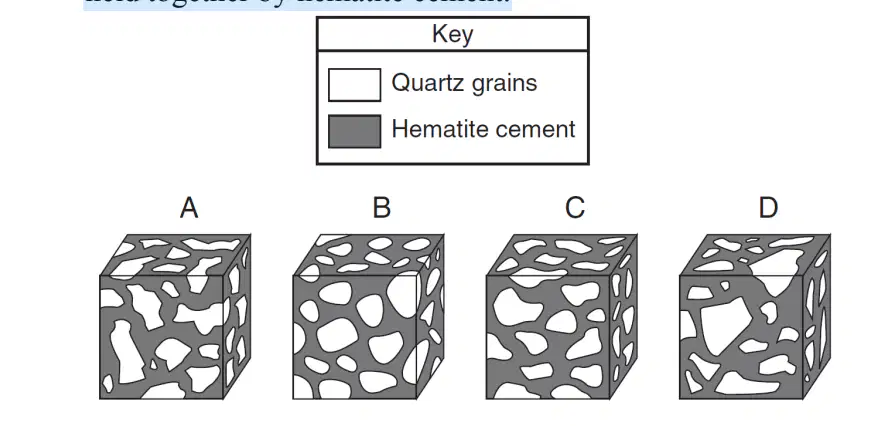
The diagram below shows four magnified block-shaped sandstone samples labeled A, B, C, and D. Each sandstone sample contains quartz grains of different shapes and sizes. The quartz grains are held together by hematite cement.
In which sample did the quartz grains undergo the most abrasion during erosional transport?
A
B
C
D
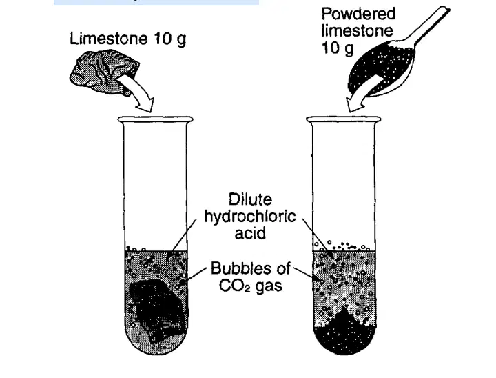
The demonstration shown in the diagram below
indicates that powdered limestone reacts faster than a single large piece of limestone of equal mass when
both are placed in acid. The most likely reason powdered limestone reacts faster is that it has
less total volume
more chemical bonds
more total surface area
lower density
What occurs when a rock is crushed into a pile of fragments?
The total surface area decreases and chemical
composition changes.
The total surface area decreases and chemical
composition remains the same.
The total surface area increases and chemical
composition changes.
The total surface area increases and
chemical composition remains the same.
What are two major factors that control the
development of soil in a given location?
vegetative cover and slope
tectonic activity and elevation
erosion and transpiration
bedrock composition and climate
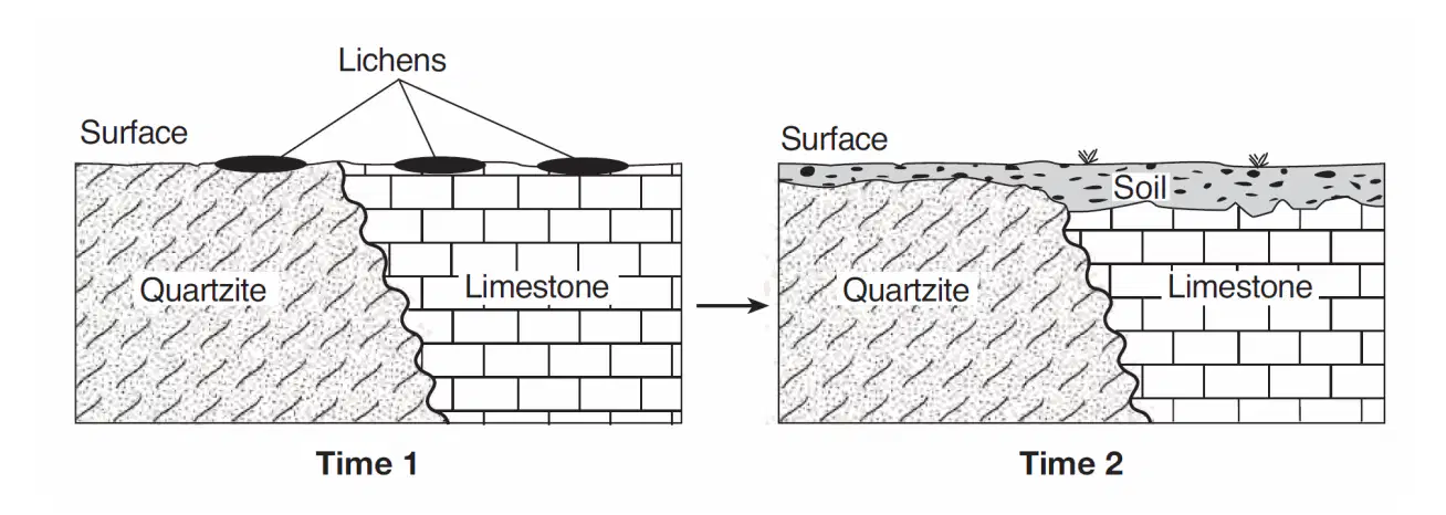
Lichens are usually the first organisms that appear in barren, rocky areas. They use rootlike structures to split bedrock into small fragments. Lichens also secrete acidic solutions that help break down rock. The cross sections below represent an area when lichens first appeared (time 1) and that same area hundreds of years later, after it was changed by lichens and exposed to air and water (time 2). The soil shown in time 2 was formed mainly by
compaction and cementing
weathering and biological activity
faulting and tilting of rock strata
mass movement and deposition of particles
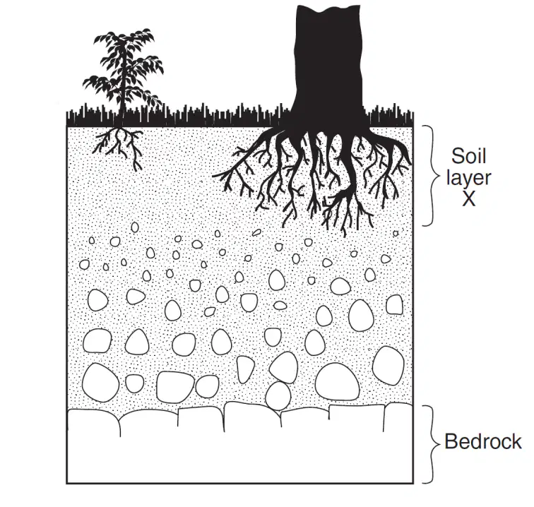
The cross section below shows soil layer X, which
was formed from underlying bedrock.
Which change would most likely cause soil layer to
increase in thickness?
a decrease in slope
a decrease in rainfall
an increase in biologic activity
an increase in air pressure
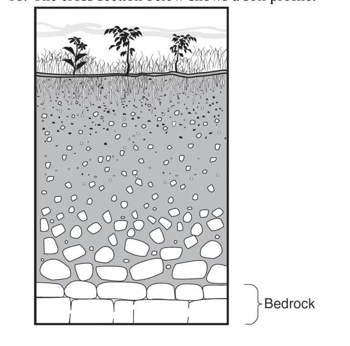
The cross section below shows a soil profile.
This soil was formed primarily by
erosion by glaciers
erosion by running water
capillarity and human activity
weathering and biological activity
Which two minerals are commercial sources of iron?
galena and graphite
muscovite mica and biotite mica
garnet and flourite
hematite and magnetite
Which material is made mostly of the mineral
quartz?
sulfuric acid
plaster of paris
pencil lead
window glass
The three statements below are observations of the
same rock sample:
• The rock has intergrown crystals from 2 to 3 millimeters in diameter.
• The minerals in the rock are gray feldspar, green olivine, green pyroxene, and black amphibole.
• There are no visible gas pockets in the rock.
This rock sample is most likely
sandstone
gabbro
granite
phyllite
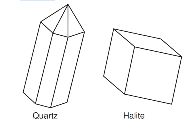
The diagrams below show the crystal shapes of two minerals.
Quartz and halite have different crystal shapes
primarily because
light reflects from crystal surfaces
energy is released during crystallization
of impurities that produce surface variations
of the internal arrangement of the atoms
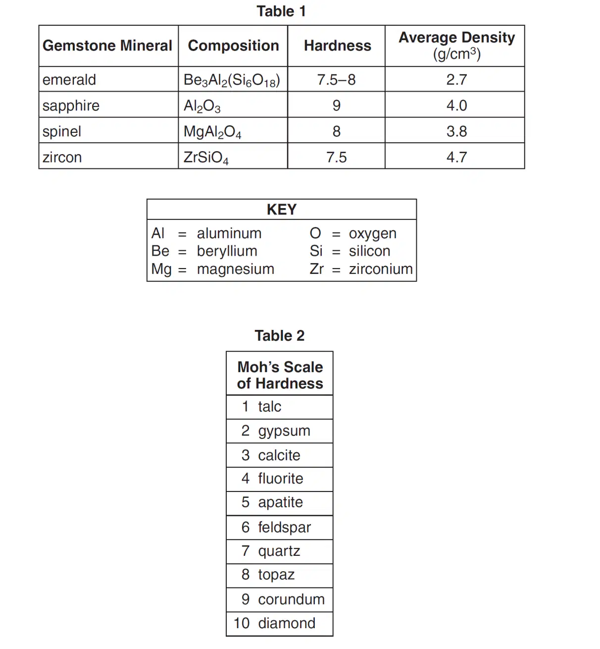
Which gemstone minerals contain the two most abundant elements by mass in Earth's crust?
emerald and spinel
emerald and zircon
sapphire and spinel
sapphire and zircon
The hardness and density of each gemstone is based primarily on the gemstone's
internal arrangement of atoms
oxygen content
geologic time of formation
natural abundance
A mixture of rounded pebbles and sand was
deposited in a river. Over time, these sediments were
compacted and cemented together to form the
sedimentary rock
conglomerate
sandstone
breccia
shale
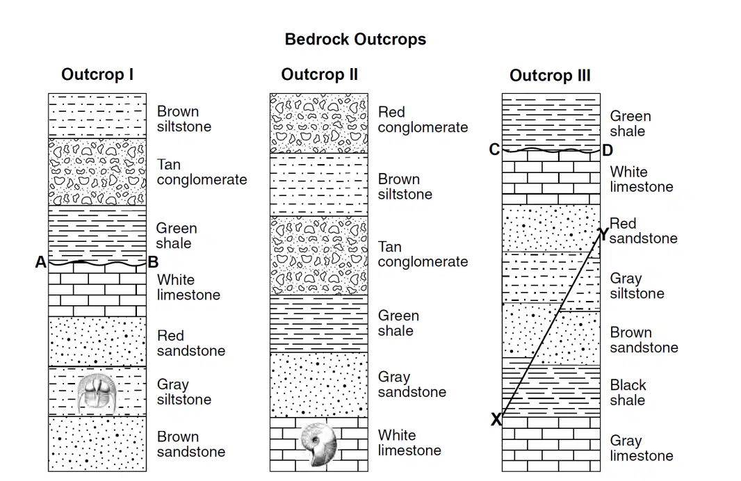
The outcrops, labeled I, II, and III, are located within 15 kilometers of
each other. Lines AB and CD represent unconformities. Line XY represents a fault. No overturning of the layers has occurred.
Which processes produced the brown siltstone layer in outcrops I and II?
cooling and solidification of mafic lava at Earth's surface
cooling and solidification of felsic magma deep within Earth
compaction and cementation of rock fragments ranging in size from 0.006 to 0.2 centimeter in
diameter
compaction and cementation of rock fragments ranging in size from 0.0004 to 0.006
centimeter in diameter
Which rock is composed of a mineral that can be
used for the production of cement?
basalt
rock salt
limestone
rock gypsum
Which map symbol is used to represent rock that
formed as a result of the evaporation of seawater?


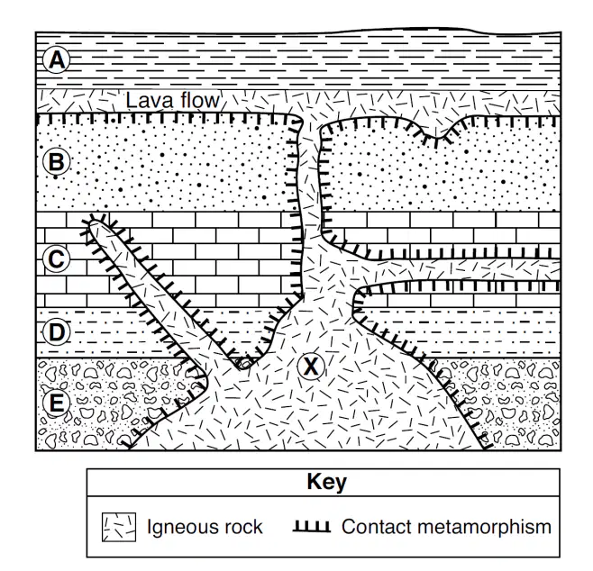
Base your answer to the following question on the cross section below and on your knowledge ofEarth science. The cross section represents rock units labeled A through E that have not been overturned. A lava flow is represented between rock units A and B. Letter X represents a location in the igneous rock. Which two minerals would most likely be found in the igneous rock if the rock is highly mafic?
quartz and potassium feldspar
quartz and pyroxene
olivine and potassium feldspar
olivine and pyroxene
Which igneous rock is formed from magma that cooled slowly and is composed of 5% amphibole, 8% biotite, 15% plagioclase feldspar, 37% quartz, and 35% potassium feldspar?
rhyolite
granite
diorite
scoria
Which igneous rock could physically weather to
beach sand that contains the minerals pyroxene,
plagioclase feldspar, and olivine?
dunite
granite
peridotite
gabbro
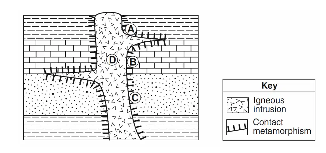
The cross section below represents a portion of Earth's crust. Letters A through D are locations within the rock units.
At which location is quartzite most likely found?
A
B
C
D

Which rock most probably formed in the contact metamorphic zone within rock unit 6?
marble
basalt
quartzite
hornfels
Which characteristic of the granite intrusion provides the most evidence that it solidified deep
underground?
very hard
coarse texture
light color
felsic composition
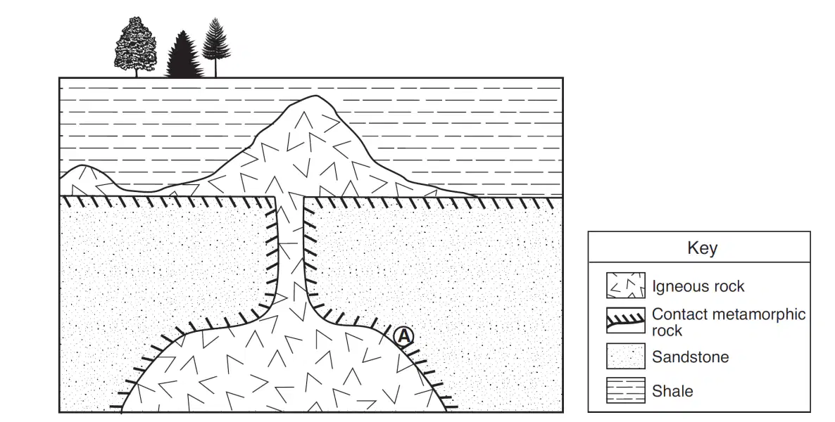
Base your answer to the following question on the geologic cross section below. Location A is within the metamorphic rock. The metamorphic rock at location A is most likely
marble
quartzite
phyllite
slate
Which two kinds of adjoining bedrock would most
likely have a zone of contact metamorphism
between them?
shale and conglomerate
shale and sandstone
limestone and sandstone
limestone and granite
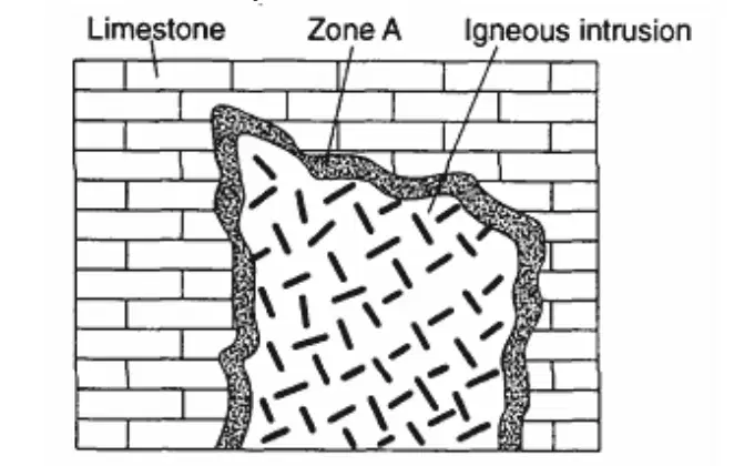
The geologic cross section below shows limestone
that was intruded. Part of the limestone (zone A) was
heated intensely but was not melted. Which type of rock most likely formed in zone A?
gneiss
gneiss
marble
obsidian
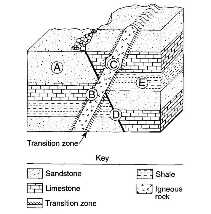
At which location is metamorphic rock most likely to
be found?
A
B
C
D

The diagrams represent electromagnetic waves being transmitted (T) by a Doppler radar weather instrument and waves being reflected (R) by rain showers. This instrument produces computer images that show the movement of rainstorms. Which weather instrument was used to measure the amount of rainfall from this storm?
barometer
anemometer
precipitation gauge
wind vane
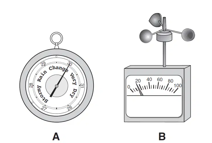
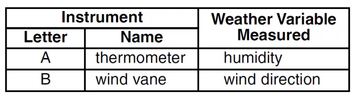
The diagram below shows weather instruments A and B.
Which table correctly indicates the name of the weather instrument and the weather variable that it measures?
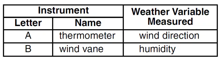
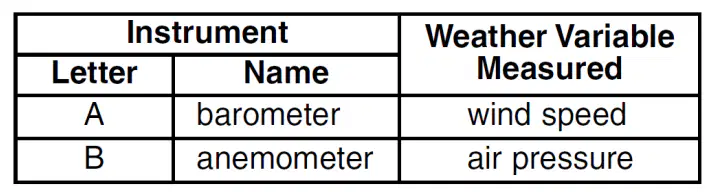
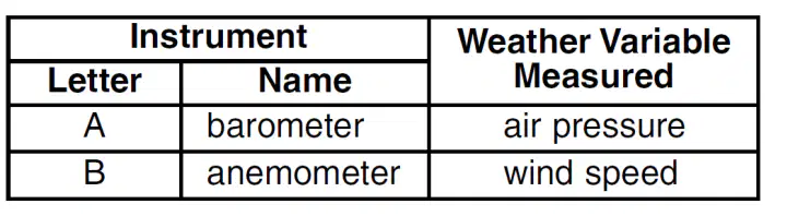
Which list correctly matches each instrument with
the weather variable it measures?
wind vane—wind speed
thermometer—temperatureprecipitation gauge—relative humidity
wind vane—wind direction
thermometer—dewpoint
psychrometer—air pressure
barometer—relative humidity
anemometer—cloud cover
precipitation gauge—probability of
precipitation
barometer—air pressure
anemometer—wind speed
psychrometer—relative humidity
Which weather change is most likely indicated by
rapidly falling air pressure?
Humidity is decreasing.
Temperature is decreasing.
Skies are clearing.
A storm is approaching.
Weather-station measurements indicate that the
dewpoint temperature and air temperature are
getting farther apart and that air pressure is rising.
Which type of weather is most likely arriving at the
station?
a snowstorm
a warm front
cool, dry air
maritime tropical air
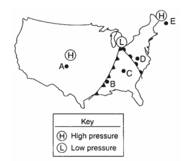
The map below shows high-pressure and
low-pressure weather systems in the United States. Which two lettered positions on the map are most likely receiving precipitation?
A and B
B and D
C and E
A and D
Monsoons develop as a result of
large changes between the temperatures of a
continent and neighboring oceans
a continent and neighboring oceans having
nearly the same temperatures
air rising over Earth's equatorial region
air sinking over Earth's polar regions
The presence of which atmospheric condition will
most likely result in clear skies in Binghamton, New
York?
high humidity
high-pressure center
increasing wind speed
dewpoint equal to air temperature
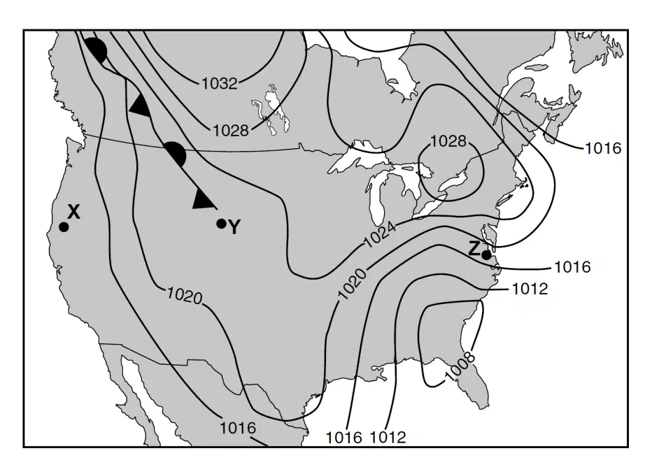
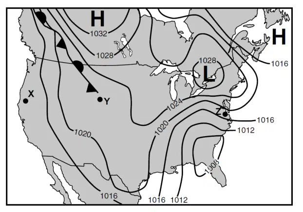
The map shows typical weather systems over North America. Letters X,Y, and Z represent locations on the map. The isobars on the map are measured in millibars (mb). Which map information indicates that the wind velocity is greater at location Z than at location X?
Location Z is closer to the ocean
The isobars are closer together at Z
The latitude of location X is greater
Location X is closer to the front
The map shows typical weather systems over North America. Letters X,Y, and Z represent locations on the map. The isobars on the map are measured in millibars (mb). Which type of front extends northwest from location Y?
warm front
cold front
occluded front
stationary front
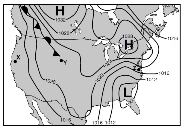
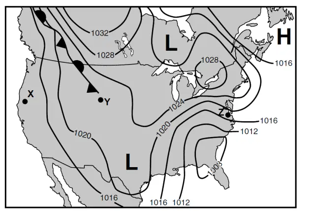
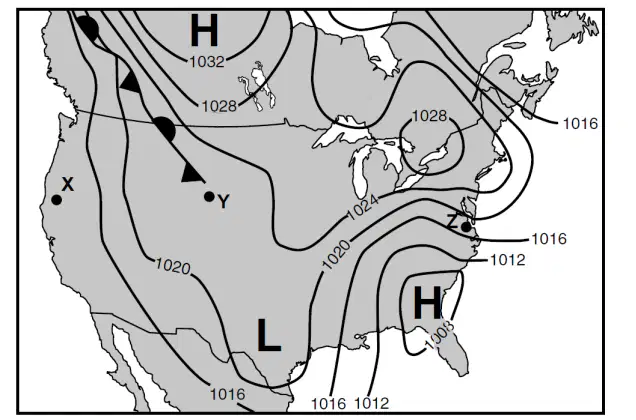
The map shows typical weather systems over North America. Letters X,Y, and Z represent locations on the map. The isobars on the map are measured in millibars (mb). Which map best shows the locations for the centers of high pressure (H) and low pressure (L)?
warm front
cold front
occluded front
stationary front
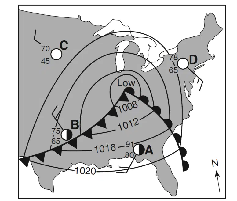
Which weather instrument was used to measure wind speed at station D?
barometer
thermometer
psychrometer
anemometer
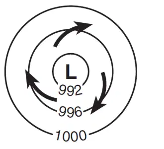
Surface winds within this low-pressure system most likely are flowing
toward the center in a clockwise pattern
toward the center in a counterclockwise pattern
away from the center in a clockwise pattern
away from the center in a counterclockwise pattern
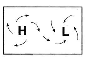
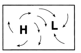
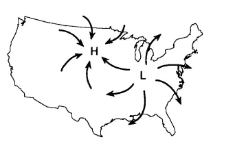
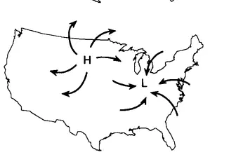
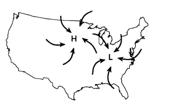
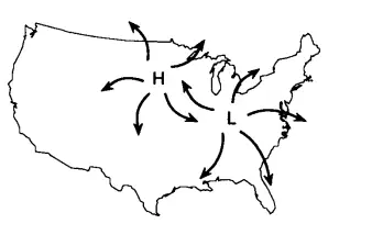
Which map best represents the surface wind pattern
around Northern Hemisphere high-pressure and
low-pressure centers?
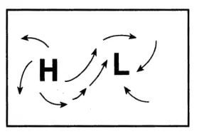
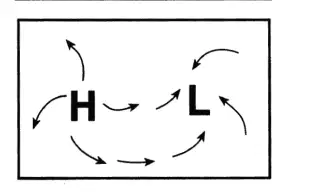
Which current has a cooling effect on the climate of
the west coast of South America?
Falkland Current
Peru Current
Benguela Current
Brazil Current
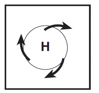
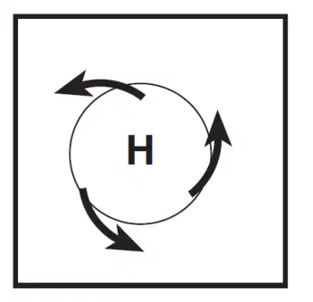
Which map best represents the surface wind pattern
around a Northern Hemisphere high-pressure center?
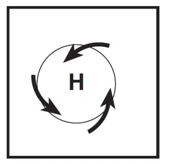
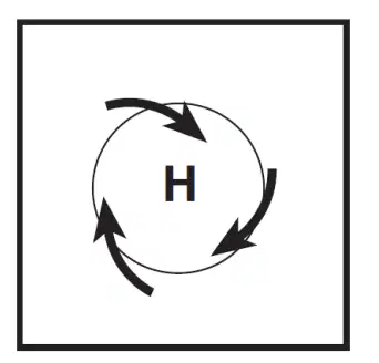
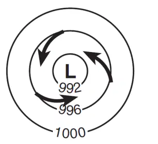
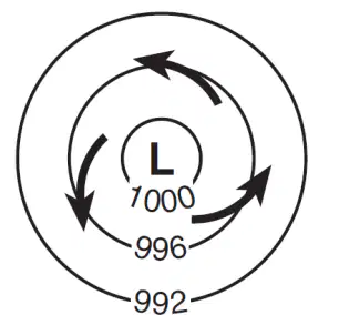
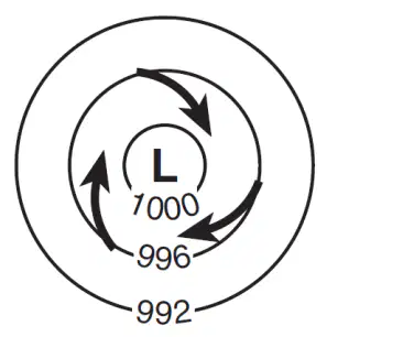
Which map view best represents the pattern of isobar
values, in millibars, and the pattern of wind flow,
shown by arrows, at Earth's surface surrounding a
Northern Hemisphere low-pressure center?
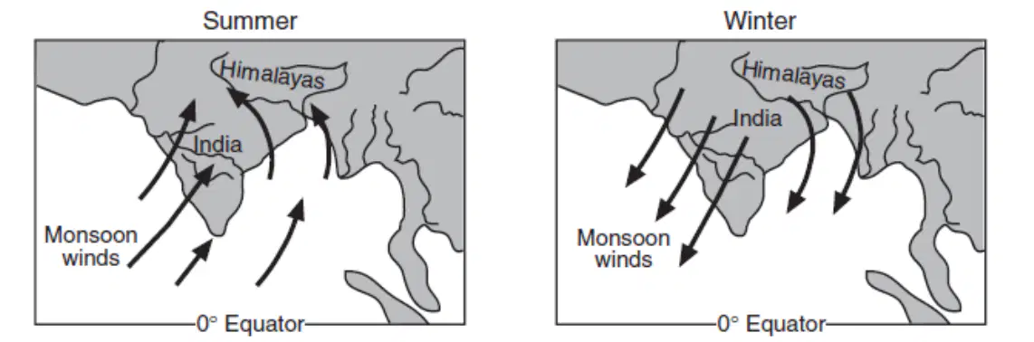
The arrows on the two maps below show how the monsoon winds over India change direction with the seasons. How do these winds affect India's weather in summer and winter?
Summer is cooler and less humid than winter.
Summer is warmer and more humid than winter.
Winter is warmer and less humid than summer.
Winter is cooler and more humid than summer.
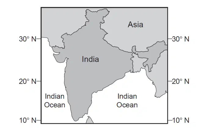
The map below shows the location of India and the
Indian Ocean.
Which statement best describes the monsoon winds
during the rainy season in India?
Warm, moist air flows from India to the Indian
Ocean.
Warm, moist air flows from the Indian
Ocean to India.
Cold, dry air flows from India to the Indian
Ocean.
Cold, dry air flows from the Indian Ocean to
India.
Which map correctly shows the wind directions of
the high-pressure and low-pressure systems?
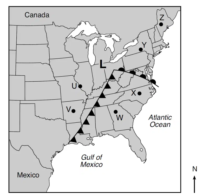
Base your answer to the following question on the map below and on your knowledge of Earth science. The map shows a low-pressure system over the eastern United States. Points U through Z represent locations on Earth's surface. Which two locations most likely have the warmest air temperatures?
Y and Z
U and V
V and W
W and X
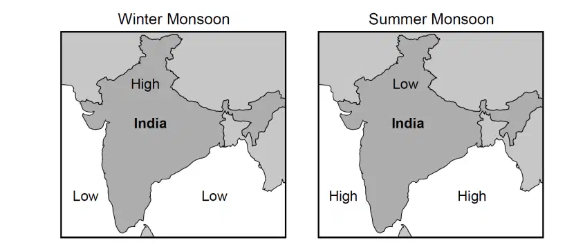
The maps show a portion of India and Southeast Asia, bordering on the Indian Ocean, during the winter and summer monsoon seasons. Large areas of high and low air pressure are shown during each season. The heavy monsoon rains affecting India and Southeast Asia occur during
winter, when winds blow from the land
winter, when winds blow toward the high pressure
summer, when winds blow from the ocean
summer, when winds blow toward the high pressure
The maps show a portion of India and Southeast Asia, bordering on the Indian Ocean, during the winter and summer monsoon seasons. Large areas of high and low air pressure are shown during each season. Which two-letter symbol represents the most likely air mass formed over portions of the Indian Ocean shown on the maps?
mP
mT
cP
cT
Which type of air mass would most likely form over
the Pacific Ocean north of Aleutian Trench?
mP
mT
cP
cT

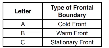
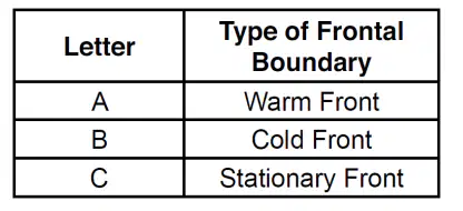
The three diagrams below represent three frontal boundaries with the surface locations of the fronts labeled A, B, and C. Arrows indicate direction of air movement. Which table correctly matches each letter with the type of frontal boundary it represents?
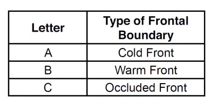
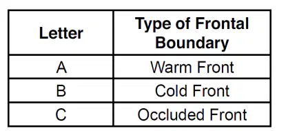
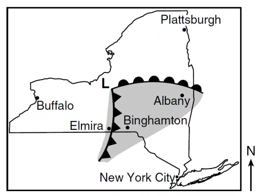
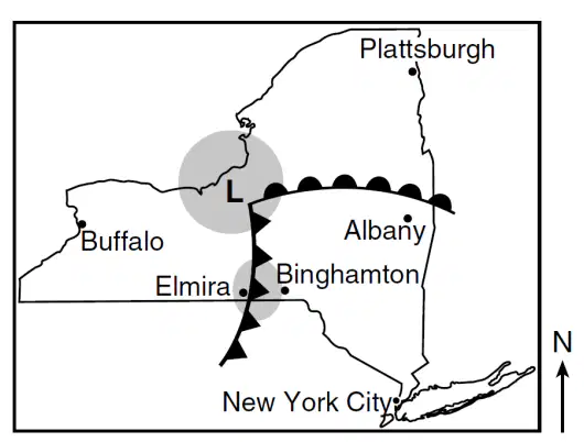
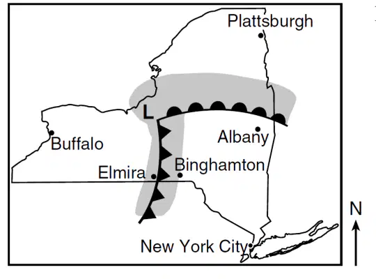
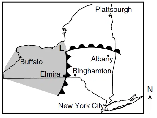
The weather map shows a low pressure system over New York State on a July day. The L represents the center of the low, and two fronts extend from this center. Locations of some cities are indicated.Which map shows the most probable areas of precipitation that would appear on a radar image taken at the time of these frontal positions?
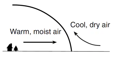
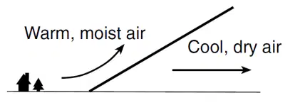
Which cross section best represents a cold front?
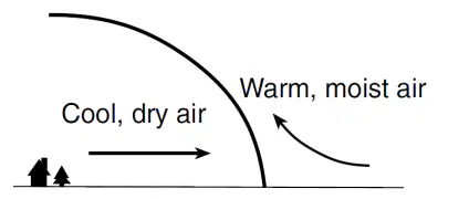
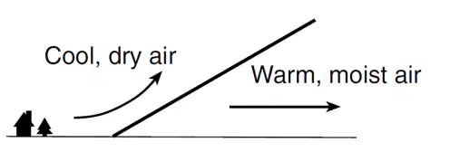
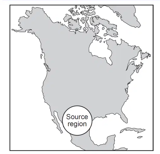
The map of North America below shows the source region of an air mass forming mostly over Mexico. This air mass originating over Mexico is classified as
continental polar
continental tropical
maritime polar
maritime tropical
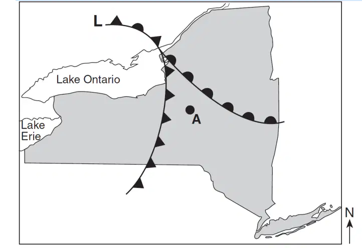
The weather map below shows a portion of a low-pressure system.
Which front will most likely pass over location A during the next two hours'?
warm
stationary
occluded
cold
What is the dewpoint when the dry-bulb temperature
is 8°C and the wet-bulb temperature is 2°C?
28°C
6°C
3°C
–9°C
Which geographic region is the most common
source region for the mT air masses that move into
New York State?
northern Canada
Gulf of Mexico
Arctic Ocean
southwestern United States
Which area is the most common source region for
cold, dry air masses that move over New York State?
North Atlantic Ocean
Gulf of Mexico
central Canada
central Mexico
Which air mass is associated with low relative
humidity and high air temperature?
maritime polar
maritime tropical
continental polar
continental tropical
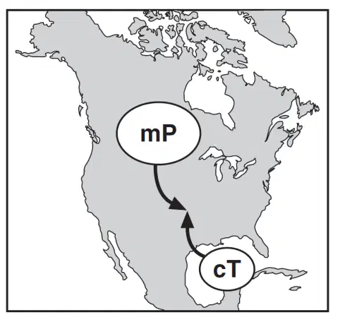
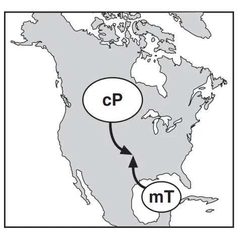
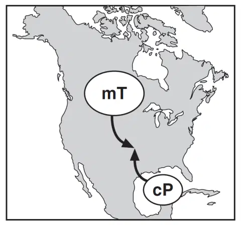
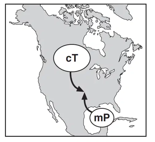
Which map shows the two correctly labeled air masses that frequently converge in the central plains to cause tornadoes?

The best explanation for this temperature difference is that location C
is in the polar NE wind belt
is farther from the equator
has less cloud cover
has more frequent tornadoes
Which combination of climate factors generally
results in the coldest temperatures?
low elevation and low latitude
low elevation and high latitude
high elevation and low latitude
high elevation and high latitude
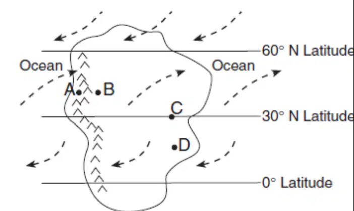
Base your answer to the following question on
the map below, which shows an imaginary continent on Earth. Arrows represent prevailing wind directions. Letters A through D represent locations on the continent. Locations A and B are at the same latitude and at the same elevation at the base of the mountains.The climate at location C is much drier than at location D. This difference is best explained by the
fact that location C is located
farther from any mountain range
closer to a large body of water
at a latitude that experiences longer average
annual daylight
at a latitude where air is sinking and surface
winds diverge
Mount Kilimanjaro is located in eastern Africa at 3°
S. Which climate factor best explains the presence of
permanent snow on its peak?
latitude
elevation
prevailing winds
ocean currents
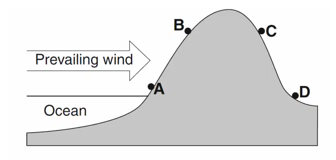
The cross section below represents four locations on
a mountain. The arrow indicates the prevailing wind
direction.
Which location has the warmest and most arid
climate?
A
B
C
D
Which ocean current warms the climate along a
continent's east coast?
California Current
Brazil Current
Falkland Current
Guinea Current
El Niño is a condition associated with a buildup of
unusually warm water along the western coast of
South America. Which changes in air temperature
and precipitation usually occur in that region during
El Niño?
lower air temperature and less precipitation
lower air temperature and more precipitation
higher air temperature and less precipitation
higher air temperature and more
precipitation
Which ocean current brings warm water to the
southeastern tip of Africa?
Brazil Current
Agulhas Current
Guinea Current
Benguela Current

