
 Worksheets
Chapter 5 Plate Tectonics
Total questions: 65
Worksheet time: 5hrs 25mins
Which scientist proposed the continental drift hypothesis in 1911?
Wegener
Tharp
Hess
Richter
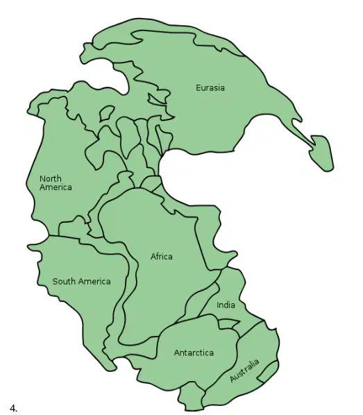
At a past point in Earth’s history, the continents were all connected as in the image above.
TRUE
FALSE
What does the theory of continental drift state?
The continents were once much farther apart and have since been moving together
There used to be more continents than there are today, but some are now underwater
Continents move by floating on water
The continents were all joined together and slowly drifted apart
SELECT ALL POSSIBLE ANSWERS:
Which of these statements supports continental drift?
Identical fossils found on different continents
Continents that fit together like puzzle pieces
Different ferns on different continents
Identical rocks found on different continents
Wegener’s continental drift theory provided evidence that explains how the continents drifted to their current locations.
TRUE
FALSE
Why did most scientists dismiss Alfred Wegener’s hypothesis of continental drift?
Wegener was interested in what Earth was like millions of years ago
Wegener used several different types of evidence to support his hypothesis
They thought the continents would not be deformed
Wegener could not identify a force that could move the continents
In 1915, Wegener published a book called The Origin of Continents and Oceans
TRUE
FALSE
Pangea is the name of the supercontinent which Wegener believed existed about 300 million years ago.
TRUE
FALSE
Magnetite in rocks of various ages point to different locations, which suggest that:
The poles moved significantly
There are multiple North poles
The continents have moved
Everything is stationary
Which of the following discoveries led to a revival of Wegener’s continental drift hypothesis?
Discovery of marsupials
Variation in the orientation of magnetite
Radioactive dating
Magnetite crystals points to the magnetic north pole are evidence for continental drift if:
The pole is moving across the landscape
The pole is flipping with the magnetic south pole
The pole is stationary but the continent is moving
The pole is stationary and the continent is stationary
How does the variation between the alignment of magnetite crystals and the current magnetic north pole serve as evidence to support the theory of continental drift?
It indicates that the continents have moved over time, as the rocks’ alignments do not match the current magnetic north pole
It indicates that Earth has had multiple magnetic north poles in its history
As the continents drifted apart, the rocks’ alignments gradually changed, ultimately aligning with the current magnetic north pole
It indicates the magnetic north pole has shifted significantly throughout history, causing the disparity in rock alignments on the same continent
Crystals that point in the direction of the magnetic north pole are made of
Peridotite
Hematite
Magnetite
Granite
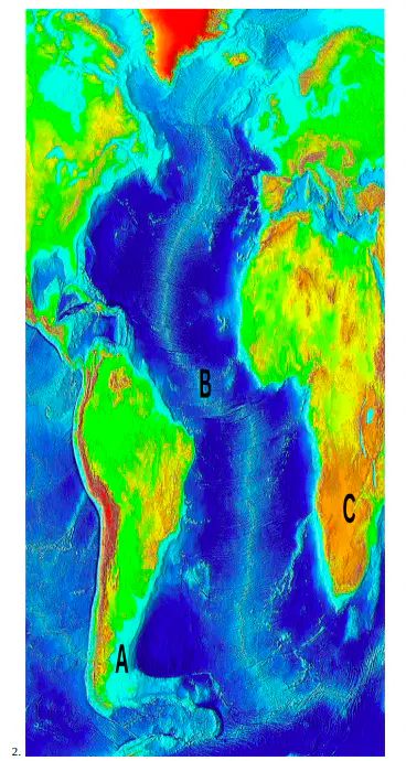
The image above shows a bathymetric map of the Atlantic Ocean. Which geologic feature is a mid-ocean ridge?
Off the east coast of South America
In the middle of the Atlantic Ocean
In southern Africa
_____________ were used to map the ocean floor using the speed of sound through water.
Map makers
Echo sounders
Ocean floor walkers
Submersibles
___________ lie(s) between the foot of a continental rise and a mid-oceanic ridge.
The continental slope
The continental margin
Abyssal plains
Rift zones
If it is true that new seafloor is created at mid-ocean ridges, then
The planet must be getting bigger
Old seafloor must be destroyed somewhere
New seafloor must sink directly into the mantle
None of these
The existence of “magnetic stripes” traced in the oceanic crust reflects __________
Reversals in the polarity of the Earth’s magnetic field
The rate of seafloor spreading
Variation in composition of the oceanic crust
None of the above
The evidence that old seafloor is destroyed at deep-sea trenches includes the fact that
Heat flow is high at the trenches
Magnetic stripes end at the trenches
The crust is very thin at the trenches
All of the above
A basalt can be dated so it is possible to know the ages of rocks by analyzing if the rock has a normal or reversed ___________
Magnetic polarity
Alignment
Poles
Layering
Which of the following statements(s) supports the idea of seafloor spreading along the Mid-Atlantic Ridge?
Changes in the orientation of magnetized minerals
Changes in the thickness of the ocean sediments
Both A and B
None of the above
With increasing age, seafloor rocks
Wear away to become thinner
Become hotter
Collect an increasing amount of sediment
All of these
How has the understanding of plate tectonics developed since Alfred Wegener’s time
The concept of plate tectonics has been disproven and replaced by an alternative theory.
New evidence and technological advancements have greatly supported and expanded the understanding of plate tectonics.
Plate tectonics is still not widely accepted as a valid scientific theory.
The understanding of plate tectonics has remained unchanged since Alfred Wegener’s time.
Which layer of the Earth contains the asthenosphere?
Inner core
Mantle
Outer core
Crust
What does a line of earthquake epicenters on a map through the center of an ocean indicate?
The seismometer incorrectly identified where the epicenters of earthquakes were.
The center of a tectonic plate is at the center of an ocean
A plate boundary is in the center of the ocean
Nothing since scientists can not gain information about tectonics from earthquake epicenters.
How did scientists draw boundaries around the plates?
By studying the patterns of continental drift
By studying the shape of the coastlines of continents
By analyzing the locations of earthquake epicenters
By measuring the thickness of the lithosphere
How can our understanding of plate boundaries help reduce damage from earthquakes?
Understanding plate boundaries helps us control and manipulate the forces of plate tectonics to prevent earthquakes
Understanding plate boundaries can not help reduce damage from earthquakes
By identifying plate boundaries, we can implement construction practices that are more resistant to damage in earthquake-prone areas
Our understanding of plate boundaries allows us to predict the magnitude of earthquakes before they happen
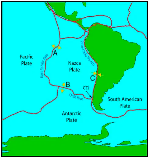
The map above shows three tectonic plate boundaries. Which boundary is responsible for the destruction of Earth’s crust?
Divergent boundary on the Earth’s Pacific Rise
Divergent boundary on the Chile Rise
Convergent boundary on the Peru-Chile Trench
Earth’s crust cannot be destroyed

The image above shows the Nazca plate and the South American plate converging into each other. What geologic formation would you expect to find here?
Plateaus
Rift valleys
Glaciers
Mountains
Plates move at a rate of about 2 ________________ a year.
Millimeters
Kilometers
Centimeters
Meters
What causes crustal plate movements?
Violent volcanic eruptions
Climate change
Changes in Earth’s weather
Convection currents in the Earth’s mantle
What theory explains the seismic activity on Earth?
Convection
Seafloor spreading
Continental drift
Plate tectonics
Volcanoes are found at plate boundaries.
TRUE
FALSE
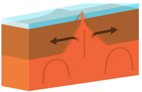
Which type of plate boundary is shown in the photo above?
Divergent
Transform
This is not a plate boundary
Convergent
The Mid-Atlantic ridge is an example of ocean-ocean convergent plate boundary
TRUE
FALSE
The Mid-Atlantic Ridge is an example of what type of location?
Subduction zone
Convergent plate boundary
Transform fault
Divergent plate boundary
At what type of plate boundary are two plates moving apart?
Transform boundaries
Divergent boundaries
Convergent boundaries
What is created with plate divergence after the continental crust splits?
An island arc
An ocean trench
A high mountain
An ocean basin
What does continental rifting lead to?
Island arcs
High mountains
Ocean basins
Ocean trenches
What is the final stage of continental rifting?
An ocean trench
A mountain
An ocean
A gulf
Transform faults _____________
Often offset spreading centers
Involve horizontal movement
Can cut across continents
All of the above
Places where plates slide past each other are called convergent boundaries.
TRUE
FALSE
What happens at transform faults?
Plates pull apart
Plates push together and form mountains
Plates move side-by-side
Plates subduct under each other
At ____________ plate boundaries, crust is neither created nor destroyed.
Convergent
Transform
Divergent
SELECT ALL POSSIBLE ANSWERS:
Which of the following geologic formations can be found at ocean-continent convergent plate boundaries?
Mountains
Island arc
Volcanic arc
Trench
Which plate boundary forms when two plates collide?
Convergent plate boundaries
Divergent plate boundaries
Transform plate boundaries
How many possible combinations of types of plates can meet at a convergent boundary?
Three
Five
Two
Four
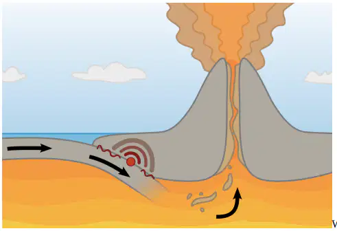
SELECT ALL POSSIBLE ANSWERS:
What geological formation(s) will be created by the ocean-continental plate boundary shown in the diagram above?
Transform fault
Ocean trench
Island arc
Continental arc
What landform is created when two plates of oceanic crust converge?
Continental arc
Hotspot volcano
Island arc
Continental arc
The subduction of one oceanic plate beneath another results in a line of ocean volcanoes called an island arc.
TRUE
FALSE
SELECT ALL POSSIBLE ANSWERS:
Which numbered feature in the image above represents a geologic feature formed from an ocean-ocean convergent plate boundary?
13 - A deep sea trench
15 - An island arc
3 - A single volcano above a hotspot
6 - A continental arc
As two continental plates converge:
Volcanoes grow and erupt
The older, denser crust subducts
Mountains grow upward
All of the above
The Appalachians, which line the eastern coast of the United States, were formed from:
Converging plates as the Pacific Ocean basin closes
Converging plates as the Juan de Fuca Plate subducted beneath the North American Plate
Converging plates when Pangaea came together
Converging plates as the Atlantic Plate subducted beneath the North American Plate
The Himalayas are made when these two plate types converge
Two continental
One oceanic and one continental
Two oceanic
When two continental plates converge, this landform is made:
Mountain range
High plain
Fault zone
Deep valley
The continental margin in Eastern North America has geological activity.
TRUE
FALSE
Eastern North America has a plate boundary.
TRUE
FALSE
Mountain ranges that formed in the geological past, but have not entirely eroded away, are found at __________ margins.
Continental
Active
Passive
As continents come together to form a supercontinent,
The ocean that had separated them disappears
A giant ocean forms on the outside of the supercontinent
Mountain ranges rise where continental plates converge
All of these
SELECT ALL POSSIBLE ANSWERS:
What can the theory of plate tectonics be used to explain?
The formation of forest biomes
The location of ore deposits
The location of mountain ranges
The occurrence of deadly, mild, or no volcanic eruptions in certain regions
Which ocean is spreading due to plate tectonics movement?
Atlantic ocean
Pacific ocean
Arctic ocean
None of the above
Which of the following is NOT affected by the motion of tectonic plates?
Earth's rock cycles
Ocean waves
Evolution of life
Earth's climate
Which volcano lies above the Hawaii hotspot?
Kilauea
Haleakala
Etna
Pinatubo
___________ does not take place at plate boundaries
Tectonic activity
Intraplate activity
Extrapolate activity
Rifting
Hotspot volcanoes are as common on continental crust as on oceanic crust.
TRUE
FALSE

