wayground logo

Free Printable Worksheets

Font size

S
M
L
XL
Worksheets

Study guide 2

Total questions: 163

Worksheet time: 2hrs 2mins

Name
Class
Date
1.

_______   _______ was a hypothesis proposed by Alfred Wegener, where Pangaea broke apart roughly ~200 Ma and shifted to the current position.

a)
Tectonic Plate Theory
b)
Global Warming Theory
c)

Continental Drift

d)
Earthquake Theory
2.

What is Pangaea?

a)
Pangaea was a planet
b)
Pangaea was a type of dinosaur
c)
Pangaea was a famous explorer
d)

Supercontinent (continents fused together)

3.

What was the evidence that supported continental drift hypothesis?

a)
Alignment of the planets
b)
Discovery of new continents
c)
Analysis of ocean currents
d)

•Fit of the continents

Distribution of climate belts (glacier & swamp)

Distribution of fossils

Matching geologic units & mountain ranges

4.

Why was continental drift hypothesis eventually discarded?

a)

Didn’t provide a valid mechanism

b)
There was no evidence to support the hypothesis
c)
Scientists lost interest in the topic
d)
The hypothesis was proven to be entirely false
5.

What is the concept of seafloor spreading?

a)
Seafloor spreading involves the movement of tectonic plates towards each other
b)

Harry Hess (American Professor)

Stretching apart at mid-ocean ridge forms new seafloor by volcanic eruptions.

Old seafloor is subducted at seafloor trenches.

To maintain Earth’s volume, amount of seafloor created at spreading centers must equal amount of seafloor destroyed at trenches in subduction zones.

c)
Seafloor spreading is the process of the Earth's crust sinking into the mantle
d)
Seafloor spreading occurs due to the cooling of the Earth's core
6.

Define Plate Tectonics Theory.

a)
Plate Tectonics Theory explains the formation of clouds in the atmosphere.
b)
Plate Tectonics Theory is related to the study of marine biology.
c)
Plate Tectonics Theory focuses on the behavior of celestial bodies in space.
d)

Lithosphere is broken into a series of plates that move

relative to each other

Move over underlying asthenosphere

7.

What are the three types of plate boundaries?

a)
Divergent boundaries, convergent boundaries, and transform boundaries.
b)
Collision boundaries, sliding boundaries, and rift boundaries.
c)
Subduction boundaries, lateral boundaries, and sliding boundaries.
d)
Tectonic boundaries, sliding boundaries, and fault boundaries.
8.

What is the lithosphere?

a)
The lithosphere is the layer of the atmosphere closest to the Earth's surface.
b)

Earth’s rigid outer shell (crust and uppermost mantle)

c)
The lithosphere is the molten core of the Earth.
d)
The lithosphere is the layer of the Earth where living organisms reside.
9.

What is the asthenosphere?

a)
Solid outer layer of the Earth's mantle
b)

Hotter and weaker rocks of the mantle

Beneath the lithosphere

Allows for gradual motion, slow flow

c)
Liquid layer of the Earth's core
d)
Rigid layer of the Earth's lithosphere
10.

_________ plate boundaries are constructive margins, where

two plates move apart, and the mantle material upwells to

create new seafloor.

a)
Transform
b)
Subduction
c)
Divergent
d)
Convergent
11.

There are two types of divergent plate boundaries

_________ and _________.

a)

Oceanic ridges at mid-ocean spreading centers from

basaltic lava (ex. Mid-Atlantic Ridge)

Continental rifts form at spreading centers within a

continent (ex. East African Rift Valley)

b)
Subduction zones and volcanic arcs
c)
Transform faults and seafloor spreading
d)
Mid-ocean trenches and continental shelves
12.

_________ plate boundaries are destructive margins, where

two plates collide, and the lithosphere is subducted into the

mantle.

a)
Divergent
b)
Transform
c)
Subduction
d)
Convergent
13.

What are the characteristics, features, and examples of

Oceanic-continential convergence ?

a)
Characteristics of oceanic-continental convergence include deserts, coral reefs, and ice caps.
b)
Examples of oceanic-continental convergence are the Sahara Desert and the Great Barrier Reef.
c)
Oceanic-continental convergence is known for its flat terrain, lack of seismic activity, and absence of volcanic activity.
d)

Denser oceanic slab sinks into the asthenosphere at

subduction zones

Pockets of magma develop and rise

Continental volcanic arc forms

Examples include the Andes (Southern America),

Cascades, and the Sierra-Nevadan system (North

America)

14.

What are the characteristics, features, and examples of

Oceanic-oceanic convergence ?

a)
Oceanic-oceanic convergence involves the collision of an oceanic plate with a continental plate, leading to the formation of deep ocean trenches.
b)

Two oceanic slabs converge and one descends beneath

the other

Often forms volcanoes on the ocean floor

Volcanic island arc forms as volcanoes emerge from

the sea

Examples include the Aleutian, Mariana, and Tonga

islands (Pacific Ocean)

c)
Oceanic-oceanic convergence involves the separation of two oceanic plates, leading to the formation of mid-ocean ridges.
d)
Oceanic-continental convergence involves the collision of two oceanic plates, leading to the formation of volcanic island arcs.
15.

What are the characteristics, features, and examples of

continential-continential convergence ?

a)
The process of continential-continential convergence results in the creation of deserts.
b)

Two continents collide during continental collision.

Can produce new mountain ranges such as the Himalayas

c)
Volcanic eruptions are the primary cause of mountain formation.
d)
Continential-continential convergence leads to the formation of deep ocean trenches.
16.

________ plate boundaries are where plates slide past one

another and no new crust is created or destroyed

(earthquakes, but no volcanoes).

a)

Transform fault

b)
Subduction boundaries
c)
Convergent boundaries
d)
Divergent boundaries
17.

A good example of transform fault plate boundaries is the

_____________.

a)
Himalayan Mountains
b)
San Andreas Fault
c)
Mid-Atlantic Ridge
d)
Ring of Fire
18.

What is a hot spot?

a)

Hot mantle material rises via rising

mantle plumes

Core-mantle boundary

Intraplate volcanism

Long-lived volcanic features

Ex: Hawaiian Island Chain and

Yellowstone

b)
A new social media platform
c)
A popular tourist destination
d)
A type of weather phenomenon
19.

Define relative plate velocity.

a)
Color of tectonic plates
b)
Temperature of tectonic plates
c)
Distance between tectonic plates
d)

The motion of a plate with respect to another

20.

Define absolute plate velocity.

a)
Distance between two tectonic plates
b)
Temperature of the Earth's core
c)
Rate of volcanic eruptions
d)

Rate of motion of a lithospheric plate with respect to a fixed reference point

21.

What evidence supports the theory of plate tectonics?

a)
Fossil records of dinosaurs
b)
Global warming patterns
c)
Alignment of the planets
d)

Age & thickness of
sediment

Thin, younger near ridge

Thick, older further away

Hot spots and mantle

plumes

Paleomagnetism

22.

Define paleomagnetism.

a)
The analysis of prehistoric insects
b)
The study of ancient plants
c)
The examination of historical weather patterns
d)

Remnant magnetization of iron- rich minerals (mafic/basaltic) in rocks

Polarity of Earth’s magnetic field is known to have experienced numerous reversal

Record of creation of seafloor

and motion of plates

23.

What is subduction?

a)

At convergent zones, oceanic lithosphere sinks into the

mantle

b)
The process where tectonic plates collide and form a new plate boundary.
c)
The process where tectonic plates slide past each other at a transform boundary.
d)
The process where tectonic plates move apart at a divergent boundary.
24.

What type of rock is oceanic crust composed of?

a)

Basalt, more dense

b)
Granite
c)
Slate
d)
Limestone
25.

What type of rock is continental crust composed of?

a)

ice

b)
Marble
c)

Granite, less dense

d)
Basalt
26.

At a subduction zone, the down-going plate is

composed of what type of crust?

a)
Mantle material
b)
Oceanic crust
c)
Sedimentary rock
d)
Continental crust
27.

What is the main reason for differences in elevation

between continental and oceanic crust?

a)
Difference in color
b)
Variation in temperature
c)
Difference in density
d)
Change in magnetic field
28.

What are the 3 mechanism for plate motion?

a)

Slab-pull

Ridge-push

Convection

b)
Upward boundaries
c)
Sideways boundaries
d)
Parallel boundaries
29.

What is convection?

a)
Convection is the transfer of heat through sound waves.
b)
Convection is the transfer of heat through solid materials.
c)
Convection is the transfer of heat through electromagnetic waves.
d)

Due to Earth’s internal heat

Heat transfer that involves movement

Less dense material rises

More dense material sinks

30.

What is the most important driving factor of plate tectonics?

a)

Slab-pull

b)
Gravitational pull of the moon
c)
Global warming
d)
Magnetic field fluctuations
31.

Is the Earth mostly solid or molten?

a)
liquid
b)
plasma
c)
gas
d)

Solid

32.

Why is the Earth mostly solid even though temperatures

within the Earth are hot enough to melt rock?

a)

Pressure too high

b)
The Earth's magnetic field prevents the rock from melting.
c)
The Earth's atmosphere cools down the interior of the Earth.
d)
The Earth's core is made of a different material that has a higher melting point.
33.

What factors aid in melting solid rock?

a)
High temperature and lack of water
b)
Low temperature and pressure
c)
Low temperature, high pressure, and lack of fluids
d)

Addition of volatiles, especially water

Addition of heat

Decompression

Partial melting

• Heat-transfer melting

34.

Where does decompression melting

occur?

a)
Continental rift zones
b)
Subduction zones
c)
Polar ice caps
d)

Hot spots

Divergent plate

boundaries (continental

rifting & mid-ocean

ridges)

35.

What are the 3 factors that determine the

violence of an eruption?

a)

Composition of the magma

Temperature of the magma

Dissolved gases in the magma

b)
Earthquake intensity, eruption duration, and ash cloud size
c)
Volcano shape, eruption time, and lava color
d)
Magma viscosity, eruption location, and seismic activity
36.

What is the 2 major dissolved gases (volatiles) in magma?

a)
Nitrogen and Oxygen
b)
Sulfur dioxide and Methane
c)
Argon and Helium
d)

Water and carbon dioxide

37.

________ is a measure of a material’s resistance to flow.

a)
Volume
b)
Friction
c)
Density
d)
Viscosity
38.

What does viscosity control?

a)
Density
b)
Pressure
c)

How fast a fluid flows.

d)
Temperature
39.

What is viscosity of magma dependent on?

a)

Temperature

Silica content

Volatile content

b)
Color, shape, and size
c)
Density, pressure, and age
d)
Location, speed, and volume
40.

Melting occurs at subductions zones along convergent plate

boundaries due to what process?

a)
Convection
b)
Erosion
c)
Crystallization
d)

Flux melting

41.

Why does flux melting occur?

a)
Flux melting occurs due to the presence of magnetic fields.
b)
Flux melting occurs due to the impact of solar radiation.
c)

Water acts as a flux

Water lowers the melting temperature

d)
Flux melting occurs due to the rotation of the Earth.
42.

At convergent plate boundaries, what type of volcanic feature

forms?

a)

Continental volcanic arc

Volcanic island arc

b)
Mid-ocean ridges
c)
Hotspots
d)
Shield volcanoes
43.

How does the composition of the magma change with

partial melting?

a)
The composition of the magma becomes more iron-rich with partial melting.
b)

Mixtures of minerals & melting over range of temperatures

Produces magma with higher silica content than original rock

c)
The composition of the magma becomes more water-rich with partial melting.
d)
The composition of the magma becomes more oxygen-rich with partial melting.
44.

What is the active zone of volcanoes that surrounds

the Pacific ocean?

a)
Circle of Flames
b)
Loop of Heat
c)
Band of Inferno
d)
Ring of Fire
45.

What type of basaltic lava resembles

braids in ropes?

a)
Scoria
b)

Pahoehoe lava

c)
Blocky
d)
Aa
46.

What type of basaltic lava

resembles rough, jagged blocks?

a)

Aa lava

b)
Blocky
c)
Ropy
d)
Pahoehoe
47.

These pyroclastic materials are defined as:

a)
Mixture of hot rock fragments, ash, and water ejected during a volcanic eruption
b)
Mixture of hot sand, ash, and gases ejected during a volcanic eruption
c)

Ash/dust-fine, glassy fragments


Pumice-from “frothy” lava

Lapilli-“walnut” size

Cinders-“pea-sized”

d)
Mixture of cold rock fragments, sand, and water ejected during a volcanic eruption
48.

Particles larger than lapilli

a)
Pumice
b)
Volcanic ash
c)

Blocks -hardened lava, angular

Bombs - ejected as hot lava,

aerodynamic

d)
Scoria
49.

Define effusive eruptions.

a)
Effusive eruptions involve explosive release of gases.
b)
Effusive eruptions are characterized by violent volcanic activity.
c)
Effusive eruptions result in the formation of pyroclastic flows.
d)

Low viscosity, basalt

50.

Define explosive eruptions.

a)
Explosive eruptions result in the formation of a caldera.
b)
Explosive eruptions are characterized by a slow and steady flow of lava.
c)

High viscosity, andesite & rhyolite

d)
Explosive eruptions involve the gentle release of rock fragments, ash, and gases.
51.

Define the characteristic of a shield volcano.

a)
Steep, conical shape with explosive eruptions
b)
Narrow, tall structure with slow lava flows
c)
Flat, plateau-like structure with high-viscosity lava
d)

Broad, slightly domed

Made of layers of basaltic (fluid) lava

Effusive eruption

Generally large size

e.g., Mauna Loa in Hawaii

52.

Define the characteristics of a cinder cone.

a)
A cinder cone is a flat volcanic structure with a wide base.
b)
Cinder cones are formed by the cooling of lava flows.
c)

Piles of pyroclastics (mainly lapilli) fountain out of a vent

• Effusive eruption

• Steep slope angle

• Rather small size, less than 300 meter high

• Frequently occur in groups

Define the characteristics of a cinder cone.

d)
They are typically found at convergent plate boundaries.
53.

Define the characteristic of composite cone (or stratovolcano)

a)
Rounded shape with only one type of volcanic material
b)
Completely flat surface with no visible layers
c)

• Most are adjacent to the Pacific Ocean (e.g., Mt. Rainier)

• Explosive eruption

• Large size

• Interbedded lavas and pyroclastic

• Most violent type of activity

d)
Gentle slope with no alternating layers
54.

What is a pyroclastic flow?

a)
A pyroclastic flow is a term used to describe the movement of lava during a volcanic eruption.
b)

• Produced by composite cones

• Fiery pyroclastic flow made of hot gases infused with ash

• Flows down sides of a volcano at rapid speeds, up to 200 km

(125 miles) per hour

c)
A pyroclastic flow is a slow-moving current of cold gas and volcanic matter that flows up the side of a volcano during an eruption.
d)
A pyroclastic flow is a type of cloud formation that occurs after a volcanic eruption.
55.

Define active volcano.

a)

Actively erupting, erupted within the last 10,000 years

b)
A volcano that only erupts during winter months
c)
A volcano that is dormant and will never erupt again
d)
A volcano that has never erupted before
56.

Define dormant volcano.

a)
A dormant volcano is a volcano that is currently active and erupting frequently.
b)
A dormant volcano is a volcano that has never erupted in the past.
c)
A dormant volcano is a volcano that is extinct and will never erupt again.
d)

Active but not currently erupting

57.

Define extinct volcano.

a)

• Can never erupt again

• Completely eroded away, etc.

b)
A volcano that is dormant and expected to erupt soon
c)
A volcano that has never erupted before
d)
A volcano that is currently erupting
58.

What is a volcanic neck?

a)

• Resistant vents left standing after erosion has removed the

volcanic cone

• Shiprock, New Mexico

b)
A volcanic neck is a type of sedimentary rock found near volcanic regions.
c)
A volcanic neck is a type of underground tunnel formed by lava flow.
d)
A volcanic neck is a type of cloud formation caused by volcanic eruptions.
59.

How does a crater differ from a caldera?

a)
A crater is formed by tectonic plate movement, while a caldera is caused by erosion.
b)
A crater is always filled with water, while a caldera is always dry.
c)
A crater is found on land, while a caldera is found underwater.
d)

• Crater is smaller

• Caldera is greater than 1 km in diameter

• Formed by withdraw from magma

chamber and collapse

• Example: Crater Lake

60.

What are some of the short-term indicators of a volcanic

eruption?

a)
Decreased seismic activity, stable ground deformation, no gas emissions
b)
No changes in temperature and water chemistry, increased seismic activity, ground deformation
c)
Increased gas emissions, stable temperature, no seismic activity
d)

• Earthquake activity

• Changes in heat flow

• Gas and steam emission

• Changes in shape

61.

What is a lahar?

a)
A lahar is a type of earthquake.
b)

A volcanic mudflow.

c)
A lahar is a type of glacier.
d)
A lahar is a type of volcanic eruption.
62.

What is intrusive?

a)
Being helpful and considerate
b)
Quiet and unobtrusive
c)
Easily ignored or overlooked
d)

• Formed from magma

• Formed within the Earth

63.

What is extrusive?

a)
Sedimentary rocks formed from magma cooling slowly beneath the Earth's surface
b)
Metamorphic rocks formed from the weathering and erosion of existing rocks
c)

• Formed from lava

• Formed at surface of Earth

d)
Minerals that are only found in deep underground mines
64.

What is a pluton?

a)
A pluton is a type of metamorphic rock.
b)

Underground igneous body

c)
A pluton is a type of volcanic rock.
d)
A pluton is a type of sedimentary rock.
65.

What is a dike?

a)
A dike is a type of dessert made with chocolate.
b)
A dike is a type of musical instrument.
c)

• Tabular intrusion that cross-cuts the surrounding layers of

sedimentary rock

d)
A dike is a type of bird found in tropical regions.
66.

What is a sill?

a)
A type of fruit commonly found in tropical regions.
b)
A vertical piece of wood or stone at the bottom of a window or door frame.
c)
A musical instrument used in traditional Chinese music.
d)

Tabular intrusion that lies parallel to surrounding layers of

sedimentary rock

67.

What is a laccolith?

a)
A laccolith is a type of volcanic crater.
b)

Mushroom (or lens) shape intrusion that form due to inflation

of magma along a sill. It up arches the overlying layers.

c)
A laccolith is a type of metamorphic rock.
d)
A laccolith is a type of sedimentary rock formed by erosion.
68.

How does columnar joining form?

a)
Columnar joining forms by randomly selecting rows from two tables
b)

Shrinking inward in a hexagonal shape while the magma cools.

c)
Columnar joining forms by combining all rows from two tables
d)
Columnar joining forms by matching rows from two tables based on a different column
69.

What are the features of a batholith?

a)
Forms from cooled lava on the Earth's surface
b)
Small mass of extrusive igneous rock
c)

Largest discordant

intrusive body

• Often occur in groups,

where plutons merge

• Surface exposure 100+

square kilometers

• Frequently form the

cores of mountains

d)
Covers less than 10 square kilometers
70.

Can scientist predict earthquakes?

a)
Yes
b)
Sometimes
c)
Rarely
d)

No reliable way to predict earthquake in short-term or long-term.

71.

Where are the majority of earthquakes distributed?

a)

• Tectonic plates boundaries

• Shallow: Transform & divergent boundaries

• Shallow, intermediate, deep, ultra-deep: Convergent

boundaries

b)
In the middle of tectonic plates
c)
At the poles
d)
In the Earth's core
72.

What 2 zones have the greatest amount of seismic activity?

a)
Andes Subduction Zone, Great Rift Valley
b)
Himalayan Frontal Thrust, East African Rift
c)
Mid-Atlantic Ridge, San Andreas Fault
d)

Circum-Pacific belt

Alpine-Himalayan Belt

73.

The _______ is the point within Earth where an earthquake takes

place.

a)
mantle
b)
epicenter
c)

Focus (hypocenter)

d)
crust
74.

The ________ is the point on the surface of the Earth that lies

vertically above the focus.

a)
center
b)
midpoint
c)
epicenter
d)
vertex
75.

Define earthquakes.

a)
Earthquakes are man-made disasters caused by human activities.
b)
Earthquakes are a type of weather phenomenon that occurs in the atmosphere.
c)

Shaking of the Earth caused by the rapid release of energy

caused by a sudden deformation within the Earth

d)
Earthquakes are a result of volcanic eruptions.
76.

Define fault.

a)
A fault is a type of cloud formation.
b)

• Fractures along which sliding or slip takes place

• Rock on opposite sides is offset by an earthquake-induced slip

c)
A fault is a musical term for a mistake in a performance.
d)
A fault is a synonym for a mountain range.
77.

Define displacement.

a)
Displacement is the mass of an object.
b)
Displacement is the force acting on an object.
c)

Quantity of motion that occurs along a fault

d)
Displacement is the speed of an object.
78.

Define seismograph.

a)
A device used to measure wind speed
b)
A tool for tracking ocean currents
c)
An apparatus for counting tree rings
d)

• Machine that measures the

size of earthquakes.

79.

Define seismogram.

a)
A seismogram is a type of geological map.
b)
A seismogram is a type of weather forecasting tool.
c)
A seismogram is a type of musical instrument.
d)

Record created by earthquakes waves

80.

How do scientist locate the epicenter of an earthquake?

a)
Counting the number of aftershocks following the earthquake
b)
Analyzing the cloud formations above the earthquake site
c)
Measuring the temperature changes in the Earth's crust
d)

• Use the difference between the P & S waves to determine

distance to epicenter (360 degrees)

• Three seismic station needed to locate epicenter

81.

What are the defining characteristics of P-waves?

a)
Waves that can only travel through liquids.
b)

• Push-pull (compressional)

motion

• Travel through solids,

liquids, and gases

• Fastest velocity

• Body waves

c)
Slowest seismic waves that can only travel through solids.
d)
Waves that are not related to seismic activity.
82.

What are the defining characteristic of S-waves?

a)

• “Shake” motion

• Travel only through

solids

• Slower velocity than P

waves

• Body waves

What are the defining characteristic of S-waves?

b)
Move particles in a zigzag pattern and can travel through gases
c)
Move particles in a circular motion and can travel through solids
d)
Move particles parallel to wave direction and can travel through liquids
83.

What are the defining characteristic of surface waves?

a)
Travel through the Earth's core
b)

• Greatest destruction

• Travel at the slowest

velocity

What are the defining characteristic of surface waves?

c)
Fastest type of seismic waves
d)
Only have horizontal motion
84.

What are the defining characteristic of Rayleigh (R) waves?

a)
P waves, vertical motion, slow seismic waves
b)
Love waves, linear motion, medium speed seismic waves
c)

• Vertical undulation

• Like ocean wave

d)
Body waves, circular motion, fastest seismic waves
85.

What are the defining characteristic of Love (L) waves?

a)
Vertical, up-and-down motion and fastest seismic waves
b)
Circular motion and medium speed seismic waves
c)
Diagonal, zigzag motion and medium speed seismic waves
d)

Side-to-side motion

• Damaging to building

foundations

86.

List some hazards that can occur from an earthquakes.

a)
Wildfires
b)
Hurricanes
c)

• Ground shaking and displacement

• Landslides

• Sediment liquefaction

• Fire (pipes broken)

• Tsunamis

• Disease

d)
Volcanic eruption
87.

Define tsunami

a)
A tsunami is a type of cloud formation
b)
A tsunami is caused by excessive rainfall
c)

Sea wave generated by a displacement of water.

d)
A tsunami is a result of high tides
88.

Define liquefaction.

a)

• Water saturated soil that mobilizes during an earthquake

and behaves more like a fluid.

b)
Compacted soil that fractures during an earthquake
c)
Waterlogged soil that expands during an earthquake
d)
Dry soil that solidifies during an earthquake
89.

What major factors determine structural damage caused

during an earthquake?

a)

• Intensity/magnitude of the earthquake

• Duration of the vibrations

• Nature of the material upon which the

structure rests

• Design of the structure

b)
Population density, traffic congestion, noise pollution
c)
Distance from the equator, ocean currents, cloud cover
d)
Wind speed, humidity levels, temperature
90.

How did scientist gain knowledge of our Earth’s interior?

a)

• Behavior of P and S waves as travel through the Earth

b)
Volcano eruptions
c)
Satellite imagery
d)
Weather patterns
91.

What are the different layers of the Earth?

a)
crust, core, mantle, inner core
b)
outer core, crust, inner core, mantle
c)
mantle, crust, inner core, outer core
d)

• Crust (surface)

• Mantle

• Outer Core

• Inner Core (center)

92.

Which layer makes up 80% of the Earth?

a)
outer core
b)
mantle
c)
crust
d)
core
93.

What is the composition of the mantle?

a)
Carbonate rocks rich in magnesium and iron, with some aluminum and calcium
b)
Metallic rocks rich in silicon and oxygen, with some nitrogen and sulfur
c)

• Peridotite (olivine)

d)
Silicate rocks rich in gold and silver, with some copper and zinc
94.

What is the composition of the core?

a)
Silicon, Aluminum, Calcium, Magnesium
b)
Hydrogen, Helium, Lithium, Beryllium
c)

• Iron and nickel alloy

d)
Gold, Silver, Platinum, Copper
95.

What state is the inner core?

a)
Solid
b)
Liquid
c)
Gas
d)
Plasma
96.

Why are S-waves unable to pass through the Earth's outer

core?

a)
S-waves lose energy before reaching the outer core
b)
S-waves are absorbed by the Earth's crust
c)

Outer core is liquid

• S-wave shadow zone

d)
S-waves are deflected by the Earth's magnetic field
97.

_________ is based on the measuring amplitude of the

seismic waves.

a)

• Magnitude

b)
Astronomy
c)
Meteorology
d)
Geology
98.

The ___________ is measured using the amplitude of the

_________ seismic wave. But does not estimate adequately the

size of very large earthquakes.

a)

Richter scale, largest

b)
Epicenter
c)
Frequency
d)
Intensity
99.

What 2 factors are Moment Magnitude based on?

a)
Seismic moment and depth of the earthquake
b)
Epicenter location and duration of the earthquake
c)
Magnitude of the earthquake and time of occurrence
d)

• Amplitude

• Displacement

100.

Define seismic risk assessment.

a)

• Long-term prediction method

• Estimate the probability that an earthquake will happen

during a specified period of time

b)
Seismic risk assessment focuses on evaluating the risks of hurricanes.
c)
Seismic risk assessment involves assessing the risks of tornadoes.
d)
Seismic risk assessment is the study of volcanic eruptions.
101.

Define recurrence interval.

a)
The time between two unrelated events
b)
The time between two similar events
c)
The time between two opposite events
d)

Average time between earthquakes

102.

What is evidence used in paleoseismology?

a)
Tree ring dating
b)
GPS monitoring
c)
Volcanic eruption analysis
d)

• Offset layers

• Sand volcanoes

103.

Define uplift.

a)
A decrease in value or deterioration in a particular aspect.
b)
A horizontal movement.
c)

• Upward movement

• Produces mountains

d)
A sudden change in direction.
104.

Define subsidence.

a)
The rapid growth of an area of land.
b)

• Downward movement

• Produces basins

c)
The process of water seeping into the ground.
d)
The expansion of a city's infrastructure.
105.

What drives uplift and subsidence?

a)

Plate tectonics, internal energy

b)
Ocean currents
c)
Volcanic eruptions
d)
Weather patterns
106.

Define mass wasting.

a)
Mass wasting is the movement of water through rocks.
b)
Mass wasting is the process of rock formation.
c)
Mass wasting is the growth of vegetation on slopes.
d)

Gravity-driven movement of materials downslope from higher

elevations to lower elevations

107.

Define weathering.

a)

Chemical and physical weathering break rock apart.

b)
Weathering is the process of solidifying rocks, soil, and minerals through exposure to the Earth's atmosphere, water, and biological organisms.
c)
Weathering is the process of heating rocks, soil, and minerals through exposure to the Earth's atmosphere, water, and biological organisms.
d)
Weathering is the process of creating rocks, soil, and minerals through exposure to the Earth's atmosphere, water, and biological organisms.
108.

Define erosion.

a)

Movement or transport of material due to a mobile agent (running

water, waves, wind, ice, etc.)

b)
Erosion is the process of building up rocks and soil by natural forces.
c)
Erosion is the process of freezing rocks and soil by natural forces.
d)
Erosion is the process of creating new rocks and soil by natural forces.
109.

What is physical (mechanical) weather?

a)
Physical weather is related to the growth of plants and trees.
b)
Physical weather refers to the process of predicting earthquakes.
c)
Physical weather involves the study of rocks and minerals.
d)

• Breaking of rocks into smaller pieces

110.

What is chemical weathering?

a)

• Chemical transformation of rock into one or more new compounds

b)
Chemical weathering is the result of volcanic activity.
c)
Chemical weathering is caused by excessive sunlight exposure.
d)
Chemical weathering is the process of physical erosion on rocks.
111.

What is the relationship between physical and chemical

weathering?

a)
Physical weathering only occurs in cold climates, while chemical weathering only occurs in warm climates.
b)
Physical weathering changes the color of rocks, while chemical weathering breaks them into smaller pieces.
c)
Physical weathering breaks down rocks into smaller pieces without changing their chemical composition, while chemical weathering alters the chemical composition of rocks.
d)
Physical weathering is caused by living organisms, while chemical weathering is caused by natural disasters.
112.

What powers external processes?

a)

Solar Radiation

b)
Internal power source
c)
Magnetic fields
d)
Psychic energy
113.

What powers internal processes?

a)

Earth’s interior energy

b)
Energy derived from sunlight
c)
Energy derived from water
d)
Energy derived from food
114.

How does the angle of repose vary for different materials?

a)
The angle of repose is determined by color
b)
The angle of repose is only affected by temperature
c)
The angle of repose is the same for all materials
d)
The angle of repose varies for different materials based on factors such as particle size, shape, and surface roughness.
115.

What is the relationship to water and sand particle

cohesion?

a)
Sand particles exhibit cohesion with each other, while water molecules do not exhibit cohesion with sand particles.
b)
Water molecules and sand particles exhibit cohesion with each other.
c)
Water molecules exhibit adhesion with sand particles.
d)
Water molecules exhibit cohesion with each other, while sand particles do not exhibit cohesion with water molecules.
116.

What are mass wasting triggers?

a)
Conditions that prevent mass wasting from occurring
b)
Factors that decrease the likelihood of mass wasting events
c)
Events that promote the stability of slopes
d)

• Saturation of the material with water

• Oversteepening of slopes

• Water pressure

• Removal of anchoring vegetation

• Ground vibrations from earthquakes

• Weathering

• Removal of material at base of slope

117.

What climate has the highest chemical weathering rates?

a)

• Hot, wet climates

b)
Temperate climates
c)
Desert climates
d)
Arctic climates
118.

Define slump.

a)
A form of concrete consistency where the concrete expands rapidly.
b)
A form of concrete consistency where the concrete hardens instantly.
c)
A form of concrete consistency where the concrete turns into a gas.
d)

• Mass wasting that occurs when a relatively coherent rock or

regolith block moves along a concave-up, curved surface

119.

Define mudflow.

a)
Mudflow is a type of volcanic eruption.
b)
Mudflow is a type of glacier movement.
c)

• Saturated regolith or soil containing up to 30% water mixed with

mostly clay (fine-grain material) that flows down a slope

d)
Mudflow is a type of earthquake phenomenon.
120.

Define debris flow.

a)

• A mudflow that contains cobbles and boulders suspended in the mud

b)
Debris flow is a type of glacier movement
c)
Debris flow is caused by wind erosion
d)
Debris flow is a type of volcanic eruption
121.

Define rock slide.

a)

Mass of rocks detaches from it substrate on a inclined failure

surface and moves downslope.

b)
A rock slide is a type of erosion where rocks are carried away by wind.
c)
A rock slide is a type of earthquake that causes rocks to tumble down a slope.
d)
A rock slide is a type of avalanche caused by volcanic activity.
122.

Define lahar.

a)

• Mudflows or debris flows associated with volcanoes that

consist of a mixture of volcanic ash, pyroclastic debris,

and water

b)
A type of desert wind
c)
A type of volcanic rock
d)
A type of snow avalanche
123.

What is creep?

a)
Creep is the rapid expansion of materials under constant stress.
b)
Creep is the sudden contraction of materials under constant stress.
c)
Creep is the immediate recovery of materials under constant stress.
d)

• Slow downslope movement of regolith.

124.

What are some of indications that creep is occurring in this
area?


a)
Flowers blooming in the area
b)
Birds chirping loudly
c)
Signs of creep include cracks in the ground, tilted trees or structures, and uneven terrain.
d)
Smooth and even ground surface
125.

How much of the Earth’s water is saline?

a)
50%
b)

97%

c)
75%
d)
85%
126.

How much of the Earth’s water is freshwater?

a)
10%
b)
5%
c)
15%
d)
2.5%
127.

What percentage of freshwater is frozen in glaciers and ice caps?

a)
82.3%
b)

69%

c)
33.5%
d)
45%
128.

What is the hydrologic cycle?

a)

Transfer of water around the Earth System from one reservoir

to another

b)
The hydrologic cycle is the rotation of the Earth on its axis.
c)
The hydrologic cycle is the process of rock formation.
d)
The hydrologic cycle is the movement of air in the atmosphere.
129.

What is precipitation?

a)
Precipitation is the name of a specific type of cloud formation.
b)
Precipitation refers to the movement of clouds in the sky.
c)
Precipitation is the process of water evaporating from the ground.
d)

Rain, sleet, snow or ice fall from clouds to land surface

130.

What is runoff?

a)
A type of bird
b)
A type of shoe
c)
A type of dessert
d)

• Water flows over land surface

• Flows into rivers, lakes, and the ocean

131.

What is infiltration?

a)

Water seeps or percolates into the ground

b)
Plants absorbing nutrients
c)
Air entering the soil
d)
Water leaving the soil
132.

What is evaporation?

a)

Liquid water changing into a gas

b)
Evaporation is the process by which a solid turns into a gas.
c)
Evaporation is the process by which a gas turns into a solid.
d)
Evaporation is the process by which a gas turns into a liquid.
133.

Define drainage basin.

a)

Overall region that is drained or contributes water to a river

system

b)
A drainage basin is a type of dessert
c)
A drainage basin is a type of mountain range
d)
A drainage basin is a type of kitchen sink
134.

Define divide.

a)

• Boundary between drainage basins, high point

b)
To subtract
c)
To increase in size or amount
d)
To combine into one whole
135.

What is base level?

a)
The highest level of a hierarchical structure or system.
b)
A level in the middle of a hierarchical structure or system.
c)
The average level of a hierarchical structure or system.
d)

• Ultimate base level: sea level

• What streams are eroding down to

136.

Which results in a change in base level?

a)

• Uplift of land surface
• Drop of sea level

b)
Volcanic eruption
c)
Global warming
d)
Tectonic subsidence
137.

What are the three zones in a river system and

the characteristics?
a)
Upper zone, middle zone, lower zone
b)
Mountain zone, valley zone, delta zone
c)
Source zone, transition zone, and floodplain zone
d)
Initial zone, intermediate zone, final zone
138.

Which drainage network is this?

a)
The Ganges River
b)
The Nile River
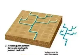
c)

Rectangular (forms jointed bedrock)

Which drainage network is this?
d)
The Amazon River
139.

Which drainage network is this?

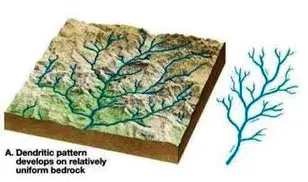
a)

Dendritic (uniform bedrock, gentle slope)
b)
Rectangular drainage network
c)
Radial drainage network
d)
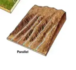
Parallel drainage network
140.

Which drainage network is this?

a)
River drainage network
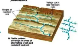
b)

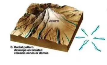
Trellis (alternating resistant/weak rock)
c)
Street drainage network
d)
Sewer drainage network
141.

Which drainage network is this?

a)
Sewer drainage network
b)

Radial (high point in middle)

c)
Street drainage network
d)
River drainage network
142.

Which drainage network is this?

a)
Ocean drainage network
b)
Lake drainage network
c)
River drainage network
d)

Parallel (uniform bedrock with slope)

143.

Define meandering stream.

a)
A meandering stream is a stream that flows in a perfectly circular path.
b)
A meandering stream is a straight watercourse with no bends.
c)
A meandering stream is a stream that flows in a zigzag pattern.
d)

•Snake-like curves in a stream channel

144.

Define braided stream.

a)
A braided stream is a type of river channel that consists of a series of waterfalls.
b)

•Consist of a series of intertwined channels that are overloaded with

coarse-grain sediment.

c)
A braided stream is a type of river channel that consists of a network of large channels separated by permanent islands.
d)
A braided stream is a type of river channel that consists of a single straight channel with no islands.
145.

What is a meander that is still filled with water that is cut off and

isolated from the main channel?

a)
Oxbow lake
b)
Curve pond
c)
Twist reservoir
d)
Bend lake
146.

What is competence?

a)
Inability to do something successfully
b)
Lack of skill or knowledge
c)

Maximum particle size that a stream can carry.

d)
Indifference towards a task
147.

What is capacity?

a)

Total quantity of sediment a stream can carry

b)
Capacity is the exact amount that something can contain or produce.
c)
Capacity is the average amount that something can contain or produce.
d)
Capacity is the minimum amount that something can contain or produce.
148.

What is discharge?

a)

Volume of water in a channel passing a point in one second.

b)
The movement of water through soil layers
c)
The process of converting water into steam
d)
The accumulation of sediment in a riverbed
149.

How are sediments transported in the stream?

a)
Deposition, convection, evaporation
b)

•Dissolved load (invisible)

•Suspended load (suspended, clay & silt)

•Bed load (move along bed, sand to boulder)

c)
Condensation, infiltration, percolation
d)
Weathering, compaction, crystallization
150.

Define Aquifer.

a)
A type of cloud formation
b)

•Sediment or rock with high porosity and permeability

c)
A species of marine fish
d)
A method of water purification
151.

Define Aquitard.

a)
Aquitard is a term used in computer programming to describe a slow processing speed.
b)
Aquitard is a brand of bottled water known for its high mineral content.
c)

•Sediment or rock with relatively low permeability;

relatively impermeable layer of rock or sediment

d)
Aquitard is a type of fish found in the Atlantic Ocean.
152.

Define Porosity.

a)
Porosity is the measure of weight of a material.
b)
Porosity is the measure of temperature in a material.
c)
Porosity is the measure of density in a material.
d)

•Total volume of open space within a material specified

as a percentage

153.

Define Permeability.

a)
Permeability is the process of converting solids into liquids.
b)
Permeability is the ability of a material to change color.
c)
Permeability is the measurement of electrical resistance.
d)

•Ability of a material to allow fluids to pass through an

interconnected network of pores

154.

What are some of the issues of groundwater use?

a)
Erosion
b)

•Contamination

•Heavy pumping

•Subsidence

c)
Drought
d)
Overabundance
155.

Why does flooding tend to be worse in heavily populated

areas?

a)
Increased vegetation leading to more water absorption
b)
Decreased population density causing less impact
c)
Improved urban planning reducing flood risk
d)

•Impervious cover, parking lot & roads

•Does not allow water to infiltrate into ground

•Follows into river and goes overbank faster

156.

What is a flowing artesian well?

a)
A flowing artesian well is a well where water is manually pumped to the surface
b)

Water in the well rises higher than the initial groundwater

level without pumping

c)
A flowing artesian well is a well where water flows due to gravity
d)
A flowing artesian well is a well where water is stored in an underground tank
157.

Define water table.

a)
The water table is the level at which water evaporates from the ground.
b)
The water table is the level at which water freezes in the ground.
c)

• Top of the saturated zone

d)
The water table is the level above which the ground is saturated with water.
158.

When large quantities of water is pumped from a well, a lowering

of the water table is produced. What is this depression called?

a)
sinkage
b)
depletion
c)
reduction
d)

• Cone of depression

159.

What are some features associated with Karst topography?

a)
Volcanic eruptions, lava flows, geysers
b)
Deserts, sand dunes, oases
c)

•Limestone bedrock dissolved by groundwater

•Caves/caverns

•Sinkholes formed from cavern collapse

•Disappearing streams

•Perhaps artesian wells

d)
Glaciers, icebergs, ice caves
160.

What are speleothems that hang from the ceiling of cavern?

a)
stalactites
b)
stalagmites
c)
flowstones
d)
helictites
161.

What are speleothems that grow upward from the ground of a
cavern?

a)
underground icicles
b)
stalagmites
c)
stalactites
d)
cave flowers
162.

What are speleothems called if a stalagmite and stalactite

merge forming a column shape?

a)
column
b)
shaft
c)
pillar
d)
spire
163.

What is the most important erosional agent (even in the desert)?

a)
Fire
b)

Running water

c)
Ice
d)
Wind