
 Worksheets
Final Review Session
Total questions: 150
Worksheet time: 4hrs 19mins
Name
Class
Date
1.

Process 6 is known as...
a)
evaporation
b)
infiltration
c)
condensation
d)
transpiration
2.
Process 5 is known as...
a)
runoff
b)
infiltration
c)
condensation
d)
transpiration
3.
Process 2 is known as...
a)
runoff
b)
infiltration
c)
condensation
d)
transpiration
4.

An increase in precipitation (process 2) will cause an increase in...
a)
transpiration (1)
b)
infiltration (arrows pointing into ground)
c)
condensation (6)
d)
runoff (5)
5.
One way to directly increase runoff is to increase
a)
precipitation
b)
infiltration
c)
condensation
d)
evaporation
6.
One way to directly decrease runoff is to increase
a)
precipitation
b)
infiltration
c)
condensation
d)
evaporation
7.
Porosity is defined as...
a)
The process of water soaking into a soil sample
b)
The ability of a soil sample to permit water to flow through it
c)
The percentage of empty space in a soil sample
d)
What happens to water that cannot soak through a soil sample
8.

Which has a higher porosity?
a)
Sample A
b)
Sample B
c)
They have the same porosity
9.
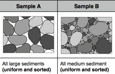
Which has a higher porosity?
a)
Sample A
b)
Sample B
c)
They have the same porosity
10.
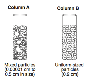
Compared to column A, since B has a greater amount of pore space...
a)
it will have faster rates of infiltration
b)
it will have slower rates of infiltration
c)
It will have the same rate of infiltration
d)
It will have a longer time needed to infiltrate
11.

Compared to sample A, since B has a smaller amount of pore space...
a)
it will have faster rates of infiltration
b)
it will have slower rates of infiltration
c)
It will have the same rate of infiltration
d)
It will have a shorter time needed to infiltrate
12.

The letter with the highest porosity is...
a)
A - loosely packed, well structured soil
b)
B - loosely packed soil with uniform particle size
c)
C - tightly packed soil with uniform particle size
d)
D - tightly packed soil with mixed particle size
13.
The letter with the lowest porosity is...
a)
A - loosely packed, well structured soil
b)
B - loosely packed soil with uniform particle size
c)
C - tightly packed soil with uniform particle size
d)
D - tightly packed soil with mixed particle size
14.
Permeability is defined as...
a)
The process of water soaking into a soil sample
b)
The ability of a soil sample to permit water to flow through it
c)
The percentage of empty space in a soil sample
d)
What happens to water that cannot soak through a soil sample
15.
The letter with the lowest permeability is...
a)
A - loosely packed, well structured soil
b)
B - loosely packed soil with uniform particle size
c)
C - tightly packed soil with uniform particle size
d)
D - tightly packed soil with mixed particle size
16.
The letter with the highest permeability is...
a)
A - loosely packed, well structured soil
b)
B - loosely packed soil with uniform particle size
c)
C - tightly packed soil with uniform particle size
d)
D - tightly packed soil with mixed particle size
17.
Retention is defined as...
a)
The amount of water that is kept within soil after it is drained
b)
The ability of a soil sample to permit water to flow through it
c)
The percentage of empty space in a soil sample
d)
What happens to water that cannot soak through a soil sample
18.
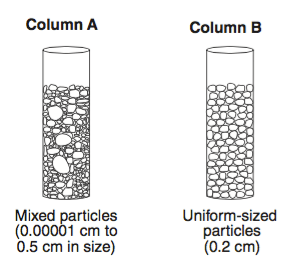
Which has a higher retention?
a)
Sample A
b)
Sample B
c)
They have the same retention
19.

Which has the highest retention?
a)
Sample A - because it has largest pore space
b)
Sample B - because it has uniform sediment sizes
c)
Sample C - because it has uniform sediment sizes
d)
Sample D - because it has smallest pore spaces
20.
When porosity increases, the permeability increases.
This means that there is a(n) ________ relationship between these two variables.
This means that there is a(n) ________ relationship between these two variables.
a)
direct
b)
inverse
21.
When permeability increases, the retention decreases.
This means that there is a(n) ________ relationship between these two variables because ____ _________________________.
This means that there is a(n) ________ relationship between these two variables because ____ _________________________.
a)
direct - an increase in one causes a decrease in the other
b)
inverse - an increase in one causes a decrease in the other
c)
direct - an increase in one causes an increase in the other
d)
inverse - an increase in one causes an increase in the other
22.

Which graph best represents the general relationship between soil particle size and the permeability rate of infiltrating rainwater?
a)
Graph 1
b)
Graph 2
c)
Graph 3
d)
Graph 4
23.

Describe the general relationship between the amount of rainfall and the amount of runoff represented by C.
a)
Direct -
as rainfall increases, runoff decreases
as rainfall increases, runoff decreases
b)
Direct -
as rainfall increases, runoff also increases
as rainfall increases, runoff also increases
c)
Inverse -
as rainfall increases, runoff decreases
as rainfall increases, runoff decreases
d)
Inverse -
as rainfall decreases, runoff also decreases
as rainfall decreases, runoff also decreases
24.
Describe the general relationship between the amount of infiltration and the amount of infiltration represented by B.
a)
Direct -
as infiltration increases, runoff decreases
as infiltration increases, runoff decreases
b)
Direct -
as infiltration increases, runoff also increases
as infiltration increases, runoff also increases
c)
Inverse -
as infiltration increases, runoff decreases
as infiltration increases, runoff decreases
d)
Inverse -
as infiltration decreases, runoff also decreases
as infiltration decreases, runoff also decreases
25.
Which surface soil conditions allow the most infiltration of rainwater?
a)
steep slope and permeable soil
b)
steep slope and impermeable soil
c)
gentle slope and permeable soil
d)
gentle slope and impermeable soil
26.
Physical weathering is defined as...
a)
Wear and tear on rocks primarily by forces.
b)
Wear and tear on rocks primarily by weather.
c)
Wear and tear on rocks primarily by reactions with water.
d)
All of the above.
27.
Chemical weathering is defined as...
a)
Wear and tear on rocks primarily by forces.
b)
Wear and tear on rocks primarily by weather.
c)
Wear and tear on rocks primarily by reactions with water.
d)
All of the above.
28.
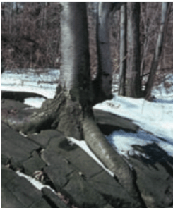
The picture shown is an example of what type of weathering?
a)
Physical - Root Action
b)
Physical - Abrasion
c)
Chemical - Root Action
d)
Chemical - Abrasion
29.
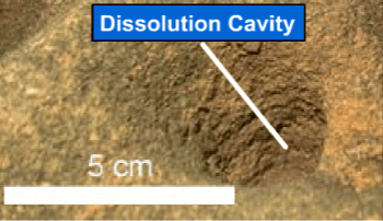
The picture shows a cave made into limestone from acidic rainwater. This is an example of what type of weathering?
a)
Physical - Oxidation
b)
Physical - Carbonation
c)
Chemical - Oxidation
d)
Chemical - Carbonation
30.
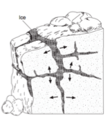
The picture shows ice breaking apart a piece of solid bedrock. This is an example of what type of weathering?
a)
Physical - Frost Action
b)
Physical - Carbonation
c)
Chemical - Frost Action
d)
Chemical - Carbonation
31.
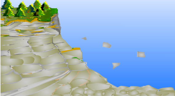
The picture shows rocks falling down a cliff. This is an example of what type of weathering?
a)
Physical - Root Action
b)
Physical - Abrasion
c)
Chemical - Root Action
d)
Chemical - Abrasion
32.
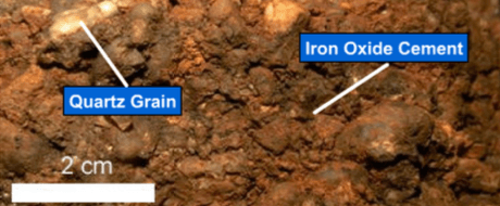
The picture shows rusted iron sediments that were exposed to water. This is an example of what type of weathering?
a)
Physical - Oxidation
b)
Physical - Carbonation
c)
Chemical - Oxidation
d)
Chemical - Carbonation
33.
Physical weathering changes...
a)
the shape AND the composition of rocks.
b)
the shape BUT NOT the composition of rocks.
c)
the composition BUT NOT the shape of rocks.
d)
NEITHER the shape NOR the composition of rocks.
34.
Chemical weathering changes...
a)
the shape AND the composition of rocks.
b)
the shape BUT NOT the composition of rocks.
c)
the composition BUT NOT the shape of rocks.
d)
NEITHER the shape NOR the composition of rocks.
35.
A necessary ingredient for chemical weathering is...
a)
water
b)
carbon dioxide
c)
oxygen
d)
methane
36.
An arid environment is...
a)
dry
b)
humid
c)
moist
d)
high precipitation
37.
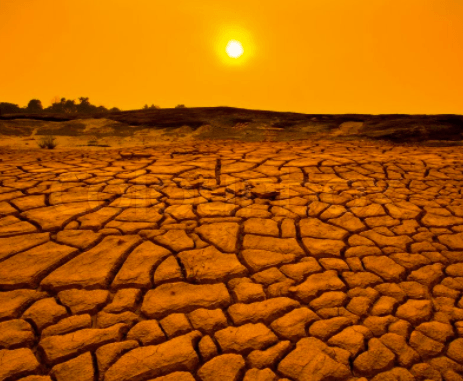
ARID environments may have lots of...
a)
BOTH chemical and physical weathering
b)
physical BUT NOT chemical weathering
c)
chemical BUT NOT physical weathering
38.
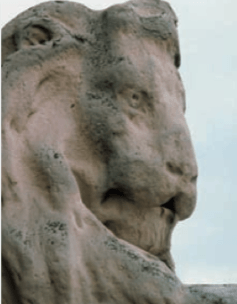
The picture shows a limestone statue that has been weathered. This is an example of what type of weathering?
a)
Physical - Acid Precipitation
b)
Physical - Abrasion
c)
Chemical - Acid Precipitation
d)
Chemical - Abrasion
39.
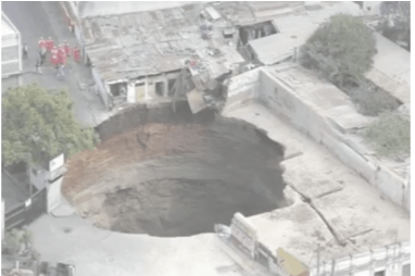
The picture shows a sinkhole that has opened up in limestone bedrock under a city. This is an example of what type of weathering?
a)
Physical - Carbonation
b)
Physical - Abrasion
c)
Chemical - Carbonation
d)
Chemical - Abrasion
40.
The amount of chemical weathering will increase if...
a)
air temperature increases and precipitation decreases
b)
air temperature decreases and precipitation also decreases
c)
air temperature decreases and precipitation increases
d)
air temperature increases and precipitation also increases
41.
The amount of chemical weathering will decrease if...
a)
air temperature increases and precipitation decreases
b)
air temperature decreases and precipitation also decreases
c)
air temperature decreases and precipitation increases
d)
air temperature increases and precipitation also increases
42.
The most chemical weathering will happen when the climate is...
a)
cool and dry
b)
warm and dry
c)
cool and wet
d)
warm and wet
43.
The least chemical weathering will happen when the climate is...
a)
cool and dry
b)
warm and dry
c)
cool and wet
d)
warm and wet
44.
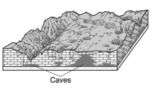
What type of weathering was responsible for the development of these caves?
a)
chemical weathering of limestone
b)
physical weathering of limestone
c)
chemical weathering of sandstone
d)
physical weathering of sandstone
45.
Which activity demonstrates chemical weathering?
a)
freezing of water in the cracks of a sandstone sidewalk
b)
rusting of iron particles in soil
c)
grinding a sediment into powder
d)
abrasion in a stream by tumbling sediments
46.
Resistant to weathering means...
a)
something does not wear down easily
b)
something wears down very easily
c)
something can withstand a lightning strike
d)
something cannot withstand a lightning strike
47.
Not resistant to weathering means...
a)
something does not wear down easily
b)
something wears down very easily
c)
something can withstand a lightning strike
d)
something cannot withstand a lightning strike
48.
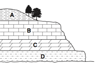
Which layer is MOST resistant to weathering?
a)
Layer A
b)
Layer B
c)
Layer C
d)
Layer D
49.
Which layer is LEAST resistant to weathering?
a)
Layer A
b)
Layer B
c)
Layer C
d)
Layer D
50.

Which layer is LEAST resistant to weathering?
a)
Rockester Shale
b)
Lockport Dolostone
c)
Thorold Sandstone
d)
Whirlpool Sandstone
51.
Which layer is LEAST resistant to weathering?
a)
Rockester Shale
b)
Lockport Dolostone
c)
Thorold Sandstone
d)
Whirlpool Sandstone
52.
Which layer is MOST resistant to weathering?
a)
Rockester Shale
b)
Grimsby Sandstone
c)
Queenston Shale
d)
Whirlpool Sandstone
53.
Process 6 is known as...
a)
evaporation
b)
infiltration
c)
condensation
d)
transpiration
54.
Process 5 is known as...
a)
runoff
b)
infiltration
c)
condensation
d)
transpiration
55.
Process 2 is known as...
a)
runoff
b)
infiltration
c)
condensation
d)
transpiration
56.
Process 2 is known as...
a)
precipitation
b)
infiltration
c)
condensation
d)
transpiration
57.
Process 1 is known as...
a)
precipitation
b)
infiltration
c)
condensation
d)
transpiration
58.
Process 5 is known as...
a)
precipitation
b)
runoff
c)
condensation
d)
transpiration
59.
Process 1 is known as...
a)
precipitation
b)
infiltration
c)
condensation
d)
transpiration
60.

Letter B best corresponds to
a)
precipitation
b)
evaporation
c)
condensation
d)
transpiration
61.
One way to directly increase runoff is to increase
a)
precipitation
b)
infiltration
c)
condensation
d)
evaporation
62.
One way to directly increase runoff is to increase
a)
precipitation
b)
infiltration
c)
condensation
d)
evaporation
63.
One way to directly decrease runoff is to increase
a)
precipitation
b)
infiltration
c)
condensation
d)
evaporation
64.
Porosity is defined as...
a)
The process of water soaking into a soil sample
b)
The ability of a soil sample to permit water to flow through it
c)
The percentage of empty space in a soil sample
d)
What happens to water that cannot soak through a soil sample
65.
Which has a higher porosity?
a)
Sample A
b)
Sample B
c)
They have the same porosity
66.
Which has a higher porosity?
a)
Sample A
b)
Sample B
c)
They have the same porosity
67.
Which has a higher porosity?
a)
Sample A
b)
Sample B
c)
They have the same porosity
68.
The letter with the highest porosity is...
a)
A - loosely packed, well structured soil
b)
B - loosely packed soil with uniform particle size
c)
C - tightly packed soil with uniform particle size
d)
D - tightly packed soil with mixed particle size
69.
The letter with the lowest porosity is...
a)
A - loosely packed, well structured soil
b)
B - loosely packed soil with uniform particle size
c)
C - tightly packed soil with uniform particle size
d)
D - tightly packed soil with mixed particle size
70.
The letter with the lowest permeability is...
a)
A - loosely packed, well structured soil
b)
B - loosely packed soil with uniform particle size
c)
C - tightly packed soil with uniform particle size
d)
D - tightly packed soil with mixed particle size
71.
The letter with the highest permeability is...
a)
A - loosely packed, well structured soil
b)
B - loosely packed soil with uniform particle size
c)
C - tightly packed soil with uniform particle size
d)
D - tightly packed soil with mixed particle size
72.
Permeability is defined as...
a)
The process of water soaking into a soil sample
b)
The ability of a soil sample to permit water to flow through it
c)
The percentage of empty space in a soil sample
d)
What happens to water that cannot soak through a soil sample
73.

Which has a higher permeability?
a)
Sample A
b)
Sample B
c)
They have the same permeability
74.
Which has a higher permeability?
a)
Sample A
b)
Sample B
c)
They have the same porosity
75.
Retention is defined as...
a)
The amount of water that is kept within soil after it is drained
b)
The ability of a soil sample to permit water to flow through it
c)
The percentage of empty space in a soil sample
d)
What happens to water that cannot soak through a soil sample
76.

Which has a higher retention?
a)
Sample A
b)
Sample B
c)
They have the same retention
77.
Which has a higher retention?
a)
Sample A
b)
Sample B
c)
They have the same retention
78.
Which has the highest retention?
a)
Sample A - because it has largest pore space
b)
Sample B - because it has uniform sediment sizes
c)
Sample C - because it has uniform sediment sizes
d)
Sample D - because it has smallest pore spaces
79.
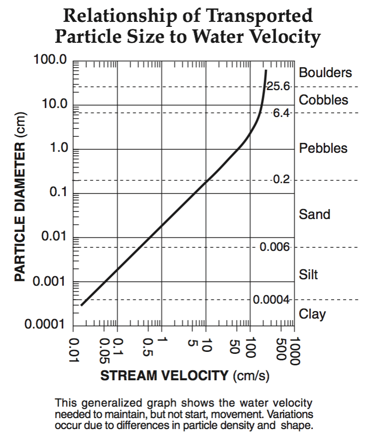
A particle diameter of 0.0007 cm corresponds to which sediment classification?
a)
sand
b)
silt
c)
clay
d)
pebble
80.
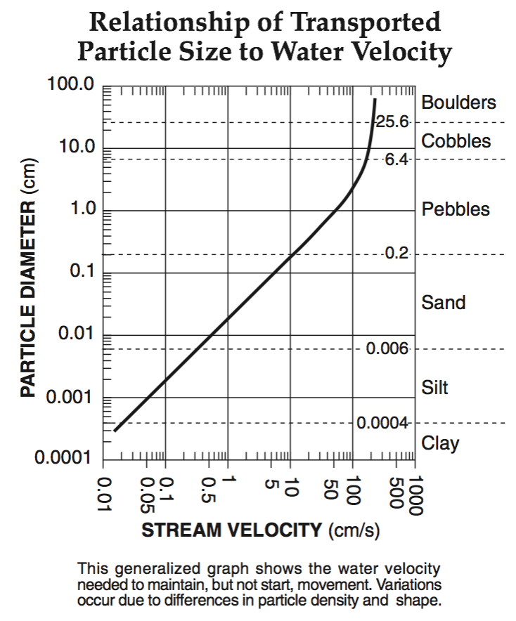
A particle diameter of 0.007 cm corresponds to which sediment classification?
a)
sand
b)
silt
c)
clay
d)
pebble
81.
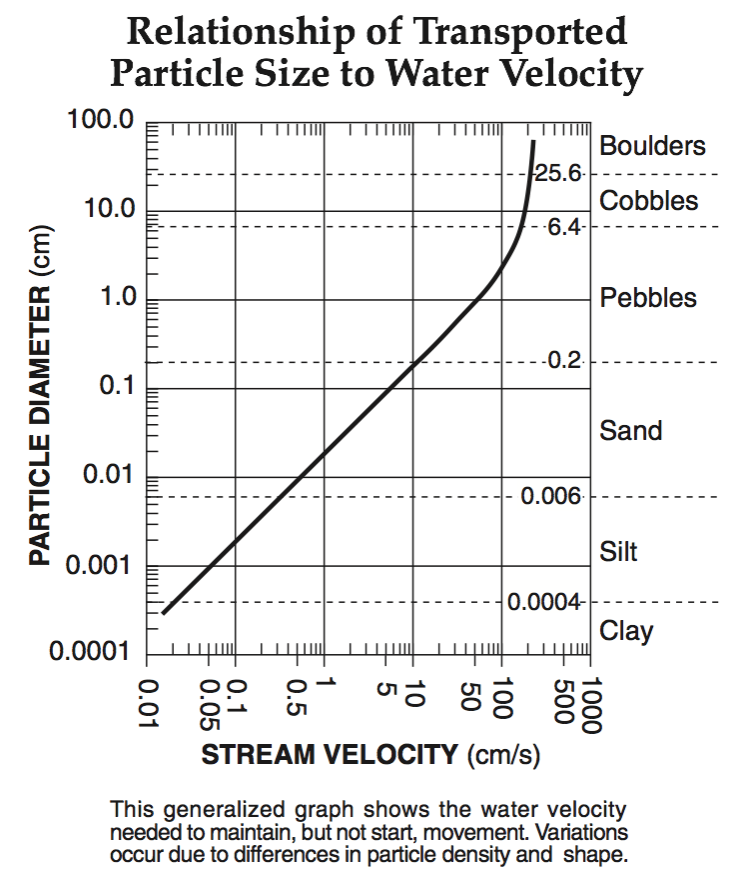
A particle diameter of 0.07 cm corresponds to which sediment classification?
a)
sand
b)
silt
c)
clay
d)
pebble
82.
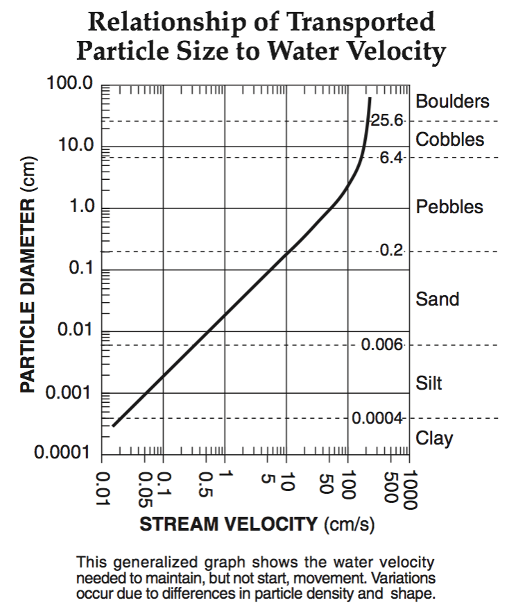
A particle diameter of 0.7 cm corresponds to which sediment classification?
a)
sand
b)
silt
c)
clay
d)
pebble
83.
Forms when a flowing glacier erodes an area between two mountains.
a)
U-Shaped Valley
b)
V-Shaped Valley
c)
Kettle
d)
Moraine
84.
Forms when a flowing river erodes an area between two mountains.
a)
U-Shaped Valley
b)
V-Shaped Valley
c)
Kettle
d)
Moraine
85.
Glaciers often form V shaped valleys
a)
true
b)
false
86.
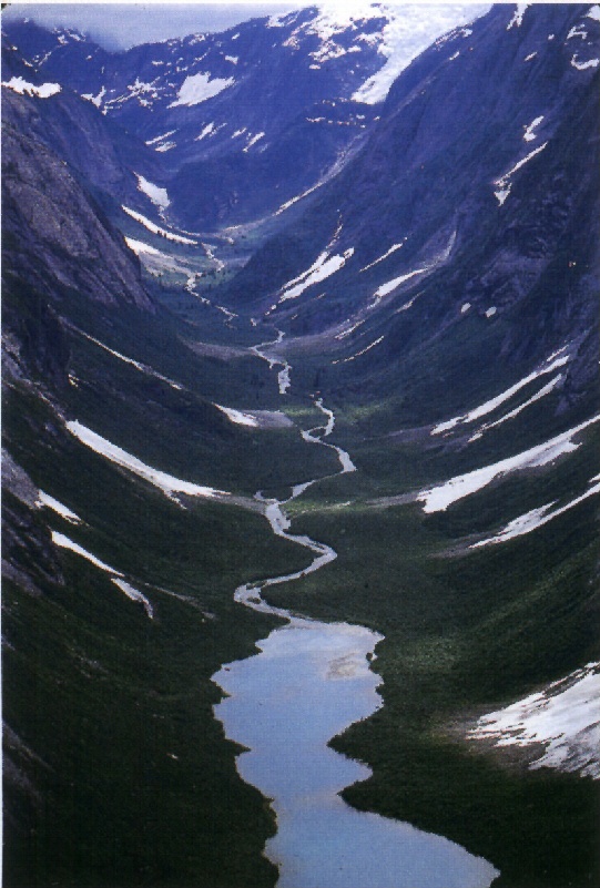
Which agent of erosion created this landform?
a)
Running water
b)
Moving Ice
c)
Wind
d)
Gravity
87.
glacial erosion causes ______ as it moves across the land?
a)
plucking and striations
b)
beaches and sand bars
c)
sea caves and headlands
d)
sand dunes and losses
88.
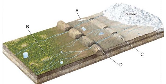
What glacial features are indicated by the labels C and D on the figure?
a)
moraines
b)
outwash plains
c)
kettle lakes
d)
ice sheets
89.
What glacial features are indicated by the label B on the figure?
a)
moraine
b)
outwash plain
c)
kettle lake
d)
ice sheet
90.
What glacial features is likely to form at label A on the figure?
a)
moraine
b)
outwash plain
c)
kettle lake
d)
ice sheet
91.
What is an enormous mass of ice moving over land?
a)
glacier
b)
iceberg
c)
ice wedging
d)
dune
92.
What is an enormous mass of sand being blown by wind?
a)
drumlin
b)
unsorted sediments
c)
ice wedging
d)
dune
93.
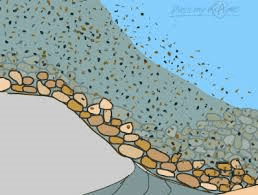
laying down or settling of eroded material
a)
River Abrasion
b)
Dunes
c)
Deposition
d)
Weathering
94.
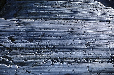
_____ are parallel scratch marks on bedrock
a)
Plucking
b)
Abrasion
c)
Striations
d)
Till
95.
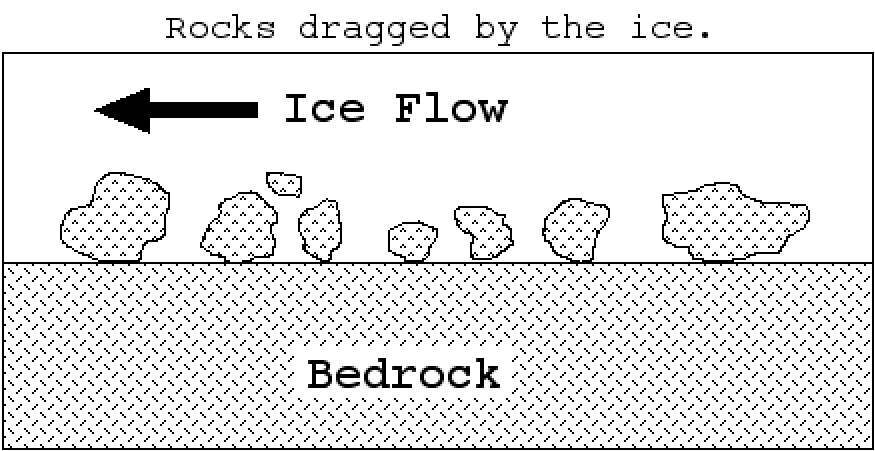
_____ happens when rocks along the base of ice create polishing, grooves and striations.
a)
Plucking
b)
Abrasion
c)
Weathering
d)
Erosion
96.
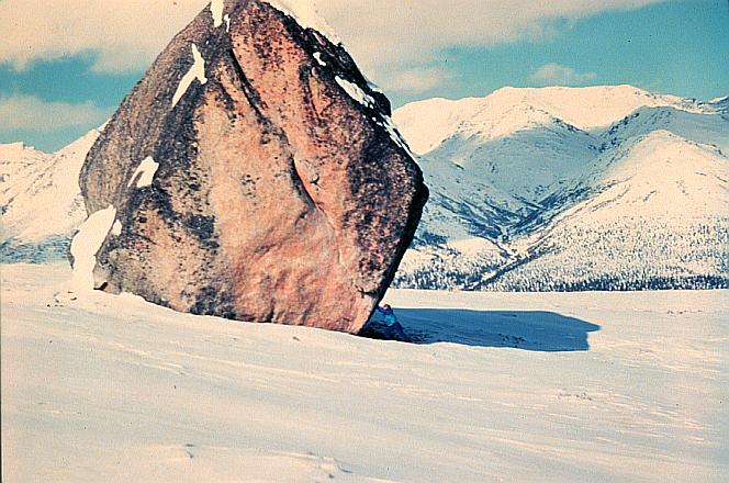
_____ are enormous boulders transported and deposited by glaciers, often far from their source region.
a)
Till
b)
Erratics
c)
Moraines
d)
Drumlins
97.
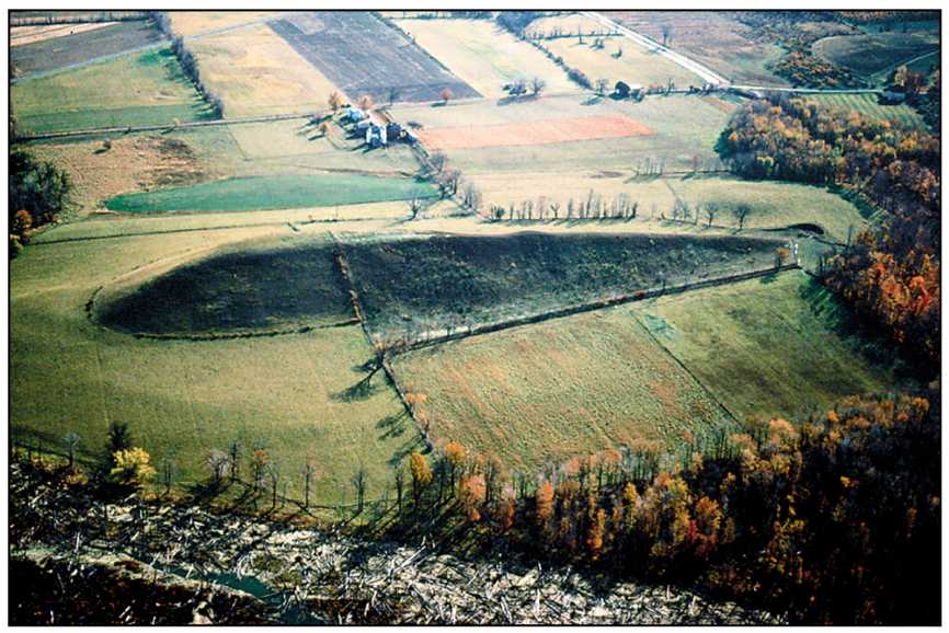
A _____ is a tear-drop-shaped hill created by ice flow over and around till deposit.
a)
drumlin
b)
esker
c)
moraine
d)
erratic
98.
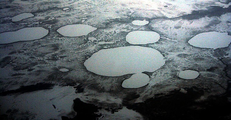
_____ are depressions formed as stranded ice blocks melt in outwash.
a)
erratics
b)
eskers
c)
kettles
d)
drumlin
99.
Hills made of till; taller and steeper on one end than the other; short end points in the direction of glacier movement
a)
outwash plains
b)
kettle lakes
c)
drumlins
d)
eskers
100.
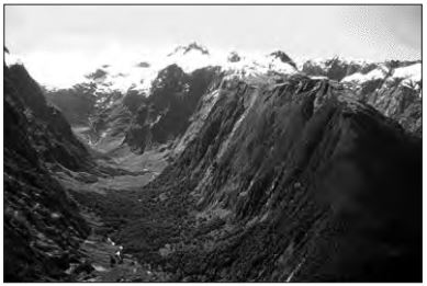
The photograph below shows a valley. Which agent of erosion most likely produced this valley’s shape?
a)
blowing wind
b)
ocean waves
c)
moving ice
d)
running water
101.
How do roots stop erosion?
a)
They block the wind from the soil.
b)
They loosen soil.
c)
They lift up sediment.
d)
They hold sediment into place.
102.
Abrasion by wind-carried sand causes much erosion.
a)
True
b)
False
103.
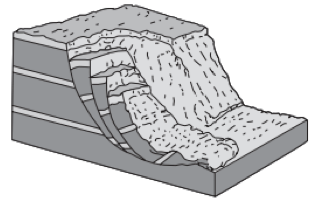
The block diagram below represents a rapid downslope flow of saturated soil and rock layers. What are two likely causes of this rapid downslope flow?
a)
groundwater and abrasion
b)
groundwater and gravity
c)
prevailing wind and abrasion
d)
prevailing wind and gravity
104.
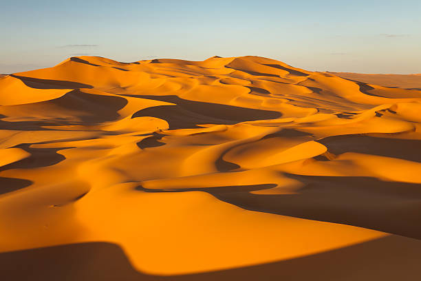
How was this erosional feature created?
a)
wind
b)
ocean
c)
stream river
d)
gravity
105.
Glacial moraine (sediments carried by glaciers) can be described as
a)
sorted and layered
b)
sorted and not layered
c)
unsorted and layered
d)
unsorted and not layered
106.
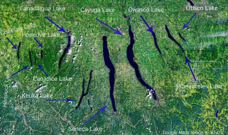
How was this erosional feature created?
a)
running water
b)
moving ice
c)
wave action
d)
mass movement
107.
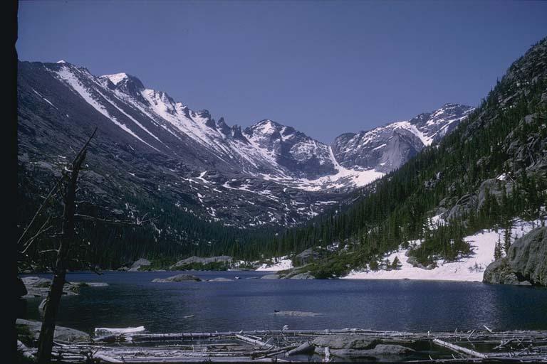
The photograph below shows a U-shaped valley. Which agent of erosion most likely produced this valley’s shape?
a)
blowing wind
b)
ocean waves
c)
moving ice
d)
running water
108.
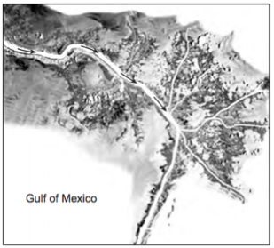
The satellite photograph below shows the Mississippi River entering into the Gulf of Mexico. Arrows show the direction of river flow. This depositional feature in the Gulf of Mexico is best identified as
a)
a delta
b)
a sandbar
c)
a barrier island
d)
an outwash plain
109.
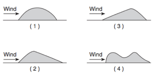
Which diagram represents a side view of a sand dune most commonly formed as a result of the prevailing wind direction shown?
a)
1
b)
2
c)
3
d)
4
110.
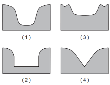
Which cross section best represents the valley shape where a rapidly flowing stream is cutting into the bedrock in a mountainous area?
a)
1
b)
2
c)
3
d)
4
111.
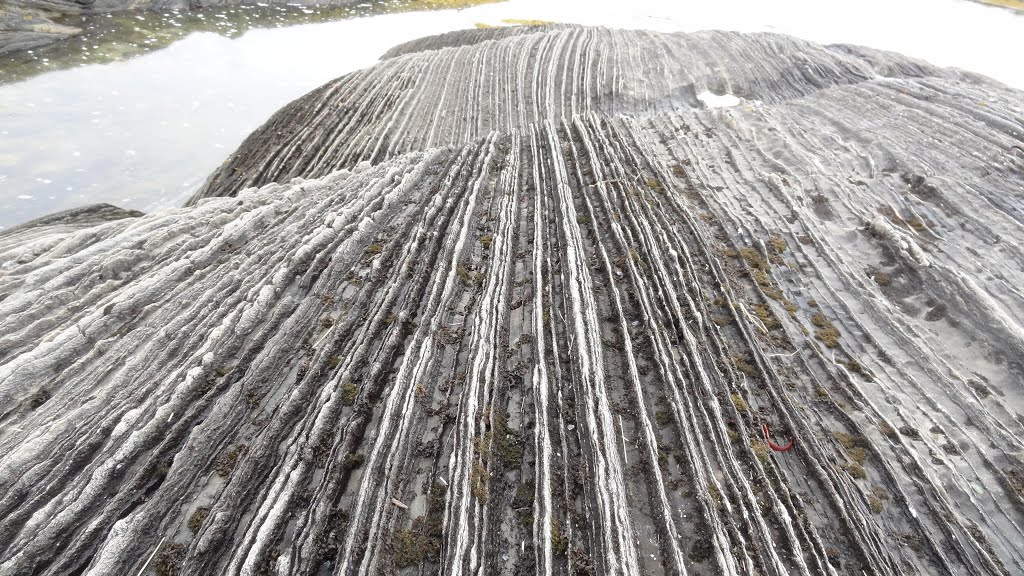
The photograph shows scratched and grooved bedrock. The scratches and grooves were most likely created when
a)
alternating thawing and freezing of water cracked the bedrock
b)
flooding from a nearby lake covered the bedrock
c)
a glacier dragged rocks over the bedrock
d)
rocks from a landslide slid along the bedrock
112.
The natural sandblasting (abrasion) of surface bedrock in a desert region is the result of
a)
wind erosion
b)
wave erosion
c)
mass movement
d)
chemical precipitation
113.
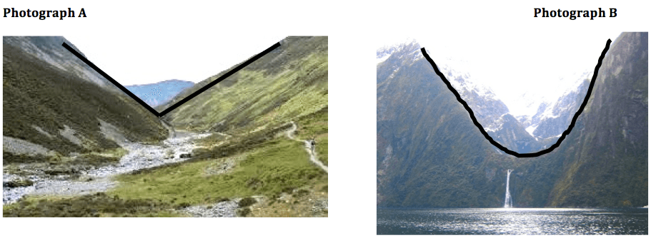
Which list best identifies the agent of erosion that primarily determined the shape of each valley?
a)
photograph A—glacier; photograph B—river
b)
photograph A—river; photograph B—glacier
c)
Both A and B—river
d)
Both A and B—glacier
114.
Which agent of erosion most likely formed the drumlins and finger lakes in New York State?
a)
running water
b)
moving ice
c)
wave action
d)
mass movement
115.
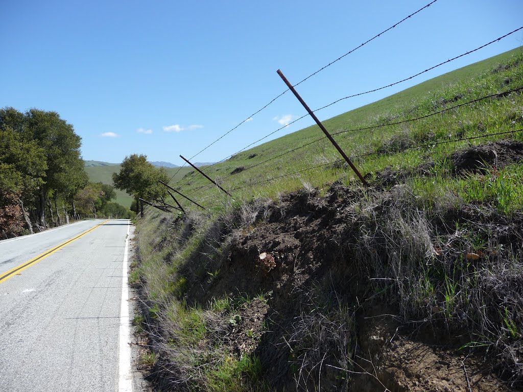
Based on the photograph, which erosional agent had the greatest effect on the structures that humans have built on this landscape?
a)
wind
b)
gravity
c)
glaciers
d)
river
116.
Which erosional force produces avalanches and landslides?
a)
gravity
b)
running water
c)
wind
d)
ocean waves
117.
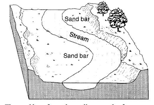
The diagram below shows a portion of a stream. The sand bar formed as a direct result of
a)
erosion due to a decrease in stream velocity
b)
erosion due to an increase in stream velocity
c)
deposition due to a decrease in stream velocity
d)
deposition due to an increase in stream velocity
118.
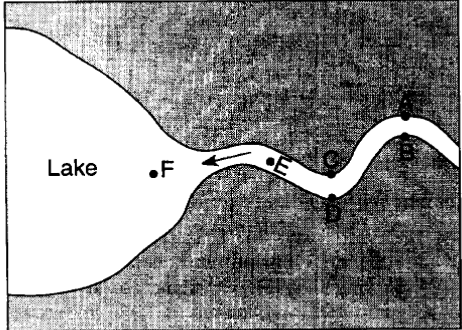
The map below represents a river as it enters a lake.
At which locations is the amount of deposition greater than the amount of erosion?
At which locations is the amount of deposition greater than the amount of erosion?
a)
A,C and E
b)
B, D and F
c)
B, C, and F
d)
A, D and E
119.
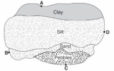
The map below shows an overhead view of sediments that have accumulated at the bottom of a lake. Points A through D represent locations on the shoreline of the lake. A river most likely flows into the lake nearest to location
a)
A
b)
B
c)
C
d)
D
120.
Sediments are deposited in a river delta because the
a)
velocity of the river decreased
b)
force of gravity decreased
c)
volume of the river increases
d)
gradient of the river increases
121.
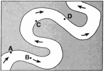
At which location is the greatest amount of sediment most likely being deposited?
a)
A
b)
B
c)
C
d)
D
122.
Trees growing on the edge of a river's meander are most likely to fall into the river due to
a)
deposition on the inside of the meander
b)
deposition on the outside of the meander
c)
erosion on the inside of the meander
d)
erosion on the outside of the meander
123.
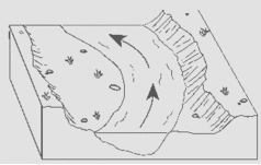
The diagram below shows a section of a meander in a stream. The arrow shows the direction of stream flow. The stream bank on the outside of this meander is steeper than than the stream bank on the inside of this meander because the water on the outside of the meander is moving
a)
Slower, causing deposition
b)
Faster, causing deposition
c)
Slower, causing erosion
d)
Faster, causing erosion
124.
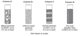
The columns A, B, C, and D shown below contain equal volumes of sediment. When an equal volume of water is added to each column, the greatest rate of infiltration will occur in which column?
a)
A
b)
B
c)
C
d)
D
125.
A stream’s velocity decreases from 100 cm/s to 5cm/s. Which size sediment particles will still be transported by the stream?
a)
pebbles, sand, silt and clay
b)
sand, silt and clay only
c)
silt and clay only
d)
clay only
126.
Flash flooding often occurs in city areas because
a)
runoff decreases during preciptiation
b)
ground water storage is usually very large
c)
roads, pavements and buildings reduce the infiltration of water into the ground
d)
the heat generated by the city areas decreases actual evapotranspiration
127.
During a rainstorm, when the soil becomes saturated, the amount of infiltration
a)
decreases and runoff decreases
b)
decreases and runoff increases
c)
increases and runoff decreases
d)
increases and runoff increases
128.
What is necessary for sand dunes to form?
a)
a loose sand and strong wind
b)
pressure in the Earth
c)
ice glaciers
d)
Gravity
129.
a landform that forms when rivers or glaciers wear away rock and soil
a)
valley
b)
hoodoo
c)
sand dune
d)
canyon
130.
a hill of sand that is deposited by the wind
a)
valley
b)
sand dune
c)
hoodoo
d)
canyon
131.
the movement of weathered materials by water, wind, or ice
a)
weathering
b)
deposition
c)
landform
d)
erosion
132.
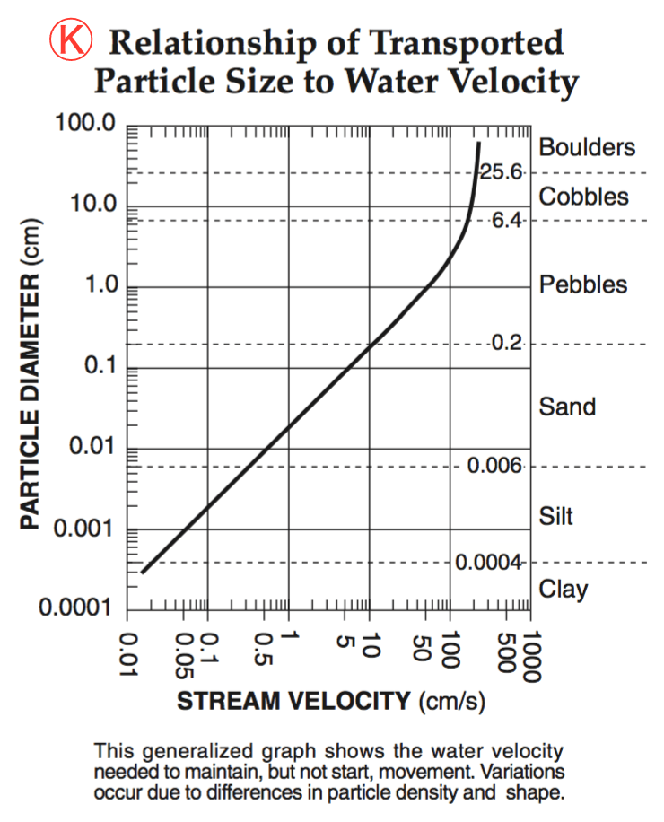
What is the minimum water velocity necessary to maintain movement of 0.1-centimeter-diameter particles in a stream?
a)
5.0 cm/s
b)
0.02 cm/s
c)
0.5 cm/s
d)
20.0 cm/s
133.
What is the minimum water velocity necessary to maintain movement of 0.1-centimeter-diameter particles in a stream?
a)
5.0 cm/s
b)
0.02 cm/s
c)
0.5 cm/s
d)
20.0 cm/s
134.
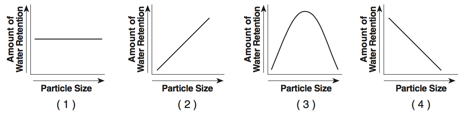
Which graph best indicates the general relationship between soil particle size and the amount of water retention by a permeable soil?
a)
GRAPH 1
b)
GRAPH 2
c)
GRAPH 3
d)
GRAPH 4
135.
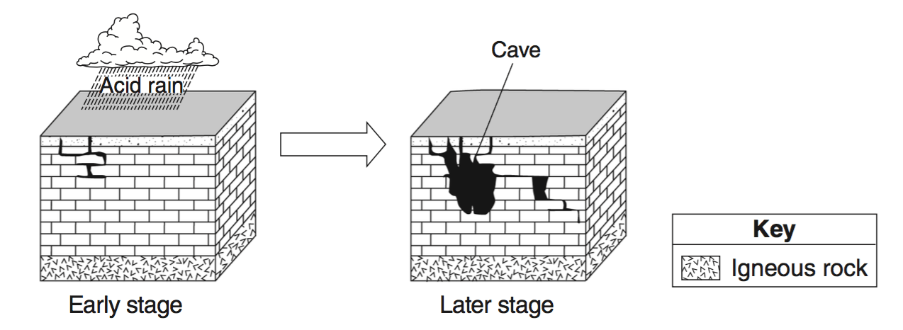
The two block diagrams below represent the formation of caves.
Which types of weathering and erosion are primarily responsible for the formation of caves?
Which types of weathering and erosion are primarily responsible for the formation of caves?
a)
chemical weathering and groundwater flow
b)
chemical weathering and runoff
c)
physical weathering and groundwater flow
d)
physical weathering and runoff
136.

The ozone layer protects life on Earth by absorbing harmful ultraviolet radiation. The ozone layer is located between 17 kilometers and 35 kilometers above Earth’s surface in which atmospheric temperature zone?
a)
troposphere
b)
stratosphere
c)
mesosphere
d)
thermosphere
137.

Which weather map symbol is associated with extremely low air pressure?
a)
SYMBOL 1
b)
SYMBOL 2
c)
SYMBOL 3
d)
SYMBOL 4
138.
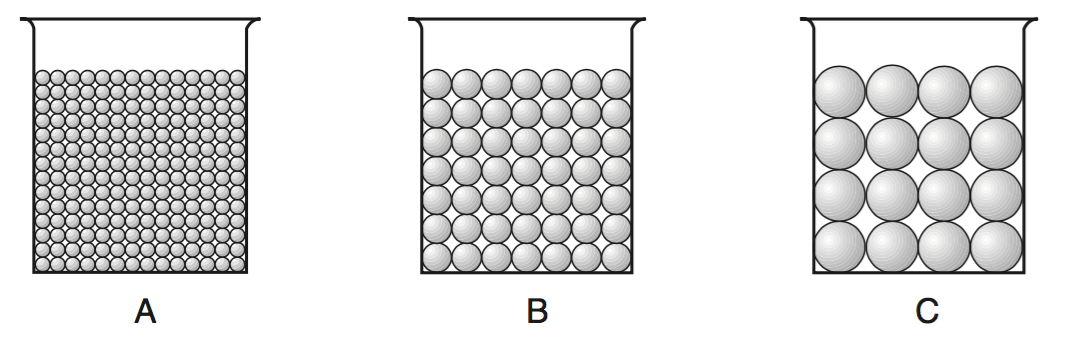
The cross sections below represent three beakers that were used to test porosity. Beakers A, B, and C each contain a different size of bead. Each beaker holds an equal volume of beads. The amount of water needed to fill the total pore space between the beads in each beaker was measured.
Which statement best describes the porosity that was found for these three samples?
Which statement best describes the porosity that was found for these three samples?
a)
A had a greater porosity than B and C.
b)
B had a greater porosity than A and C.
c)
C had a greater porosity than A and B.
d)
All three samples had the same porosity.
139.
Which graph best indicates the general relationship between soil particle size and the amount of water retention by a permeable soil?
a)
GRAPH 1
b)
GRAPH 2
c)
GRAPH 3
d)
GRAPH 4
140.
A meandering stream deposits most of its sediments on the
a)
inside of meanders where the stream flows faster
b)
inside of meanders where the stream flows slower
c)
outside of meanders where the stream flows faster
d)
outside of meanders where the stream flows slower
141.
An elongated hill that is composed of unsorted sediments deposited by a glacier is called
a)
a delta
b)
a drumlin
c)
a sand dune
d)
an outwash plain
142.
Sediment is deposited as a river enters a lake because the
a)
velocity of the river decreases
b)
force of gravity decreases
c)
volume of water increases
d)
slope of the river increases
143.
What is the approximate minimum stream velocity needed to keep a particle in motion that has a diameter of 10 centimeters?
a)
110 cm/s
b)
190 cm/s
c)
325 cm/s
d)
425 cm/s
144.
What is the best evidence that a glacial erratic has been transported?
a)
It is located at a high elevation in a mountainous area.
b)
It is less than 25 centimeters in diameter.
c)
Its composition is different from that of the bedrock under it.
d)
It appears to have been intensely metamorphosed.
145.
What change will a pebble usually undergo when it is transported a great distance by streams?
a)
It will become jagged and its mass will decrease.
b)
It will become jagged and its volume will increase.
c)
It will become rounded and its mass will increase.
d)
It will become rounded and its volume will decrease.
146.
Which is larger, a boulder or cobble?
a)
Boulder
b)
Cobble
147.
What is larger, a pebble or sand?
a)
Pebble
b)
Sand
148.
Which is smaller, sand or silt?
a)
Sand
b)
Silt
149.
Which is smaller, pebble or cobble?
a)
Pebble
b)
Cobble
150.
Which soil particles have the smallest pore spaces between sediments?
a)
Clay
b)
Silt
c)
Sand
100 %

