
 Worksheets
Unit #1 Human Geography: study Guide
Total questions: 62
Worksheet time: 31mins
Which of the following do geographers NOT do?
They identify the location of important places.
They organize material chronologically.
They explain why one human activity is found near another.
They ask where and why.
They organize material spatially.
To explain why different places are interrelated, geographers have three basic concepts
Place, region, and connection
Place, region, and space
Place, scale, space
Scale, space, connection
Scale, space, region
History and geography differ in one especially important matter.
History is a much older discipline than geography.
A geographer can travel to a different place, but a historian cannot travel back in time.
A geographer is limited because most places are inaccessible.
History is constantly changing, but geography remains static.
Geography studies from a temporal perspective while history examines events from a spatial perspective.
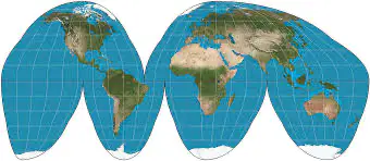
The following projection is a
Mercator projection
Goode Homolosine projection
Robinson projection
Azimuthal projection
Winkel Tripel projection
Who was the first to conclude the Earth was spherical based upon empirical evidence?
Aristotle
Anaximander
Strabo
Ptolemy
Pei Xiu
The science of taking measurements of the Earth's surface is known as
Demography
Photogrammetry
Topography
Geotagging
Meteorology
GIS stands for
General Information System
Geocoded Information System
Geographic Information System
Geographic Intended Science
Geotagging Informative Situation
A map that overlays data from one source on top of a map provided by a mapping service (such as Google Maps) is known as a
Mashup
VGI
GPS
GIS
Citizen Science Project
A computer system that stores, organizes, queries, analyzes, and displays geographic data is known as a
GIS
GPS
Remote Sensing System
USGS
Mashup
The acquisition of data about Earth's surface from a satellite orbiting the planet or from another long-distance method is
GIS
GPS
Remote Sensing
Aerial Photography
USGS
Map scale is
the system used by geographers to transfer locations from a globe to a map.
the extent of spread of a phenomenon over a given area.
the difference in elevation between two points in an area.
the relationship between the length of a feature's size on a map to its actual size on Earth.
the ratio of the largest to smallest areas on a map.
1:24,000 is an example of what kind of scale?
bar line
metric scale
graphic scale
written scale
ratio or fractional scale
What is the major problem cartographers face when making a map of the world?
Scale
Size
Distortion
Location
Place
Which of the following cannot happen as a result of distortion when making a map of the world?
The shape of an area can be distorted, so that an area may appear elongated or squat.
The distance between two points may increase of decrease.
The relative size of different areas may be altered, so that one area may appear larger than another on a map when in reality it is smaller.
The direction from one place to another can be distorted.
An area which is north of another area may appear to be south of that same area on a map.
READ Carefully!!!!
If the scale of a map is 1:100,000, then 1 centimeter on the map represents ________ on Earth's surface.
1 kilometer
10 kilometer
10,000 kilometer
100,000 kilometer
It depends on the size of the map
READ Carefully!!
In terms of map scale, a ratio of 1:2,000,000 means
1 unit on the map represents 2 million of the same unit on the ground.
1 unit on the ground represents 2 million of the same unit on the map.
the ratio between the smallest and largest features on the map.
the ratio between the largest and smallest features on the map.
the number of maps in print.
Which map has the largest scale?
1/10,000,000
1/1,000,000
1/240,000
1/100,000
1/24,000
Compared to a globe, Greenland would appear on a Mercator Projection as
in the opposite hemisphere.
relatively small as compared to Africa.
relatively large as compared to Africa.
possessing much more topographical features.
exactly the same relative size to the other land masses.

The following projection is a
Mercator Projection.
Robinson Projection.
Goode Holmosine Projection.
Gall-Peters Projection.
Mashup Projection.
You have a fractional scale of 1:100,000. Which of the following written scales is correct?
one inch equals one mile
one foot equals one mile
one centimeter equals one meter
one centimeter equals one kilometer
one centimeter equals one hundred kilometers

The following projection is a
Mercator Projection
Robinson Projection
Goode Holmosine Projection
Gall-Peters Projection
Mashup Projection
You are making a map of Africa. The land area of Africa is enormous in size. Which of the following maps scales would be appropriate to use?
1/1000
1/10
1/10,000,000
1/24,000
10/1
There are 12 inches in a foot and 5280 feet in a mile. Your map has a written scale of "one inch equals one mile". What is the fractional scale?
1/12
1/1000
1/5280
1/63,360
1/440
Greenwich Mean Time is measured from
0 degrees latitude.
0 degrees longitude.
90 degrees latitude.
180 degrees longitude.
90 degrees longitude.
The International Date Line mostly follows
0 degrees latitude.
0 degrees longitude.
90 degrees latitude.
180 degrees longitude.
90 degrees longitude.
Where would you be located if you experienced exactly 12 hours of daylight?
North Pole
0° longitude
Equator
anywhere on the planet except the poles
Greenwich, England
Time changes by one hour for each 15° degree change in longitude; this is because
it was determined by how fast 17th century ships could travel.
15° insures that major population centers have unique time zones.
early navigation instruments did not allow better accuracy than 15 degrees.
15° was chosen arbitrarily.
twenty-four latitude lines were chosen so that 24 hours represents a 360° revolution around the planet.

Use the Picture to answer the question:
Denver, Colorado is located at approximately
40°N, 100°S.
40°S, 100°E.
40°N, 100°W.
40°N, 100°E.
40°S, 100°W.
The name given to a portion of Earth's surface is known as
Location
Site
Situation
Toponym
Jargon
Site identifies a place by its
location relative to other objects.
mathematical location on Earth's surface.
nominal location.
unique physical characteristics.
primary dimensions.
Situation identifies a place by its
location relative to other objects.
mathematical location on Earth's surface.
nominal location.
unique physical characteristics.
primary dimensions.
An area distinguished by one or more distinctive characteristics is a(n)
Biome
Landscape
Region
Uniform Unit
Ecosystem
Which is NOT an example of a functional region?
the circulation area of a newspaper
the area of dominance of a television station
the market area of a supermarket
the area dominated by a particular crop
the area served by a sports franchise
The state of Montana is BEST considered a formal region because
only one language is spoken everywhere in the region.
the same state laws apply everywhere in the region.
the climate is the same everywhere in the region.
it is a part of the United States.
the whole state is mountainous.
A formal region defines an area
which has a centralized government.
which has variation in human or physical geographic characteristics.
in which everyone shares in common one or more distinctive characteristics.
which is connected by established transportation routes.
which is organized around a node.
Which of the following is NOT a characteristic which can be used to define a formal region?
a common language
the production of a specific crop throughout the region
the practicing of a specific religious faith
the service area of an Internet provider
a specific cultural taboo practiced by the vast majority within the region
The Midwest of the United States is an example of a
formal region.
uniform region.
cultural landscape.
functional region.
vernacular (or perceptual) region.
READ Carefully
Moving toward the Southern border of the United States, English becomes less common and Spanish is more often spoken. What type of region does this gradual change of language reflect?
Formal
Functional
Vernacular
Bilingual
Nodal
To geographers, the spread of McDonald's around the world represents
a popular fad.
a unique taste in nearly every location.
the relocation diffusion of restaurants.
globalization.
local diversity.
The Ford Motor Company has assembly plants in many countries, conducts product research on multiple continents and sells its vehicle around the world. Ford is an example of
relocation diffusion.
a transnational company.
spatial association.
geographic diversity.
a corporate fad.

Income, life expectancy at birth and non-conforming liquor stores are displayed for Baltimore, Maryland. What spatial association is present?
There is a spatial association between high income and low life expectancy at birth.
Areas with high numbers of nonconforming liquor stores tend to have higher overall life expectancies.
There is a spatial association between areas of low income, low life expectancy and high numbers of nonconforming liquor stores.
There is a spatial association between low income and high life expectancy at birth.
No spatial associations are present on the featured maps of Baltimore.
The arrangement of a feature in space is known as its
regional analysis.
spatial analysis.
spatial association.
distribution.
regional dissociation.
The frequency with which something occurs in space is known as
concentration.
density.
distribution.
pattern.
dispersion.
The extent of a feature's spread over space is its
concentration.
density.
distribution.
pattern.
diffusion.
The three main properties of distribution are
location, place, time.
density, place, diffusion.
location, diffusion, concentration.
concentration, pattern, place.
density, concentration, pattern.

What has occurred with respect to the distribution of Major League Baseball teams from 1952 to 2018?
The number of teams has increased, and as a result the density has also increased and the distribution has become more concentrated.
The number of teams has increased, but as a result the density has decreased and the distribution has become more dispersed.
The number of teams has increased, and as a result the density has also increased and the distribution has become more dispersed.
The number of teams has decreased, and as a result the density has also decreased and the distribution has become more dispersed.
The number of teams has decreased, but the density has increased and the distribution has become more concentrated.
Globally, the average income of women is roughly ________ that of men.
10%
25%
50%
75%
95%

Global income has
steadily decreased from 1980 to 2017.
remained stable from 1980 to 2017.
seen a reduction in the gap between developed countries and developing countries from 1980 to 2017.
seen an increase in the gap between developed countries and developing countries from 1980 to 2017.
declined precipitously in developed countries and declined by small amounts in developing countries from 1980 to 2017.

The share of U.S. wealth held by the wealthiest 1% of the population is currently at roughly
1%
5%
10%
15%
40%
The spread of an underlying principle, such as a new technological innovation, is an example of
expansion diffusion.
stimulus diffusion.
distance decay.
space-time compression.
spatial interaction.
Which is a form of expansion diffusion?
contagious
relocation
distance-decay
syncretism
hearth diffusion
The process of changes in culture that result from the meeting of two groups is known as
assimilation.
acculturation.
syncretism.
spatial networking.
distance-decay.
The combination of elements of two groups into a new cultural feature is known as
assimilation.
acculturation.
syncretism.
spatial networking.
distance-decay.
A cultural innovation originates at a node known as a(n)
diffusion.
distance-decay.
hearth.
assimilation.
network.
The reduction in the time it takes to diffuse something to a distant place is known as
relocation diffusion.
distance-decay theory.
space-time compression.
acculturation.
expansion diffusion.
New York is a center of global fashion. A global elite living in Tokyo or Los Angeles will be quicker to adopt a new fashion than a poor resident of New York. This is an example of what type of diffusion?
contagious
hierarchical
stimulus
fashion
distance-decay
The Caribbean islands of Trinidad and Tobago are populated by people who came from India who brought with them their Hindu faith and various languages from South Asia. This is an example of
contagious diffusion.
relocation diffusion.
hierarchical diffusion.
expansion diffusion.
stimulus diffusion.
Of the four major Earth systems, which one is composed of living organisms?
atmosphere
hydrosphere
lithosphere
biosphere
cryosphere
Which of the following is are types of location
Exact
Direct
Absolute
Relative
Indirect
Which is not one of the 5 themes of Geography
Movement
Population Diffusion
Human Environment Interaction
Region
Location
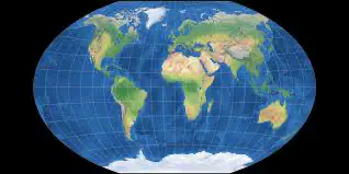
This type of map projection is
Mercator projection
Azimuthal projection
Winkel Tripel projection
Robinson Projection
Goode Homolosine projection
What are the 5 Themes of Geography
Movement, Region, Human Environment Interaction, Location, Place
Movement, Region, Diffusion, Space, Location, Distance, Place
Region, Space, Movement, Location, Human Environment Interaction,
Culture, Place, Movement, Climate, Region, Location, Space
People, Environment, Location, Place, Distribution, Movement, Region

