
 Worksheets
Climate Quiz
Total questions: 71
Worksheet time: 1hrs 12mins

A Sea Breeze occurs during the
night.
day.
night and day.
alien encounter.

A land breeze occurs
during the day.
at night.
during the day and night.
at no time.
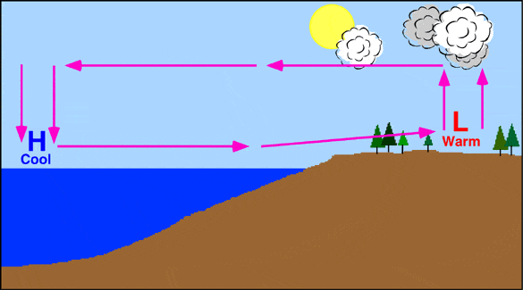

Air moves from _______ pressure to ________ pressure.
high to low
low to high
high to high
low to low
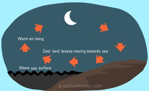

What time of day do you usually find a land breeze?
Morning
Afternoon
Night

Sea and land breezes happen because
the land heats and cools more quickly than the water
the land heats and cools more slowly than the water
air moves more easily over water than land
air moves more easily over land than water
Air moves from areas of ____ pressure to areas of _____ pressure.
H ; H
L ; H
L ; L
H ; L
What heats up and cools down faster?
Land
Water

The arrow above the water is coming down and is blue because
the water is warm so it warms the air and warm air sinks.
the water is cold so it warms the air and cool air sinks.
the water is cold so it cools the air and cool air sinks.
the water is warm so it warms the air and cool air sinks.
The arrow above the land is going up and is red because
the land is warm so it warms the air and warm air rises.
the land is cold so it warms the air and cool air sinks.
the land is cold so it cools the air and cool air sinks.
the land is warm so it warms the air and cool air rises.
The H pressure area involves cold air moving _____________ and is near the _____________.
down ; land
up ; water
down ; water
up ; land
The L pressure area involves warm air moving _____________ and is near the _____________.
down ; land
up ; land
down ; water
up ; water
L pressure areas involve warm, __________ ______________ air moving upward.
less dense
more dense
less cold
more cold
The L pressure area involves warm air moving _____________ and is near the _____________.
up ; land
down ; water
up ; water
down ; land
The H pressure area involves cold air moving _____________ and is near the _____________.
up ; land
down ; water
down ; moon
down ; land
What is a convection current?
Air that moves in an upward direction only resulting from temperature differences.
Air that moves in a downward direction only resulting from temperature differences.
A circulating flow of air or water resulting from temperature differences.
A circulating flow of air or water resulting from temperatures that are exactly the same.

The map shows an eastern portion of North America. Points A and B represent locations on the eastern shoreline. Which factor is primarily responsible for location A having a lower average yearly temperature than location B?
A) nearness to a large body of water
B) elevation
C) latitude
D) prevailing winds

The photograph below shows Mt. Kilimanjaro, a volcano in Africa, located near the equator. Which climate factor is responsible for the snow seen on Mt. Kilimanjaro?
A) high latitude
B) high elevation
C) nearness to a cold ocean current
D) nearness to a high-pressure weather center
Compared to the climate conditions of dry inland locations, the climate conditions of locations influenced by a nearby ocean generally result in
A) hotter summers and colder winters, with a larger annual range of temperatures
B) hotter summers and colder winters, with a smaller annual range of temperatures
C) cooler summers and warmer winters, with a larger annual range of temperatures
D) cooler summers and warmer winters, with a smaller annual range of temperatures
How does the average annual surface temperature compare from latitude to latitude?
As latitude increases, the average annual surface temperature decreases.
As latitude increases, the average annual surface temperature remains the same.
As latitude increases, the average annual surface temperature increases.
Well, it's not this one.
In the northwest, a dryer climate is experienced by communities on which side of the Cascade Mountain Range?
windward
north
leeward
south
choose all the factors that influence regional climates
bodies of water
altitude
mountains
global wind patterns
elevation
On the windward side of a mountain, humid air moves up the mountain's slopes and cools to form clouds that produce precipitation; then the dry air warms as it goes down the leeward side of the mountain. This process describes how climate is affected by _____________
large body of water
Mountain Range
altitude
latitude
What kind of climate would you expect to find in a region located inland away from a large body of water as compared to a region at the same latitude that is near a large body of water?
warm temperatures most of the time
more extreme highs and lows
mild and stable
cold most of the time
In North America, on which side of a mountain range would you expect to find a desert?
windward
doldrums
leeward
horse latitudes

What month has the highest temperature?
June
August
December
January
What month has the highest precipitation?
June
August
December
January
What latitude has the coldest temperatures?
Equator
Tropic of Cancer
Arctic Circle
Tropic of Capricorn
Select the factors that influence climate
Latitude
Proximity to Water
Sunlight
Winds
What is the best explanation for these two statements?
1. Some mountains located near the Earth's Equator have snow-covered peaks.
2. Icecaps exist at the Earth's poles.
High elevation and high latitude have a similar effect on climate.
The higher the elevation, the warmer the climate.
Mountain and polar regions receive more energy from the Sun than other regions.
An increase in snowfall and an increase in temperature have a similar effect on climate.

Which city has the greatest temperature range?
A
B
C
D
The parts of the Earth near the equator receive more sunlight than the north or south poles.
How does this impact the climate at the equator?
It makes the climate warmer.
It makes the climate rainy.
It makes the climate dry.
It makes the climate cooler.


On which side of the mountian would you most likely find humid air and green plants?
A
B

Which location has would have a warmer climate?
A
B
Temperature is affected by
Latitude
Altitude
Distance from large bodies of water
Ocean Currents
All of the above
The main factors affect the precipitation are
prevailing winds
mountain ranges
seasonal winds
all of the above

Which city will have a cooler average temperature
Chapel Hill
Havana
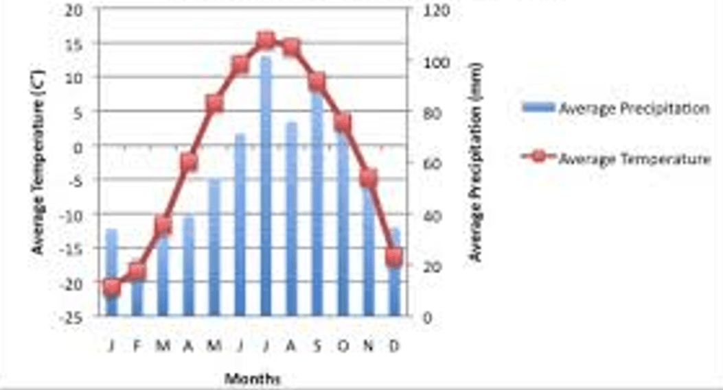

Which month has the coldest temperature?
January
April
September
March

In which month do they get the most rain in this biome?
January
May
August
November
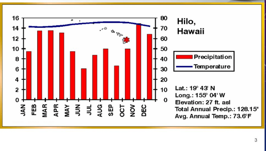
When does the least precipitation occur?
February - March
April - May
June - July
November - December

Which months have the warmest temperatures?
December, January, February
March, April, May
June, July, August
September, October, November

When is there the most precipitation & highest temperatures?
February
July
September
December

What is being shown on the X axis?
Months
Temperature
Precipitation
Years
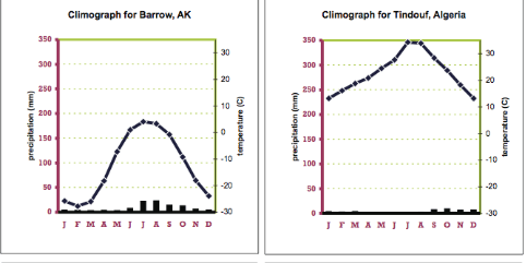
Which of the following is a similarity between these two biomes
low temperatures
high temperatures
low precipitation levels
permanently frozen ground
What is NOT a factor that affects climate?
Ocean Currents
Energy
Elevation/Altitude
Urban Development
What do climographs show?
Temperature and Precipitation
Temperature and Air Pressure
Dew Point and Precipitation
Dew Point and Air Pressure

What can you tell about this climograph?
There was a LOT of change in precipitation throughout the year.
The rain stayed the same throughout the year.
There was very LITTLE rain in the summer.
There was a LOT of rain in the summer.

What can you tell about this climograph?
The precipitation and temperature both INCREASED in the summer months.
The precipitation and temperature both DECREASED in the summer months.
There was very LITTLE precipitation throughout the year.
There was a LOT of precipitation throughout the year.

What can you tell about this climograph?
It is COOLER in the summer because it is near the poles.
It is COOLER in the summer because it is near the ocean.
It is WARMER in the summer because it is near the poles.
It is WARMER in the summer because it is near the ocean.
How much precipitation does this location get in August?
30 mm
200 mm
375 mm
37 mm
What is the temperature in December?
400 degrees Celsius
14 degrees Celsius
2 degrees Celsius
14 degrees Fahrenheit
How would you describe this climate? (Pick 2)
Warm
Cold
Dry
Wet

How would you describe this climate in the summer? (Pick two)
Hot
Cold
Dry
Wet

Which climograph best represents the place you see in the picture?


Why do places near the equator tend to be warmer?
They are closer to the sun.
They receive direct sunlight all year long.
Greenhouse gases are more significant near the equator
More people live near the equator so there is more pollution

Which location has the most total annual (yearly) precipitation?
A
B
C
D

Which location is closer to the equator?
Location A
Location B
The two main types of data associated with climate are
Precipitation and temperature
Wind direction and wind speed
Temperature and pressure
Carbon dioxide and methane levels

Land and sea breezes are created because during the day, when the sun is up, the (a) heats up (b) than the ocean. At night, when the sun is down, the land cools off more (c) than the ocean. This difference in (d) creates the breezes.

