Wayground logo

Free Printable Worksheets

Font size

S
M
L
XL
Worksheets

Geosphere

Total questions: 38

Worksheet time: 19mins
Name
Class
Date
1.

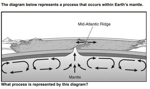
What is the primary mechanism driving the movement of tectonic plates on Earth's surface represented in this image?

a)
A. Ocean currents
b)
B. Gravitational pull from the moon
c)
C. Mantle convection
d)
D. Wind patterns
2.

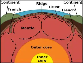
What causes the convection currents in the Earth's mantle?
a)
A. Differences in temperature and density
b)
B. Earth's rotation
c)
C. Magnetic field interactions
d)
D. Solar radiation
3.

Thermal energy in the inner and outer core is heat that is from the original formation of Earth. Thermal energy is transferred from the outer core towards the crust through the mantle. Which BEST describes how energy moves through the mantle?

a)
Thermal energy rises with heated magma from near the core and sinks back down as it cools through convection.
b)
Thermal energy heats up the magma by radiation and passes through the mantle as conduction.
c)
Thermal energy moves by conduction from the outer core, through the mantle, and to the crust by direct contact.
d)
Thermal energy radiates from the outer core, through the mantle, to the crust.
4.

When plate tectonics move, they can form different landforms. Which is LEAST likely to be associated with tectonic plate movement that forms volcanoes?

a)
A. Hot spot
b)
B. Rift valley
c)
C. Subduction zone
d)
D. Transform boundary
5.

What is the primary difference between P-waves and S-waves?

a)
A. P-waves travel only through liquids, while S-waves travel only through solids.
b)
B. P-waves are slower than S-waves and can move through both solids and liquids, while S-waves are faster and only travel through solids.
c)
C. P-waves travel faster than S-waves and can move through both solids and liquids, while S-waves are slower and only travel through solids.
d)
D. P-waves and S-waves travel at the same speed but through different materials.
6.

How does a seismograph help triangulate the location of an earthquake?

a)
A. By measuring the intensity of seismic waves at different depths within the Earth.
b)
B. By detecting changes in magnetic fields caused by seismic activity.
c)
C. By recording the arrival times of P-waves and S-waves at different seismograph stations.
d)
D. By analyzing the chemical composition of rocks near the earthquake epicenter.
7.

Where are most volcanoes located?

a)
A. At divergent boundaries, transform boundaries and hot spots
b)
B. At convergent boundaries, divergent boundaries and hot spots
c)
C. At convergent boundaries, hot spots and transform boundaries
d)
D. At divergent boundaries, convergent boundaries and transform boundaries
8.

Why do many earthquakes and volcanoes occur along the Ring of Fire?

a)
The Ring of Fire increases convection in Earth's core.
b)
The Richter scale is less active around the Ring of Fire.
c)
The Ring of Fire is located along active plate boundaries.
d)
The Atlantic Ocean is surrounded by the Ring of Fire.
9.

At which type of plate boundary would you most likely find a deep-sea trench?
a)
A. Convergent boundary (oceanic-oceanic)
b)
B. Convergent boundary (oceanic-continental)
c)
C. Divergent boundary
d)
D. Transform boundary
10.

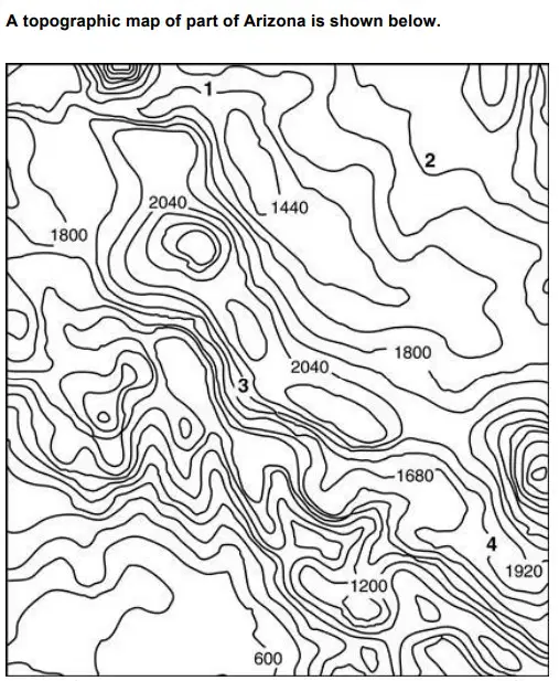
Which of the labeled points below has the steepest slope?

a)
A. 1
b)
B. 2
c)
C. 3
d)
D. 4
11.

Which type of fault is characterized by horizontal movement along the fault plane?

a)
A. Normal fault
b)
B. Reverse fault
c)
C. Strike-slip fault
d)
D. Thrust fault
12.

Which geological process is primarily responsible for the formation of mid-ocean ridges?

a)
A. Seafloor spreading
b)
B. Subduction of oceanic crust
c)
C. Mountain building
d)
D. Earthquakes along fault lines
13.

Which geological feature can form when two continental plates move toward one another at a convergent plate boundary?

a)
a mountain
b)
a new seafloor
c)
an ocean trench
d)
a chain of volcanic islands
14.

Chemical weathering involves:

a)
A. Breaking rocks into smaller pieces without altering their chemical composition.
b)
B. Physically wearing away rock surfaces by abrasion.
c)
C. Changing the chemical composition of rocks through reactions with water, acids, and gases.
d)
D. The physical splitting of rocks through freeze-thaw cycles.
15.
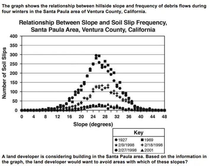
(2.4)
a)
A. 0-5°
b)
B. 12-18°
c)
C. 22-28°
d)
D. 32-38°
16.

Which of the following describes a way in which soil formation affects the geosphere?
a)
A. By reducing the rate of rock weathering
b)
B. By contributing to the formation of new rock layers through sedimentation
c)
C. By decreasing the amount of organic material in the Earth's crust
d)
D. By preventing the formation of mineral deposits
17.

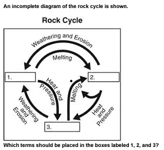
Look at the rock cycle diagram. Which terms should be placed in the boxes labeled 1, 2 and 3?

a)
A. 1 = Metamorphic Rocks, 2 = Sedimentary Rocks, 3= Igneous Rocks
b)
B. 1 = Metamorphic Rocks, 2 = Igneous Rocks, 3 = Sedimentary Rocks
c)
C. 1 = Sedimentary Rocks, 2 = Metamorphic Rocks, 3 = Igneous Rocks
d)
D. 1 = Sedimentary Rocks, 2= Igneous Rocks, 3 = Metamorphic Rocks
18.

Which contributes the most to beach erosion?

a)
A. Animal activity
b)
B. Wave action
c)
C. Precipitation
d)
D. Evaporation
19.

How can shifting tectonic plates create igneous rock?

a)
One plate can rub against another, creating high temperatures that can melt sediment particles into igneous rock.
b)
Two plates can collide, creating a ridge where low temperatures freeze sediment particles into igneous rock.
c)
Two plates can separate, creating a crack through which liquid magma can flow and cool into igneous rock.
d)
One plate can slide under another, creating particles that are compacted and cemented into igneous rock.
20.

Eruption of a large volcano on a tropical island releases ash and gases into the atmosphere. After the eruption, the air temperatures on the island cool temporarily before returning to normal. Which is the most likely reason for the temporary cooling of the island?

a)
A. Water vapor condenses and causes precipitation
b)
B. Large particles of ash blanket the ground surface
c)
C. Fine particles of atmospheric dust block sunlight
d)
D. Carbon dioxide levels increase in the atmosphere
21.

How do hydrothermal vents primarily release substances that contribute to ocean acidification?

a)
A. By emitting large amounts of nitrogen gas
b)
B. By releasing carbon dioxide-rich fluids into the ocean
c)
C. By reducing the salinity of ocean water
d)
D. By decreasing the temperature of the surrounding water
22.

Which of the following is a direct effect of volcanic sulfur dioxide on the atmosphere?

a)
A. Increased formation of acid rain
b)
B. Decreased atmospheric pressure
c)
C. Reduced levels of atmospheric nitrogen
d)
D. Enhanced greenhouse gas effect
23.

How can volcanic activity lead to the creation of new landforms such as mountains and islands?

a)
By depositing ash that compacts into rock
b)
By causing tectonic plates to split apart
c)
By emitting gases that condense into rock
d)
By erupting lava that cools and solidifies into new land
24.
Which would have the most immediate influence on global climate?
a)
volcanic eruptions
b)
deforestation
c)
earthquakes
d)
tsunamis
25.

A volcano near a freshwater lake erupted, causing a drastic decrease in the water's pH and an increase in the water's temperature. What was the most likely impact of the volcanic eruption on the lake's aquatic organisms?

a)
The populations of aquatic organisms increased due to changes in their environment.
b)
The populations of aquatic organisms decreased due to changes in their environment.
c)
The populations of aquatic organisms increased due to improvements in their environment.
d)
The populations of aquatic organisms decreased due to improvements in their environment.
26.
Your data indicates the presence of numerous shallow, high-magnitude earthquakes along a particular fault line. What type of plate boundary is most likely associated with these earthquakes?
a)
A. Divergent boundary
b)
B.Convergent boundary
c)
C. Transform boundary
d)
D. Subduction zone
27.
You notice a cluster of shallow earthquakes along a tectonic plate boundary. What is the most likely cause of these earthquakes?
a)
A. Magma movement beneath a volcano
b)
B. Subduction of an oceanic plate beneath a continental plate
c)
C. The collision of two continental plates
d)
D. Tension acting at a divergent plate boundary
28.
Your mapping reveals a linear arrangement of volcanic islands that become progressively older as you move away from the current volcanic activity. What tectonic feature is likely responsible for this pattern?
a)
A. A divergent plate boundary
b)
B. A hotspot
c)
C. A subduction zone
d)
D. A transform plate boundary
29.
Why did the survivors choose Point X as their strategic location?
a)
A. It is the highest elevation point, offering better defense and visibility.
b)
B. It is closer to water sources.
c)
C. It has a direct path to escape routes.
d)
D. It is surrounded by thick forests
30.
What natural resource did the survivors near Point A utilize?
a)
A. Timber from the forest.
b)
B. Wild fruits and berries.
c)
C. Fish and water from the lake.
d)
D. Shelter in a cave
31.

Once upon a time, there was a sturdy piece of granite nestled deep within a mountain range. For centuries, it endured the slow, relentless forces of nature. Rainwater seeped into its cracks, freezing and thawing, gradually breaking it into smaller fragments. Over time, these fragments were carried away by rivers and streams, settling at the bottom of a tranquil lake.

What process caused the granite to break into smaller fragments?

a)
A. Deposition
b)
B. Weathering and erosion
c)
C. Metamorphism
d)
D. Compaction
32.
Years passed, and layers of sediment piled on top of each other, exerting immense pressure on the granite fragments below. The minerals within these fragments began to fuse together, binding the sediment into solid rock. What process transformed the loose sediments into solid rock?
a)
A. Weathering
b)
B. Erosion
c)
C. Lithification
d)
D. Melting
33.
As tectonic plates shifted, the layers of sedimentary rock were pushed deeper into the Earth's crust. There, under the intense heat and pressure, the rock underwent profound changes. The minerals recrystallized, altering its texture and structure. What type of rock did the sedimentary rock transform into under these conditions?
a)
A. Igneous rock
b)
B. Metamorphic rock
c)
C. Sedimentary rock
d)
D. None of the aboeve
34.
Millions of years later, volcanic activity brought molten magma close to the Earth's surface. As it cooled and solidified, it formed a new type of rock, born from the depths where the granite had once resided. What type of rock did the magma form as it cooled?
a)
A. Igneous rock
b)
B. Metamorphic rock
c)
C. Sedimentary rock
d)
d. None of the above
35.
The Ring of Fire, known for its high volcanic and seismic activity, is mainly associated with which plate?
a)
A. African Plate
b)
B. Pacific Plate
c)
C. Eurasian Plate
d)
D. North American Plate
36.
Which tectonic plate is the largest?
a)
A. Pacific Plate
b)
B. Eurasian Plate
c)
C. African Plate
d)
D. North American Plate
37.
Which plate boundary type is marked by seafloor spreading, where new oceanic crust is formed?
a)
A. Divergent Plate Boundary
b)
B. Convergent Plate Boundary
c)
C. Transform Plate Boundary
d)
D. None of the above
38.
Based on the current plate movements, which of the following regions is most likely to experience significant geological activity such as earthquakes and volcanic eruptions in the near future?
a)
A. The interior of the African Plate
b)
B. The boundary between the Pacific Plate and the North American Plate
c)
C. The middle of the Eurasian Plate
d)
D. The interior of the Antarctic Plate