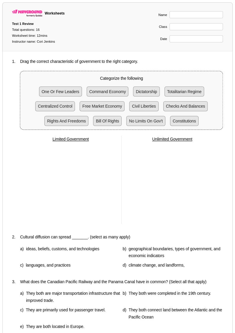
Explore Wayground's free geographical boundaries worksheets and printables that help students master political borders, natural boundaries, and territorial divisions through engaging practice problems with comprehensive answer keys.
Geographical boundaries worksheets available through Wayground (formerly Quizizz) provide comprehensive educational resources that help students understand the complex systems used to define and organize spaces on Earth. These expertly designed materials cover natural boundaries formed by physical features like rivers, mountains, and coastlines, as well as artificial boundaries created through political processes and human decision-making. The worksheets strengthen critical thinking skills as students analyze how boundaries influence cultural identity, economic development, and international relations while examining real-world examples from different continents and regions. Each resource includes detailed answer keys and practice problems that guide students through interpreting maps, identifying boundary types, and understanding the historical context behind territorial divisions. Available as free printables in convenient pdf format, these materials support active learning through engaging activities that connect geographical concepts to current events and global citizenship.
Wayground (formerly Quizizz) supports educators with an extensive collection of teacher-created geographical boundaries worksheets, drawing from millions of high-quality resources developed by experienced social studies professionals worldwide. The platform's advanced search and filtering capabilities enable teachers to quickly locate materials aligned with specific educational standards while offering robust differentiation tools that accommodate diverse learning needs and ability levels. Teachers can easily customize existing worksheets or create new variations, with flexible options for both printable pdf distribution and interactive digital formats that enhance student engagement. These comprehensive features streamline lesson planning by providing ready-to-use materials for skill practice, targeted remediation for struggling learners, and enrichment opportunities for advanced students, ensuring that all learners develop a thorough understanding of how geographical boundaries shape human geography and political landscapes across different scales from local communities to international borders.
FAQs
How do I teach geographical boundaries to students?
Start by distinguishing between natural boundaries, such as rivers, mountain ranges, and coastlines, and artificial boundaries created through political agreements and historical treaties. Use real-world map analysis to show students how these boundary types look in practice, then connect them to consequences like cultural divisions, trade routes, and international disputes. Grounding the lesson in current events or familiar regions helps students see why boundaries matter beyond the map.
What exercises help students practice identifying types of geographical boundaries?
Map interpretation exercises are among the most effective, asking students to classify boundaries as natural or artificial and explain the reasoning behind each. Practice problems that pair a boundary with its historical context, such as the Rio Grande as a political border or the Himalayas as a natural divide, reinforce both identification and analytical thinking. Worksheets that include questions about how boundaries affect cultural identity and economic development push students to apply the concept rather than just recall it.
What common mistakes do students make when learning about geographical boundaries?
A frequent misconception is treating all political borders as permanent or neutral, when in reality many reflect contested histories, colonial decisions, or negotiated compromises. Students also commonly confuse physical features with boundaries, assuming that every mountain range or river automatically serves as a formal border. Worksheets that include counterexamples, such as boundaries that cut across rivers or divide mountain regions, help students unlearn these oversimplifications.
How do geographical boundaries connect to broader social studies concepts?
Geographical boundaries are foundational to understanding political geography, international relations, and cultural identity, making them a natural bridge between map skills and higher-order social studies thinking. When students examine how boundaries have shifted over time, they engage with history, economics, and civics simultaneously. This cross-disciplinary relevance makes boundary topics especially useful for integrated units or project-based learning.
How can I use geographical boundaries worksheets in my classroom?
Geographical boundaries worksheets on Wayground are available as printable PDFs for traditional classroom use and in digital formats for technology-integrated environments, so they fit both in-person and remote instruction. Teachers can also host them as a quiz directly on Wayground, enabling real-time student responses and immediate feedback. Each worksheet includes a complete answer key, which makes them practical for independent practice, homework, or formative assessment without additional prep.
How can I support students with different learning needs when teaching geographical boundaries?
Wayground allows teachers to apply individual accommodations directly to students, including read-aloud support for students who struggle with text-heavy map descriptions, reduced answer choices to lower cognitive load on complex identification tasks, and extended time for assessments. These settings can be assigned per student without notifying the rest of the class, so differentiation stays discreet. Because accommodations are saved and reusable, teachers don't need to reconfigure them for each new worksheet or session.