
 Worksheets
WEDGL
Total questions: 91
Worksheet time: 3hrs 33mins


The difference in the appearance of these two landscapes was caused mainly by the difference in the
climate
amount of uplift
rock type
rock structure
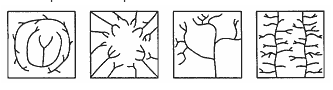
Which factor most likely caused the differences in these stream drainage patterns?
Time
Climate
Human activities
Bedrock structure
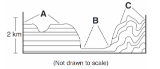
Which list correctly identifies the type of landscapes represented by letters A, B, and C?
A = plain, B = plateau, C = mountain
A = plateau, B = plain, C = mountain
A = mountain, B = plateau, C = plain
A = plain, B = mountain, C = plateau
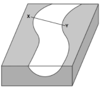
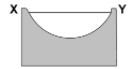
Which cross section best represents the shape of the stream channel at line XY?
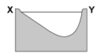
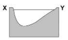
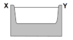
Which rock material was most likely transported to its present location by a glacier?
Unsorted loose gravel found in hills
Residual soil found on a flat plain
Rounded grains found in a sand dune
Rounded sand grains found in a river delta

The pattern of sediment size shown indicates that these sediments were most likely deposited within a
delta
drumlin
morain
landslide
Which climate conditions most likely produce a landscape with rounded hills, large river valleys with many tributaries, and tropical vegetation?
warm and humid
cold and dry
cold and humid
warm and dry
Which agent of erosion most likely moves sediments in a sand dune?
wind
glaciers
wave action
running water
The narrow, sandy, barrier islands in the ocean along the south coast of Long Island were deposited by
wave action
glaciers
wind
streams
Which type of landscape region is found at 44º North latitude and 75º West longitude?
mountains
plains
plateau
lowlands
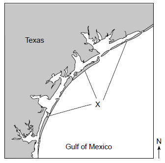
The feature labeled "X" was created by wave action. What is the name of the feature indicated by the letter X?
barrier islands
island arc
delta
morain
What is the name of the largest sediment that can be transported by a stream moving at a velocity of 100 centimeters per second (cm/s)?
sand
silt
pebbles
cobbles

Which land form is produced at location E where the Mississippi River enters the Gulf of Mexico?
delta
drumlin
escarpment
floodplain
At which location would the Mississippi River's discharge most likely be the greatest?
A
B
C
D
Sediments deposited by the river at location B are best described as
sorted and layered
sorted and not layered
unsorted and layered
unsorted and not layered
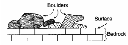
The cross section below represents large boulders made of granite, gneiss, and quartzite that are found lying on limestone bedrock near Oswego, New York.
If no overturning of bedrock has occurred, which statement correctly explains the source of the boulders?
The limestone was changed by contact metamorphism caused by a lava flow.
The limestone bedrock formed under conditions of high heat and pressure.
Older igneous and metamorphic bedrock that once covered the limestone eroded away, forming the boulders.
The boulders were transported and deposited on the limestone bedrock by a glacier.

The diagrams below represent four different examples of one process that transports sediments.
Which process is shown in these diagrams?
chemical weathering
wind action
mass movement
rock abrasion
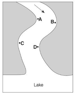
The greatest stream velocities are found closest to points
A and B
B and C
C and D
D and A
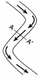
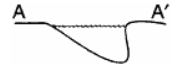
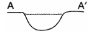
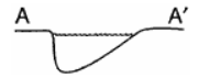
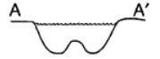
Which stream profile best represents the cross section from A to A' ?
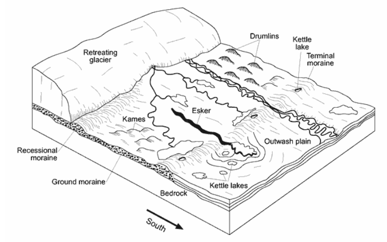
The shape of elongated hills labeled drumlins is most useful in determining the
direction of glacial movement
age of the glacier
thickness of the glacial ice
rate of glacial movement

The moraine deposits left when this glacier melts will generally be
sorted by size and layered
sorted by size and unlayered
unsorted by size and layered
unsorted by size and unlayered
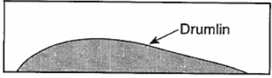
The diagram below represents a side view of a hill (drumlin) that was deposited by a glacier on the Atlantic coast.
This hill is most likely composed of
cemented sediments
unsorted sediments
vertically layered sediments
horizontally layered sediments
What is the minimum water velocity needed in a stream to maintain the transportation of the smallest boulder?
100 cm/sec
200 cm/sec
300 cm/sec
500 cm/sec

The geologic feature shown in the photograph was primarily deposited by which agent of erosion?
glaciers
wind
wave action
running water

This glacial landscape feature is best identified as
a kettle lake
an outwash plain
a finger lake
a moraine
The largest particles that a stream deposits as it enters a pond are 8 centimeters in diameter. The minimum velocity of the stream is approximately
100 cm/sec
200 cm/sec
300 cm/sec
400 cm/sec
Which cross section best represents the valley shape where a rapidly flowing stream is cutting into the bedrock in a mountainous area?
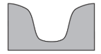
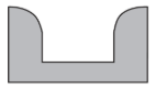
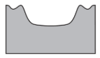
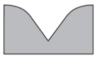

The model shown below illustrates stream erosion between locations A and B in the stream.
Placing a second block under location A will cause the stream's velocity to
decrease and the rate of erosion to decrease
decrease and the rate of erosion to increase
increase and the rate of erosion to decrease
increase and the rate of erosion to increase

The map below shows coastal features of a portion of Long Island, New York. Point A represents a location on a landscape feature that resulted from wave action and longshore currents.
On which landscape feature is point A located?
moraine
moraine
barrier island
floodplain

Base your answer on the contour map below, which shows a hill formed by glacial deposition near Rochester, New York. Letters A through E are reference points. Elevations are in feet.
This glacial deposit is best identified as
a V-shaped valley
a sand dune
a drumlin
an outwash plain
Base your answer on the contour map below, which shows a hill formed by glacial deposition near Rochester, New York. Letters A through E are reference points. Elevations are in feet.
According to this hill of unsorted sediments, what direction was the glacier advancing?
South
North
East
West
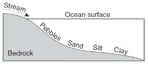
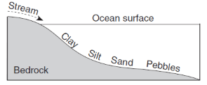
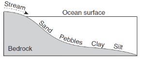
Which profile best shows the general depositional pattern that occurs when water from a stream enters the ocean?

This valley was carved by...
a river
a road
a glacier
an earthquake
What type of weathering does not change the composition of a rock?
chemical weathering
dissolution
mechanical weathering
oxidation
What type of climate is required for strong chemical weathering?
Hot and wet
Hot and dry
Cold and wet
Cold and dry
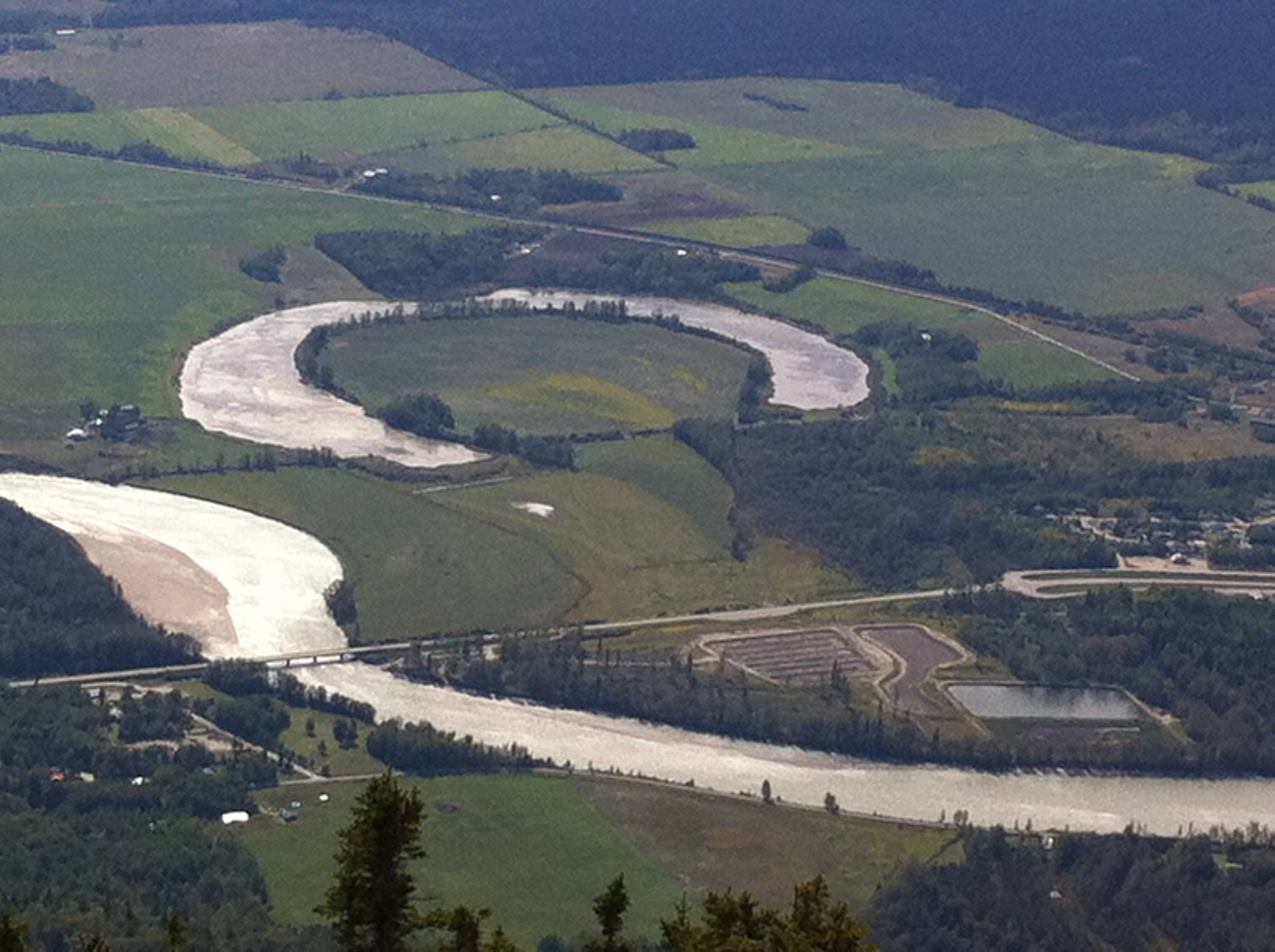
What feature is pictured?
oxbow lake
braided river
U-shaped valley
landslide
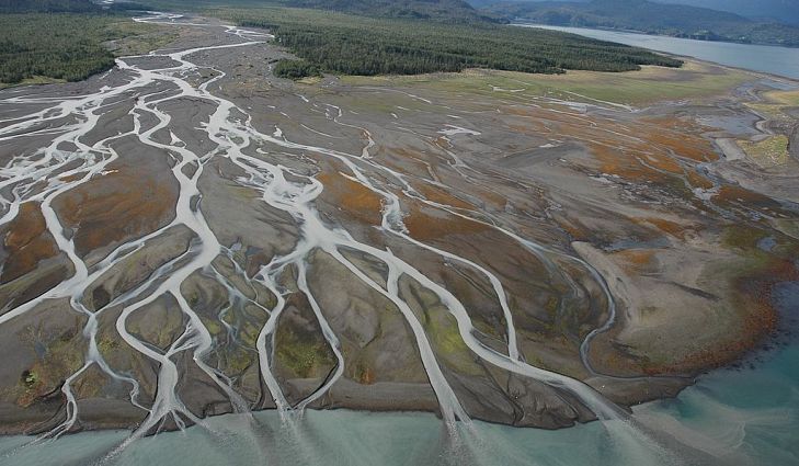
When a river meets a large body of water...
it speeds up, picking up more material
it continues at the same speed
it slows down, depositing material
it makes a whirlpool
The top surface of water in the ground is called the...
zone of aeration
water table
zone of saturation
impermeable layer
If a rock has high permeability, it will...
not allow any water to flow through
allow a small amount of water through
allow water to flow through freely
Porosity is...
how easily water flows through a material
the resistance to flow
how much empty space there is within a material
a form of chemical weathering
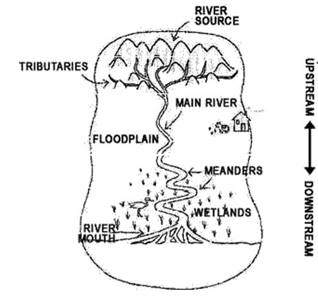
What is a watershed?
a shed with water
rivers and streams
land area that drains tributaries and rivers into it
wetlands and marshes
What are the smaller streams that flow into larger rivers called?
oceans
bays
creeks
tributaries
What is the name of the part of land that ground water is stored?
zone of aeration
water table
zone of saturation
zone of bedrock

Why will this parking lot cause problems with flooding?
it has too many spaces
it has an impermeable surface
it has a permeable serface
there are no problems with flooding
When gravity acts on loose rocks and soil and pulls them down toward Earth in a landslide/mudslide. This action is called?
Mass movement
Matter movement
Deposition
Displacement
Which event is an example of chemical weathering?
rocks falling off the face of a steep cliff
feldspar in granite being crushed into clay-sized particles
water freezing in cracks in a roadside outcrop
acid rain reacting with limestone bedrock
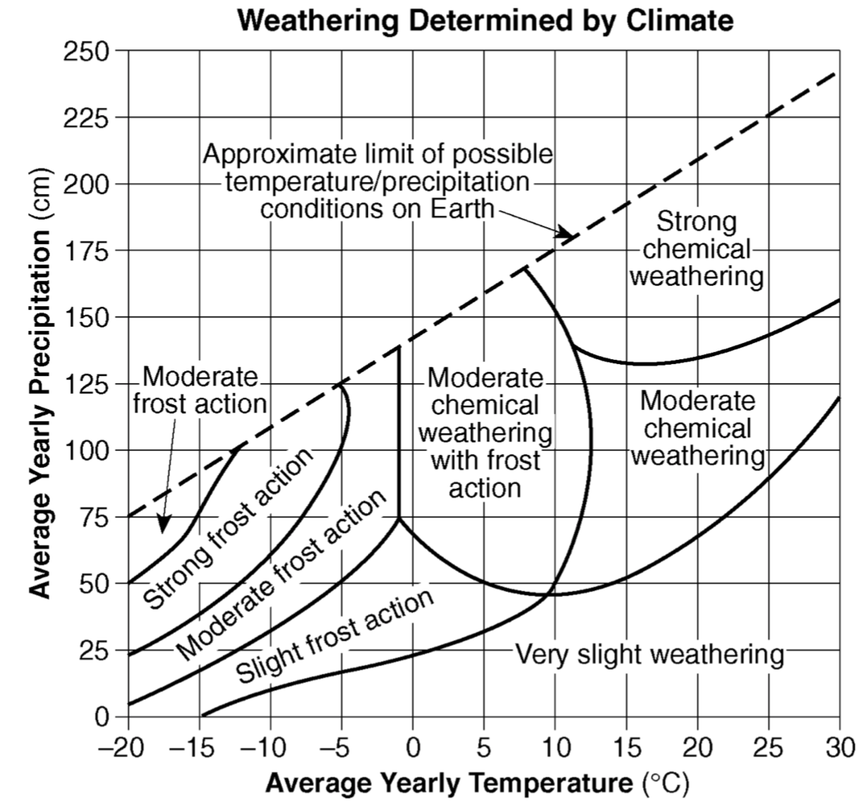
The amount of chemical weathering will increase if
air temperature decreases and precipitation decreases
air temperature increases and precipitation decreases
air temperature decreases and precipitation increases
air temperature increases and precipitation increases

The cross section below shows sedimentary bedrock layers A, B, C, and D exposed at Earth’s surface. Which layer appears to be the least resistant to weathering?
A
B
C
D
Humus, which is formed by the decay of plant and animal matter, is important for the formation of most
soils
minerals
delicious dip for pita chips
surface bedrock
Which factor has the most influence on the development of soil?
climate
longitude
amount of eroded sediment
slope of the landscape
A landscape region that has broad, U-shaped valleys with polished and grooved bedrock was most likely formed by
running water
glaciers
wind
wave action
The largest sediment particles that can be transported by a stream traveling at a velocity of 200 centimeters per second are
silt
cobbles
pebbles
sand
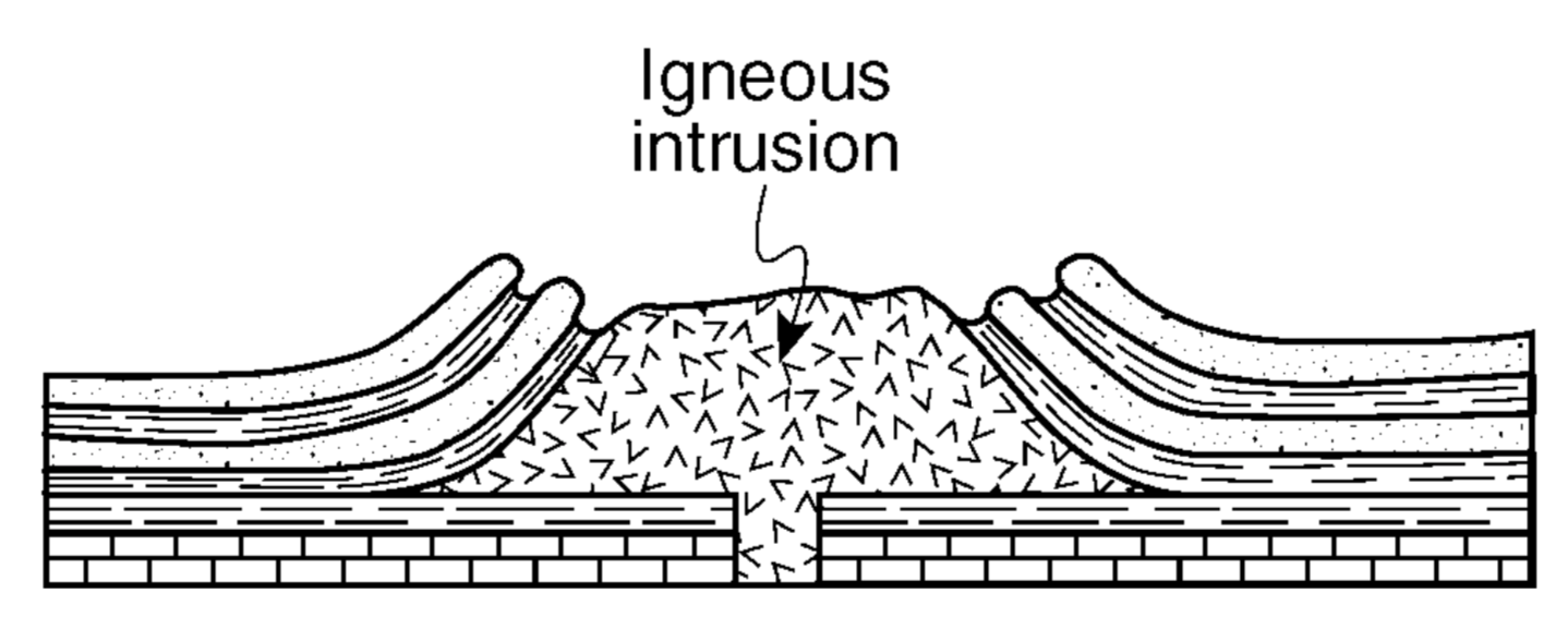
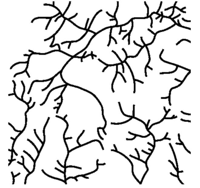
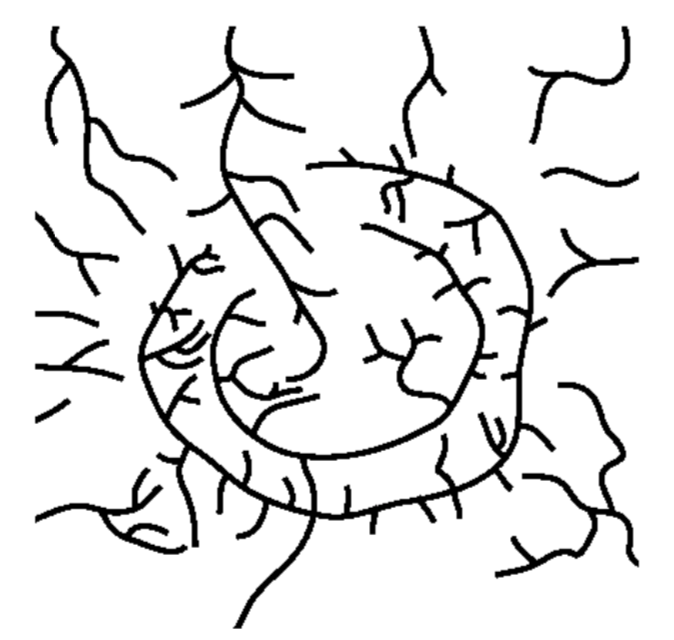
The cross section above shows the rock structure of a deeply eroded, domed mountain region. Which map shows the stream drainage pattern that will most likely develop as the bedrock is weathered and eroded from this igneous dome?
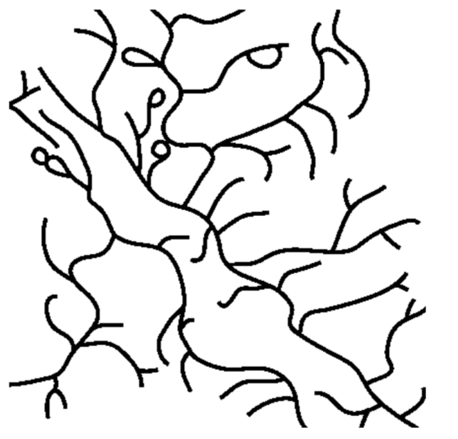
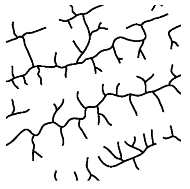

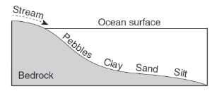
The accompanying cross section illustrates the general sorting of sediment by a river as it flows from a mountain to a plain. Which factor most likely caused the sediment to be sorted in the pattern shown?
velocity of the river water
hardness of surface bedrock
mineral composition of the sediment
temperature of the water
A sedimentary particle is dropped into a cylinder of water. The particle will take the longest time to settle if the particle has
low density, small size, and spherical shape
low density, small size, and flattened shape
high density, large size, and spherical shape
high density, large size, and flattened shape
A sediment particle transported by a stream over a long period of time will most likely show
a decrease in mass and number of angular edges
a decrease in density and size
an increase in weight and hardness
an increase in volume and number of cleavage planes
Which diagram represents a side view of a sand dune most commonly formed because of the prevailing wind direction shown?


The block diagram above represents a rapid downslope flow of saturated soil and rock layers. What are two likely causes of this rapid downslope flow?
groundwater and abrasion
groundwater and gravity
prevailing wind and gravity
prevailing wind and abrasion
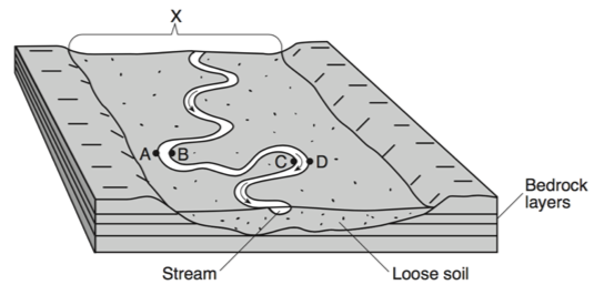
The landscape feature labeled X is best described as
a flood plain
a sand bar
a delta
an escarpment

When two meanders meet, and the river is redirected, the resulting formation is called
an oxbow lake
a drumlin
a delta
an outwash plain
What is the minimum water velocity necessary to maintain movement of 0.1-centimeter-diameter particles in a stream?
0.02 cm/s
5.0 cm/s
0.5 cm/s
20.0 cm/s
A stream flowing at a velocity of 75 centimeters per second can transport
clay, only
pebbles, only
pebbles, sand, silt, and clay, only
boulders, cobbles, pebbles, sand, silt, and clay
After a heavy rainstorm, vegetation on a hillslope was completely removed. How will this removal of vegetation affect the relative amounts of infiltration and runoff that occur during the next heavy rainstorm?
Infiltration and runoff will both be less.
Infiltration and runoff will both be greater.
Infiltration will be less and runoff will be greater.
Infiltration will be greater and runoff will be less.

The block diagram represents a landscape where caverns and sinkholes have gradually developed over a long period of time. Which type of weathering was primarily responsible for the development of these caves?
physical weathering of sandstone
physical weathering of limestone
chemical weathering of standstone
chemical weathering of limestone

The Genesee River flows across both the Allegheny Plateau and the Erie-Ontario Lowlands in New York State. This river flows
northward, in the same general direction as the Hudson River
northward, in the same general direction as the Niagara River
southward, in the same general direction as the Hudson River
southward, in the same general direction as the Niagara River
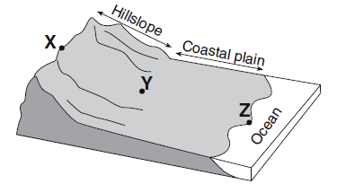
Compared to the stream velocity between point X and point Y, the stream velocity between point Y and point Z is most likely
greater, since the slope of the land decreases
greater, since the slope of the land increases
less, since the slope of the land decreases
less, since the slope of the land increases

Erosion is most likely greatest at locations
A and B
B and C
C and D
D and A
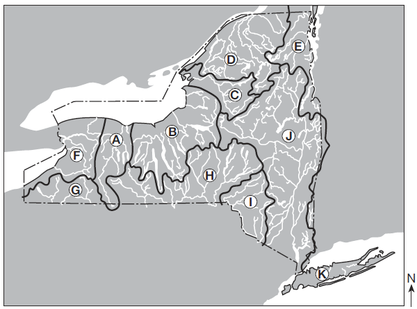
Over which two landscape regions do the streams in watershed D flow?
Tug Hill Plateau and the Catskills
Tug Hill Plateau and Erie-Ontario Lowlands
Adirondack Mountains and Champlain Lowlands
Adirondack Mountains and St. Lawrence Lowlands

The Genesee River in watershed A generally flows in which direction?
north
south
east
west
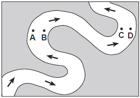
Which two locations have the greatest stream velocities?
A and B
B and C
C and D
D and A

The three areas separated by highland divides are called
Tributaries
meanders
watersheds
floodplains
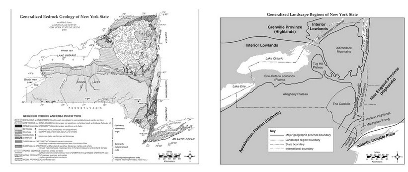
Which two cities are located in the Interior Lowlands?
Elmira and Binghamton
Riverhead and New York City
Massena and Old Forge
Buffalo and Watertown
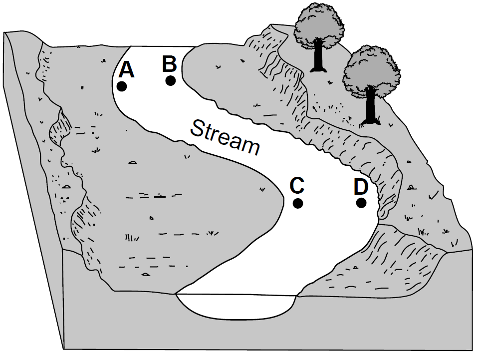
At which two locations would the stream most likely be the deepest?
A and B
B and C
C and D
D and A

The greatest stream velocities are found closest to points
A and B
B and C
C and D
D and A

The streambank on the outside of this meander is steeper than the streambank on the inside of this meander because the water on the outside of this meander is moving
faster, causing erosion
slower, causing erosion
faster, causing deposition
slower, causing deposition

At which point does the greatest stream erosion occur?
A
B
C
D

The photograph shows scratched and grooved
bedrock with boulders on its surface. The scratches and grooves were most likely created when
alternating thawing and freezing of water cracked the bedrock
flooding from a nearby lake covered the bedrock
a glacier dragged rocks over the bedrock
rocks from a landslide slid along the bedrock

Base your answer to the following question on the map. Arrows on the map show the location and orientation of glacial striations on the surface bedrock. Dark shading shows the location of large moraines (glacial deposits). How were the striations made?
Frost action cracked the bedrock during the ice age.
Rocks at the bottom of the glaciers were dragged over the bedrock.
Particles carried by winds scratched the bedrock during the ice age.
Particles carried by glacial meltwater eroded the bedrock.

Base your answer to the following question on the diagram which represents a profile of a mountain glacier in the northern United States. Over a period of years, this glacier gains more snow mass than it loses. What will be the most likely result of this gain?
The glacier will decrease in size, and the ice front will retreat.
The glacier will decrease in size, and the ice front will advance.
The glacier will increase in size, and the ice front will retreat.
The glacier will increase in size, and the ice front will advance.

The diagram shows the edge of a continental glacier that is receding. R indicates elongated hills. The ridge of sediments from X to Y represents a landscape feature. The elongated hills labeled R are most useful in determining the
age of the glacier
direction the glacier has moved
thickness of the glacier
rate at which the glacier is melting
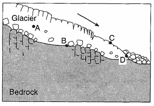
The cross section below represents the transport of sediments by a glacier. At which location is deposition most likely the dominant process?
A
B
C
D
Unsorted, angular, rough-surfaced cobbles and boulders are found at the base of a cliff. What most likely transported these cobbles and boulders?
running water
wind
gravity
ocean currents

Base your answer on the diagrams below. Diagrams A, B, and C represent three different river valleys. Most sediments found on the floodplain shown in diagram A are likely to be
angular and weathered from underlying bedrock
angular and weathered from bedrock upstream
rounded and weathered from bedrock upstream
rounded and weathered from underlying bedrock

Which landscape feature would produce this stream drainage pattern?
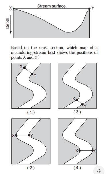
Based on the cross section, which map of a meandering stream best shows the positions of points X and Y?
Which land form is NOT correctly matched with the agent of erosion?
Delta - streams
Sand bar - wind
Moraine - glaciers
Barrier island - waves
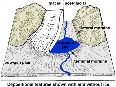
How does the sediment compare at the moraines and the outwash plain?
The moraine and outwash plain are both sorted
The moraine is sorted and the outwash plain is unsorted
The moraine is unsorted and the outwash plain is sorted
The moraine and outwash plain are both unsorted

