Worksheets
Alfred Wegener, Tectonic Plates and Topography
Total questions: 110
Worksheet time: 2hrs 50mins

Describe the most likely relationship between these mountains and nearby tectonic plates.
The mountains are probably formed by earthquakes
The mountains are probably formed by the movement of glaciers
The mountains are probably located near the edge of 2 tectonic plates.
The mountains are probably formed by running water.

Most earthquakes tend to occur at which location?
The central regions of very large continents
Groups of islands farthest from any continents
The boundaries between continents and oceans
The steep slopes of the very oldest mountains
Huge pieces of lithosphere that slowly move on the asthenosphere and consist of the crust and the rigid, uppermost part of the mantle
tectonic plates
North American Plate
Eurasian Plate
African Plate
the place where two different plates have contact.
Pacific Plate
Mountains
Earthquakes
Plate Boundaries
Occurs when two tectonic plates move toward each other and collide
convergent boundary
subduction
volcanic eruptions
divergent boundary
Events in which molten rock spews out from the mantle to the surface of Earth as ash, lava and gases; major geological events that occur when a dense plate subducts below a less dense plate
Mountain Building
Convergent boundary
Divergent boundary
Volcanic eruptions
Major geological event that occurs when continental plates of equal density converge, resulting in mountain chains
Mountain Building
Subduction
Volcanic eruptions
Divergent Boundary
Occurs when two tectonic plates move away from each other.
Divergent Boundary
Convergent Boundary
Volcanic eruptions
Mountain building
Ridges formed from new crustal material at diverging oceanic plate boundaries
Ocean Basin
earthquakes
spreading ridges
transform boundary
Occurs when two tectonic plates slide past each other
Transform Boundary
Ocean Basin
Divergent Boundary
Spreading ridges

Tectonic plates float on top of the ________
Crust
Mantle
Inner Core
Outer Core


What is the thinnest and outer most layer of the Earth, that we live on?
Outer Core
Crust
Mantle
Inner core
Which layer of the Earth is the thickest and is made of molten rock?
Outer Core
Inner Core
Crust
Mantle


What are Tectonic plates?
Large moving pieces on Earth's surface that are made of rock.
where two plates divide
The inner core of the earth
where magma rises up and solidifies
What is continental drift?
Made of igneous rock
Where two plates collide
Theory that all of earths continents were once joined together in a singe, huge land mass and then started drifting away from each other.
The process by which new oceanic crust forms when when magma rises up.
What is pangaea?
Huge supercontinent that existed millions of years ago,
Where two plates slide
Where two plates divide
Where two plates collide
What are divergent Plate Boundaries?
Where two plates divide
Where two plates collide
Where two plates slide
What are Convergent Plate Boundaries?
Where two plates divide
Where two plates collide
Where two plates slide
What are Transform Plate Boundaries?
Where two plates divide
Where two plates collide
Where two plates slide
What is seafloor spreading?
Large pieces of lithosphere that move.
Layer made up of the crust and uppermost mantle
The super continent that existed millions of years ago
Process by which new oceanic crust forms when magma rises up and solidifies at the mid-ocean ridge.
How do tectonic plates move?
Wind
Convection currents
Water
What are tectonic plates?
Pieces of the Earth's crust
A type of boundary
Pieces of the Earth's inner and outer core
Pieces of the mantle that are solid
What is the name of the process where hot air/liquids rise and cool air/liquids drop?
natural currents
convergent currents
conduction currents
convection currents
Which of the following phenomena is not produced due to the Earth's magnetic field?
protection against cosmic radiation
compasses pointing north
gravity
aurora borealis
What are the 3 types of tectonic plate boundaries?
convergent, divergent, mid ocean ridge
divergent, convergent, allegiant
convergent, divergent, oblique
divergent, convergent, transform
Which way do plates in a divergent boundary move?
toward each other
parallel to each other
away from each other
perpendicular to each other
Which way do plates in a transform boundary move?
toward each other
parallel to each other
away from each other
perpendicular to each other
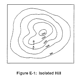


If sea level always equals (0), and the contour interval is 10 feet how tall is this mountain?
30 ft
40 ft
50 ft
60 ft

Match the topographic map to its profile.


Match the topographic map to its profile picture.


What is the contour interval?
1 ft
5 ft
10 ft
60 ft

Which side of this island is the steepest?
South
North
East
West

What do each of the contour lines on a topographic map represent?
Elevation
Elevation Change
Boundaries
Rivers & Streams

What is the elevation change from A to B?
600 feet
500 feet
547 feet
447 feet
How can water change the appearance of a topographic map?
Water doesn’t have an impact
The flow of water are represented by the lines on a topographic map
Water can fill up in all the circles on the map
Water can weather and erode away soil and rock
What is topography?
The study of the land's shape.
The study of elevation changes.
The study of mountains.
The study of altitude.
Why are topographic maps useful?
They are able to show elevation on flat pieces of paper.
They are not.
They show you how to get home.
They show local trails.

What is the elevation at the top of this mountain?
14,000
14,110
15,000
14,119

Which side of the mountain is LESS steep?
North
East
West

What is the elevation at Position A?
1600
1500
20
240

What is the elevation at position B?
1500
1600
20
240

What is the contour interval of this map?
1500
1600
20
240

What is the elevation change between Position A and B?
1500
1600
100
240

What is the elevation change between Position A and C?
1500
1640
240
100

Which direction is the steepest slope facing on Enchanted Rock?
Northwest
Northeast
Southwest
Southeast
What is a contour line?
a line joining points of equal elevation above a given level
A contour line accentuated by a heavier line weight to distinguish it from intermediate contour lines.
The height to which something is elevated above a point of reference, especially mean sea level
the difference in altitude represented by the space between two contour lines on a map
What is elevation?
a line joining points of equal elevation above a given level
A contour line accentuated by a heavier line weight to distinguish it from intermediate contour lines.
the difference in altitude represented by the space between two contour lines on a map
The height to which something is elevated above a point of reference, especially mean sea level


In the picture, the lines you see are called elevation lines. a ‘line of equal elevation’ is also called a ....
Contour line
Relief

The distance between contour lines is called...
Contour interval
Contour line
Colors
Mountains

If the lines are close together on the map, it means that the rise/drop is ________________
Steep
Gradual
Whichever ‘dot’ or location is higher on a map, is the _________
Steepest
Gradual, or less steep

Determine the interval by counting from the smallest to the biggest number. Look for a pattern, or the number that each line ‘jumps’ by between the numbers. Each line should have a number it represents.
The interval is 10 because each line counts up by 10.
The interval is 60 because that is the biggest number.
The interval is M
How confident do you feel about what we just covered. 10 is the most confident, 0 is the least. 5 is somewhere in the middle.
10
0
5

Which one is the steepest?
2
1
4
What can you find on a topographic map
height of a mountain & the gradient/slope
people
animals