
 Worksheets
Unit 10 Meteorology Study Game
Total questions: 65
Worksheet time: 16hrs 15mins
What do we call the temperature at which air becomes saturated (100% RH)?
Most clouds form in the atmosphere when moist
air
rises, expands and cools to the dewpoint
rises, expands, and warms to the dewpoint
sinks, compresses and cools to the dewpoint
sinks, compresses and warms to the dew point
Which cross section correctly represents a cold front and the air-mass movements associated with this front?


What is the relative humidity if the dry bulb temperature is 160C and the wet bulb temperature is 100C?
45%
33%
14%
4%

Clouds most likely form as a result of
moist rising air, compressing and warming
moist rising air, expanding and cooling
dry rising air, compressing and warming
dry rising, expanding and cooling
Which graph best shows the general relationship between altitude and air pressure?


Which list correctly matches each instrument with the weather variable it measures
wind vane—wind speed
thermometer—temperature
precipitation gauge—relative humidity
wind vane—wind direction
thermometer—dewpoint
psychrometer—air pressure
barometer—relative humidity
anemometer—cloud cover
precipitation gauge—probability of precipitation
barometer—air pressure
anemometer—wind speed
psychrometer—relative humidity
Which weather change is most likely indicated by rapid falling air pressure
humidity is decreasing
temperature is decreasing
skies are clearing
a storm is approaching

Base your answer on the weather map below, which shows the locations of a high-pressure center (H) and a low-pressure center (L) over a portion of North America. The isolines indicate surface air pressures.
The arrows on which map show the most likely path in which these two pressure centers will move over the next few days?


Which map best represents the surface wind pattern associated with high-pressure and low-pressure systems in the Northern Hemisphere?


An air mass entering Alaska from the northern Pacific Ocean would most likely be labeled on a weather map as
cP
cT
mP
mT
Jet stream winds over the United States generally move from
east to west
west to east
north to south
south to north

Base your answer on on the station models below, which show various weather conditions recorded at the same time on the same day at four different cities.
Which city had the lowest relative humidity?
Chicago
Detroit
Buffalo
Utica
What is the dewpoint temperature when the relative humidity is 30% and the air temperature is 20°C?
-28oC
2oC
6oC
9oC

Base your answer on the map below, which shows sea-level air pressure, in millibars, for a portion of the eastern coast of North America. Points A, B, C, and D are sea-level locations on Earth's surface.
Which location most likely recorded the highest wind speed?
A
B
C
D
Which list shows atmospheric layers in the correct order upward from the Earth's surface?
thermosphere, mesosphere, stratosphere, troposphere
troposphere, stratosphere, mesosphere, thermosphere
stratosphere, mesosphere, troposphere, thermosphere
thermosphere, troposphere, mesosphere, stratosphere
Which weather-station model shows an air pressure of 993.4 millibars?


Base your answer on the weather map below. The map shows a low-pressure system and some atmospheric conditions at weather stations A, B, and C.
Which cross section best represents the air masses, air movement, clouds, and precipitation occurring behind and ahead of the warm front located between stations A and B?


Which cross section best represents a cold front?


The station model below shows some weather conditions at a location on Earth's surface.
Which present weather symbol represents the most likely type of precipitation occurring at this location?


Does a CYCLONE have low or high pressure?
Low
High
The eye of a cyclone is
Cloudy and highly stormy
full of strong winds
calm and cloudless
site with high atmospheric pressure

Which of the following plays an important role in the early-warning systems for cyclones?
Helicopters
Submarines
Satellites
Stars
What is another name for cyclone in japan ?
Tornadoes
Typhoon
Hurricane
Thunderstorm
Tropical cyclones are called different names in different places. Tropical cyclones found in the USA are called...
Typhoon
Hurricane
Cyclone
Willy-willy
How high can winds reach in a tornado?
10 miles per hour
80 miles per hour
300 miles per hour
1,000 miles per hour
Would CYCLONES be more likely to occur with warm or cold weather?
Warm
Cold

If you had to evacuate during a hurricane, what does that mean?
Leave an area
Fight off a hurricane
Stay in your house
Buy supplies before the hurricane hits
What happens immediately after a hurricane makes landfall?
It gets stronger
It gets weaker
Its winds pick up speed
It starts hailing
When is hurricane season
Winter
Summer
Fall
Spring
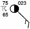
What is the dewpoint for the following station model?
10 ºF
23 ºF
65 ºF
75 ºF
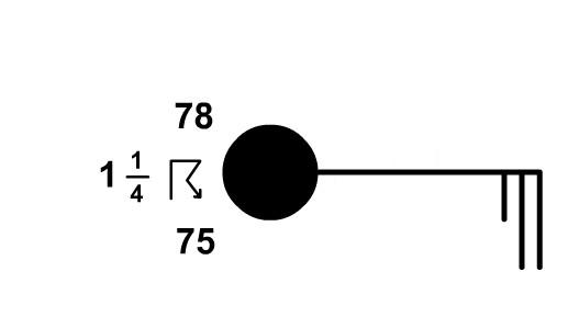
What is the present weather for the following station model?
rain
thunderstorms
drizzle
fog
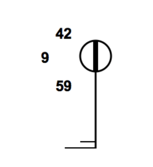
What is the visibility for the following station model?
1/2 mi
9 mi
42 mi
59 mi
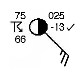
What is the wind speed for the following station model?
10 knots
15 knots
20 knots
25 knots
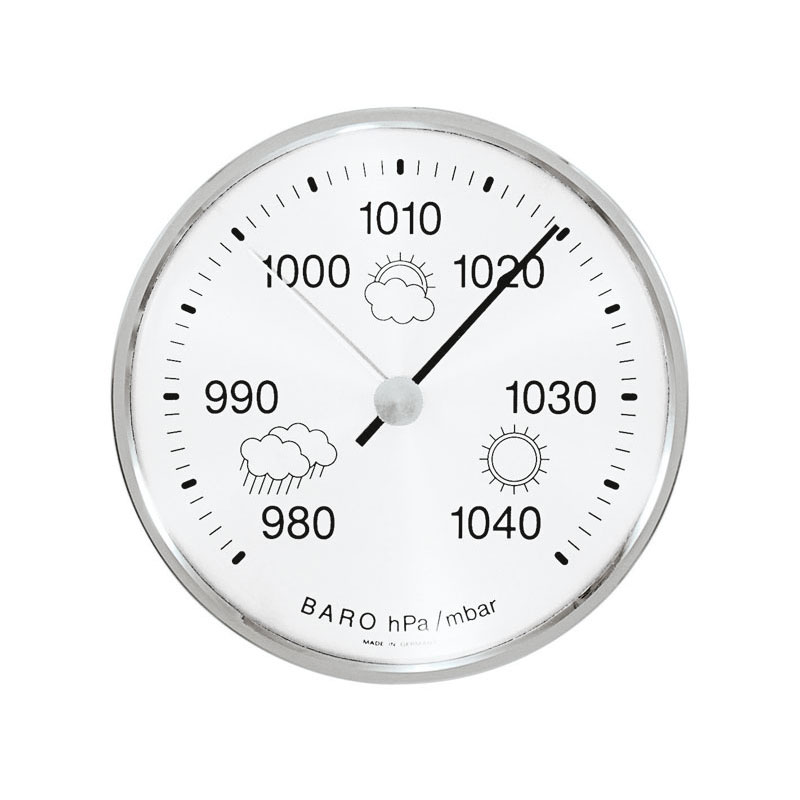
What is the station model code for a barometric pressure of 1019.5 mb?
101
195
019
119
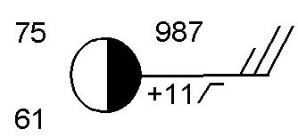
What is the barometric pressure for the following station model?
987 mb
998.7 mb
1098.7 mb
1098 mb
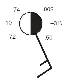
What is the barometric trend for the following station model?
steady 31 mb drop
steady 31 mb rise
steady 3.1 mb drop
steady 3.1 mb rise
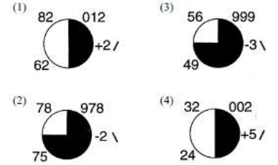
Which weather station shows the highest relative humidity?
1
2
3
4
Will lake effect snow likely develop if the lake is frozen?
no
yes

Erie, Pennsylvania, experiences lake-effect snow in the fall when cold winds from the northwest move across warmer lake water. The air absorbs water vapor from the lake and then deposits it as snow to the east and southeast of the lake. During some winters, the surface of Lake Erie freezes solid. Which statement describes how this event would most likely change lake-effect snow in Erie, Pennsylvania?
Evaporation from the lake would essentially stop, causing less water to be in the surrounding air, which would result in a decrease in the amount of snowfall in Erie.
The weather in Erie would include excessive snow, wind, and freezing temperatures because the lake would be unable to absorb energy from the air.
Winds blowing from the lake and into Erie would stop because the lake cannot lose heat when frozen.
Condensation would increase, producing an increase in the amount of snowfall in Erie because the lake would remain at a constant temperature when frozen.

What part of the water cycle does this picture show?
condensation
precipitation
evaporation
transpiration

When water changes from a liquid to a gas in plants it is called...
condensation.
evaporation.
sublimation.
transpiration.

The movement of water downwards, seeping from the surface into soil, is called _________________
surface run off
infiltration
percolation
interception
The rapid flow of water on land is called _______________
storage
surface run off
throughflow
infiltration

Warm Air is LESS DENSE then Cold Air. So Warm Air creates....
High Pressure
Low Pressure
No Air Pressure
Convert 1016.0 mb to in of Hg.... use ESRT pg 13
30.70
30.00
29.20
28.50
Convert 29.50 in of Hg to mb.... using ESRT pg 13
999.0
1020.0
976.0
1040.0

Which atmospheric conditions describe the air mass that is influencing weather conditions at location C? (ESRT pg 13)
coo and dry
cool and moist
warm and dry
warm and moist
At what approximate altitude in the atmosphere can stratospheric ozone be found? (ESRT pg 14)
10 km
30 km
70 km
100 km
Which map shoes normal paths followed by low-pressure storm centers as they pass across the United States? (ESRT pg 14)


What is the approximate gradient from point A to point B on the map? (ESRT pg 1)
25 feet per mile
50 feet per mile
25 feet per mile
100 feet per mile
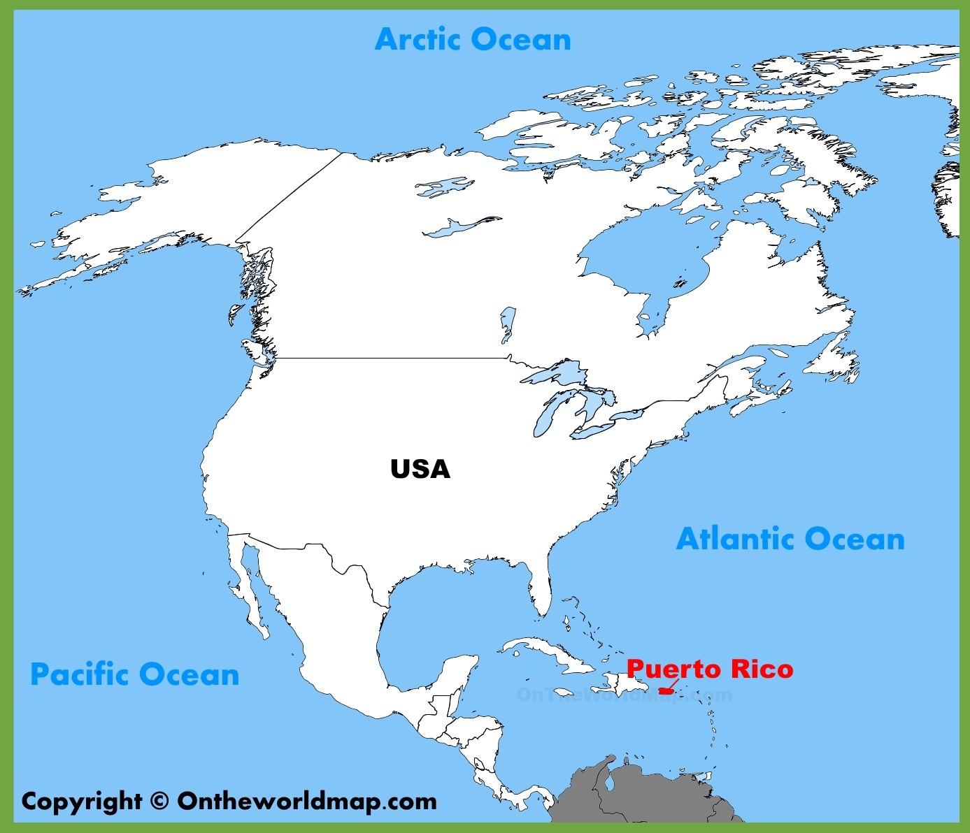
What type of air mass is found over PUERTO RICO?
Maritime Polar
Maritime Tropical
Continental Polar
Continental Tropical
Which type of air mass is COLD and HUMID?
Maritime Polar
Maritime Tropical
Continental Polar
Continental Tropical
If you're outside with no shelter, where is the safest place to be during a tornado?
Under a bridge or overpass.
Hug a tree.
Laying flat in a ditch while covering your head.
Find a vehicle and get in it. Stay low and cover your head.
If you don't have a basement, which of the following choices is the safest shelter during a tornado?
An interior room (closet, hallway, bathroom, etc.) on the lowest floor of your house away from windows.
If one is available, in an outside garage or shed.
The North wall of the house is always the safest.
If you have a fireplace try to crawl into it. Use it as a shelter.
A violently rotating column of air in a low-pressure system that comes contact with the ground and extends from the base of a thunderstorm.
Funnel Cloud
Tornado
Condensation Funnel
Thunderstorm
A scale of wind damage intensity in which wind speeds are inferred from an analysis of wind damage.
Saffir-Simpson scale
Fujita scale
Wind speed scale
Damage indicator scale

