
 Worksheets
8.9 A-C Science Review
Total questions: 72
Worksheet time: 2hrs 24mins
Scientists recently discovered that rocks collected from the Franklin Mountains in West Tests and rocks collected from mountains in eastern Antarctica were exactly the same age. Further research showed that the rocks were chemically and geologically the same and came from the same magma source. This discovery provides evidence of--
coastal erosion
plate tectonics
ocean currents
glacial melting
Which statement best describes the geologic process that is most likely responsible for the formation of mountains?
They are along a transform plate boundary that is no longer active, so erosion is creating deep valleys.
They are along a transform plate boundary in which plates are currently moving side by side, causing earthquakes and faults
They are along a plate boundary in which plates are currently converging, causing uplift and steep slopes.
They are along a plate boundary in which plates diverged in the distance past, allowing new rock to build up.
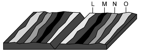
A mid-ocean RIDGE is located at the boundary of two tectonic plates. Which diagram correctly models the relative plate motion on each side of a mid ocean ridge?


Rift valleys can from when fractures in Earth's crust widen. The valley walls slowly move at a rate of only a few millimeters a year. Which of these best describes the type of tectonic activity that forms rift valleys?
Rift valleys from where a continental plate moves under an oceanic plate
Rift valleys form where a plate slides horizontally past another plate
Rift valleys from where two plates move away from each other.
Rift valleys form where an oceanic plate moves under another oceanic plate.

The San Andreas fault is a transform fault. The map below shows a student's approximation of where the fault line crosses through the United States. Students were asked to make maps predicting which way land would most likely move over thousands of years.


A mid- ocean ridge separates the Pacific plate and the Nazca plate off the western coast of South America. Which statement best describes the relative motions of the Pacific and Nazca plates?
The Pacific and Nazca plates are moth moving to the east.
The Pacific and Nazca plates are both moving to the west
The Pacific plate is moving to the west, and the Nazca plate is moving to the east.
The Pacific plate is moving to the east, and the Nazca plate is moving to the west.

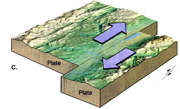
The image shows a plate boundary. Arrows have been added to indicate the movement of the plates.What plate boundary feature is also shown?
A ridge formed by an inactive convergent boundary
A valley forming at an active divergent boundary
A fault forming at an active transform boundary
A volcano formed by an active transform boundary

The map shows the locations of four active volcanoes in the Caribbean Sea. What do these volcanoes indicate about plate tectonics in the region?
The volcanoes form an island arc, indicating a converging plate boundary
The volcanoes form a line, indicating a diverging plate boundary.
Two plates are moving past each other, causing faulting and magma formation.
Two plates are moving apart, creating new seafloor

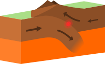
The diagram shows a model of the movement of two tectonic plates. When the plates collide, on plate often moves below the other plate. The rising magma that can result from this type of plate movement may produce-
fossil layers
volcanic islands
deep-sea sediment
seafloor spreading

The model below shows two continental plates. The folded mountains in this model form at which type of plate boundary?
Transform boundary
Divergent boundary
Subduction boundary
Convergent boundary


Scientists recently discovered that rocks collected from the Franklin Mountains in West Texas and rocks collected from mountains in eastern Antarctica were exactly the same age. Further research showed that the rocks were chemically and geologically the same and came from the same magma source. This discovery provides evidence of--
coastal erosion
plate tectonics
ocean currents
glacial melting

A teacher asks students to make a model of a transform plate boundary. The students use blocks to represent tectonic plates and slide the blocks past each other in the directions of the arrows as shown.
Which event can the students best demonstrate with their model?
An earthquake
A volcanic eruption
Formation of a rift valley
Building up of a mountain
A mid-ocean ridge is located at the boundary of two tectonic plates. Which diagram correctly models the relative plate motion on each side of a mid-ocean ridge?


Rift valleys can form when fractures in Earth's crust widen. The valley walls slowly move at a rate of only a few millimeters a year. Which of these best describes the type of tectonic activity that forms rift valleys?
Rift valleys form where a continental plate moves under an oceanic plate.
Rift valleys form where a plate slides horizontally past another plate.
Rift valleys form where two plate move away from each other.
Rift valleys form where an oceanic plate moves under another oceanic plate.

The map shows some of Earth's plate tectonic boundaries.
Based on the map, volcanic activity would likely be found at -
Location W
Location X
Location Y
Location Z

The San Andreas fault is a transform fault. The map below shows a student's approximation of where the fault line crosses through the United States. Students were asked to make maps predicting which way land would most likely move over thousands of years.
Which map best predicts the likely movement of land along the fault line over thousands of years.


A mid-ocean ridge separates the Pacific plate and the Nazca plate off the western coast of South America.
Which statement best describes the relative motions of the Pacific Nazca plates?
The Pacific and Nazca plates are both moving to the east.
The Pacific and Nazca plates are both moving to the west.
The Pacific plate is moving to the west, and the Nazca plate is moving to the east.
The Pacific plate is moving to the east, and the Nazca plate is moving to the west.

The map below shows the locations of four active volcanoes in the Caribbean Sea.
What do these volcanoes indicate about plate tectonics in the region?
The volcanoes form an island arc, indicating a converging plate boundary.
The volcanoes form a line, indicating a diverging plate boundary.
Two plates are moving past each other, causing faulting and magma formation.
Two plates are moving apart, creating new seafloor.

The diagram below shows a model of the movement of two tectonic plates. When the plates collide, one plate often moves below the other plate.
The rising magma that can result from this type of plate movement may produce -
fossil layers
volcanic islands
deep-sea sediment
seafloor spreading

The Himalayan mountains are shown on the map below.
Four students were asked to identify the geologic process that causes this mountain range to form. Their responses are shown in the table.
Which student correctly identified the geologic process that formed the Himalayan mountains?
1
2
3
4

The model below shows two continental plates.
The folded mountains in this model form at which type of plate boundary?
Transform boundary
Divergent boundary
Subduction boundary
Convergent boundary

The thick black lines on the map below show the locations of mid-ocean ridges.
Which geologic feature is most likely to form at a mid-ocean ridge?
Peninsula
Volcano
Delta
Plateau

A river is shown on the topographic map. Four riverbank areas are labeled on the map.
Which two riverbanks are the steepest?
W and X
Y and Z
X and Y
W and Z

This topographic map represents the elevation of an area 100 years ago. At that time the highest point had an elevation of 214 m. The highest point has since eroded a total 7 m.
Which profile most likely represents the landscape today?


The satellite image below shows a portion of the Namib Desert in Africa. This is an ancient, sandy desert with dunes that can be up to 305 m tall. The Namib Desert extends inland from the Atlantic Ocean between 80 km and 200 km and received only 5 mm to 76 mm of rain each year.
A satellite picture of this same area taken weeks before shows that the shape and location of some sand dunes have changed. Which of these most likely caused the changes in the dunes?
Ocean waves
Flowing rivers
Blowing wind
Crustal uplift

A student stands at the point marked X on the topographic map below.
What height in meters must the student climb in order to reach the top of the hill?
250 m
253 m
303 m
50 m

The satellite image below shows a ship channel between South Padre Island and Boca Chica beach on South Texas.
Sand is sometimes removed from the ship channel through a process called dredging to make it easier for ships to travel through. Recently sand from the bottom of the channel was moved to area beaches. Without this transfer of sand, what would most likely occur in this are in the future?
The ship channel would become deeper, and the island would move west toward the mainland.
The ship channel would become shallower, and the beach would become narrower.
The ship channel would become narrower, and the island would become completely covered with water.
The ship channel would become wider, and the island would sink into the Gulf of Mexico.

The points labeled W and Y on the topographic map below show the campsites of two families. Each family hiked to the elevation on the map marked X. The arrows show the paths taken by both families.
What was the change in elevation for the family that took the steepest path to Point X?
60 m
100 m
120 m
600 m

The satellite photograph below shows a large meteorite that is 1200 m in diameter and 170 m deep. This crater is located in a flat, arid part of northeastern Arizona.
How will this crater most likely change over time?
It will get deeper as it fills with water.
It will rise up like a volcanic crater.
It will become less deep as the rim erodes.
It will widen as it fills with lava.

A section of a topographic map is shown below.
What is the difference in elevation in meters between Point X and Point Y on the map?
300 m
360 m
380 m
1600 m

This picture shows scratches in bedrock that were caused by a moving glacier. These scratches are called glacial striations. Glacial striations in the bedrock of South Africa indicate that glaciers once moved across the African continent. The presence of glaciers on the surface of Africa is evidence that---
the tectonic plate under Africa was closer to the South Pole at one time
the equator was not always where it is currently located
volcanoes did not exist until after faults occurred in Earth's crust
the location of the North Pole and the South Pole changed

A topographic map provides details about Emory Peak in Big Bend National Park. A radio tower on Emory Peak is indicated.
Based on the topographic map, if a park ranger hiked due west from the radio tower, the ranger's path would--
cross a canyon with a river running through it
cross another peak in the park
be flat and then go up a steep slope
go down a steep slope and then become flatter

The satellite photograph shows geological features, including a glacier.
As the glacier melts, water travels toward the ocean along the geological feature labeled X. When water erodes soil along this feature, the feature will most likely become--
straight
dry
shorter
wider



The steepest slope on this hill can be found on the side that is facing which direction?

Which side is steeper?
The left side of the hill
The right side of the hill

If sea level always equals (0), and the contour interval is 10 feet how tall is this mountain?
30 ft
40 ft
50 ft
60 ft

Match topographic map #4 with the appropriate profile.
C
D
E
F
A line that connects points of equal elecation on a map
Contour interval
Contour legend
Contour line
Index Contour
The difference in elevation between two adjacent contour lines of a map.
Relief
Space in between
contour line
contour interval
Distance above or below sea level
Relief
Contour line
Altitude
Elevation


A topographic map of a region is provided. Which position indicated by the letters is at an elevation of 475 meters?
W
X
Y
Z

Match topographic map #3 with the appropriate profile.
A
B
C
D



