
 Worksheets
RMS Quarter 3 Review
Total questions: 120
Worksheet time: 2hrs 44mins
Which diagram best illustrates how air rising over a mountain produces precipitation?


Land surfaces of Earth heat more rapidly than water surfaces because
more energy from the Sun falls on land than on water
land has a lower specific heat than water
sunlight penetrates to greater depths in land than in water
less of Earth’s surface is covered by land than by water

The map shows an imaginary continent on Earth. Arrows represent prevailing wind directions. Letters A through D represent locations on the continent. Locations A and B are at the same latitude and at the same elevation at the base of the mountains.
Over the course of a year, compared to location B, location A will have
less precipitation and a smaller temperature range
less precipitation and a greater temperature range
more precipitation and a smaller temperature range
more precipitation and a greater temperature range

The map shows an imaginary continent on Earth. Arrows represent prevailing wind directions. Letters A through D represent locations on the continent. Locations A and B are at the same latitude and at the same elevation at the base of the mountains.
The climate at location C is much drier than at location D. This difference is best explained by the fact that location C is located
farther from any mountain range
closer to a large body of water
at a latitude that experiences longer average annual daylight
at a latitude where air is sinking and surface winds diverge

The cross section represents the windward and leeward sides of a mountain. The arrows show the direction of air movement over the mountain. Points X and Y represent locations on Earth’s surface.
Compared to the temperature and water vapor content of the air at location X, the temperature and water vapor content at location Y are most likely
warmer and wetter
warmer and drier
cooler and wetter
cooler and drier
The planetary surface winds and air currents near Earth’s equator are usually
converging and sinking
diverging and sinking
converging and rising
diverging and rising
Earth’s polar regions have cold, dry climates because the Sun’s rays are at a
low angle, and upper atmospheric air is sinking
low angle, and upper atmospheric air is rising
high angle, and lower atmospheric air is sinking
high angle, and lower atmospheric air is rising
During explosive volcanic eruptions, large amounts of ash entering Earth’s atmosphere often rise to an altitude of 20 kilometers. What is the most likely effect of this ash cloud?
a decrease in the insolation reaching Earth’s surface
a decrease in the thickness of Earth’s stratosphere layer
an increase in the insolation reaching Earth’s surface
an increase in the thickness of Earth’s stratosphere layer
Mount Kilimanjaro is located in eastern Africa at 3° S. Which climate factor best explains the presence of permanent snow on its peak?
latitude
elevation
prevailing winds
ocean currents
In which cross section do the arrows represent the most probable direction of air movement over land and water surfaces at an ocean coast on a hot, sunny, summer afternoon?


Which natural event periodically weakens western surface ocean currents in the equatorial Pacific Ocean, resulting in a change in air temperature and precipitation patterns in the United States?
El Nino
transpiration
ocean tides
volcanic eruptions

The table shows the latitude and the average yearly temperature for four different cities.
It can be inferred from this table that the cities at higher latitudes have
lower average yearly temperatures because these cities receive insolation at a higher angle during the year
lower average yearly temperatures because these cities receive insolation at a lower angle during the year
higher average yearly temperatures because these cities receive insolation at a higher angle during the year
higher average yearly temperatures because these cities receive insolation at a lower angle during the year
Mt. Marcy often has the coldest nighttime temperatures in New York State because of its
latitude and planetary winds
latitude and elevation
longitude and planetary winds
longitude and elevation
Which graph best represents the average monthly temperatures for one year at a location in the Southern Hemisphere?


London, England, is located at approximately 51° 30' north latitude and 0° longitude. Elmira, New York, is located at approximately 42° 10' north latitude and 76° 54' west longitude. What is one reason why London has a warmer average winter temperature than Elmira?
London is located closer to the equator.
London is located at a higher elevation.
London’s climate is modified by the North Atlantic Ocean Current.
London’s climate is modified by its longer duration of insolation.
Two cities are located at the same latitude and elevation. One city, located in the center of the United States, has cooler winters and warmer summers than the other city, which is located near the coast. Which statement best explains these seasonal differences?
The air over continents is drier than the air over oceans.
Cold airmasses usually originate over continents.
A large body of water modifies coastal air temperatures.
Warm ocean currents flow along most coastlines.

The cross section shows how prevailing winds have caused different climates on the windwards and leeward sides of a mountain range.
Why does the windward side of this mountain have a wet climate?
Rising air compresses and cools, causing the water droplets to evaporate
Rising air compresses and warms, causing the water vapor to condense.
Rising air expands and cools, causing the water vapor to condense.
Rising air expands and warms, causing the water droplets to evaporate.

During which season does city B usually experience the month with the highest average precipitation?
spring
summer
fall
winter

City A has very little variation in temperature during the year because city A is located
on the dry side of a mountain
near the center of a large landmass
on the wet side of a mountain
near the equator

It can be concluded that city C is located in the Southern Hemisphere because city C has
small amounts of precipitation throughout the year
large amounts of precipitation throughout the year
its warmest temperatures in January and February
its warmest temperatures in July and August

Which event is inferred by most scientists to be responsible for a climate change that has recently led to a decrease in the size of most glaciers?
a decrease in the rate of divergence of lithospheric plates along a mid-ocean ridge
a decrease in the amount of insolation reaching Earth's surface
an increase in the amount of greenhouse gases in Earth's atmosphere
an increase in the amount of vegetative cover in the tropics
Adjacent water and landmasses are heated by the morning Sun on a clear, calm day. After a few hours, a surface wind develops. Which map best represents this wind's direction?


Arrows on the maps below show differences in the direction of winds in the region of India and the Indian Ocean during January and July. Isobar values are recorded in millibars. Heavy monsoon rains usually occur in India during
January, when winds blow from the land
January, when winds blow toward high pressure
July, when winds blow from the ocean
July, when winds blow toward high pressure
What is climate?
the condition of the atmosphere at any given time and place
cloud cover and temperature
precipitation and humidity at a given time and place
weather conditions in an area over a long period of time
Climate is affected by many factors including:
latitude, elevation, and proximity to bodies of water
tides and currents
wind
snow and sleet
Which two factors determine the climate in a particular region?
temperature and latitude
precipitation and humidity
temperature and precipitation
humidity and air pressure
What is a sea breeze?
cooler air moving inland from the ocean
warmer air moving inland from the ocean
cooler air moving to sea
warmer air moving to sea
How do ocean currents affect climate?
they cause hurricanes
they spread temperatures around the Earth a little bit more evenly
they make the Equator closer to Earth
they cause the seasons

Surface currents are driven by _____________.
sea critters
differences in temperature
wind
the Equator
Because water ___________, ocean currents have a great effect on climate.
cannot hold heat
hold large amounts of heat
moves more slowly than air
stays colder than air
On a climograph the Line Graph measures?
Precipitation
Temperature
Large bodies of water such as oceans or lakes ________________ temperatures.
Raise
Lower
Moderate or Even out
Don’t change


What is the process during which water cools and turns from a gas to a liquid forming clouds?
Codensation
Runoff
Precipitation
Evaporation

Which climograph has the most precipitation during the summer?
A
B
C
D

Which climograph do you think matches the place in the picture?


Generally speaking, the primary factor controlling climate zones is
Longitude
Latitude
Time
Elevation

The leeward side of the mountain in in the
rain shadow
way
river
rainbow
As air rises, it expands. This expanding air also ______.
warms and condenses
cools and condenses
A rain shadow forms on the ___________ side of a mountain as a result of ___________ rainfall there.
windward; more
windward; less
leeward; more
leeward; less

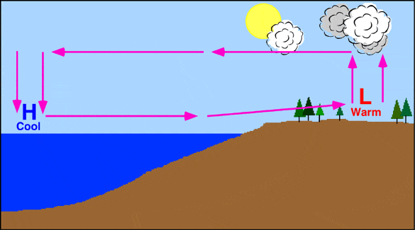
The arrow above the land is going up and is red because
the land is warm so it warms the air and warm air rises.
the land is cold so it warms the air and cool air sinks.
the land is cold so it cools the air and cool air sinks.
the land is warm so it warms the air and cool air rises.

A Sea Breeze occurs during the
night.
day.
night and day.
alien encounter.
Air moves from areas of ____ pressure to areas of _____ pressure.
H ; H
L ; H
L ; L
H ; L
Which side of the mountain usually gets deserts and why?
windward, because of rising, moist air
leeward, because of rising, dry air
windward, because of sinking, moist air
leeward, because of sinking, dry air

The ocean conveyor belt is
a belt that carries minerals to the poles and the equator
world wide circulation system
the Pacific ring of currents that distribute heat and energy
A high range of mountains

The curved paths of the planetary winds are a result of

On which side of the mountian would you most likely find dry, desert conditions?
A
B


Both El Nino and La Nina have this in common
Influence birds that migrate over the ocean
Influence rainy / dry weather world wide
The weather at the polar regions
The directions that ships travel in the oceans
How often do El Nino events occur?
2-5 years
2-7 years
7-10 years
Why do the fisherman of Peru and South America not welcome a strong El Nino?
El Nino poisons the fish
El Nino causes strong winds and currents which move fish westward
El Nino bring cold water to the surface which kills the base of the food chain
El Nino shuts off upwelling and nutrients needed for the marine food chain do not rise to the surface
El Niño ___________________ the trade winds causing the warm pool to move ___________.
weakens or reverses; west
intensifies; east
weakens or reverses; east
intensifies; east
During a(n) ____ event, trade winds are much stronger than usual.
El Nino
La Nina
Normal
Partly sunny
During an El Nino, trade winds are typically...
about average
stronger
weaker

The picture represents a(n) ___ event.
El Nino
La Nina
Non-El Nino (normal conditions)
La Niña is characterized by ______________ of the Western Pacific Ocean.
a warming
a cooling
average temperatures

A monsoon is a
seasonal wind
tornado
wild fire
explosion
What is the amount of air space in soil or rock?
Porosity
Permeability
What is the rate (how fast) water can go through the pores of a rock?
Porosity
Permeability
If water cannot go through a substance what would it be called?
Permeable
Impermeable
If something has high porosity and permeability then ________________.
Water can flow through easily
Water can not flow through it
Where is groundwater stored?
Lakes
Rivers
Aquifers
Glaciers
While digging a deep hole you may eventually find water. What is that line called right when you hit the water?
Zone of Aeration
Zone of Saturation
Water Table
Impermeable Layer
Which area of the ground is completely filled with water?
Zone of Aeration
Zone of Saturation
Water Table
Impermeable Layer

What does area #1 represent?
Zone of Aeration
Zone of Saturation
Water Table
Impermeable Layer
What does area #2 represent?
Zone of Aeration
Zone of Saturation
Water Table
Impermeable Layer
What does area #3 represent?
Zone of Aeration
Zone of Saturation
Water Table
Impermeable Layer
Which area had no porosity and is impermeable?
1
2
3
4


Flash flooding often occurs in city areas because
Roads, pavements, and buildings reduce the infiltration of water into the ground
Ground water storage is usually very large
runoff decreases during precipitation
The heat generated by city areas decreases actual evapotranspiration

As permeability increases
Infiltration decreases and runoff decreases
Infiltration increases and runoff decreases
Infiltration decreases and runoff increases
Infiltration increases and runoff increases
If water can easily move between cracks of a rock, we can say that...
water is permeable
rock is permeable
rock is impermeable
water is impermeable
What affect does particle size have on permeability
No effect
The larger the particles the lower the permeability
The larger the particles the higher the permeability
The smaller the particles the higher the permeability


Base your answer on the graph below which shows the changes in relative humidity and air temperature during a spring day in Washington, D.C
What were the relative humidity and air temperature at noon on this day?
47% and 32°F
65% and 32°F
47% and 48°F
65% and 48°F
The amount of water vapor in the air is known as ___.
dew point
humidty
relative humidity
rain
Which will hold more water, warm air or cold air?
Warm Air
Cold AIr
The amount of water vapor in the atmosphere compared to the maximum amount it could hold is known as...
Saturation
Vaporicity
Absolute Humidity
Relative Humidity

What does high absolute humidity mean?
It is cold.
It is hot.
There is a little water vapor in the air.
There is a lot of water vapor in the air.
Convert 45°F into °C.
7.2°C
32°C
32°F
212°F
Convert 89°F into °C.
7.2°C
32°C
32°F
212°F
Convert 0°C into °F.
7.2°C
32°C
32°F
212°F
Convert 100°C into °F.
7.2°C
32°C
32°F
212°F
Which of these statements BEST describes (explains) temperature as elevation in the atmosphere increases?
Temperature remains constant with elevation in the thermosphere.
Temperature remains constant with elevation in the mesosphere.
Temperature generally decreases with elevation in the stratosphere.
Temperature generally decreases with elevation in the troposphere.
Which graph BEST illustrates (shows) the change in density in the lowest layer of Earth’s atmosphere as altitude increases?


In which layer of Earth’s atmosphere does weather occur?
mesosphere
stratosphere
thermosphere
troposphere
Convert
100oC to Kelvin373 K
273 K
212 K
0 K
Convert
300 K to Celsius573oC
37oC
27oC
600oC
What is the freezing/melting point of water of the Fahrenheit scale?
−273oF
0oF
32oF
273oF

