
 Worksheets
Practice Test--Plate Tectonics: Earth's Living Crust
Total questions: 67
Worksheet time: 5hrs 34mins


What evidence did Wegener use to support his theory of continental drift?
Continents and fossils fitting together/matching-up like puzzle pieces
glacier scars and other climate evidence from temperature
mountain ranges and rocks line up across continents
all of the above

Where did Wegener find plant fossils that today would not be able to survive on that type of land and extremely cold climate?
North America
Antarctica
China
India

Originally the Continental Drift theory was not well received by other scientist. Why?
There was a competing theory at the time that was more believable.
There was no data showing the continents ever moved.
Wegener could not explain how the continents were moving and did not know the force responsible for moving the continents.
The other scientists did not like Wegener and thought his data was unreliable.

Most tectonic plates have both oceanic and continental crust. How are these crust types different?
Oceanic is thinner and less dense than continental.
Continental is thinner than more dense than oceanic.
Continental is thicker and less dense than oceanic.
Oceanic is thicker and more dense than continental.

What type of thermal energy causes plate movement?
Conduction
Convection
Radiation
Conveyor belts

True of False: The continents have always been where they are today.
True
False

One difference between continental drift theory and plate tectonics theory is that plate tectonics includes seafloor spreading as an explanation of for plate movement.
true
false
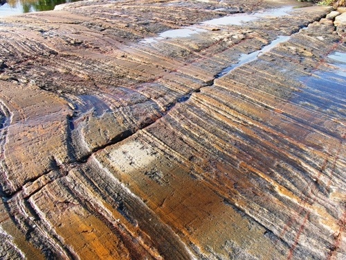
This is a picture of glacier* scars found in rocks in Africa. This is evidence that...
(*A glacier is a thick sheet of moving ice that forms over many years.)
Africa has always been near the equator
Africa was once in an area of the Earth that had a very cold climate
The continents have not moved
sea floor spreading
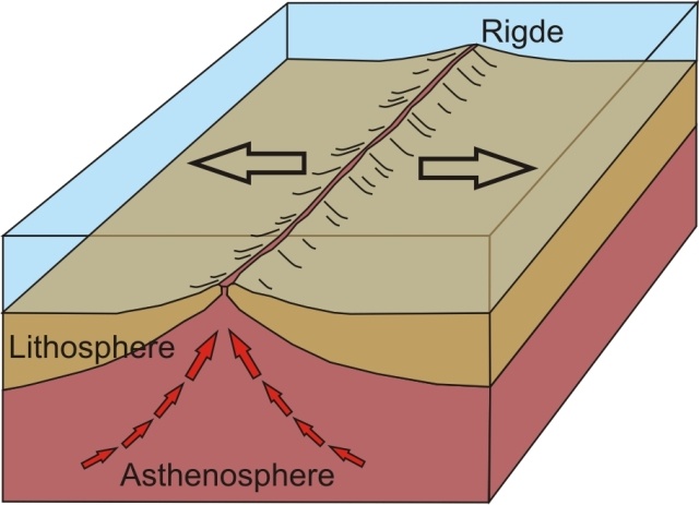


How do GRAVITY and DENSITY determine which lithospheric (or tectonic plate) subducts under the other plate?
Ocean waters are colder, deeper, and denser than continental plates; so, they always press the lighter continental plate down.
Subduction is primarily based on which plate is denser. The basalt rocks that make up most oceanic crust are denser. Gravity affects matter with higher density more than matter than is less dense, so oceanic plates subduct.
Continental crust is thicker, which makes it heavier than oceanic crust 'cause there is more matter in the same volume.
Temperature is the only determining factor.

What geologic feature/event you be most likely to find at a transform boundary such as the San Andreas Fault?
Earthquakes
Volcanoes
Mountains
Rift Valleys
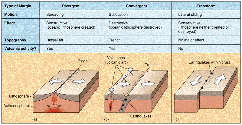
What geologic feature would you most likely to find at a divergent boundary between two pieces of oceanic crust?
Rift Valley
Mid-Ocean Ridge
Island Arc
Flat land
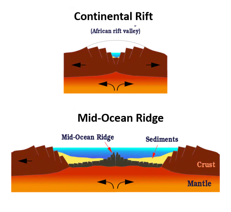
What geologic feature/event would you most likely to find at a divergent boundary between two pieces of continental crust?
Mid-Ocean Ridge
Mountain
Rift Valley
Island Arc
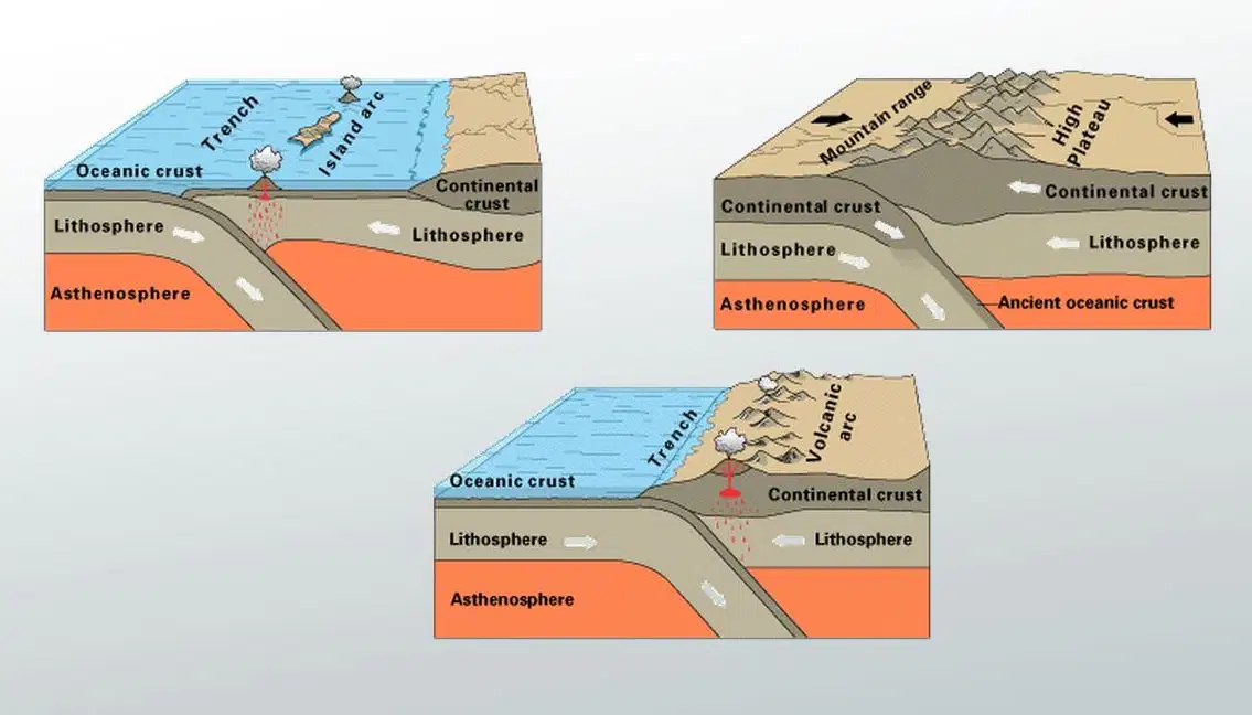
What geologic feature/event would you most likely to find at a convergent boundary between two pieces of continental crust?
Volcano
Mountain
Rift
Island Arc

New oceanic crust (sea floor) is created at this boundary.
Divergent Oceanic
Divergent Continental
Convergent Oceanic
Transform

Oceanic crust (sea floor) is destroyed at this boundary.
Convergent Oceanic
Divergent Oceanic
Convergent Continental-Continental
Divergent Continental

What two crust features occur near every subduction zone?
Volcanoes and Trenches
Rift Valleys and Mid Ocean Ridges
Volcanoes and Rift Valleys
Mid Ocean Ridges and Trenches
When two continental plates converge (collide) what type of crustal feature is formed?
Mid Ocean Ridge
Subduction Zone
Rift Valley
Folded Mountains
The process that occurs at a divergent oceanic boundary that creates new crust (sea floor) is called?
Subduction
Seafloor Spreading
Continental Drift
Volcanism
The type of crust that will subduct if two plates converge is...
Oceanic
Continental

The outermost, rigid layer of the Earth, consisting of the Earth's crust and upper part of the mantle is known as the ________________.
lithosphere
Pangaea
subduction zone
tectonic
Wegener
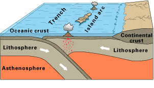
Look at this diagram of a plate boundary. Which statement BEST describes what is happening?
Tthe oceanic crust is melting.
The denser oceanic crust is subducting under the less dense oceanic crust.
Volcanic islands are forming.
The tectonic plates are moving away from each other.

The San Andreas Fault in California is known as an active earthquake area. What type of boundary is it?
Converging
Diverging
Transform
Sea Floor Spreading
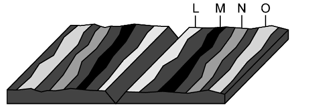
Look at the picture carefully.
Where would the oldest rock be found?
L
M
N
O

How is it possible for new crust to be formed without increasing the surface area of the Earth?
Crust is destroyed at subduction zones. At the same time, crust is created at ridges and trenches.
New crust is underwater where it sinks.
New crust breaks more easily than old crust.
False; The surface area of the Earth has actually been increasing over the last 3 billion years.


In some areas of the world, like California and Japan, earthquakes are a common occurrence. How can this best be explained?
The strong ocean currents are undermining both areas causing earthquakes.
Both areas are located near the edge of the Pacific Ocean, the unstable sand causes earthquakes.
Both areas are subjected to strong ocean wind and waves that causes earthquakes.
Both areas are on the boundary of active plates, the motion of the plates causes earthquakes.
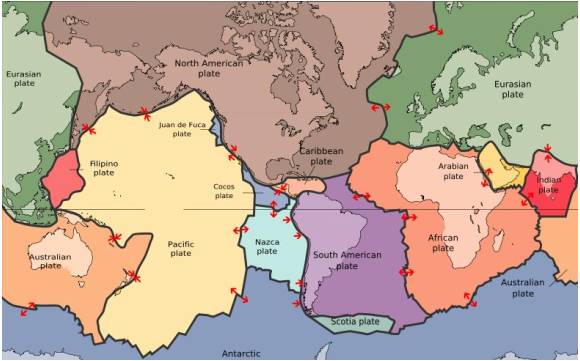
The map in the picture shows tectonic plate boundaries. This map would be useful in predicting the location of future
droughts (no rain)
hurricanes
earthquakes
tornadoes
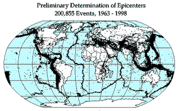
Earthquake epicenters (center of where the earthquakes started) were mapped for a 35 year period in the diagram above. The black dots indicate these epicenters. The black dots appear along what feature on Earth?
hot spots
plate boundaries
rift zones
sea floor spreading
Look at this diagram of a plate boundary. Which statement BEST describes what is happening?
Tthe oceanic crust is melting.
The denser oceanic crust is subducting under the less dense oceanic crust.
Volcanic islands are forming.
The tectonic plates are moving away from each other.
In some areas of the world, like California and Japan, earthquakes are a common occurrence. How can this best be explained?
The strong ocean currents are undermining both areas causing earthquakes.
Both areas are located near the edge of the Pacific Ocean, the unstable sand causes earthquakes.
Both areas are subjected to strong ocean wind and waves that causes earthquakes.
Both areas are on the boundary of active plates, the motion of the plates causes earthquakes.

The Atlantic Ocean gets about 5 cm wider each year. One inch = approximately 2.5 cm. Which answer below shows a correct way to calculate the Atlantic Ocean's growth in 50 years?
You may use the calculator on your chrome book
5 cm×50 years =250 cm or 25 m
5 cm × 50 years; 50 years ÷100 cm =.5 years; 5cm ×.5 = 2.5 m
5 cm ×50 years =250 cm; 250 cm ÷5 = 50 cm; 50 cm ÷2.5 inches =20 inches
5 cm ×50 years =250 cm. 250 cm÷2.5 inches = 100 inches approximately
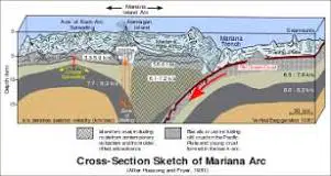
The Marianas Trench, where the Pacific Plate descends under the edge of the Philippines Plate, is the deepest sea location in the world.
These ocean trenches form when two oceanic plates collide ...
and the younger, less dense of the two plates rides over the edge of the older plate.
when convection currents in the mantle force the older plate downward.
and the denser Pacific Plate is subducted beneath the less dense Philppines Plate.
and the plates are approximately the same age and density.

Why is it important to be aware of places prone to earthquakes?
to identify what crop must be stored
to identify when to evacuate
to locate where to go on vacation
to be ready for emergencies and build safer buildings

The Hawaiian islands have formed as the Pacific plate moves over ________. The longer it takes the plate to move, the larger this feature can grow.
a subduction zone
an ocean ridge
the Aleutian plate
a hot spot
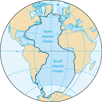
Towards the edges, near the eastern and western continents because the oldest crust is formed as magma rises to the seafloor.
Towards the middle of the ocean because new crust forms from magma upwellings along the center of the ridge.
Towards the north and south poles because of magnetic revearsal.
Young seafloor is located randomly throughout the ocean

The magnetic pattern or stripes of rocks on one side of the mid-ocean ridge are_____________.
the same as the rocks on the other side because the magma that forms new crust CONTINUALLY rises in the center of the ridge (before SPREADING APART BY NEW UPWELLING.)
younger than other side because magnets are ALWAYS separated by north and south poles.
unpredictable and much different patterns over billions of years.
at right angles to the ridge.

The rocks on the ocean floor show evidence that the magnetism alternates North and South as you move along the sea-floor. This evidence of sea-floor spreading is reflected in the rocks on the ocean floor. The name for this evidence is called?
Crustal subtraction
Magnetic Reversals
plate motion
magnetic soldification


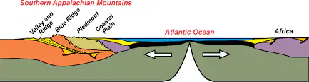
Which of these is evidence that North America and Africa collided as Pangea formed about 270 million years ago.
Chesapeake Bay
Florida Peninsula
Appalachian Mountains
Great Dismal Swamp

Earth is approximately 4.5 billion years old, and
Pangaea is the only supercontinent to have existed. Before Pangaea, the Earth was all ocean.
True
False

Since tectonic plates are continuing to move, the continents will probably again form a single supercontinent in the middle of super ocean in the future.
True
False
Extend your thinking: Which is the most likely map of Earth 300 million years from now?


Earth is approximately 4.5-4.6 BILLION years old. The supercontinent Pangaea existed approximately 200-300 years ago. Which of the answers is most likely accurate?
Earth is a closed system in which everything cycles and recycles. Therefore, it is certain that over time land formed beneath the oceans and gradually rose to the surface to form continents.
Earth is a closed system in which everything cycles and recycles. Therefore, it is certain that over time convection currents in the asthenosphere would have been moving tectonic plates in the crust and kept Earth's surface changing. Previous supercontinents are likely to have formed.
It's not possible to predict something like this because Earth's crust is continually recycled COMPLETELY and all the "evidence" is destroyed.
20-30 billion years ago, the Big Bang sent matter flying everywhere across the universe. So, new matter would definitely have struck Earth and created new land forms.
Choose TWO: Which force and characteristic of matter are most likely to be part of correct answers on the Virginia Earth Science SOL? (according to your teacher)
density
gravity
inertia
mass
volume


L waves

Visual Vocabulary Question—Read the picture: Liquefaction is when...
the soil behaves like liquid
the ground becomes solid from pressure waves
magma rises to the surface
buildings are damaged, crumbling like liquid

The most destructive type of seismic wave is a
P-wave (or Primary wave)
S-wave (Secondary wave)
Surface wave (L or Longitudinal wave)
To triangulate the epicenter of an earthquake, how many seismographs are needed?
1
2
3
4

What TWO factors influence the heating and cooling of convection currents?
Density
Fusion
Gravity
Verticality

Choose THREE correct answers: What makes it possible for seismologists to locate the epicenter of an earthquake?
P and S waves travel at different speeds.
P waves can travel through solids and liquids.
S waves can travel only through solids.
P and S waves that reach the seismograph at the SAME time show the focus.

Which location is farther from the epicenter?
Seismogram B (top)
Seismogram C (bottom)

Which location would experience a more intense earthquake?
Seismogram A (top)
Seismogram B (bottom)

Which letter represents surface waves?
A
B
C
All are surface waves

This model demonstrates a
P wave shadow zone
S wave shadow zone
Surface wave shadow zone
Convection currents

This model represents a
P wave shadow zone
S wave shadow zone
Surface wave shadow zone
Convection currents
If the Earth did NOT have a liquid outer core, how would earthquake waves travel differently?
P and S waves would both be absorbed.
Only S waves would travel through the Earth's core.
Shadow zones would not exist.
S waves would travel faster than P waves.


Recall Question! What is the formula for calculating (finding) density?
D=m/v
D=v/m
D=mv
D=mv/2
Select the layers of the Earth in order of increasing density:
inner core, outer core, mantle, crust
crust, mantle, outer core, inner core
crust, mantle, inner core, outer core
mantle, crust, core

What is the relationship between the arrival of a P-wave and an S-wave?
The greater the difference in the time of arrival, the closer the location is to the earthquake.
The smaller the difference in the time of arrival, the further away the location is to the earthquake.
The greater the difference in time of arrival, the further away the location of the earthquake is.

What causes matter to rise?
Heat decreases the density of matter by increasing volume.
Heat decreases the density of matter by decreasing volume.
Heat increases the density of matter by increasing volume.
Heat increases the density of matter by decreasing volume.

