
 Worksheets
Chapters 9-10 Test Review
Total questions: 99
Worksheet time: 8hrs 15mins
The center of mass of the Earth-Moon system is called the ________.
aphelion
apogee
barycenter
perigee
perihelion
The barycenter follows ________.
a path that is perpendicular to the Earth's ecliptic
a pattern that parallels the Moon's orbit
a smooth orbit around the Sun
a wavy path around the Sun
the Earth's declination
If the side of the Earth that faces the Moon experiences a high tide, then the side of the Earth that is opposite from the Moon will have a ________.
high tide
low tide
neap tide
proxigean tide
spring tide
A full lunar tidal cycle is ________.
12 hours in duration
12 hours 25 minutes in duration
24 hours in duration
24 hours and 50 minutes in duration
48 hours in duration
When the tides appear to move water in toward the shore it is called ________.
Flood tide
Ebb tide
Lunar tidal bulge
Solar tidal bulge
When the tides appear to move water away from shore it is called ________.
Flood tide
Ebb tide
Lunar tidal bulge
Solar tidal bulge
A(n) ________ is the time that elapses between when the Moon is directly overhead and the next time the Moon is directly overhead.
Solar day
Martian day
Lunar day
Earth day
Which of the following best explains why there is a difference between a lunar day and a solar day?
During one Earth rotation, the Moon has continued orbiting Earth.
The Moon must rotate an additional 50 minutes to catch up to Earth.
The solar day and lunar day are measured from different meridians.
The Sun has a stronger pull on the larger Earth versus the smaller Moon.
The tide-generating forces of the Sun and Moon are working at right angles.
Compared with a solar day, a lunar day is ________.
equal to a solar day
half the length of a solar day
longer than a solar day
shorter than a solar day
twice the length of a solar day
The vertical difference between consecutive high and low tides is called the ________.
ebb tide
flood tide
todal bore
tidal height
tidal range
A spring tide ________.
has moderate high and low tides
occurs at a blue moon
occurs at the vernal equinox
has very high high tides and very low low tides
has very little difference between high and low tides
Spring tide occurs about ________.
once per month
once per season
once per year
twice per month
twice per year
A neap tide has ________.
moderately high tidal range
moderately low tidal range
no tidal range
very high tidal range
very low tidal range
Neap tides occur ________.
at summer and winter solstice
during a storm surge
when the Moon is full or new
when the Moon is in quadrature
when the Sun is at perihelion or aphelion
When the Earth is at its greatest distance from the Sun, it is said to be at ________.
apogee
aphelion
perigee
perihelion
proxigean
Tidal ranges will be greatest when the Earth and the Moon are at ________.
Perihelion
Aphelion
Perigee
Apogee
Proxigean
Tidal ranges will be smallest when the Earth and the Moon are at ________.
Perihelion
Aphelion
Perigee
Apogee
Proxigean
Tidal ranges are the smallest when the Earth is near its most distant point (from the Sun) called ________.
Perihelion
Aphelion
Perigee
Apogee
Proxigean
The Moon cycles between perigee, apogee, and back to perigee every _______.
27 days
27.5 days
28 days
28.5 days
29 days
At ________, half of the Moon's sunlit face is visible.
New Moon
First quarter
Full Moon
Waxing gibbous
Waxing crescent
At ________, the entire Moon's sunlit face is visible.
Full Moon
New Moon
First quarter
Third quarter
Waning crescent
Between the Moon's full and third-quarter phases, it is a ________.
Waxing gibbous
Waning gibbous
Waning crescent
Waxing crescent
Examine the five words and/or phrases and determine the relationship among the majority of words/phrases. Choose the one option that does not fit the pattern.
Full Moon
Neap tide
New Moon
Spring tide
Syzygy
Examine the five words and/or phrases and determine the relationship among the majority of words/phrases. Choose the one option that does not fit the pattern.
Aphelion
Nadir
Apogee
Perigee
Perihelion
There is constructive interference between the lunar and solar tidal bulges during ________ tides.
fall
neap
spring
summer
winter
There is destructive interference between the lunar and solar tidal bulges during ________ tides.
fall
neap
spring
summer
winter
The center of an open ocean tidal system is called a(n) ________.
amphidromic point
cotidal center
rotary center
seiche
tidal flux
A detailed analysis of all the variables that affect the tides at any particular coast reveals that nearly ________ factors are involved.
100
200
300
400
500
An area that experiences semidiurnal tides will have ________.
one high tide and one low tide daily
one high tide and two low tides daily
one low tide and two high tides daily
two high tides and two low tides of nearly equal height daily
two unequal low and high tides daily
An area that experiences diurnal tides will have ________.
one high tide and one low tide daily
one high tide and two low tides daily
one low tide and two high tides daily
two high tides and two low tides of nearly equal height daily
two unequal low and high tides daily
The most common tidal patterns around the world are _______.
diurnal tides
mixed tides
proxigean tides
semidiurnal tides
spring tides
In the United States, semidiurnal tides commonly occur along the _______.
Atlantic coast
Gulf of Alaska
Gulf of Mexico coast
Florida Keys
Pacific coast
In the United States, mixed tides commonly occur along _______.
the Atlantic coast
Cape Cod
the Gulf of Mexico coast
the Florida Keys
the Pacific coast
Diurnal tides have a tidal period of _______.
24 hours
24 hours 30 minutes
24 hours 50 minutes
25 hours 30 minutes
26 hours
Semidiurnal tides have a period of _______.
12 hours
12 hours 25 minutes
12 hours 50 minutes
13 hours
13 hours 25 minutes
Mixed tides have a period of _______.
12 hours
12 hours 25 minutes
12 hours 50 minutes
13 hours
13 hours 25 minutes
Which of the following coasts is an example of a diurnal tidal pattern?
East Coast of The United States
Gulf of Mexico
West Coast of Africa
West Coast of South America
West Coast of The United States
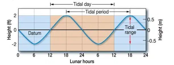
The graph shown is an example of which of the following tidal patterns?
Diurnal Tidal Pattern
Mixed Tidal Pattern
Quadrantal Tidal Pattern
Semidiurnal Tidal Pattern
Trimester Tidal Pattern
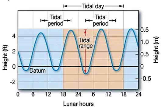
The graph shown is an example of a ______ tidal pattern.
diurnal
mixed
quadrantal
semidiurnal
trimester
The Bay of Fundy is well known for which tidal characteristic?
A diurnal tide
Two amphidromic points
Very large seiche
Very low tidal range
Very high tidal range
Which of the following produces a tidal current?
Both ebb tides and flood tides
Both neap tides and spring tides
Ebb tide
Flood tide
Spring tide
A grunion is a marine ________ that comes completely out of the water to spawn.
fish
eel
shark
crab
turtle
Grunion are common in which state?
New York
California
Tennessee
Nevada
Texas
Where are the largest tidal bores in the world located?
Europe
China
Africa
United states
Australia
The ________ is the longest estuary affected by oceanic tides.
Nile River
Amazon River
Tygarts River
Yangtze River
Mississippi River
A(n) ________ is produced when water rushes into a bay (or river) with an incoming high tide.
rotary current
reversing current
flood current
ebb current
A(n) ________ is produced when water drains out of a bay (or river) because a low tide is approaching.
rotary current
reversing current
flood current
ebb current
The Maelstrom off the coast of ________ is one of the strongest whirlpools in the world.
Canad
Italy
Japan
Norway
Scotland
Whirlpools can be created in some restricted shallow passages due to ________.
a vertically mixed estuary
reversing tidal currents
tidal bores up low-lying rivers
tsunamis or tidal waves
wave refraction
A wave formed on a river by a flood current is called a(n) ________.
ebb tide
flood tide
seiche
tidal bore
tsunami
Which of the following statements comparing a tidal power electricity-generating with a conventional thermal power plant is correct?
The initial cost of building a tidal power electricity-generating plant may be lower.
The operating costs of a tidal power electricity-generating plant are higher.
The periodicity of the tides is an advantage of a tidal power electricity-generating plant.
Tidal power initially requires fossil or nuclear fuels to get started.
Tidal power is considered a cleaner and renewable resource.
The section of the coast that is exposed at low tide and submerged at high tide is called the __________.
backshore
foreshore
nearshore
offshore
shoreline
The particle size on a beach __________.
can be related to the frequenc of storms
is a function of the type of bedrock underlying the coastal area
is related to whatever material is locally available
shows seasonal variation only on low energy coasts
varies only with storm intensity and duration
A __________ is a deposit of shore area.
beach
berm
longshore bars
wave-cut bench
backshore
The __________ is the dry, gently sloping, slightly elevated margin of the beach that can be found at the foot of coastal cliffs or sand dunes.
beach
berm
longshore bars
wave-cut bench
backshore
The __________ marks the boundary between the shore and the coast.
shore
coast
coastline
beach
berm
Which feature is not part of the beach?
breakers
foreshore
low tide
high tide
coast
The zone that lies between the lowest tide level and the highest elevation on land that is affected by storm waves is known as the ________.
beach
coast
coastline
shore
wave front
The part of the shore that is above the high tide shoreline and is covered with water only during storms is known as the ________.
backshore
foreshore
nearshore
offshore
shoreline
The part of the shore that represents the water's edge and migrates back and forth with the tide is known as the ________.
backshore
foreshore
nearshore
offshore
shoreline
The part of the shore that extends seaward from the low tide shoreline to the low tide breaker line is known as the ________.
backshore
foreshore
nearshore
offshore
shoreline
The part of the shore beyond the low tide breaker line and is deep enough that waves rarely affect the bottom is known as the ________.
backshore
foreshore
nearshore
offshore
shoreline
About what percent of the world fishery is obtained within 320 kilometers (200 miles) of shore?
5%
25%
55%
75%
95%
Which of the following statements about coastal waters is correct?
Coastal waters are of minor importance for shipping because they traverse the open ocean.
Coastal waters have limited opportunities for oil production and recreational activities.
Coastal waters only support about 15% of the total mass of life in the oceans.
Coastal waters receive land-derived pollutants after passing through the open ocean.
Coastal waters serve as nursery grounds for many species that inhabit the open ocean.
Smaller, low-energy waves move sand up the beach face toward the berm to create a ________.
summertime beach
wintertime beach
springtime beach
autumn time beach
Larger, high-energy waves scour sand from the berm and create a ________.
summertime beach
wintertime beach
springtime beach
autumn time beach
Both longshore currents and longshore transport occur only within the ________.
breaker zone
swash zone
The longshore current generally flows in which direction along both the Atlantic and Pacific Coasts of the United States?
Northward
Southward
Eastward
Westward
Where does sand accumulate during heavy wave activity?
Along the beach face
Behind the dunes
Beneath the breakers
In the berm
Offshore sand bars
Where does sand accumulate during light wave activity?
Along the beach face
Behind the dunes
Beneath the breakers
In the berm
Offshore sand bars
Which of the following occurs during light wave activity?
A backward movement of sand along the beach face
A net movement of sand down the beach face
Backwash dominates the transport system
Much of the swash soaks into the beach
The beach is saturated with water from previous waves
Which of the following occurs during heavy wave activity?
A backward movement of sand along the beach face
A net movement of sand down the beach face
Backwash dominates the transport system
Much of the swash soaks into the beach
The beach is saturated with water from previous waves
Which of the following best describes littoral drift?
The building of a berm at the expense of a longshore bar caused by light wave activity
The formation of a rocky flattened beach face with a narrow berm
The formation of a sandy steep beach face with a wide berm
The movement of sediment in a zigzag fashion caused by the longshore current
The use of floating objects such as shoes from shipping mishaps to track currents
Sediment is supplied to the coastal zone by ________.
coastal erosion
local biological activity
rivers
coastal erosion, local biological activity and rivers are sources of sediment in the coastal zone.
only coastal erosion and local biological activity are sources of sediment in the coastal zone.
Eroded material is carried along coastlines from high-energy wave areas to _______.
active offshore berms
low-energy wave areas
the backshore
the foreshore
the nearshore zone
Which of the following is found at a depositional shore?
Headlands
Wave-cut cliffs
Deltas
Sea caves
Sea arches
Narrow currents flowing across the surf zone toward the open ocean are called _______.
longshore currents
nearshore currents
rip currents
surf flow
swash
A linear ridge of sediment attached to land at one end might be called a _______.
barrier island
bay barrier
bay-mouth bar
spit
tombolo
If one were to walk from the ocean landward across a barrier island complex, in which order would one encounter the following environments?
Beach, dune, barrier flat, low marsh, high marsh
Dune, barrier flat, beach, high marsh, low marsh
Beach, dune, barrier flat, high marsh, low marsh
Low marsh, high marsh, barrier flat, dune, beach
The area of the barrier island complex that would contain thickets and woodlands would be the _______.
dune
high marsh
lagoon
low marsh
Large deposits of sediment at the mouths of rivers are called ________.
barrier flats
barrier islands
bay-mouth bars
deltas
tombolos
Which of the following is not an erosional feature?
Cliffs
Spits
Sea arches
Sea stacks
Marine terraces
Which of the following is not a depositional feature?
Spits
Tombolos
Marine terraces
Barrier islands
Deltas
Which river system has the largest known delta?
Colorado River
Mississippi River
Ohio River
Hudson River
Missouri River
Which of the following is not a feature of a barrier island?
Dunes
Barrier flat
Spit
Salt marsh
Lagoon
Examine the five words and/or phrases and determine the relationship among the majority of words/phrases. Choose the one option that does not fit the pattern.
Marine terrace
Sea arches
Sea caves
Tombolo
Wave-cut cliffs
Examine the five words and/or phrases and determine the relationship among the majority of words/phrases. Choose the one option that does not fit the pattern.
Marine terrace
Sea arches
Sea caves
Tombolo
Wave-cut cliffs
Which of the following can help prevent beach starvation?
Beach replenishment
Damming a river
Disrupting longshore transport
Lining a river with concrete
Sand and gravel mining
Isostatic movement of a coastline might occur due to ________.
increased glacial melting due to global warming
rise in sea level due to a large weight of a glacier on a continental mass
sinking of the crust due to increases in sediment load
uplift related to earthquake activity
volcanic activity resulting in the formation of new continental crust
Eustatic changes in sea level might include ________.
additional seawater
changes in the rate of seafloor spreading
the removal of a large glacier that rested in that area
underwater landslides
uplift related to earthquake activity
Which of the following occurs when seafloor spreading rates increase?
New continental crust forms.
Sea level falls.
Subduction increases.
There is a rise in sea level.
There is no change in sea level.
Sea level began to rise about ________ years ago as the glaciers melted and water returned to the oceans.
18,000
19,000
20,000
21,000
22,000
Which of the following is a feature of an emerging shoreline?
Marine terraces
Drowned beaches
Drowned river valleys
Submerged dune topography
Which of the following is a feature of a submerging shoreline?
Drowned beaches
Marine terraces
Wave-cut beaches
Stranded beach deposits
Which U.S. coast is considered an emerging shoreline?
Atlantic coast
Pacific coast
Gulf coast
Which of the following is designed to prevent or slow down shoreline erosion?
Beach nourishment
Groin
Seawall
All of these are used to try to prevent or slow down shoreline erosion.
Both the groin and seawall prevent or slow down shoreline erosion.
In terms of erosion protection from wave action, seawalls __________.
lead to erosion of sediment on their seaward sides
result in a more gradual seaward slope of beaches
are permanent and thus never need to be replaced
require very little maintenance
Which of the following is an example of hard stabilization?
Seawalls
Beach replenishment
Construction restrictions
Relocation
Beach renourishment
Which of the following is not a hard stabilization option?
Groins
Jetties
Relocation
Breakwaters
Seawalls

