
Font size
 Worksheets
Year 7 OS maps Quiz
Total questions: 114
Worksheet time: 2hrs 31mins
A map _________ has symbols in it to identify objects on a map.
rose
section
key
symbol

What is this?
Compass Rose.
Map Scale.
Map Key.
Antiquity
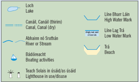
A _________ is used to represent real objects on the map such as a building, road, lake, tree, mountain, etc.
Symbol
Compass Rose
Map Scale
Antiquity
A map _________ has symbols in it to identify objects on a map.
rose
section
key
symbol
What are pictures in the map key called?
symbols
signs
objects
letters
What direction is opposite of west on a map?
north
south
east
south west
What direction is opposite of north on a compass rose?
east
west
south
north east
What tells us which direction to go?
Map key
Map Title
Compass rose
Scale
This informs us what a map relates to?
Map title
Map scale
Legend or key
Compass rose
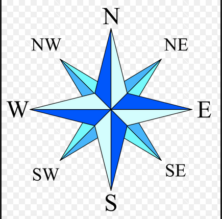
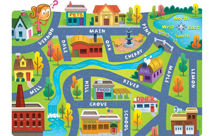
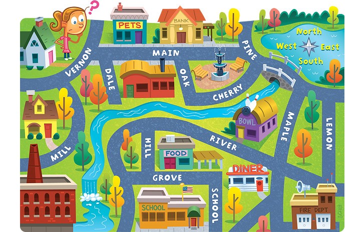
What is this?
Compass Rose.
Map Scale.
Map Legend / Key.
Antiquity
What is used to identify the symbols used on a map?
Map Title
Map Scale
Antiquities
Map Legend / Key.
OS standards for...
Ordinary Survey maps
Ordnance Survey maps
When were OS maps first drawn up?
1833
1933
Scale is the difference between your map and the distance on the ground.
True
False
Large-scale means...
a map that shows the wider area, such as mountains and hills
a map that shows more detail, such as houses and pathways
I'm not sure
Small-scale means...
A map that shows the wider area, such as mountains and hills.
A map that shows more detail, such as houses and pathways.
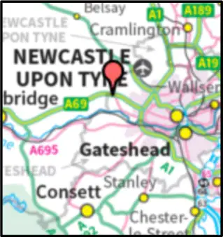
This is a...
A large-scale map.
A small-scale map.
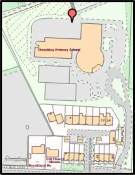
This is a...
A large-scale map.
A small-scale map.
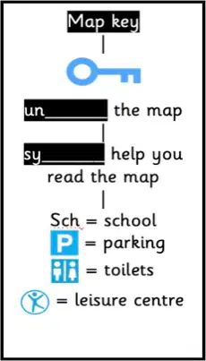
CHOOSE TWO words that are missing in the picture. Map key...
unlocks
symbols
undo
symbolise
What four things are needed to make a good map?
Title, Key, North arrow, Scale
Scale, Symbols, North Arrow, Title
North arrow, Symbols, Title, Key
Symbols, Title, North arrow, blue lines
What does OS stand for?
Original Scale
Ordinance Survey
Ordnance Survey
Optional Scale
What four things are needed to make a good map?
Title, Key, North arrow, Scale
Scale, Symbols, North Arrow, Title
North arrow, Symbols, Title, Key
Symbols, Title, North arrow, blue lines

What is this symbol?
Picnic site
Camp site
Shop
Play area

What is this symbol?
Solar panels
Viewpoint
Camp site
Farm
Scale helps us to measure what?
(a)
Which of the following does not need to be included in a good map?
Key
North arrow
Place names
Scale bar
What is missing: North, South, West
(a)
Map symbols are characters, letters, or images used on a map to indicate some place, locations or features. All map symbols need a (a) that can most often be found at the bottom of an ordnance survey map
What does 'cartographic' relate to?
The analysis of geological formations
The study of ancient civilizations
The drawing or making of maps
The study of weather patterns
What is the primary purpose of Ordnance Survey maps?
To offer travel routes
To display historical events
To provide weather forecasts
To show large areas in detail
What is a 'digital map'?
A map shown on a computer screen
A map printed on paper
A map drawn by hand
A map used for navigation at sea
What is the primary purpose of Ordnance Survey maps?
To offer travel routes
To display historical events
To provide weather forecasts
To show large areas in detail
What do OS maps use to represent physical and human features?
Color codes
Text descriptions
Symbols
Photographs
How many digits are in a four-figure grid reference?
Two
Four
Eight
Six
What is the purpose of a map key?
To indicate the map's author
To provide a map's history
To unlock a map
To show what the symbols on a map mean
What is the function of grid references on a map?
To predict weather
To calculate distances
To locate places accurately
To measure temperature
What do large-scale maps typically show?
Entire countries
Ocean currents
Global weather patterns
Individual towns and cities
What does OS stand for?
Open Survey
Ordnance Survey
Ordanance Survey
Ordenance Survey
What is another name for the legend of a map?
(a)
What is another name for the legend of a map?
(a)
What is used to identify the symbols used on a map?
Map Title
Map Scale
Antiquities
Map Legend / Key.
This informs us what a map relates to?
Map title
Map scale
Legend or key
Compass rose
A _________ is used to represent real objects on the map such as a building, road, lake, tree, mountain, etc.
Symbol
Compass Rose
Map Scale
Antiquity
What does OS stand for?
Original Scale
Ordinance Survey
Ordnance Survey
Optional Scale

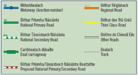
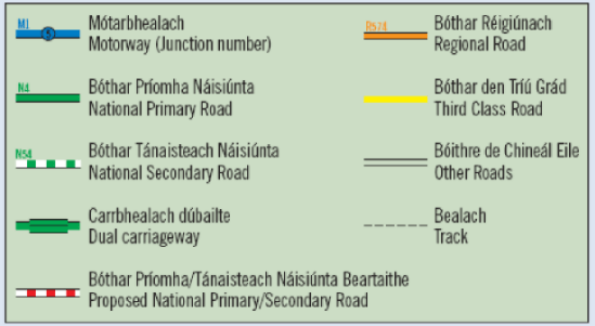
What does this symbol represent?
Dual carriageway
Footpath
Motorway
Secondary road

What does this symbol represent?
Bunkhouse
Youth hostel
Lighthouse
Place of worship

What does this symbol represent?
Picnic site
Campsite
Golf course
Public house

What does this symbol represent?
Gravel pit
Landfill
Sand pit
Other pit or quarry

What does this symbol represent?
Windmill
Wind pump
Wind turbine
Lighthouse

What does this symbol represent?
Public house
Police station
Clubhouse
Post office

What does this symbol represent?
Cycle parking
Cycle trail
Mountain bike trail
Cycle hire

What does this symbol represent?
Non-coniferous trees
Coppice
Orchard
Scrub

What does this symbol represent?
Main road
Footpath
Bridleway
Restricted byway

What does this symbol represent?
Lighthouse
Beacon
Mast
Disused lighthouse

The main compass points are:
North, West, South, East.
West, North, East, South.
North, South, East, West.
North, West, East, South.

Identify the OS Map Symbol.
Information Centre
Island
Internet Cafe

Identify the OS Map Symbol.
Parking
Post Office
Park
Peak

What does this symbol represent?
Telephone
School
Motorway
Picnic area

What does this OS map symbol represent?
Hospital
Public house
Motorway
Telephone
What does OS stand for?
Original Scale
Ordinance Survey
Ordnance Survey
Optional Scale
A distance that is measured 'as the crow flies' means...
a distance measured in a straight line
a distance measured in the air
a distance that follows all one way systems and paths
What is the center line of longitude?
Equator
Prime meridian
Longitude
latitude
What is the center line of Latitude
Prime meridian
Meridians
Latitude
Equator
A Person who makes/draws maps is
historian
geologist
archaeologist
cartographer
a map feature that explains the meaning of colors and symbols used on a map
map conents
map glossary
Map key
map index

What tool would you use to find the exact location of a place?
grid system
scale
title
legend


What is the purpose of coordinates on a map?
to show the climate of an area
to find the location of a place
to find the distance between two places
to show the meaning of symbols on a map.
GIS stands for
Geographic Information System
Generic Information System
Geological Information System
Geographic Information Sharing


What is physical geography?
Geography about humans
Geography about nature
Geography about space
Geography about PE


A compass tells us...
Direction
Distance
Temperture
Weight
A map that shows mountains, rivers, deserts, etc is called a:
political map
physical maps
thematic maps
climatic maps

What is the four digit grid reference for the car park?
4519
2044
2045
1945

What is the grid reference for point A?
345135
355345
135345
The horizontal lines in a grid are known as...
Eastings
Northings

What symbol is this?
Campsite
Level Crossing
No Entry
Picnic Area


Major cities and capital cities noted on map is called a....
Physical Map
Political Map

A map that shows physical features of the land is called a...
Physical Map
Political Map

This type of map shows landforms and bodies of water. What is it called?
Physical Map
Political Map

This map shows borders and boundaries. What is it called?
Physical Map
Political Map

These maps may be useful for pilots or mountain hikers. What is it called?
Physical Map
Political Map

This map is a...
physical map
road map
political map
thematic map

This is a...
political map
physical map
elevation map
thematic map
Something you would find on a physical map is...
a highway
a lake
a different subject
a border between states or countries
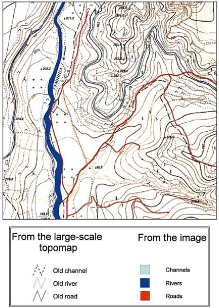
This map is an example of a . . .
Geologic Map
3D Map
Projection Map
Topographic Map
What type of map would be most helpful if you were looking for a steep trail to hike?
Geologic Map
Projection Map
3D Map
Topographic Map
Which one is a road map?


What type of map is this?
Climate
Political
Topological
Physical

What type of map is this?
Political
Road
Topological
Thematic
Which is the correct definition of a topological map?
Is also called a special-purpose, single-topic, or statistical map.
Shows countries, country borders, cities and capital cities, seas and oceans
is a type of diagram that has been simplified so that only vital information remains and unnecessary detail has been removed
What is the correct definition of a topographic map?
map is a type of diagram that has been simplified so that only vital information remains and unnecessary detail has been removed.
Refers to a detailed, graphical and accurate representation of features that appear on the Earth's surface. These geographical features can be mountains, water bodies and many more
a map showing roads especially for automobile travel.
Which is the correct definition for a climate map?
chart that shows the geographic distribution of the monthly or annual average values of climatic variables
a map, especially one designed for motorists, showing the roads of a country or area.
a map that shows countries, borders capital cities and other cities
Who is most likely to use a climate map for their job? (Check all that apply)
Scientists
Meteorologists (weather reporters)
Students
Climate activists
Who would use a topographic map? (check all that apply)
Geologists (a scientist who studies all things related to the Earth for example how it was formed and what it is made of)
Scientists
Hikers
Archaeologists (a scientist that studies human history by digging up human remains and objects)
Who might use a topographic map? (Check all that apply)
Commuters (a person who travels some distance to work on a regular basis.
Tourists
Students
Cats
What does OS stand for?
Original Scale
Ordinance Survey
Ordnance Survey
Optional Scale
The intermediate directions are...
NE, SE, NN, SS
NE, SW, NW, NS
NE, SE, SW, SE
NW, SS, SN, EE

