
 Worksheets
planning 1
Total questions: 140
Worksheet time: 2hrs 35mins
Data gathering of site conditions include the following except
Master plans and feasibility studies
Base and aerial maps, surveys
Land use plans and zoning ordinances
None of the above
Hot dry (desert-like) regions are known for the following characteristics
Water supply is extremely limited.
Drying winds are prevalent.
Often intense cold at night
All of the above
Topography pertains to the following except
Contours
Land value
Pattern of land forms
Unique land features
The final grade after all landscape development has been completed
Finished grade
Finished floor elevation
Top soil
Sub-grade
Building on level sites are favorable because
It can adapt to various building forms.
It can adapt to all street patterns.
It is economical in site development.
Appropriate for large, relatively uncomplicated grading plans and may also be used to compute volumes of water in ponds and lakes. Mostly used by landscape architects because it is most accurate.
Grading by cut
Grading by fill
Average end area method
Contour area method
Landscape elements include the following except


Inherent problems in the site may include the following except
Abnormal grading
Good drainage
Difficult street pattern
Inefficient layout
Throughout the rest of the year, the Philippines experiences the west or southwest wind and southwest monsoon which is called
Habagat
Amihan
Cyclone
Typhoons
Best suited for linear construction such as roads, paths, and utility trenching
Average end area method
Contour area method
Borrow pit method / Grid method
Grading by ut
Type of street pattern wherein the site is divided into square or rectangular blocks
Linear or ribbon
Gridiron
Geometric
Combination
Local microclimates also pertain to the following except
Wind deflection and local breeze
Heat reflection and storage
Carbon emission
For small project requiring only a limited water supply, possible sources are
Cisterns
Wells and springs
Surface impoundments (or catchments)
All of the above
Hammer, T-junction, and turn-around are examples of
Corridors
Nodes
Streets
Landscape elements
Based on Abraham Maslow's hierarchy of human needs, it is the need for affiliation and be a member of a group.
Actualization needs
Belonging needs
Esteem needs
Physiological needs
Example of Physical Form
Parks
Infrastructure
Flow of People
Services
Example of Economic Function
Water supply
Community Demands
Cultural Assets
Security
Utility is an example of
Economic Function
Physical Form
Economic Relations
Social Economics
Flow of people is an example of
Economic Function
Physical Form
Location of Different Activities
Social Impact
Water supply is an example of
Economic Function
Physical Form
Location of Different Activities
Social Impact
Churches belief are example of
Economic Function
Physical Form
Social Impact
Social Relations
Accessibility is an example of
Economic Function
Physical Form
Social Impact
Social Relations

This image is an example of
Path
District
Edge
Node

This image is an example of
Path
District
Edge
Node

This image is an example of
Path
District
Edge
Node

This image is an example of
Path
District
Edge
Node

This image is an example of
Path
District
Edge
Node
Urban planning deals with the planning of areas which constitutes both urban and rural areas.
True
False

What was the book that he published?
Mental Mapping
Image of a City
Mental Map
Image of the City
When did he published the book?
1990
1970
1960
1980
This science will take into consideration the principles man takes into account when building his settlements.
(a)

What element of a city is this?
(a)

What element of a city is this?
(a)

What element of a city is this?
(a)
(a) is the age of FLW when he died.
Were the questions easy to answer?
Yes
Super Yeees!
No
Nooo!


The World Health Organization (WHO) recommends______ minimum urban green space per person
3 square meters
9 square meters
6 square meters
12 square meters
-------- are land that is set aside for public recreation and leisure, or as parklands or for similar purposes. It includes both passive and active open space
Passive Open Space
Active Open Space
Public Open Space
Private Open Space
______ are open spaces serving a small catchment area such that users are within safe walking distance. This could be in the range of 150m to 300m, depending on the population density and the presence of barriers. Examples include parklands, gardens, plazas and civic spaces.
Small or local parks
Neighborhood Parks
Subdistrict parks
District Parks
______ are open spaces serving three neighborhoods, generally with a size of 5-6 hectares. Generally, this type of open space provides several recreation nodes offering a wide range of opportunities including sporting facilities. Passive recreation provision is important either as the primary function or to complement a sporting use.
Small or local parks
Neighborhood Parks
Subdistrict parks
District Parks
-------- are open space that is set aside for parks, gardens, linear corridors, conservation areas, nature reserves, public squares, and community gardens that are made available for passive recreation, play and unstructured physical activity.
Passive Open Space
Active Open Space
Public Open Space
Private Open Space
-------- are open spaces set aside for the primary purpose of formal outdoor sports by the community, such as city-owned basketball courts and playgrounds
Passive Open Space
Active Open Space
Public Open Space
Private Open Space
______ are open spaces serving an area generally within a walking distance of 400m to 500m from houses. The size would generally be from 0.75 to 1.00 hectare, with a minimum width of 50m to achieve a reasonably proportioned open space.
Examples include parklands, gardens, plazas and civic spaces.
Small or local parks
Neighborhood Parks
Subdistrict parks
District Parks
______ are open spaces serving the catchment including and beyond the municipality, including neighboring municipalities. The size is generally 10 to 30 hectares. This category also includes important sites of historical, cultural, or environmental significance.
Small or local parks
Neighborhood Parks
Subdistrict parks
Regional Parks
________ is land that is not suited for development purposes. It includes easements for powerlines, waterways/drainage, floodwater retention ponds, wetlands, landfill, conservation and heritage areas. This land may be used for a range of activities such as walking trails and sports fields, but this is not provided as a substitute for public open space requirements.
Encumbered land
Easement
Undeveloped land
Open Space allotment
________ refers to a “sphere of influence” of open space in terms of travel, use and its role within the open space system. Catchment can be explained using distance (eg, walkability distance), travel time, role of the site, scale, quality and level of service, and in some cases even subsequent maintenance and resourcing required for effective asset management.
Encumbered land
Easement
Undeveloped land
Catchment
Match the following:
Install landscaping that is native to your location.
Interior Design 1
Location 2
Solar Orientation 3
Use of Nature 4
Landscaping 5
Match the following:
Plan for water management-rainfall is a potential water bonanza. Large outdoor tanks can store thousands of gallons of water for use later in irrigation, or, with treatment, for drinking and cooking.
Interior Design 1
Location 2
Solar Orientation 3
Use of Nature 4
Landscaping 5
Match the following:
Building close to public transportation and bike paths, and having walking access to basic services will minimize auto use.
Interior Design 1
Location 2
Solar Orientation 3
Use of Nature 4
Landscaping 5
Match the following:
Plant drought-tolerant species of plants.
Interior Design 1
Location 2
Solar Orientation 3
Use of Nature 4
Landscaping 5
Match the following:
Trees on the east and west side of a building can reduce cooling loads.
Interior Design 1
Location 2
Solar Orientation 3
Use of Nature 4
Landscaping 5
Match the following:
Mixed use community areas of residential and commercial uses help create lively communities and reduce auto use.
Interior Design 1
Location 2
Solar Orientation 3
Use of Nature 4
Landscaping 5
Match the following:
Minimize waste by designing for standard ceiling heights and building dimensions. Avoid waste from structural over-design. Simplify building geometry.
Interior Design 1
Location 2
Solar Orientation 3
Use of Nature 4
Landscaping 5
Match the following:
Include a root cellar in your home. These keep vegetables and fruits fresh without refrigeration and increase your storage capacity.
Interior Design 1
Location 2
Solar Orientation 3
Use of Nature 4
Landscaping 5
Match the following:
Major windows should face south - but don't overdo! Too many south facing windows make rooms hot in the summer.
Interior Design 1
Location 2
Solar Orientation 3
Use of Nature 4
Landscaping 5
Match the following:
Make good use of interior space with good design- the smaller the building, the more materials, energy and money you save.
Interior Design 1
Location 2
Solar Orientation 3
Use of Nature 4
Landscaping 5
Match the following:
Rotate the orientation of the house so that south-facing walls take advantage of solar warmth during the winter.
Interior Design 1
Location 2
Solar Orientation 3
Use of Nature 4
Landscaping 5
Match the following:
Make it easy to recycle by placing recycling bins near the kitchen and adding under-sink compost receptacles.
Interior Design 1
Location 2
Solar Orientation 3
Use of Nature 4
Landscaping 5
Match the following:
Dense shrubbery can block cold winter winds or help channel cool summer breezes.
Interior Design 1
Location 2
Solar Orientation 3
Use of Nature 4
Landscaping 5
Match the following:
Plant edible landscaping for people as well as birds, butterflies, and wildlife.
Interior Design 1
Location 2
Solar Orientation 3
Use of Nature 4
Landscaping 5
Match the following:
To the north, a band of evergreens blocks the wind in winter. Toward the south, deciduous trees (those that lose their leaves in the winter) help shade the house in the summer, but let light pass through in the winter.
Interior Design 1
Location 2
Solar Orientation 3
Use of Nature 4
Landscaping 5
Match the following:
Blocking summer sun - Design roof overhangs over south facing windows so sunlight penetrates the house in the winter and is blocked in the summer.
Interior Design 1
Location 2
Solar Orientation 3
Use of Nature 4
Landscaping 5
Match the following:
Site conditions such as natural vegetation, patterns of water runoff, and the direction of prevailing winds at different times of the year have an important bearing on where the house should be sited and built.
Interior Design 1
Location 2
Solar Orientation 3
Use of Nature 4
Landscaping 5
Match the following:
Rooms that need morning light and warmth should be located in the southeast quadrant of the house; locate room used later in the day facing west, and utility areas on the north side.
Interior Design 1
Location 2
Solar Orientation 3
Use of Nature 4
Landscaping 5
Match the following:
Cluster buildings to preserve open space and wildlife habitats.
Interior Design 1
Location 2
Solar Orientation 3
Use of Nature 4
Landscaping 5
---(BLANK)-- is a key instrument for establishing long-term, sustainable frameworks for social, territorial and economic development both within and between countries. Its primary role is to enhance the integration between sectors such as housing, transport, energy and industry, and to improve national and local systems of urban and rural development, also taking into account environmental considerations
Development work
Special Planning
Spatial planning
Urban resilience
---(BLANK)-- also known as urban and regional planning, city planning, town and country planning, and/or human settlements planning, refers to the multi-disciplinary art and science of analyzing, specifying, clarifying, harmonizing, managing and regulating the use and development of land and water resources, in relation to their environs, for the development of sustainable communities and ecosystems.
Environmental Planning
Special Planning
Spatial planning
Urban resilience
---(BLANK)-- is the act of defining the allocation, utilization, development, and management of all lands within a given territory or jurisdiction according to the inherent qualities of the land itself and supportive of sustainable, economic, demographic, socio-cultural, and environmental objectives as an aid to decision-making and legislation.
Environmental Planning
Special Planning
Spatial planning
Land Use Planning
This fundamental principle of spatial planning depends very much on the form of government in which it is embedded. Good government corresponds to good planning. Spatial planning is a centrally important government function, that directly affects the lives of all people. It is therefore particularly important that planning decisions are made with legitimate authority by bodies that are accountable through democratic processes.
The democratic principle
The subsidiarity principle
The participation principle
The integration principle
This fundamental principle of spatial planning depends very much on the form of government in which it is embedded. Good government corresponds to good planning. Spatial planning is a centrally important government function, that directly affects the lives of all people. It is therefore particularly important that planning decisions are made with legitimate authority by bodies that are accountable through democratic processes.
The democratic principle
The subsidiarity principle
The participation principle
The integration principle
This fundamental principle of spatial planning takes into account that many planning issues “spill over” from one locality to another, across municipalities, regions, and even countries. In these cases, there is an argument for ceding some parts of decision-making to a higher level covering the larger area to avoid incoherent spatial development strategies. When appropriate, the decision-making process should be driven by local requirements. This principle acknowledges that it may be necessary for the decision to be made at higher levels because the scale of the issue or objective being pursued cannot properly be addressed at the local level.
The democratic principle
The subsidiarity principle
The participation principle
The integration principle
This fundamental principle of spatial planning takes into account that spatial planning plays a critical role in facilitating policy coherence and integration through territorial strategies. Integration between levels of government (jurisdictions) helps to create complementary and mutually reinforcing policies and actions. Integration across policy sectors will mutually reinforce positive benefits. Integration across administrative boundaries creates policy coherence and reduces damaging competition across larger territories.
The democratic principle
The subsidiarity principle
The participation principle
The integration principle
This fundamental principle of spatial planning takes into account that spatial planning decisions have such a wide and direct impact that opportunities to participate in those decisions should extend beyond the normal democratic process. Effective procedures for community involvement will enhance the legitimacy of policy- and decision-making by creating a sense of local ownership and ensuring consideration of citizens and property owners’ rights. The decision-making process should be transparent so that all citizens are made aware of the reasoning behind decisions. Citizens should have access to information about development proposals, plans, and policies, as well as to the officers and political committees that make such decisions.
The democratic principle
The subsidiarity principle
The participation principle
The integration principle
This fundamental principle of spatial planning takes into account that spatial planning must facilitate initiative and intuition rather than simply adhering to overly prescriptive, and possibly ineffective, measures. Spatial planning should also follow a minimalist approach, making it possible to prioritize the issues that need most urgent attention.
The democratic principle
The subsidiarity principle
The participation principle
The proportionality principle
This fundamental principle of spatial planning indicates that where the potential damage caused by any development activity is serious or irreversible, the lack of certainty about impacts should not be used as a reason for inappropriate policy decisions or the failure to take corrective action.
The precautionary principle
The subsidiarity principle
The participation principle
The proportionality principle
The arrangement and design of buildings, public spaces, transport systems, services, and amenities.
Urban Planning
Settlements
Urban Design
Planning
•the control of the use of land and design of the urban environment, including transportation networks, to guide and ensure the orderly development of settlements and communities.
Urban Design
Urban Planning
City Design
Urban Sprawl
Chandigarh city was designed by
B V Doshi
Charles Correa
Edwin Lutyens
Le Corbuiser
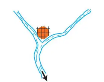
Identify the type of settlement
Bridge point
Head of navigation
Confluence
Portage
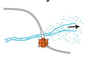
Identify the type of settlement
Bridge point
Head of navigation
Confluence
Portage
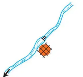
Identify the type of settlement
Bridge point
Head of navigation
Confluence
Portage
•Types of the settlements are determined by the extent of the built-up area and inter-house distance.
True
False
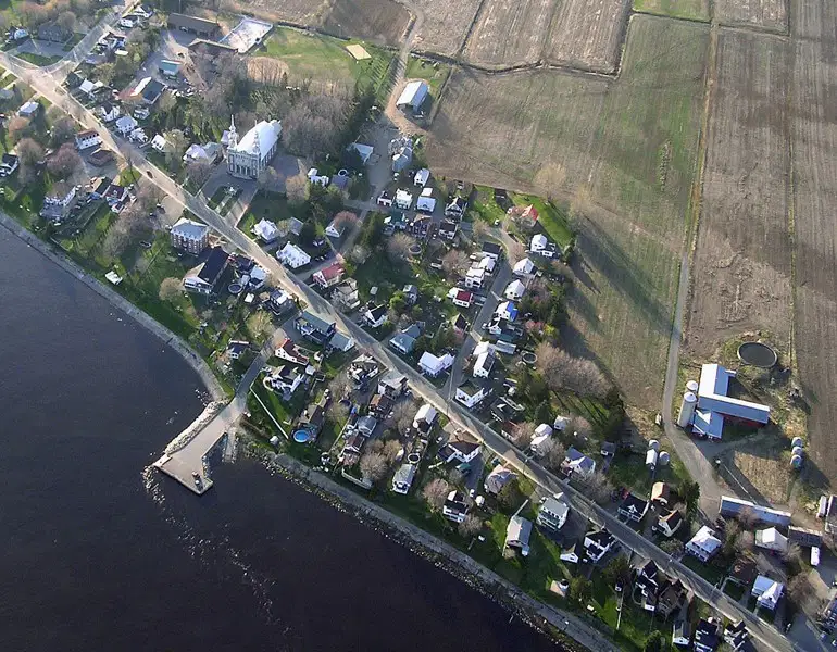
Identify the pattern of Settlements
Circular
Clustered
Linear
Fan Shaped
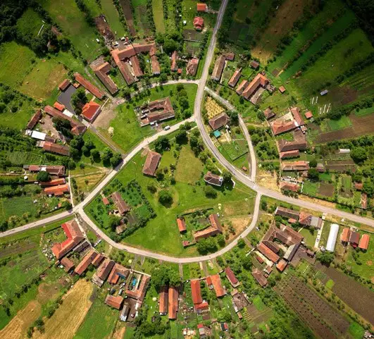
Identify the pattern of Settlements
Circular
Clustered
Linear
Fan Shaped
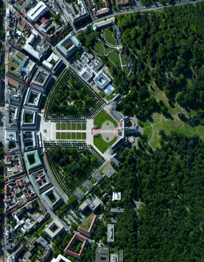
Identify the pattern of Settlements
Circular
Clustered
Linear
Fan Shaped
A ------- is a general term used in archaeology, geography, landscape history, and other subjects for a permanent or temporary community in which people live, without being specific as to size, population, or importance.
settlement
conurbation
ekistics
village
______ Settlement grows by natural accretion around its source of life – usually a body of water, food basket, or locus of commerce
Human adaptation gives settlement its “shape and pattern”
Dentritic
Planned
Unplanned
Ordered
______ settlement is purposively designed with identifiable core, nodes, transport network, and edges.
Might be a result of royal decree during colonial period, or a statute from modern legislature, or thorough re-planning by a specialist commissioned by local government.
Dentritic
Planned
Unplanned
Ordered
The development of _____ influenced the division of land into separately owned plots aided by the plow which achieved the rectilinear plots guided by the “square measure”
central government
Music
Nomadic settlements
Agriculture
The converging routes and the later roads marking the lines of successive city walls together may produce a plan resembling a spider’s web, and it is to the Middle Ages that some authorities ascribe the first use of the _____ still typical of many European cities
linear plan
radial-concentric plan
gridiron plan
open plan
______ became the first template to design the conquest and layout of Spain's territories in the Americas and the Philippines. In the establishment of mission settlements by the Spanish religious, spatial choices, and organization, the code dictated the location of new settlements that later on became town nuclei, the apportionment of land to Spain's loyal soldiers, the church-plaza centric arrangement, and the humane manner by which the conquerors should treat the natives.
Haciendas
Realengas
Recopilación de las leyes de los reinos de Indias
Reducción bajo la campana
______ literally meaning "reduction under the church bells," the reducción became the seed from which villages and later towns evolved and developed, under the watch and supervision of Spain's religious missionaries. The religious gathered the natives in a doctrina or religious mission and, thus, from there preached the Christian doctrine.
Haciendas
Realengas
Recopilación de las leyes de los reinos de Indias
Reducción bajo la campana
The______ mirrored the provisions of the Laws of the Indies, which served as the planning backbone for the first centuries of conquest, pacification and reduction under the fold of Christianity and the protection of the Spanish Crown. Emerging as political units, this arrangement reflects the social stratification prevalent in the period.
Plaza Complex planning model
Realengas
Recopilación de las leyes de los reinos de Indias
Reducción bajo la campana
______ are watershed events that triggered the genesis of American sanitary order in the Philippines in which American colonial therapeutics justified the use of force in the aggressive overhaul of the physical urban space and the native practices that occurred within its domain.
Bubonic Plague and Spanish Flu
Malaria and Bubonic Plague
Cholera and Malaria
Bubonic Plague and Cholera
______ was issued on November 20, 1943 instructing the cultivation of all available lands for the production of food crops. Thiswas prompted by food shortage and an unprecedented rise in essential commodities. The ordinance, which was a reiteration of Executive Order No. 40 signed by Vargas in May 14, 1942, led to the unregulated slash-and-burn agriculture and the destruction of many forest areas.
Executive Order No. 110
Ordinance No. 4
Urban Farming Act
Food Security Proclamation
This process selects from a list of potential sites on that suits best in the given use and requirements of the project.
Development Sustainability Process
Site Selection Process
Site Planning
Site Analysis
This process selects the best possible use and development suited for a given site.
Development Sustainability Process
Site Selection Process
Site Planning
Site Analysis
It is the branch of geology that deals with the origin, nature and distribution of landforms.
Physiography
Hydrology
Topography
Geomorphology
A detailed description or representation on a map of the natural and artificial features of an area.
Topography
Geomophology
Physiography
Topographic Map
The natural science that
studies the waters of the earth, their
occurrence, circulation and distribution, their
chemical and physical properties, and their
reaction to the living environment including
their relation to all living things.
Topography
Geology
Hydrology
Physiography
A permeable geological stratum or formation that can both
store and transit groundwater in significant quantities.
Water Table
Aquifier
Watershed
A geographic area of land bounded by topographic
features and height of land that captures precipitation, filters and stores water and drains water to a shared designation.
Water Table
Aquifier
Watershed
It influences the privacy, social contact among people, and freedom of movement of an individual or a group of people.
Density
Zoning
Transit System
Utilities
The study of the community and its social and economic structures are done to determine whether there is a need, an interest, or any objections on the project.
Traffic and Transit System
Historic Factors
Socio-Economic Factors
Density and Zoning
It is defined as the way an open space of a given site is configured to an arrangement of elements that evoke activity or flow, both physically or visually
Spatial Pattern
Natural Feature
Visual Resource
When sites are characterized by
outstanding natural features of earth
rock, water or plant material, these
may be incorporated in the site
development as natural assets of the
land.
Natural Feature
Spatial Pattern
Visual Resource
It is a confined
view usually directed
toward a terminal or a
dominant feature.
View
Vista
Foreground
View Station
The vehicular and pedestrian circulation on or adjacent to site.
Traffic and Transit System
Density and Zoning
Existing Land Use
Utilities
These are present, along with laws and codes, in every city and municipality to regulate the type of development. It divides into land-use that are designated by building height, building coverage, density of population and open spaces.
Density and Zoning
Zoning Regulations
Utilities
The art of arranging structures on the land and shaping
the spaces between; an art linked to architecture,
engineering, landscape and city planning.
Site Analysis
Site Planning
Site Selection Process
Site Development
Defines a project's scope, objectives, purpose and deliverables:
Project Initiation
Site Selection and Programming
Site Inventory
Site Analysis
Considered as the slope's orientation, influencing the site's microclimate by affecting the amount of solar radiation striking the surface.
Topography
Elevation
Contour
Aspect
The shape of development exhibited by the settlements of the Meso-American civilizations as well as the Mesopotamian civilizations.
Linear
Grid pattern
Radiocentric
Satellite
Precursor to linear cities.
Une Cite Industrielle
Babylon
Huang He Valley Civilization
Classical Towns
One of the earlier influences on sustainable developments stemmed from the work of Paolo Soleri. How did he translate his concept of sustainable planning?
Floating City
Ciudad Lineal
Self-contained environments
Roadtown
A growing concern of urbanization, resulting to congestion of cities.
Slums
Urban chaos
Land valuation
Urban growth
What is the shape of development that encourages cooperation?
Linear
Rectilinear
Radiocentric
Sheet
According to Ferdinand Tonnies, it is a community type that describes an association in which individual's self-interest takes precedence over the larger association.
socialist
communist
gesellschaft
gemeinschaft
In James Vance's urban model, he explains that the urban realm is a natural function of the growth of cities and suggested this term to describe the basic unit of an extended metropolis.
sympolis
edge city
megalopolis
neighborhood
Gentrification in cities could result to the following:
decentralization of commercial functions
increase in crime rates
displacement of the poor
decrease of the property value
Issues such as slums, crimes, homelessness, traffic congestion, urban sprawl, among many, result from the continuous population growth of cities. These cities with very large population are referred to as:
edge cities
megacities
acropolis
exurbs
A form of living street (woonerf) that helps manage the vehicular traffic to provide safer conditions for communities:
channelization
clover leaf
diamond
footbridge
A development type characterized by a mixed-use residential and commercial area designed to maximize access to public transport and encourage transit ridership:
Traditional neighborhood
Neighborhood unit
Planned unit development
Transit-oriented development
A popular movement which claimed that design could not be separated from social issues and should encourage civic pride and engagement. Most new capital cities adopted this planning approach including the master plan for the capitol city of Quezon in 1941.
Garden City
New Urbanism
City Beautiful Movement
Modernist Movement
Considered as one of the first industrialized districts in Manila.
Binondo
Pandacan
Malate
Ermita

