
 Worksheets
SCIENCE 7 - 4Q W1-W4
Total questions: 139
Worksheet time: 3hrs 52mins
It is a fracture in the Earth's crust through which movement has occurred. (a)
It is a sudden and violent shaking of the ground caused by the movement of the tectonic plates beneath the earth. It can occur on land or under the ocean. (b)
The side of a non-vertical fault that occurs above the fault plane. (c)
The side of a non-vertical fault that can be found below the fault plane. (d)
Also referred to as seismicity, is the occurrence and distribution of earthquakes in a region. (e)
The Pacific Ring of Fire covers a chain of shoreline countries around the Atlantic Ocean. (a)
The Pacific Ring of Fire is where wildfire often occurs. (b)
The movement of the ground is responsible for the geological activities on the Pacific Ring of Fire. (c)
The Pacific Ring of Fire dominates the Pacific Ocean with at least 450 dormant and active volcanoes, forming a horseshoe. (d)
There are a lot of volcanoes in the Pacific Ring of Fire because of the movement, collision, and destruction of lithospheric plates. (e)
Match the following type of fault

normal fault

reverse faults (trust faults)

strike-slip faults
Match the following type of fault
Inclined at an angle less than
45 degrees from the horizontal.
Vertical motion where the
hanging wall moves downward relative to the
footwall.
This type of faulting occurs in extensional
tectonic settings, such as divergent plate
boundaries.
Inclined at an angle greater than
45 degrees from the horizontal.
Vertical motion where the hanging
wall moves upward relative to the footwall.
Reverse
faults typically form in compressional tectonic
settings such as convergent plate boundary
Nearly vertical, with minimal
inclination from the horizontal.
Horizontal motion where the
movement is predominantly lateral along the fault
plane.
common in transform plate boundaries where two tectonic plates slide past each other
horizontally
NORMAL FAULT
Forms in areas undergoing (a) tectonic stress, where the Earth's crust is being pulled apart (divergent movement) forming (b) . As the hanging wall moves (c) relative to the footwall, (d) stress builds up along the fault plane. Eventually, the accumulated stress exceeds the strength of the rocks, causing them to (e) energy in the form of seismic waves.
REVERSE FAULTS (THRUST FAULTS)
Reverse faults form in areas undergoing (a) tectonic stress, where the Earth's crust is being pushed together. As the hanging wall moves (b) relative to the footwall, (c) stress builds up along the fault plane. When the
accumulated stress exceeds the strength of the rocks, they break along
the fault, releasing (d) energy as seismic waves.
STRIKE-SLIP FAULTS
Strike-slip faults form in areas undergoing (a) tectonic stress, where the Earth's crust is moving (b) past each other. Stress builds up along the fault plane due to the (c) between the moving plates. When the frictional (d) is overcome, the rocks on either side of the fault suddenly (e) past each other, releasing energy in the form of seismic waves.
Forms in areas undergoing compressional tectonic stress, where the Earth's crust is being pushed together. (a)
Forms in areas undergoing extensional tectonic stress, where the Earth's crust is being pulled apart (divergent movement) forming valleys. (b)
Form form in areas undergoing lateral tectonic stress, where the Earth's crust is moving horizontally past each other. (c)
In the Philippines, the most common types of faults are typically (a) . The country is located along the (b) of the Philippine Sea Plate and the Eurasian Plate, where the movement is (c) (strike-slip) and (d) (thrust). These types of faults are responsible for the significant seismic activity and (e) experienced in the region.
(a) is a transform boundary formed by the movement of the Philippine Sea Plate and the Eurasian Plate.
The (b) is the most active fault line in the Philippines.
(c) are structures where we expect displacement to
occur. Because a shallow earthquake is a mechanism that causes displacement across a fault, they must all occur on active faults.
(d) are features that we can recognize but do not produce earthquakes.
The fault plane is inclined at an angle greater than 45 degrees from the horizontal, and the hanging wall moves upward relative to the footwall. (a)
The fault plane is nearly vertical, and the movement is predominantly lateral along
the fault plane. (b)
The fault plane is inclined at an angle less than 45 degrees from the horizontal, and the hanging wall moves downward relative to the footwall. (c)
Direction of Slip: Horizontal motion, where two tectonic plates slide past each other horizontally - (a)
Direction of Slip: Vertical motion, where hanging wall moves downward relative to the footwall that occurs from tensional tectonic settings. - (b)
Direction of Slip: Vertical motion, where hanging wall moves upward relative to the footwall that typically form in compressional tectonic settings. (c)
Match the following
The point within Earth where rock under stress breaks, resulting in
an earthquake.
FOCUS
The point on the Earth's surface that is directly above the focus.
EPICENTER
Earthquake magnitude is a measure of the “size,” or amplitude,
of the seismic waves generated by an earthquake source and recorded by
seismographs (instrument that makes a record of seismic waves caused by an
earthquake, explosion, or other Earth-shaking phenomenon).
MAGNITUDE.
It is a measure of the strength of shaking experienced in an
earthquake.
INTENSITY
The vibration generated by an earthquake, explosion, or
similar energetic source and propagated within the earth or along its surface.
SEISMIC WAVE
NAME THE FOLLOWING PARTS
Which of the following best describes the epicenter of an earthquake?
The point on the Earth's surface directly above the focus.
The deepest point within the Earth where the seismic energy is released.
The point within the Earth where the fault rupture begins.
The area where the ground shaking is most intense.
What is the primary factor that determines the magnitude of an earthquake?
The depth of the earthquake's focus.
The distance from the epicenter to the affected area.
The amount of energy released by the seismic event.
The amount of energy released by the seismic event.
How does earthquake intensity differ from earthquake magnitude?
Magnitude measures the energy released, while intensity measures the
damage caused.
Magnitude measures the depth of the focus, while intensity measures the
distance from the epicenter.
Magnitude measures the depth of the focus, while intensity measures the
distance from the epicenter.
Magnitude measures the area affected, while intensity measures the
frequency of aftershocks.
Which of the following is a potential effect of an earthquake on a community?
Increased rainfall and flooding.
Growth of vegetation and wildlife.
Displacement of tectonic plates.
Damage to buildings, infrastructure, and loss of life.
What role does the focus of an earthquake play in determining its effects on
the Earth's surface?
The deeper the focus, the more severe the ground shaking.
The shallower the focus, the greater the potential for tsunamis.
The focus determines the direction of the seismic waves.
The focus has no direct impact on the effects of the earthquake.
The (a) are caused by the sudden release of energy stored in the Earth's crust.
When tectonic plates shift or collide, seismic waves are generated, spreading outward from the point of origin, called the (b) .
The higher the (c) of an earthquake, the greater the potential for widespread damage and devastation in the affected community.
In some cases, these earthquakes occur underwater, along subduction zones, where one tectonic plate is forced beneath another. This movement can displace large volumes of water, resulting in the formation of a (d) .
Match the following
is a series of ocean
waves that sends surges of
water, sometimes reaching
heights of over 100 feet (30.5
meters), onto land.
TSUNAMI
These are
body waves, which move into
the Earth's core at a greater
frequency than surface waves.
BODY WAVES
Surface
waves are similar to
transverse waves, except they
flow over the Earth's surface-
air boundary, or through the
crust.
SURFACE WAVES
Refers to the large
amount of water that a
tsunami pushes onto the
shore above the regular sea
level.
RUN-UP
is the result of
a tsunami traveling a long
distance inland and is a
horizontal measurement of
the path of the tsunami.
INUNDATION.
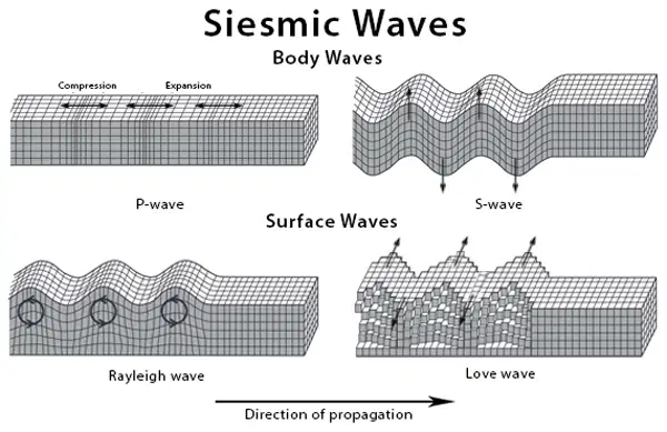
The motion of (a) particles forms a horizontal line that is perpendicular to the propagation direction. The energy of Love waves radiates in two directions rather than three.
(b) are compressional waves that travel through solids, liquids, and gases.
The motion of (c) is a mix of longitudinal, compressional, and dilatation.
_ (d) : They are also known as shear waves, and they can only propagate in hard, solid materials by vibrating particles in a direction perpendicular to the propagation.
They are easily identified and are responsible for earthquake-
related damage and devastation. (a)
travel through the interior of the Earth and have a frequency higher than the surface wave. - (b)
are waves that flow along the Earth's surface-air boundary, or into the crust. They have lower frequency than body waves. - (c)
have particles that move in a circular or elliptical pattern. (d)
TYPES OF SEISMIC WAVES
P-waves
S-waves
Rayleigh waves
Love Waves
BODY WAVES
also known as pressure waves, may
travel through both solid and liquid materials
move
quickly and are the first to reach the seismograph
propagate through a substance by compressing and expanding
it alternately
particles' velocity is parallel to the direction of
wave transmission
also known as shear
waves
only propagate in gard solid materials by vibratibng particles in direction perpendicular
cannot spread across a liquid
Seismologists could verify the existence of a liquid outer core of
the Earth
(a) – are waves that flow along the Earth's surface-air boundary, or into the crust. They have (b) frequency than body waves. They are easily identified and are responsible for (c) - related damage and devastation. Surface waves have particles that move in a (d) pattern. The strength of surface waves (e) as they go deeper below the surface.
SURFACE WAVES
named after the British scientist Lord
Rayleigh, who predicted their existence
their motion is a mix of
longitudinal, compressional, and dilatation
as a result, the
particles travel elliptically in the vertical plane
are
dispersive, and their amplitudes often decline exponentially
with depth in the earth
named after British mathematician A. E. H. Love
particles of Love waves jerk back and forth
perpendicular to the direction of wave transmission
particles forms a horizontal
line that is perpendicular to the propagation direction
radiates in two directions rather than
three
move quicker than Rayleigh waves
amplitude often diminishes significantly with depth
describe the motion of the slinky for each wave type.
Hold one end of the slinky and shake it side to side
horizontally.
S-wave
Hold one end of the slinky and quickly push and pull it
back and forth horizontally.
P-wave
Push the slinky horizontally along its length, causing it to
compress and stretch sideways.
Love wave
Hold one end of the slinky firmly in place. Using your other
hand, move the end of the slinky up and down vertically while also
moving it side to side horizontally in a circular motion.
Rayleigh wave
Which of the following statements best describes the motion of Love waves
during an earthquake?
Love waves travel in a rolling motion parallel to the direction of wave
propagation.
Love waves travel in a rolling motion perpendicular to the direction of
wave propagation.
Love waves travel in a compressional motion perpendicular to the
direction of wave propagation.
Love waves travel in a compressional motion parallel to the direction of
wave propagation.
How do earthquakes occurring underwater or along subduction zones
contribute to the formation of tsunamis?
Underwater earthquakes release energy that generates seismic waves,
which propagate through the water and create tsunami waves.
Subduction zone earthquakes cause the sudden uplift of the seafloor,
displacing water and generating tsunami waves.
Underwater earthquakes trigger volcanic eruptions, leading to the
formation of tsunamis.
Subduction zone earthquakes cause the release of toxic gases, resulting in
the formation of tsunamis.
What is the primary factor that determines the extent of devastation caused
by tsunamis on shoreline communities?
The magnitude of the earthquake that triggered the tsunami.
The frequency of tsunami events in the region.
The proximity of the shoreline community to the earthquake epicenter.
The presence of advanced warning systems in the affected area.
In what way do surface waves contribute to the destructive power of
tsunamis?
Surface waves propagate quickly through the water, causing widespread
flooding.
Surface waves generate strong winds that intensify the impact of tsunamis
on shoreline communities.
Surface waves interact with the seafloor, creating additional energy and
increasing the height of tsunami waves.
Surface waves carry debris and sediment, exacerbating the damage
caused by the initial wave impact.
How can coastal communities mitigate the impact of tsunamis on their
shoreline infrastructure?
By constructing seawalls and levees to absorb the energy of tsunami
waves.
By encouraging residents to build homes closer to the coastline for easier
evacuation during tsunamis.
By relying solely on early warning systems to evacuate residents before the
arrival of a tsunami.
By conducting regular drills and exercises to test emergency response
plans.
Match the following
It refers to a series of ocean waves that sends surges of water,
sometimes reaching heights of over 100 feet (30.5 meters), onto land.
tsunami
The motion of this type of wave has particles that forms a horizontal
line that is perpendicular to the propagation direction. The energy of
Love waves radiates in two directions rather than three.
love wave
This type of waves are compressional waves that travel through solids,
liquids, and gases. They propagate through a substance by
compressing and expanding it alternately.
P-waves
The motion of this type of wave is a mix of longitudinal, compressional,
and dilatation. As a result, the particles travel elliptically in the
vertical plane.
Rayleigh wave
They are also known as shear waves, and they can only propagate in
hard, solid materials by vibrating particles in a direction perpendicular
to the propagation.
S-waves
Match the following
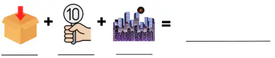
intensity

warning
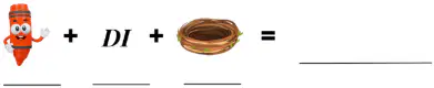
readiness

evacuate

simulate
Match the following
is a measure of the strength of shaking experienced in an
earthquake.
intensity
a statement or event that indicates a possible or impending
danger, problem, or other unpleasant situation
warning
the state of being fully prepared for something:
readiness
remove (someone) from a place of danger to a safer place
evacuate
to produce a situation or event that seems real but is not
real, especially in order to help people learn how to deal with such
situations or events.
simulate
Which of the following statements best describes the purpose of intensity
scales in assessing earthquake effects?
Intensity scales measure the depth of an earthquake's epicenter.
Intensity scales quantify the energy released by an earthquake.
Intensity scales evaluate the effects of an earthquake on people, structures,
and the environment.
Intensity scales determine the duration of shaking during an earthquake.
How does the Modified Mercalli Scale differ from the Richter Scale?
The Modified Mercalli Scale measures earthquake magnitude, while the
Richter Scale measures earthquake intensity.
The Modified Mercalli Scale measures earthquake depth, while the Richter
Scale measures earthquake duration.
The Modified Mercalli Scale measures earthquake effects, while the Richter
Scale measures ground shaking.
The Modified Mercalli Scale measures earthquake frequency, while the
Richter Scale measures earthquake location.
During an earthquake, what is the most appropriate action to take if you are
indoors?
Stay inside and hide under a sturdy piece of furniture.
Run outside and seek open space immediately.
Stand in a doorway to prevent door collapse.
Turn off all utilities and evacuate the building.
Which of the following items should be included in an earthquake
preparedness kit?
Matches and candles for lighting.
A battery-operated radio and extra batteries.
Bottled water and non-perishable food items.
All of the above.
What is the primary goal of tsunami evacuation procedures?
To gather belongings and secure valuables.
To seek high ground or move inland to avoid tsunami waves.
To stay inside buildings and wait for rescue.
To drive to the coast and observe the tsunami.
Match the following
a stress that squeezes rocks together resulting from forces applied perpendicular to a fault plane
compression
a block of crust that lies beneath the fault plane
hanging wall
the point within the Earth's crust where an earthquake begins
hypocenter
the point on the Earth's surface vertically above the hypocenter
epicenter
the shaking or vibration of the ground surface in response to the sudden release of energy caused by fault movement
earthquake
Match the following
commonly termed the focus
hypocenter
a fracture in the Earth's crust where one side moves relative to the other
fault
the flat (planar) surface along which there is movement during an earthquake
fault plane
a block of crust that is located above the fault plane
foot wall
a fracture in the Earth's crust where the hanging wall moves relative to the foot wall
normal fault
Match the following
a fracture in the Earth's crust where the hanging wall moves up relative to the foot wall
reverse fault
a stress that moves rock in opposite directions resulting from forces applied parallel to a fault plane
shear
a fracture in the Earth's crust where two blocks of crust move laterally relative to one another
strike-slip fault
the rigid, thin, irregularly-shaped slabs of solid rock that move relative to one another on the outer surface of the Earth
tectonic plates
a stress that pulls rocks apart resulting from forces applied perpendicular to fault plane
tension
Match the following
a fracture in the rocks that make up the Earth's crust
fault
the point at the surface of the Earth directly above the focus
epicenter
the point within the earth
focus (hypocenter)
massive rocks that make uo the outer layer of the earth's surface, and whose movement along faults trigger earthquakes
plates
waves that transit the energy release by an earthquake
seismic waves
When the btreak line ( the (a) ) between two blocks of rock suddenly moves, the movement causes vibrations ( (b) ) to race rapidly outward in all directions from the (c) . The point at ground level directly above the focus is called the (d) .
(a) - is where the action is. It is a flat surface that may be vertical or sloping (b) - is the line it makes on the Earth's surface
(c) - The overhanging face of a fault found resting on top of the foot wall (d) - The ramp-like face of a fault found underneath the hanging wall.
(e) - the place where fault ruptures begin
Epicenter - is the point on the Earth's surface directly above a hypocenter or focus the point where an earthquake or an underground explosion originates
(a) - The block of rock that forms the lower half of a fault. always below the fault line.
(b) - The block of rock that forms the upper half of a fault. Always above the fault line.
(c) occur due to tensional stress.
(d) forms under compressional forces.
(e) occurs when rocks move horizontally or slide past each other.
areas along which all shallow earthquakes occur. Display seismic activity within 10,000 years - (a)
areas which had not displayed any seismic activity for more than 10,000 years - (b)
Which scale estimates the total energy released by an earthquake?
Seismogram
Seismograph
Richter scale
PHIVOLCS Earthquake Intensity Scale
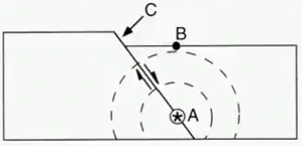
What is point A in the illustration?
Epicenter
Fault
Focus
Seismic wave
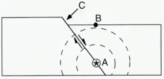
What is point B in the illustration?
Epicenter
Fault
Focus
Seismic wave
An earthquake can be described by two key concepts: Intensity and Magnitude. Which of the following statements best explains the difference between them?
Intensity refers to the total energy released by the earthquake, while magnitude measures the shaking felt at different locations.
Intensity measures the effects of the earthquake, such as damage and shaking experienced, while magnitude measures the size of the earthquake based on the energy released.
Intensity is the measure of the earthquake's speed, while magnitude describes how long the earthquake lasts.
Intensity is used to predict the damage caused by an earthquake, while magnitude predicts how far seismic waves will travel.
Tsunamis are large ocean waves typically caused by underwater earthquakes. Which of the following statements best explains why tsunamis are more dangerous than regular ocean waves.
Tsunamis are caused by volcanic eruptions, which makes them more destructive than regular ocean waves.
Tsunamis travel at higher speeds than regular waves and have much longer wavelengths, allowing them to reach coastal areas faster and with greater impact.
Tsunamis are generated by storms, which cause them to have a stronger force than regular ocean waves.
Tsunamis are caused by the gravitational pull of the moon, making them more predictable and less dangerous than regular ocean waves.
The rocks beneath the Erath's surface are constantly subjected to (a) caused by pushing and pulling forces.
When the rigid rocks break, the energy stored in hem is released and energy is manifested on the Earth's surface as (b)
The energy that causes earthquakes travels from particles to particle in the solid and liquid materials of the Earth. This energy spreads through the Earth as vibrations called (c) .
Seismic waves radiate from the (d) of an earthquake.
The point of origin of the seismic wavers is called the (e) .
The (a) is located on the Earth's surface directly above the focus.
The (b) refers to the perceptible strength of an earthquake in a certain locality or area.
Intensity describes the effects, or the amount of damage (c) has caused on people, infrastructure, natural objects, and land surfaces,
A quantitative measure of an earthquake's strength is called (d) .
Magnitude refers to the amount of energy released. This is determined from the amplitude of the surface waves recorded by a (e) .
Match the following
is the recording of the ground shaking at he specific location of the instrument
seismogram
refers to the quantitative measure for earthquake magnitude
Richter Scale
refers to the amount of energy released
magnitude
determined from the amplitude of he surface waves recorded by a ___
seismometer
describes the effects, or the amount of damage earthquakes has caused on people, infrastructure, natural objects, and land surfaces
intensity
Magnitude and Intensity
qualitative assessment of the kinds of damage done by an earthquake
quantitative measurement of the amount of energy released by an earthquake by modern seismograph
depends on distance to earthquake & strength of earthquake
depends on the size of the fault that breaks
determined from the intensity of shake and damage from the earthquake
determined from seismic Records
A Japanese term used to describe a series of ocean waves generated by the displacement of water due to underwater earthquakes or volcanic eruptions - (a)
The energy of (b) earthquake is equivalent to about 6,270,000 tons of TNT explosives.
During the tsunami, the tectonic plates of the Earth's surface slip releeasing a masive amount of energy into the (c) .
Tsunami is moving at overr (d) per hour.
A tsunami is formed as the displaced water moves under the influence of (e) .
How are tsunami formed?
(a) under the ocean, submarine landslides ir landslides in the mountains carrying a big volume of debris to the ocean.
(b) plunging into the ocean
(c) movement associated with earthquakes, landslides, lava entering the sea, seamount collapse
How does the energy from the sun reach the Earth?
On average, it takes approximately (a) or 500 seconds for solar energy to reach the top of Earth's (b) . Covering an approximate distance of (c) through space, this energy reaches the top layer of Earth's atmosphere. The (d) propagates in waves from the Sun, traveling at the speed of light as (e) within the vacuum of space.
The Earth's (a) causes day and night, while its (b) around the Sun brings about the changing (c) throughout the year.
Analyze the illustration and label the parts.
Analyze the statement refers to either Earth’s Rotation or Revolution.
The Earth is turning on its
axis.
Approximately 23 hours, 56
minutes, and 4 seconds or
24 hours.
Creates the diurnal cycle of
lightness and darkness.
The movement of the Earth
around the Sun
Approximately 365.25 days.
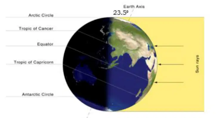
The angle of Earth's axial tilt is (a) .
in the diagram, the Tropic of Cancer and the equatorial region receive the greatest intensity of the (b) . Sunlight strikes the (c) more directly compared to other (d) . This direct angle of sunlight results in greater heating and higher (e)
As you move from the equator towards the poles, sunlight strikes the Earth's surface at an increasingly (a) angle. This means the same amount of (b) is spread over a larger area, resulting in less intense heating.
Near the poles , sunlight strikes the Earth's surface at a very oblique angle, especially during (c) months. This results in less (d) being absorbed, leading to colder temperatures. These regions also have reduced duration of sunlight leading to less (e) being received
Near the (a) , sunlight strikes
the Earth's surface almost
perpendicularly throughout the
year. This (b) of sunlight
leads to maximum heating and
results in (c) .
Earth’s Tilt Cloze The tilt of the Earth's axis relative to its orbit around the Sun contributes to the changing seasons. Regions near the 1) (a) experience higher temperatures because sunlight strikes the Earth's surface more 2) (b) resulting in greater heating. Near the equator, sunlight strikes the Earth's surface more 3) (c) leading to higher intensity of solar radiation and heat. The tilt of the Earth's axis causes different parts of the Earth to receive varying amounts of 4) (d) throughout the year, leading to the changing seasons. The angle at which sunlight strikes the Earth's surface near the equator and near the poles affects the 5) (e) of solar radiation and heat received. Temperatures vary by latitude, with locations closer
The earth makes one complete rotation approximately once every (a) . As one side of the earth rotates toward the sun, that side experiences (b) . The side facing away from the sun experiences (c) .
Earth’s axis is tilted (d) in the same direction, so the parts of Earth that receive more direct sunlight and have more daylight hours change throughout the year. This causes (e) or times of the year with patterns of weather and daylight, which vary depending on where you live.
The seasons change due to the (a) of the Earth's axis as it orbits around the Sun. Throughout the year, different parts of the Earth receive varying amounts of _ (b) because of this tilt.
When a particular hemisphere is tilted towards the Sun, it receives more direct sunlight, leading to (c) . When that hemisphere is tilted away from the Sun, it receives less direct sunlight, resulting in (d) .
The changing (a) of sunlight and the varying (b) of daylight hours throughout the year contribute to the (c) .
The (d) are characterized by equal lengths of day and night,
while (e) are characterized by the longest or shortest days of the year.
What causes the sun to appear as it rises in the east and sets in the west?
revolution
revolution
tilt of the earth
earth’s gravitation
Which day in the northern hemisphere has the fewest hours of daylight?
winter solstice
vernal equinox
summer solstice
autumnal equinox
Which statement is TRUE if you are living near the equator?
A nighttime all year long.
A longer daylight all year long
A shorter daylight all year long.
An equal hour of daylight all year long
What causes the Sun's apparent path across the sky during the day?
Earth's tilt
Earth's rotation
Earth's revolution
Earth's magnetic field
Which best explains why winter is colder than summer?
Earth is closer to the sun during winter.
Earth rotates on its axis slower during winter.
Earth’s rotation causes more wind to blow during winter.
Earth’s tilt allows less energy to be received during winter.
Why is it summer in the southern hemisphere if the northern hemisphere is
experiencing winter?
The southern hemisphere is nearest to the sun
The southern hemisphere is balancing the temperature of the earth.
The southern hemisphere is on a path of warm winds from the north.
The southern hemisphere is receiving the most direct rays from the sun.
In January, what would be the season in the southern hemisphere and
northern hemisphere respectively?winter and summer
winter and summer
summer and winter
both experiences summer
both experiences winter
What season occurs in the northern hemisphere if the axis is pointed away
from the sun?
fall
spring
summer
winter
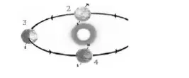
What season is experienced in the northern hemisphere at position 2?
fall
spring
summer
winter
What is the season north of the equator if the north pole is tilted towards the
sun?
fall
spring
summer
winter
What is the cause of the earth’s season?
variation in the amount of energy given off by the sun
earth’s elliptical orbit and varying speed of revolution
earth’s greatest distance from the sun during winter
inclination of the earth’s axis and revolution around the sun
How does the tilt of the Earth's axis affect the length of daylight hours at
different latitudes?
It has no effect on daylight hours.
It results in longer daylight hours near the poles.
It causes daylight hours to vary with the seasons
It causes daylight hours to remain constant throughout the year.
How does the tilt of the Earth's axis contribute to the changing seasons?
By changing the Earth's distance from the Sun
By causing variations in the Earth's orbital speed
By creating differences in the intensity of solar radiation
By altering the angle of sunlight reaching different latitudes
Which of the following statements about the summer solstice is true?
It marks the beginning of autumn.
It marks the shortest day of the year.
It occurs when the Earth's axis is tilted towards the Sun
It occurs when the Earth's axis is tilted away from the Sun.
Which factor primarily determines the length of daylight hours during a
particular season?
Earth's rotation speed
Earth's distance from the Sun
Earth's atmospheric composition
Earth's tilt relative to its orbit around the Sun
(a) is the point in an orbit where a celestial body is closest to the Sun.
(b) is the point in an orbit where a celestial body is farthest to the Sun.
The (c) of the Earth with respect to its orbit around the Sun makes different parts of the planet receive varying amounts of sunlight throughout the year.
The tolt of the Earth is the main reason why we have (d) .
The word (a) comes from the Latin terms ‘ (b) ’ (equal) and ‘ (c) ’ (night), symbolizing the nearly equal length of day and night during this (d) event.
The (e) marls the starts of astronomical spring in the northern hemisphere.
Around the March Equinox, most of the world experiences nearly (a) of daylight, though the exact duration varies slightly depending on (b) —becoming more pronounced closer to the poles.
During the equinox, the North and South Poles simultaneously witness (c) daylight—with the sun rising at the North Pole and setting at the South Pole, marking the start of (d) .
In the Philippines, daytime on (e) will already be around six minutes longer than nighttime. This trend will continue, with daylight hours gradually increasing until they peak during the June Solstice
This period also signals the transition to the hot dry season, locally known as tag-init, which typically lasts until May or June. - (a)
As the sun moves northward, parts of the Philippines will soon experience Zero Shadow Days—when the sun is directly overhead at noon, causing vertical objects to cast no shadow. - (b)
On average, it takes approximately (a) for solar energy to reach the top of Earth's atmosphere. Covering an approximate distance of (b) through space, this energy reaches the top layer of Earth's atmosphere. (c) propagates in waves from the Sun, traveling at the (d) as electromagnetic radiation within the (e) of space.
This layer extends up to about 13 kilometers (km) from the Earth's surface. This layer holds 75% of the atmosphere'smass. (a)
This layer lies directly above the troposphere. It extends from about 13km to 48km above the Earth's surface. (b)
This layer lies directly above the stratosphere. It extends from about 48 km to 85 km above the Earth's surface. (c)
This layer lies directly above the mesosphere. It extends from about 85 km to 700 km above the Earth's surface. (d)
This layer is the uppermost layer, and it extends 10,000 km into space. In fact, it blends with what scientists consider tobe outer space! (e)
Match the following
EXOsphere
outside
THERMOsphere
heat
MESOsphere
middle
STRATOsphere
layer
TROPOsphere
changes
(a) ("Exo" = Outside )
The (b) layer of Earth's atmosphere.
Very thin air, mainly (c) .
(d) orbit here.
Gradually (e) into space.
(a) ("Thermo" = Heat )
Extremely (b) , temperatures can exceed 2,000°C (3,600°F).
The (c) orbits here.
(d) occur in this layer.
(a) ("Meso" = Middle )
The (b) layer of the atmosphere.
The (c) , with temperatures dropping to -90°C (-130°F).
Where (d) burn up, creating " (e) ."
(a) ("Strato" = Layer)
Contains the (b) , which absorbs harmful UV rays.
Airplanes fly here because it's (c) and has less turbulence.
Temperature increases with (d) due to the ozone layer absorbing (e) .
(a) ("Tropo" = Changes)
The (b) layer, where all (c) happens.
Contains most of the atmosphere’s (d) .
Temperature decreases as (e) increases.
Where humans and animals live.
1. What physical quantities were mentioned that characterize each layer of the atmosphere? (a)
2. How far above the surface is the Troposphere? (b)
3. Which layer has the lowest temperature? (c)
4. Which layer is the thinnest? (d)
5. Which layer is the farthest from the surface? (e)
The relationship between temperature and altitude varies in each atmospheric layer: A − ↑ altitude ↓ temperature B − ↑ altitude ↑ temperature C − ↑altitude, varies
trosposphere
stratosphere
mesosphere
thermosphere
exosphere
The Earth's surface absorbs heat from the sun and warms the air near it. The farther from the surface, the colder it gets. - (a)
he ozone layer absorbs the sun’s ultraviolet (UV) radiation, warming this layer. - (b)
There is no ozone to absorb heat, and this layer is far from the surface, making it the coldest layer of the atmosphere. - (c)
The sun’s high-energy radiation (like X-rays and UV rays) is absorbed, making this layer extremely hot (up to 2,000°C or more). - (d)
Molecules are so far apart that they can be very hot individually, but since there are so few of them, it wouldn’t feel hot to a human. - (e)
label the layers of the atmosphere
What is the main form of energy that is transmitted from the Sun to the
Earth?
The energy from the sun is
called solar radiation which
includes
visible light
UV
infrared
radio
microwave
x-ray
gamma ray
How does the interaction between the Sun and Earth's atmosphere influence the weather patterns observed throughout the day in Sunny Village?
The interaction between the Sun and Earth's atmosphere influences weather patterns by causing (a) variations, atmospheric (b) cloud _ (c) . As sunlight penetrates the atmosphere, it warms the Earth's surface, leading to the formation of thermals and air currents that drive (d) . Additionally, the angleof sunlight throughout the day affects temperature gradients and wind patterns, contributing to the development of local weather (e) such as winds, clouds, and precipitation.
What role does the greenhouse effect play in maintaining Earth's temperature?
The greenhouse effect plays a crucial role in maintaining Earth's temperature by trapping (a) in the atmosphere. Greenhouse gases, such as carbon dioxide, methane, and water vapor, absorb and re-emit (b) emitted by the Earth's surface, preventing it from escaping into space. This process creates a (c) . The greenhouse gases trap heat and help regulate Earth's temperature within a (d) range. Without the greenhouse effect, Earth would be much (e) , making it unsuitable for life as we know it.
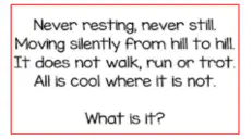
(a)
(a)
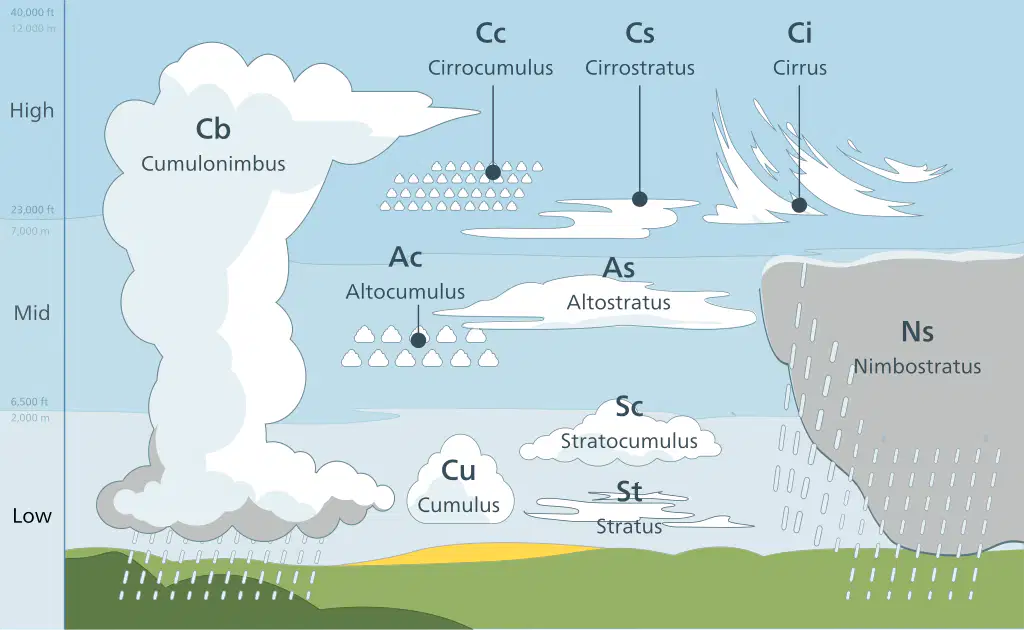
1. What are the thick, dark clouds that cover the sky at low to middle altitudes and bring continuous, steady precipitation? - (a)
2. What type of cloud is often associated with fair weather and has a fluffy, white appearance? - (b)
3. Which type of cloud is characterized by a uniform layer or sheet covering the sky, often resulting in overcast conditions? - (c)
4. What are the towering clouds with extensive vertical development, often associated with thunderstorms, heavy rain, and lightning? - (d)
5. Which type of cloud is thin and wispy, composed of ice crystals, and typically found at high altitudes? - (a)
6. What are the mid-altitude clouds that appear as gray or blue-gray sheets covering the sky and often precede storm systems? - (b)
7. What type of cloud is characterized by rounded masses or rolls and often appears in clusters or patches at mid-altitudes? (c)
8. Which cloud type is low-altitude and forms in layers or patches with a mix of cumulus and stratus characteristics? - (d)
The 1) (a) is composed of gases that surround the Earth, providing oxygen for life and protecting the planet from harmful solar radiation. The 2) (b) is the lowest layer of the atmosphere, where weather phenomena occur, while the 3) (c) is above it and contains the ozone layer. Next, the 4) (d) extends higher into the atmosphere, where temperatures decrease with altitude. The 5) (e) , located above the mesosphere, contains charged particles and is responsible for auroras.
Finally, the outermost layer, the 6) (a) , gradually transitions into outer space. As altitude increases in the atmosphere, temperatures generally 7) (b) in the troposphere, 8) (c) in the stratosphere due to the presence of the ozone layer, then 9) (d) again in the mesosphere, and finally 10) (e) ___ in the thermosphere due to absorption of solar radiation.
What is the CORRECT order of earth's atmospheric layers from its surface?
stratosphere, mesosphere, troposphere, thermosphere, exosphere
stratosphere, troposphere, mesosphere, thermosphere, exosphere
troposphere, mesosphere, stratosphere, thermosphere, exosphere
troposphere, stratosphere, mesosphere, thermosphere, exosphere
Which layer of atmosphere is the coldest?
mesosphere
troposphere
stratosphere
thermosphere
What happens to the temperature in the troposphere as the altitude increases?
Decreases
Increases
Cannot be determined
Remains the same.
In which layer of the atmosphere does passenger aircraft fly?
Lower Mesosphere
Lower Stratosphere
Middle Thermosphere
Upper Mesosphere
Which best describes the function of the atmosphere?
It is responsible for the tides.
It prevents heat from escaping into space too quickly.
It does not account for the heat gain or loss of the planet.
It allows heat to escape quickly into space to cool the planet.
Which best describes the greenhouse effect?
The ability of the stratosphere to receive sunlight.
The ability of the atmosphere to retain water vapor.
The ability of atmospheric gases to keep the planet warm.
The ability of clouds to scatter electromagnetic radiation in the atmosphere.
In which layer of the atmosphere makes the reception of radio waves around the earth possible?
Troposphere
Stratosphere
Mesosphere
Thermosphere
Ozone layer serves as shield from the incoming solar radiation. In which layer of
the atmosphere contains the large amounts of ozone?
Mesosphere
Stratosphere
Troposphere
Thermosphere
Which is TRUE about stratosphere?
There is no moving air in the stratosphere
The stratosphere destroys the ozone layer
The temperature is the same all through the layer
The temperature of stratosphere increases with altitude
What is the most abundant gas in the earth's atmosphere?
argon
nitrogen
oxygen
carbon dioxide
Which is the electrified region of the upper atmosphere?
ionosphere
mesosphere
stratosphere
thermosphere
What is the basis for the division of the layers of the atmosphere?
Changing temperature
Changing amount of oxygenChanging weather patterns
Changing weather patterns
Changing composition of gases
Clouds are categorized based on their altitude. Here’s how they fit into the different levels:
Cirrus
Cirrocumulus
Cirrostratus
Altocumulus
Altostratus
Stratus
Stratocumulus
Nimbostratus
Cumulus
Cumulonimbus
(a) – A seasonal wind pattern that brings heavy rainfall to the Philippines.
(b) – The primary source of energy for Earth's climate system.
(c) – It warms the atmosphere and is fundamental to atmospheric composition.
(d) – Large-scale wind patterns occur at the Earth's surface.
(e) – A seasonal wind pattern that brings dry and cool air blowing over the Philippine islands.
How does cloud formation start?
Cloud formation begins with the process of (a) , where heat from sources like the Sun gives (b) enough energy to transform from (c) and rise into the atmosphere. When this water vapor cools, it (d) on tiny particles in the air, known as (e) , to form clouds.
What is a condensation nucleus?
A (a) is a small particle, either solid or liquid, that provides a surface for (b) to condense upon. These particles can range from a few (c) to a few tenths of a micron in (d) and are essential for the formation of (e) .
Which cycle is the formation of clouds part of?
The formation of clouds is part of the (a) , which is the continuous movement of (b) within the Earth and atmosphere. This cycle includes the processes of (c) , (d) (cloud formation), and (e) (rain or snow).
Cloud Cloze A cloud is a visible condensation of water that is suspended in the air. Clouds form as warm air 1) (a) in the atmosphere and then cools 2) (b) . The 3) (c) heats water, which causes it to 4) (d) into the air. Warmer air rises and cooler air sinks. As the warmer air containing water vapor rises, it is cooled. As the water vapor cools, it 5) (e) into water droplets onto particles, such as dust, in the air. As more and more air cools, more droplets are formed and create different visible clouds
a. Warm air rises and cold air sinks. (a)
b. Warm air is more dense than cooler air. (b)
c. Air pressure is low over the tropics. (c)
d. Air pressure is high over the colder areas such as the poles. (d)
e. The difference in temperature creates wind. (e)
(a) 1. What factors determine the type of cloud that forms during cloud formation?
A. Wind speed B. Humidity levels C. Atmospheric pressure D. Temperature and humidity
(b) 2. Which of the following best describes the process of cloud formation?
A. Warm air rises and cools, causing water vapor to condense.
B. Cold air rises and warms, causing water vapor to condense.
C. Warm air sinks and cools, causing water vapor to evaporate.
D. Cold air sinks and warms, causing water vapor to evaporate.
(c) 3. What is the role of condensation nuclei in cloud formation?
A. absorbs water vapor. B. releases water vapor. C. causes water vapor to evaporate.
D. provides a surface for water vapor to condense onto.
(a) 4. What is the role of Coriolis effect in global wind patterns?
A. It has no effect on wind patterns. B. It causes winds to move in a straight line.
C. It accelerates wind speeds from the northern hemisphere to southern hemisphere.
D. It deflects winds to the right in the northern hemisphere and to the left in the southern hemisphere.
(b) 5. Which global wind pattern blows between 300 and 600 latitude in both hemispheres?
A. Easterlies B. Westerlies C. Trade winds D. Polar easterlies
(c) 6. What weather conditions are typically associated with the ITCZ?
A. Dry and arid conditions B. Clear skies and sunny weather
C. Heavy rainfall and thunderstorms D. Cold temperatures and moderate rain
(a) 7. How does the ITCZ contribute to global weather patterns?
A. Creating regions of high pressure at the poles
B. Causing hurricanes and typhoons near the equator
C. Generating strong westerly winds in the mid-latitudes
D. Influencing the movement of trade winds and monsoons
(b) 8. How does habagat affect the weather system of the Philippines?
A. It brings frequent heavy rainfall. B. It causes sunny and dry weather.
C. It causes droughts during May or June. D. It brings cold to moderate temperatures.
(a) 9. Will weather patterns exist if the earth’s surface receives the same amount of energy in all areas?
A. Yes, because air particles will move down and sink.
B. No, because air particles move up and create a high-pressure region.
C. No, because there will be no rising air particles, and this will not create differences in air pressure.
D. Yes, because there will be no differences in air pressures that will make the air move. in any direction.
(b) 10.Which is TRUE about cold air?
A. Cold air rises. B. Cold air sinks. C. Warm air is denser. D. Cold air spreads out.
(c) 11.In which direction does the wind flow in different parts of the world?
A. From low pressure area to a high-pressure area
B. From high pressure area to a low-pressure area
C. From low pressure area to another low-pressure area
D. From high pressure area to another high-pressure area
(a) 12.What type of monsoon occurs during the month of July?
A. Northeast monsoon
B. Northwest monsoon
C. Southeast monsoon
D. Southwest monsoon
(b) 13.How does Southwest monsoon affect the climate of a region?
A. By bringing heavy rainfall
B. By bringing dry weather and drought conditions
C. By moderating temperatures and reducing humidity
D. By creating stable weather patterns with minimal precipitation
(a) 14.Where are monsoons commonly experienced?
A. Near the poles
B. Near the equator
C. In tropical and subtropical regions
D. In the subtropical high-pressure belts
(b) 15.What weather conditions are associated with Amihan?
A. Dry and sunny weather
B. Hot and humid conditions
C. Heavy rainfall and thunderstorms
D. Cool temperatures and clear skies
The Earth's (a) causes day and night, while its (b) around the Sun brings about the changing (c) throughout the year.
Analyze the illustration and label the parts.
Match the following
(happens in
land)
Conduction
(occurs in the
bodies of water)
convection
(infrared and
visible light travels from
the sun to Earth)
Radiation

