
 Worksheets
Ocean and Atmosphere
Total questions: 112
Worksheet time: 3580secs
The process by which molecules at the surface of a liquid absorb enough energy to change to gas
Water that fills the cracks and spaces in underground soil and rock layers
An environment that provides the things a specific organism needs to live, grown and reproduce
Any form of water that falls from clouds and reaches Earth’s surface as rain, snow, sleet, or hail
The process by which water is lost through a plant’s leaves
The continual movement of water among Earth’s atmosphere, oceans, and land surface through evaporation, condensation, and precipitation
A wide sloping deposit of sediment formed where a stream leaves a mountain range
A landform made of sediment that is deposited where a river flows into an ocean or lake
The wide flat area along a river
A large channel in soil that carries runoff after a rainstorm
A region in which a layer of limestone close to the surface creates deep valleys, caverns, and sinkholes
A loop like bend in the course of a river
A meander cut off from a river
A tiny groove in soil made by flowing water
Water that flows over the ground surface rather than soaking into the ground
An icicle like structure that hangs from the ceiling of a cavern
A column like from that grows upward from the floor of a cavern
A channel through which water is continually flowing downhill
A stream or river that flows into a large river
A smooth, nearly flat region of the deep ocean floor
A gently sloping, shallow area of the ocean floor that extends outward from the edge of a continent
A undersea mountain chain where new ocean floor is produced
A steep incline of the ocean floor leading down from the edge of the Continental Shelf
The total amount of dissolved salts in a water sample
Saltiness
Salinity
A system that uses reflected sound waves to locate and determine the distance to objects under water
A steep-sided volcanic mountain rising from the deep ocean floor
A deep, steep-sided canyon in the ocean floor
A large stream of moving water that flows through the ocean
The effect of Earth’s rotation on the direction of winds and currents
The average annual conditions of temperature, precipitation, winds, and clouds in an area
An abnormal climate event that occurs every two to seven years in the Pacific Ocean, causing changes in the winds, currents, and weather patterns for one to two years
A climate event in the eastern Pacific Ocean in which surface waters are colder than normal
An area between the highest high tide line on land and the point on the continental shelf exposed by the lowest low tide
The area of the ocean that extends from the lo-tide line out to the edge of the continental shelf
The deepest, darkest area of the ocean beyond the edge of the continental shelf
Tiny algae and animals that float in water and are carried by water and currents
Free swimming animals that can move throughout the water column
Pelagic
Sessile
Nekton
Benthic
Organisms that live on the bottom of the ocean or another body of water
Pelagic
Benthos
Plankton
The pattern of overlapping feeding relationships or food chains among the various organisms in an ecosystem
The pressure caused by the weight of a column of air pushing down on an area
Air pressure
Elevation above sea level
Troposphere
Height
Attitude
Altitude
An instrument that measures changes in air pressure without using a liquid
An instrument that measures changes in air pressure
The ratio of the mass of a substance to its volume (m/v)
An instrument that measuring changes in air pressure, consisting of a glass tube partially filled with mercury, with open end resting in a dish of mercury
Aneroid Barometer
Mercury Barometer
A wave that can transfer electric and magnetic energy through the vacuum of space
The trapping of heat near a planet’s surface by certain gases in the planet’s atmosphere
Electromagnetic waves with wavelengths that are longer than visible light but shorter than microwaves
Reflection of light in all directions
Refraction
absorbtion
reflection
Scattering
Electromagnetic waves with wavelengths that are shorter than visible light but longer than x-rays
An instrument used to measure wind speed.
Winds that blow steadily from specific directions over long distances.
Global winds
Local winds
The flow of air from land to a body of water.
The distance in degrees north or south of the equator.
Winds that blow over short distances.
Global Winds
Sea Breezes
Local Winds
Land Breezes
The flow of cooler air from over an ocean or lake toward land.
The horizontal movement of air from an area of high pressure to an area of lower pressure.
A measure of cooling combining temperature and wind speed.
A huge body of air that has similar temperature, humidity, and air pressure at any given height.
Bands of high-speed winds about 10 km above Earth’s surface.
A humid air mass that forms over oceans.
Cut off, as in a front where a warm air mass is caught between two cooler air masses.
Occluded front
A cold air mass that forms north of 50o north latitude or south of 50o south latitude and has high air pressure.
A warm air mass that forms in the tropics and has low air pressure.
The climate of the centers of continents, with cold winters and warm or hot summers.
The side of a mountain range that faces away from the oncoming wind.
The climate of some coastal regions, with relatively warm winters and cool summers.
Tropical climate
Maritime climate
Sea or land breeze over a large region that changes direction with the seasons.
The areas near both poles from about 66.5o to 90o north and 66.5o to 90o south latitudes.
Polar zone
Tropical zone
Desert zone
The areas between the tropical and the polar zones.
The area near the equator between about 23.5o north latitude and 23.5o south latitude.
Tropic zone
Polar zone
The side of a mountain range that faces the oncoming wind.
Salinity is a measure of which of the following in water?
What is the most abundant salt in seawater?
Two gasses found in ocean water that are needed for living things are:
A large stream of moving water that flows through the oceans is called a(n)
In which zone is ocean temperature most affected by the weather?
Surface Zone
Transition Zone
Currents
Exploring the deep zone is difficult because of its:
Extreme Pressure
Extreme Temperatures
Darkness
Abundant Plant life
The densest ocean water is generally found
As you go deeper in the ocean, all of the following decrease except:
Plant life
Earth’s rotation makes global winds curve. This is called the
What causes cold, deep currents to form in the oceans near the poles?
cold temperatures and increased salinity.
Which of the following increase salinity?
Evaporation
ice melting
percipitation
Decreased temperature
The density of seawater depends on:
The process in which deep, cold water and nutrients rises and mixes with surface water is called
What is the name of the process by which water vapor enters the atmosphere during the water cycle?
Cold, dry air affecting the northern United States in winter often comes from
Continental polar air mass
Maritime tropical air mass
Continental tropical air mass
Maritime polar air mass
Weather associated with an anticyclone is generally
dry and clear
The greenhouse effect is
Local winds differ from global winds because they
Local winds are influenced by unequal heating in a small area
Which is the major source of energy for most of Earth’s weather patterns?
radiation from the sun
Which statement best describes why a valley glacier moves?
Gravity pulls the glacier downhill.
Ice at the top of the glacier pushes on the rest of the glacier.
Melting at the bottom of the glacier makes room for the ice higher up on the glacier.
Ice is slippery.
The major agent of erosion that has shaped Earth’s land surface is
What causes a glacier to move?
The force of gravity causes the layers to flow downhill.
The glacier begins to melt and the water runs downhill.
Wind pushes the glacier downhill.
An earthquake causes the glacier to move.


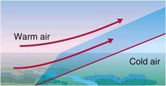


How will location Z be affected by evaporation and wind?
Increased precipitation
Decreased cloud cover
Increased amounts of salt
Increased drought

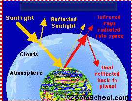
How are humans contributing to the Greenhouse Effect
By increasing the rate of chemical and mechanical weathering
By shopping too much
By watching Netflix on the weekends and eating strawberry popcorn all day
By increasing Carbon Dioxide (CO2)

Two containers were placed in front of a lamp for 10 minutes. Both containers were filled with air. Additional carbon dioxide was added to one container. The final temperatures of both containers are shown.
What does this experiment prove?
Carbon dioxide is a greenhouse gas that traps heat.
Carbon dioxide is not a greenhouse gas that traps heat.
The experiment does not prove anything.


Winds are created by ....
unequal distribution of the Earth's magnetic field
unequal heat distribution of the Earth's surface
unequal distribution of gravitational forces
gravitational influence of the moon and sun

At higher altitudes, temperatures are often cooler because there is ______ air pressure, so there are _____ air molecules to absorb the heat.
more, more
more, fewer
less, more
less, fewer


