wayground logo

Free Printable Worksheets

Font size

S
M
L
XL
Worksheets

Unit 3: Cycles and Patterns of Earth and the Moon Review

Total questions: 125

Worksheet time: 2hrs 1mins

Name
Class
Date
1.
What causes wind to blow?
a)
Differences in longitude
b)
Shock waves from clouds
c)
Differences in air temperature and pressure
d)
The rotation of earth
2.
If you wanted to find the jet stream, where would you go? 
a)
The area around the poles
b)
The area around the equator
c)
10 km above the earth's surface
d)
1 km above the earth's surface
3.
What causes warm air to rise? 
a)
The fact that it's less dense than cold air
b)
The fact that it weighs more than cold air
c)
The fact that it has higher pressure than cold air
d)
The fact that it's more dense than cold air
4.
Scientists who study weather and try to predict it are called
a)
astronomers
b)
climatologist
c)
meteorologist
d)
weatherologist
5.
Climate is
a)
the further you get from the equator
b)
the higher you go, the colder it gets
c)
the conditions of the atmosphere at a certain place and time.
d)
the average weather conditions of an area over a long period of time.
6.
If the Earth did not rotate on its axis, there would be no
a)
Greenhouse effect
b)
Coriolis effect
c)
Global warming
d)
Convection
7.
Earth’s climate system is powered mainly by energy from:
a)
Tilt
b)
The sun
c)
Latitude
d)
The rain shadow
8.
Cities closer to water most likely will be
a)
more dry
b)
more humid
c)
hotter
9.
Movements of ocean water in a continuous flow are called?
a)
ocean currents
b)
global winds
c)
air mass
d)
front
10.
What causes ocean currents in the Northern Hemisphere to curve to the right?
a)
Earth's orbit around the Sun
b)
Earth's spinning on its axis
c)
Earth's magnetic field
d)
Earth's force of gravity
11.
Why are surface currents at the surface of the ocean?
a)
colder temperature
b)
colder temperature & more salinty
c)
warmer temperature & less salinty
d)
less salinty
12.
Where is ocean water the densest.
a)
The surface
b)
The middle
c)
The bottom
d)
Lake Michigan
13.
Ocean currents bring warm water from the equator towards Earth's
a)
Southern Hemisphere
b)
Continents
c)
Equator
d)
Poles
14.
What causes surface currents north and south of the equator to move in different directions? 
a)
Gases in the ocean
b)
The rotation of the Earth
c)
Temperature differences
d)
Continental deflection
15.

________ and _______ affect the ocean's density and cause the Global Conveyor Belt to travel

a)

gravity and the Coriolis Effect

b)

temperature and salinity

c)

wind and climate

d)

temperature and the Coriolis Effect

16.

The more scientific name of the Global Conveyor Belt is _____.

a)

halinethermal circulation

b)

thermohaline circulation

c)

thermodensity circulation

17.

Ocean currents affect climates around the world. Based on the map, which area MOST likely has a warmer climate than expected?

a)

1

b)

2

c)

3

d)

4

18.

Surface currents are a result of

a)

Global Wind Patterns

b)

Earth's Rotation

c)

Density

d)

All of the above

19.

Deep Ocean currents are a result of

a)

Global Wind Patterns

b)

Earth's Rotation

c)

Density

d)

All of the above

20.

The Coriolis Effect is caused by

a)

Earth rotating around the sun

b)

Earth rotating on its axis

c)

The tides

d)

Gravity

21.

The Gulf stream carries _____________ water from the east coast of The United States to the West coast of Europe.

a)

Cold

b)

Warm

c)

Freezing

d)

Fresh

22.

Due to the Coriolis Effect, water in the northern hemisphere moves

a)

clockwise

b)

counter clockwise

c)

both

d)

neither

23.

What are a circular system of currents in the Earth's major oceans?

a)

ocean current

b)

gyre

c)

upwelling

d)

conveyor belt

24.

Constantly moving system of deep-ocean circulation driven by temperature and salinity. It moves water around the globe.

a)

California Current

b)

Global Conveyor Belt

c)

Surface Currents

d)

Gulf Stream

25.

When surface currents meet continents they ___?

a)

Stop moving

b)

Are deflected (change paths)

c)

Continue in the direction they were going

26.
The Coriolis Effect is caused by
a)
Earth rotating around the sun
b)
Earth rotating on its axis
c)
The tides
d)
Gravity
27.
What happens to a current when it comes in contact with a continent or landmass?
a)
It continues over the continent
b)
It stops
c)
It changes direction
d)
It is absorbed by the land
28.
A horizontal movement of ocean water that is caused by wind and that occurs at or near the ocean's surface.
a)
Gulf Stream
b)
Global Conveyor Belt
c)
Surface Current
d)
Gyre
29.
What process brings the deep cold ocean currents up to the surface?
a)
Conduction
b)
Global Wind Patterns
c)
Convection Currents
d)
Temperature and salinity
30.
What causes surface currents north and south of the equator to move in different directions? 
a)
Gases in the ocean
b)
The rotation of the Earth
c)
Temperature differences
d)
Continental deflection
31.

_______ causes the Coriolis Effect

a)

Earth's rotation

b)

gravity

c)

wind

d)

density

32.

Salinity is

a)

The salt content of a substance

b)

The Pepper content of a substance

c)

The circulation of hot and cold matter

d)

the weather pattern of a region

33.

The movement of deep, cold, nutrient filled water to the surface of the ocean is..

a)

Ocean Current

b)

Upwelling

c)

Deep Currents

d)

Surface Currents

34.
Two types of water currents are
a)
local and global
b)
sea and land
c)
surface and deep
d)
warm and cold
35.
Regular movements of water far below the oceans surface are called
a)
Warm Currents
b)
Deep Currents
c)
Shallow Currents
d)
Surface Currents
36.
Ocean water is more dense than fresh water at the same temperature due to differences in:  
a)
Wind patterns
b)
 Lifeforms
c)
Currents
d)
Salinity
37.

What affects the density of water?

a)

Salt

b)

Temperature

c)

The seasons of the year

d)

Both A and B

38.
What can you conclude about prevailing winds from their name? 
a)
They blow from west to east
b)
They blow all the time
c)
The air they contain is very warm 
d)
The air they contain is very cool
39.
What creates the air pressure difference between the equator and the poles?
a)
The length of the seasons
b)
The shape of the earth 
c)
the duration of the solar year
d)
The amount of direct sunlight each area receives 
40.
What causes wind to blow?
a)
Differences in longitude 
b)
Shock waves from clouds 
c)
Differences in air temperature and pressure 
d)
The rotation of the earth
41.
Why does a sea breeze at the beach keep you cool and comfortable during the hottest part of the day?
a)
warm air rising over land lets cooler air from the ocean blow in
b)
a storm is approaching
c)
cool air rising over land lets warm air from the ocean blow in
d)
Similarities in temperature between land and water
42.
Uneven heating of the Earth's atmosphere causes which of the following?
a)
Greenhouse Effect
b)
Local and global winds
c)
Infrared Radiation
d)
Global temperature increase
43.
Which term best describes how the earth's atmosphere is heated?
a)
Spirally
b)
Unevenly
c)
Circularly
d)
Kinetically
44.
What causes warm air to rise?
a)
the fact that it's less dense than cold air 
b)
The fact that it weighs more than cold air 
c)
The fact that it has higher pressure than cold
d)
the fact that its more dense than cold air 
45.
The reason why global winds flow from east to west and west to east, but not north to south, or south to north.
a)
Bernoulli's principle 
b)
Coriolis effect 
c)
high pressure 
d)
low pressure 
46.
What is the name for cooler air blowing from the land to the sea?
a)
Sea Breeze
b)
Land Breeze
c)
Mountain Breeze
d)
None of the Above
47.
True or False:
Land heats and cools faster than water causing wind and weather.
a)
True
b)
False
48.
What is the name for cooler air blowing from the sea to land?
a)
Sea Breeze
b)
Land Breeze
c)
Mountain Breeze
d)
None of the Above
49.
What do you call winds that blow in the same direction all over the Earth?
a)
global winds
b)
Coriolis effect
c)
Greenhouse effect
d)
sea breezes
50.
What winds blow from west to east in the temperate zone and move weather patterns across the United States?
a)
prevailing westerlies
b)
polar easterlies
c)
trade winds
d)
jet streams
51.
What are cold winds that blow from east to west in the polar regions?
a)
polar easterlies
b)
trade winds
c)
prevailing westerlies
d)
jet streams
52.
What kind of breeze is this and when would it form?
a)
Land breeze - daytime
b)
Land breeze - nighttime
c)
Sea breeze - daytime
d)
Sea breeze - nighttime
53.
Wind blows from ______ pressure areas to _____ pressure areas.
a)
high; low
b)
warm; cool
c)
cool; warm
d)
low; high
54.
Water is _______ than land during the day, causing a sea breeze.
a)
more inviting
b)
larger
c)
cooler
d)
warmer
55.
Global winds over the United States blow in which direction?
a)
east to west
b)
north to south
c)
south to west
d)
west to east
56.
___________is the result of the weight of a column of air pushing on an area.
a)
air pressure
b)
density
c)
volume
d)
none of the above
57.
This type of wind comes from the POLES. It blows from east to west and brings freezing weather. 
a)
Prevailing Westerlies
b)
Polar Easterlies
c)
Polar Westerlies
d)
Horse Latitudes
58.
Currents that are far beneath the surface
a)
deep ocean currents
b)
surface currents
c)
current
d)
global winds
59.
Which of the following is true of El Nino?
a)
El Nino usually occurs twice a year.
b)
El Nino can cause unusual and often severe weather conditions.
c)
El Nino affects only the ocean, not the land.
d)
El Nino occurs at the same time as La Nina.
60.

Ocean water is _______________ near the equator.

a)

warmer

b)

colder

c)

choppy

d)

more dense

61.

Ocean water flows in continuous paths called -

a)

climates

b)

prevailing winds

c)

poles

d)

currents

62.

Energy in fluids (gases and liquids) moves from _____ areas to _____ areas

a)

colder to warmer

b)

warmer to colder

c)

warm to warm

d)

cold to cold

63.

If the ocean water is 24 degrees and the air is 38, energy will -

a)

transfer from the ocean to the air

b)

remain in the ocean

c)

transfer from the air to the ocean

d)

remain in the air

64.

The poles receive ______ energy from the Sun than the equator.

a)

the same

b)

less

c)

more

65.

Ocean currents __________ __________ throughout the ocean and atmosphere.

a)

cause storms

b)

decrease energy

c)

increase energy

d)

transfer energy

66.

If the air temperature is 25 and the ocean temperature is 29 -

a)

energy will transfer from the ocean to the air

b)

energy will transfer from the air to the ocean

c)

no energy will be transferred

67.

Colder, saltier, more dense water in the deep ocean --

a)

moves southward, mixes with warmer surface water, and circulates around the Earth

b)

moves northward, mixes with colder surface water, and circulates around the Earth

c)

remains in the deep ocean, never moving

68.

A measure of the total energy something has

a)

charge

b)

temperature

c)

climate

d)

electricity

69.

Energy is transferred -

a)

from the Sun directly to the air, then some of that energy is transferred to the surface

b)

from the air to the Sun, then back to the surface

c)

from the Sun directly to the surface, then some of that energy is transferred to the air

d)

only from the Sun to oceans

70.

A climate pattern that happens every 2 to 7 years

a)

Hurricane season

b)

El Niño

c)

Gyre

d)

Prevailing winds

71.
The __________________ are responsible for the movement of much of the weather across the United States.
a)
prevailing westerlies
b)
polar easterlies
c)
trade winds
d)
doldrums
72.
Steady winds between the equator and 30 latitude north and south are known as the _______________. 
a)
doldrums
b)
jet streams
c)
easterlies
d)
trade winds
73.
Winds blowing from the northeast to the southwest near the North Pole are known as _________________________________.
a)
Prevailing westerlies
b)
trade winds
c)
doldrums
d)
polar easterlies
74.
Air masses moving in the northern hemisphere are turned westward from their original paths in the _______________________.
a)
jet streams
b)
Coriolis effect
c)
trade winds
d)
prevailing westerlies
75.
A windless zone at Earth’s equator where air rises almost straight up is called the _______________________.
a)
prevailing westerlies
b)
trade winds
c)
doldrums
d)
polar easterlies
76.
The ___________________ blow from southwest to northeast at 30° to 60° latitude in the northern hemisphere. 
a)
prevailing westerlies
b)
polar easterlies
c)
trade winds
d)
doldrums
77.
Each hemisphere has two narrow belts of fast-moving winds called ____________________. 
a)
sea breeze
b)
land breeze
c)
jet stream
d)
doldrum
78.
How can the temperature of sand and water affect the climate of an area?
a)
The area will take on the temperature of the sand and water around it.
b)
The temperature of sand and water do not affect the climate of an area.
c)
The temperature of the sand makes the area warmer. Water does nothing.
d)
The temperature of the water makes the area cooler. Sand does nothing.
79.
The _________ are windless zones near the equator
a)
doldrums
b)
prevailing westerlies
c)
polar easterlies
d)
trade winds
80.
Which city has the greatest temperature range? 
a)
A
b)
B
c)
C
d)
D
81.
Which city is located closest to the Equator? 
a)
A
b)
B
c)
C
d)
D
82.
Base your answers to questions 16 through 18 on the ESRT and the graphs below. The graph shows the average monthly temperatures at cities A, B, C, and D. The latitude of each city is also indicated.
What is the average temperature in March for city C? 
a)
7°C
b)
2°C
c)
-7°C
d)
-4°C
83.

What is the average weather of an area over a long period of time?

a)

climate

b)

weather

84.

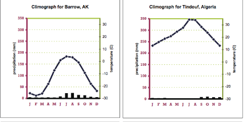
Identify the factor that influence the temperature of these two areas

a)

Latitude

b)

Elevation

c)

Distance from Large Bodies of Water

d)

Ocean Currents

85.

Which city will have a cooler average temperature

a)

Chapel Hill

b)

Havana

86.

Which climate zone is this?

a)

Polar climate zone

b)

Temperate climate zone

c)

Tropical climate zone

87.

Which climate zone is closest to the equator?

a)

Polar climate zone

b)

Temperate climate zone

c)

Tropical climate zone

88.
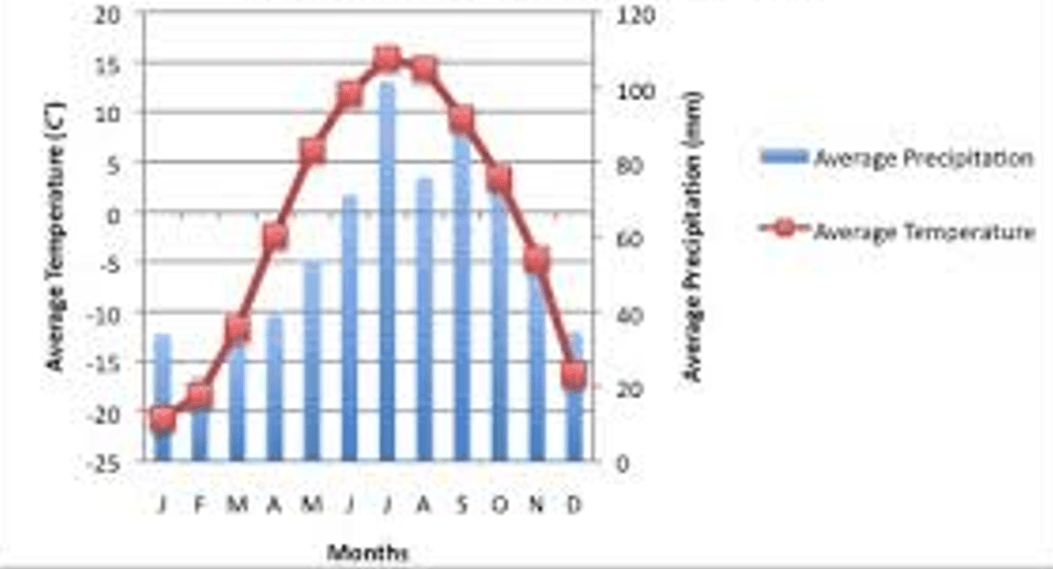
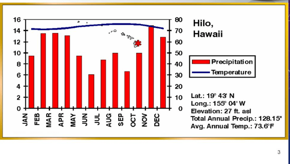
The line graph represents?
a)
Temperature
b)
Precipitation
c)
Wind Direction
89.
The bar graph represents?
a)
Temperature
b)
Precipitation
c)
Wind Direction
90.

Which month has the coldest temperature?

a)

January

b)

April

c)

September

d)

March

91.

In which month do they get the most rain in this biome?

a)

January

b)

May

c)

August

d)

November

92.

When does the least precipitation occur?

a)

February - March

b)

April - May

c)

June - July

d)

November - December

93.

Which months have the warmest temperatures?

a)

December, January, February

b)

March, April, May

c)

June, July, August

d)

September, October, November

94.

When is there the most precipitation & highest temperatures?

a)

February

b)

July

c)

September

d)

December

95.

What is being shown on the X axis?

a)

Months

b)

Temperature

c)

Precipitation

d)

Years

96.

During what month is the highest amount of precipitation

a)

January

b)

August

c)

May

d)

July

97.

What is the temperature range for this biome?

a)

10

b)

20

c)

30

d)

250

98.

The ____ stays relatively stable over the whole year in this biome.

a)

temperature

b)

precipitation

c)

temperature and precipitation

99.

Which of the following is a similarity between these two biomes

a)

low temperatures

b)

high temperatures

c)

low precipitation levels

d)

permanently frozen ground

100.

Which hemisphere is this biome located in?

a)

Northern Hemisphere

b)

Southern Hemisphere

101.
The Earth's atmosphere is mainly made of
a)
water
b)
snow
c)
wax
d)
air
102.
The layer of atmosphere closest to the Earth is called the
a)
mesosphere
b)
stratosphere
c)
troposphere
d)
proctosphere
103.
Air in the atmosphere is 78%
a)
Einsteinium
b)
nitrogen
c)
oxygen
d)
carbon dioxide
104.
The atmosphere is 21%
a)
nitrogen
b)
oxygen
c)
argon
d)
flatulence
105.
Altitude is the  (use the internet for this answer)
a)
distance between the moon and the sun
b)
weight of a mountain divided by the ocean
c)
place where things drop from the sky
d)
height of an object above the ground or sea level
106.
air pressure is the ________ that air has on a surface or object 
a)
height
b)
distance
c)
force
d)
protuberance
107.
The ozone layer
a)
is green and purple
b)
absorbs dangerous solar radiation
c)
smells like sulphur
d)
is made of carbon dioxide
108.
The greenhouse effect causes the Earth's air to
a)
heat up
b)
cool down
c)
blow up
d)
turn brown
109.
The ozone layer is located in the 
a)
biosphere
b)
atmsophere
c)
geosphere
d)
cryosphere
110.
The ozone layer occurs in the 
a)
troposphere
b)
thermosphere
c)
stratosphere
d)
exosphere
111.
The _________________ is the process by which gases in the atmosphere absorb and give off heat
a)
ozone layer
b)
greenhouse effect
c)
coriolis effect
d)
thermosphere
112.
As altitude increases, the air pressure 
a)
decreases
b)
stays the same
c)
increases
d)
all of the above
113.
Most of Earth's weather occurs in the 
a)
troposphere
b)
stratosphere
c)
mesophere
d)
thermosphere
114.

The stratosphere is located between

a)

thermosphere and mesosphere

b)

core and mantle

c)

troposphere and mesosphere

d)

exosphere and mesosphere

e)

your head and Uranus

115.
Over the past 30 years, air quality in the United States has generally _______________
a)
improved
b)
declined
116.
One cause of ________________ is the burning of coal that contains a lot of sulfur.
a)
acid rain
b)
soot
117.
Harmful substances in air, water, or soil are called ________________.
a)
pollutants
b)
particles
118.

Ground level ozone (also known as tropospheric ozone) is ______________________.

a)

a significant source of air pollution and contributes to the formation of smog

b)

also found in the exosphere

c)

found only in rural areas

d)

a significant source of air pollution and contributes to the increase in the hole in the ozone layer.

119.

Ozone is made up of __________________ oxygen atoms.

a)

3

b)

2

c)

1

d)

5

120.

The atmospheric layer that humans live in is known as the _____________________.

a)

troposphere.

b)

stratosphere.

c)

exosphere.

d)

thermosphere.

121.

"Criteria Air Pollutants" were established by the _________________________________.

a)

Environmental Protection Agency (EPA)

b)

Department of the Interior (DI)

c)

Center for Disease Control (CDC)

d)

United Nations (UN)

122.

Nitrous oxides enter the atmosphere from _____________________.

a)

fossil fuels

b)

meteorites

c)

ozone depletion

d)

CFC's

123.

Chlorofluorocarbons is represented by the abbreviation _________________.

a)

CFC

b)

ChFC

c)

Chl

d)

hydrocarbons

124.

Bad or Hazardous ozone is found in the _______________________________.

a)

troposphere

b)

stratosphere

c)

mesosphere

d)

thermosphere

125.

The most common source of carbon monoxide comes from _____________________________.

a)

vehicles

b)

swamp gases

c)

industrial sources

d)

none of these